54:
42:
124:
401:
396:
117:
406:
221:
261:
237:
177:
162:
362:
217:
303:
321:
253:
245:
53:
390:
327:
315:
193:
340:
281:
91:
280:
Among the notable summits which surround the valley (all of them belonging to the
233:
229:
201:
139:
126:
197:
41:
17:
269:
173:
106:
257:
249:
225:
265:
213:
378:
241:
181:
110:
59:
116:
102:
97:
87:
82:
74:
66:
29:
365:1:10.000 (vers.3.0) of Regione Piemonte - 2007
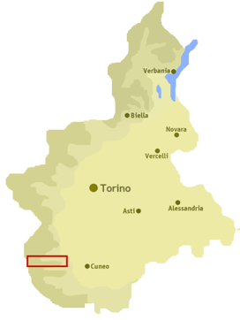
8:
78:around 45 km (28 mi) west east
26:
192:The valley takes its name from the river
352:
70:500–3,412 m (1,640–11,194 ft)
58:Location of the valley in Piedmont, NW
7:
25:
204:which flows through the valley.
52:
40:
379:http://www.valligranaemaira.it/
172:) is a valley in south-west of
46:The highest part of the valley
1:
294:Brec de Chambeyron - 3412 m
423:
309:Rocca la Marchisa - 3072 m
297:Tête de la Frema - 3143 m
51:
39:
34:
300:Monte Chersogno - 3026 m
360:Carta Tecnica Regionale
312:Monte Maniglia - 3177 m
291:Buc de Nubiera - 3215 m
288:Monte Oronaye - 3100 m
35:Val Maira, Valle Macra
347:Notes and references
140:44.50194°N 7.13778°E
402:Valleys of the Alps
397:Valleys of Piedmont
222:Villar San Costanzo
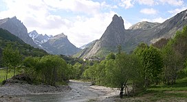
136: /
216:of the valley are
407:Province of Cuneo
238:San Damiano Macra
178:Province of Cuneo
156:
155:
145:44.50194; 7.13778
16:(Redirected from
414:
383:
366:
357:
151:
150:
148:
147:
146:
141:
137:
134:
133:
132:
129:
56:
44:
27:
21:
422:
421:
417:
416:
415:
413:
412:
411:
387:
386:
381:
375:
370:
369:
358:
354:
349:
337:
278:
276:Notable summits
210:
196:, a right-hand
190:
144:
142:
138:
135:
130:
127:
125:
123:
122:
67:Floor elevation
62:
47:
23:
22:
15:
12:
11:
5:
420:
418:
410:
409:
404:
399:
389:
388:
385:
384:
374:
373:External links
371:
368:
367:
351:
350:
348:
345:
344:
343:
336:
333:
332:
331:
325:
322:Punta Tempesta
319:
313:
310:
307:
301:
298:
295:
292:
289:
277:
274:
246:Celle di Macra
214:municipalities
209:
206:
189:
186:
154:
153:
120:
114:
113:
104:
100:
99:
95:
94:
89:
85:
84:
80:
79:
76:
72:
71:
68:
64:
63:
57:
49:
48:
45:
37:
36:
32:
31:
24:
14:
13:
10:
9:
6:
4:
3:
2:
419:
408:
405:
403:
400:
398:
395:
394:
392:
380:
377:
376:
372:
364:
361:
356:
353:
346:
342:
339:
338:
334:
329:
328:Monte Birrone
326:
323:
320:
317:
316:Rocca la Meja
314:
311:
308:
305:
302:
299:
296:
293:
290:
287:
286:
285:
284:) there are:
283:
275:
273:
271:
267:
263:
259:
255:
251:
247:
243:
239:
235:
231:
227:
223:
219:
215:
207:
205:
203:
199:
195:
187:
185:
183:
179:
175:
171:
167:
164:
160:
149:
121:
119:
115:
112:
108:
105:
101:
96:
93:
90:
86:
81:
77:
73:
69:
65:
61:
55:
50:
43:
38:
33:
28:
19:
382:(in Italian)
359:
355:
341:Cottian Alps
304:Pelvo d'Elva
282:Cottian Alps
279:
211:
191:
169:
165:
159:Maira Valley
158:
157:
92:River valley
30:Maira Valley
170:Valle Macra
143: /
118:Coordinates
18:Valle Maira
391:Categories
234:Cartignano
230:Roccabruna
128:44°30′07″N
208:Geography
198:tributary
188:Etymology
166:Val Maira
131:7°08′16″E
98:Geography
335:See also
330:- 2131 m
324:- 2679 m
318:- 2831 m
306:- 3064 m
270:Acceglio
174:Piedmont
107:Piedmont
103:Location
262:Marmora
258:Canosio
250:Stroppo
226:Dronero
200:of the
176:in the
163:Italian
152:
83:Geology
363:raster
266:Prazzo
75:Length
242:Macra
218:Busca
194:Maira
182:Italy
111:Italy
60:Italy
268:and
254:Elva
212:The
161:(in
88:Type
168:or
393::
272:.
264:,
260:,
256:,
252:,
248:,
244:,
240:,
236:,
232:,
228:,
224:,
220:,
202:Po
184:.
180:,
109:,
20:)
Text is available under the Creative Commons Attribution-ShareAlike License. Additional terms may apply.