154:
147:
427:
592:
794:. A headland consisting of steep cliffs marked by rocky exposures, located just west of the mouth of Vane Glacier. The headland is the north extremity of a mountainous ridge descending from the central part of the Mount Murphy massif. Mapped by USGS from surveys and United States Navy air photos, 1959–66. Named by US-ACAN for Commander (later Captain) Harry B. Eisberg, United States Navy, Staff Medical Officer on Operation Highjump, 1946–47.
680:. A sharp peak rising midway along the north wall of Roos Glacier in the northwest part of the Mount Murphy massif. Mapped by USGS from surveys and United States Navy aerial photographs, 1959–66. Named by US-ACAN for Robert J. Buettner (1914–75), manager of contract logistics support provided to the United States Antarctic program by Holmes and Narver, Inc. This work took him to Antarctica at least five times between 1969 and 1974.
40:
718:. A peak over 1,400 metres (4,600 ft) high, one of several named peaks on the Mount Murphy massif. The feature is located on the northeast spur of the massif, between Benedict Peak and the loftier summit peaks. Mapped by USGS from surveys and United States Navy air photos, 1959–66. Named by US-ACAN for Edward Grew, United States Exchange Scientist to the Soviet Antarctic station Molodezhnaya in 1973.
832:. Precipitous, mainly ice-covered subsidiary peak on the Mount Murphy massif, located 9 nautical miles (17 km; 10 mi) east-northeast of the summit of Mount Murphy. First mapped by USGS from air photos obtained in January 1947 by United States Navy Operation Highjump. Named by US-ACAN after Lieutenant Gordon W. Callender (CEC), United States Navy, officer in charge of Byrd Station in 1966.
870:. Prominent headland close east of the mouth of Vane Glacier on the coast of Marie Byrd Land. It rises over 1,000 metres (3,300 ft) high and has rock exposed to seaward. Mapped by USGS from surveys and United States Navy air photos, 1959–66. Named by US-ACAN for Captain Hugh F. Boyd III, United States Army, Construction Projects Officer during Operation Deep Freeze 1972 and 1973.
1066:. Conspicuous, nearly bare rock summit rising to 600 nautical miles (1,100 km; 690 mi) south of Hedin Nunatak. The peak is joined at its south side to an ice-covered spur which descends southwest from Mount Murphy. Mapped by USGS from surveys and United States Navy air photos, 1959–66. Named by US-ACAN after John P. Turtle, aurora researcher at Byrd Station in 1962.
600:
464:. A glacier about 20 nautical miles (37 km; 23 mi) long, flowing north along the west side of Mount Murphy to Crosson Ice Shelf. Mapped by USGS from surveys and United States Navy air photos, 1959–66. Named by US-ACAN after Major Donald R. Pope, (CE) United States Army, civil engineer on the staff of the Commander, Naval Support Force, Antarctica, 1965–67.
642:. A pyramidal peak, 760 metres (2,490 ft) high, near the end of the large spur descending northwest from the Mount Murphy massif. Mapped by USGS from surveys and United States Navy air photos, 1959–66. Named by US-ACAN for Lieutenant Commander W. Kay, United States Navy, leader of the Construction Unit at South Pole Station during Operation Deep Freeze 1973.
1104:. A conspicuous nunatak with a flat top capped with ice and steep bare rock walls, standing 9 nautical miles (17 km; 10 mi) west-northwest of the summit of Mount Murphy. First roughly mapped from air photos taken in January 1947 by United States Navy Operation Highjump. Named by US-ACAN after Alan E. Hedin, aurora researcher at Byrd Station in 1962.
1028:. A rock outcrop 11 nautical miles (20 km; 13 mi) southwest of the summit of Mount Murphy, protruding through the ice near the head of Pope Glacier. Mapped by USGS from surveys and United States Navy air photos, 1959–66. Named by US-ACAN after Leo E. Dorrel, United States Navy, hospital corpsman with the Byrd Station winter party, 1966.
1448:
1413:
908:. A small summit peak on a mostly ice covered and rounded mass located 7 nautical miles (13 km; 8.1 mi) southeast of Mount Murphy. Mapped by USGS from surveys and United States Navy air photos, 1959–66. Named by US-ACAN for Major Billy R. Hawkins, a member of the United States Army Aviation Detachment in Antarctica, 1966–67.
540:. A broad glacier that drains the northeast slopes of Mount Murphy. It enters Crosson Ice Shelf between Eisberg Head and Boyd Head. Mapped by USGS from surveys and United States Navy air photos, 1959–66. Named by US-ACAN for Gregg A. Vane, United States Exchange Scientist at the Soviet station Novolazerevskaya in 1972.
946:. One of the highest peaks 2,445 metres (8,022 ft) high in the west-central summit area of the Mount Murphy massif. Mapped by USGS from surveys and United States Navy air photos, 1959–66. Named by US-ACAN for noted American geologist Walter H. Bucher, Professor of Geology at Columbia University, 1940–56.
756:. A sharp, mostly ice-covered subsidiary peak standing 6 nautical miles (11 km; 6.9 mi) northeast of the summit of Mount Murphy. Mapped by USGS from surveys and United States Navy air photos, 1959–66. Named by US-ACAN for Philip C. Benedict, aurora researcher at Byrd Station in 1966.
341:
of Marie Byrd Land. The Haynes
Glacier flows into the ice shelf to its east, and the Pope Glacier flows into the ice shelf to the west. The Roos Glacier and Vane Glacier flow from the massif towards the ice shelf. Features, clockwise from the northwest, include Kay Peak, Buettner Peak, Grew Peak,
984:. A peak 1,350 metres (4,430 ft) high on the southwest spur of the Mount Murphy massif. Mapped by USGS from surveys and United States Navy air photos, 1959–66. Named by US-ACAN for Frank S. Sechrist, United States Exchange Scientist at the Soviet Molodezhnaya station in 1975.
412:(USGS) from surveys and United States Navy air photos, 1959–66. Named by US-ACAN after Major John W. Haynes, USMC, aircraft pilot on Operation Deep Freeze 1967 and 1968, who made a photographic flight over this glacier on January 1, 1967.
1452:
1417:
365:
of the
American Museum of Natural History, noted authority on Antarctic and sub-Antarctic bird life. While serving on the whaler, he charted the Bay of Isles region of South Georgia.}
502:. A steep glacier that drains the northwest slopes of Mount Murphy. Named by US-ACAN after S. Edward Roos, oceanographer with the Byrd Antarctic Expeditions of 1928-30 and 1933–35.
94:
1492:
1421:
146:
1487:
1477:
1472:
358:
342:
Benedict Peak, Eisberg Head, Callender Peak, Boyd Head, Hawkins Peak, Bucher Peak, Sechrist Peak, Dorrel Rock, Turtle Peak, Hedin
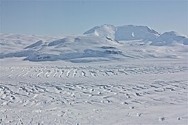
Nunatak.
248:
1482:
222:
1456:
409:
87:
229:
1076:
1038:
1000:
956:
918:
880:
842:
804:
766:
728:
690:
652:
614:
512:
474:
436:
380:
1143:
553:
1148:
205:
65:
362:
80:
580:
195:
575:
354:
351:
75:
591:
285:) is a snow-covered mountain with steep, rocky slopes rising to 2,505 metres (8,219 ft) in
330:
570:
426:
318:
408:. A broad glacier flowing to Walgreen Coast, to the east of Mount Murphy. Mapped by the
286:
179:
1122:
1428:
338:
314:
290:
217:
210:
39:
1466:
294:
1395:
421:
334:
993:
310:
234:
1138:
183:
1091:
1078:
1053:
1040:
1015:
1002:
971:
958:
933:
920:
895:
882:
857:
844:
819:
806:
781:
768:
743:
730:
705:
692:
667:
654:
629:
616:
527:
514:
489:
476:
451:
438:
395:
382:
264:
250:
110:
96:
599:
565:
17:
309:
lava. Volcanism on the slopes of the volcano resumed much later during the
306:
298:
302:
55:
297:, Pope Glacier, and Haynes Glacier. Volcanic activity began in the
598:
590:
425:
350:
Mount Murphy was delineated from aerial photographs taken by
1193:
1191:
1166:
1164:
329:
The Mount Murphy massif lies on the south shore of the
1403:(2 ed.), United States Board on Geographic Names
357:
in
January 1947. It was named by the United States
228:
216:
204:
194:
189:
175:
134:
86:
74:
64:
54:
49:
32:
1182:
8:
1118:
1116:
29:
1433:, USGS: United States Geological Survey
1422:United States Board on Geographic Names
1377:
1365:
1353:
1341:
1329:
1317:
1305:
1293:
1281:
1269:
1257:
1245:
1233:
1221:
1209:
1197:
1170:
1112:
27:Mountain in Marie Byrd Land, Antarctica
289:, Antarctica. It is directly south of
1133:
1131:
359:Advisory Committee on Antarctic Names
7:
153:
1125:Peaklist.org. Retrieved 2012-09-07.
595:Mount Murphy in upper center of map
1455:from websites or documents of the
1420:from websites or documents of the
25:
1397:Geographic Names of the Antarctic
223:Marie Byrd Land Volcanic Province
1451: This article incorporates
1446:
1416: This article incorporates
1411:
152:
145:
38:
1457:United States Geological Survey
410:United States Geological Survey
1493:Shield volcanoes of Antarctica
1394:Alberts, Fred G., ed. (1995),
1123:"Antarctica Ultra-Prominences"
1:
430:Pope Glacier in November 2016
1488:Pleistocene shield volcanoes
1478:Volcanoes of Marie Byrd Land
1473:Polygenetic shield volcanoes
70:2,055 m (6,742 ft)
60:2,705 m (8,875 ft)
581:GPX (secondary coordinates)
44:Aerial view of Mount Murphy
1509:
991:
419:
321:to 0.9 million years old.
576:GPX (primary coordinates)
551:Map all coordinates using
333:, which extends into the
139:
37:
1483:Miocene shield volcanoes
1144:Global Volcanism Program
559:Download coordinates as:
1149:Smithsonian Institution
1453:public domain material
1418:public domain material
604:
596:
431:
166:Location in Antarctica
602:
594:
571:GPX (all coordinates)
429:
363:Robert Cushman Murphy
301:with the eruption of
1088: /
1050: /
1012: /
968: /
930: /
892: /
854: /
816: /
778: /
740: /
702: /
664: /
626: /
524: /
486: /
448: /
392: /
260: /
106: /
1092:75.317°S 111.300°W
1054:75.367°S 111.300°W
1016:75.433°S 111.367°W
972:75.383°S 111.033°W
934:75.333°S 110.867°W
896:75.400°S 110.483°W
858:75.283°S 110.017°W
820:75.300°S 110.300°W
782:75.200°S 110.450°W
744:75.283°S 110.533°W
706:75.300°S 110.617°W
668:75.283°S 110.917°W
630:75.233°S 110.950°W
605:
597:
528:75.250°S 110.317°W
490:75.283°S 110.950°W
452:75.317°S 111.367°W
432:
396:75.417°S 109.500°W
355:Operation Highjump
352:United States Navy
293:and is bounded by
265:75.333°S 110.733°W
111:75.333°S 110.733°W
50:Highest point
1183:Mount Murphy USGS
1097:-75.317; -111.300
1059:-75.367; -111.300
1021:-75.433; -111.367
977:-75.383; -111.033
939:-75.333; -110.867
901:-75.400; -110.483
863:-75.283; -110.017
825:-75.300; -110.300
787:-75.200; -110.450
749:-75.283; -110.533
711:-75.300; -110.617
673:-75.283; -110.917
635:-75.233; -110.950
533:-75.250; -110.317
495:-75.283; -110.950
457:-75.317; -111.367
401:-75.417; -109.500
331:Crosson Ice Shelf
270:-75.333; -110.733
240:
239:
116:-75.333; -110.733
16:(Redirected from
1500:
1450:
1449:
1440:
1439:
1438:
1415:
1414:
1410:
1409:
1408:
1402:
1381:
1375:
1369:
1363:
1357:
1351:
1345:
1339:
1333:
1327:
1321:
1315:
1309:
1303:
1297:
1291:
1285:
1279:
1273:
1267:
1261:
1255:
1249:
1243:
1237:
1231:
1225:
1219:
1213:
1207:
1201:
1195:
1186:
1180:
1174:
1168:
1159:
1158:
1156:
1155:
1135:
1126:
1120:
1103:
1102:
1100:
1099:
1098:
1093:
1089:
1086:
1085:
1084:
1081:
1065:
1064:
1062:
1061:
1060:
1055:
1051:
1048:
1047:
1046:
1043:
1027:
1026:
1024:
1023:
1022:
1017:
1013:
1010:
1009:
1008:
1005:
983:
982:
980:
979:
978:
973:
969:
966:
965:
964:
961:
945:
944:
942:
941:
940:
935:
931:
928:
927:
926:
923:
907:
906:
904:
903:
902:
897:
893:
890:
889:
888:
885:
869:
868:
866:
865:
864:
859:
855:
852:
851:
850:
847:
831:
830:
828:
827:
826:
821:
817:
814:
813:
812:
809:
793:
792:
790:
789:
788:
783:
779:
776:
775:
774:
771:
755:
754:
752:
751:
750:
745:
741:
738:
737:
736:
733:
717:
716:
714:
713:
712:
707:
703:
700:
699:
698:
695:
679:
678:
676:
675:
674:
669:
665:
662:
661:
660:
657:
641:
640:
638:
637:
636:
631:
627:
624:
623:
622:
619:
539:
538:
536:
535:
534:
529:
525:
522:
521:
520:
517:
501:
500:
498:
497:
496:
491:
487:
484:
483:
482:
479:
463:
462:
460:
459:
458:
453:
449:
446:
445:
444:
441:
407:
406:
404:
403:
402:
397:
393:
390:
389:
388:
385:
346:Mapping and name
284:
283:
281:
280:
279:
277:
272:
271:
266:
261:
258:
257:
256:
253:
156:
155:
149:
130:
129:
127:
126:
125:
123:
118:
117:
112:
107:
104:
103:
102:
99:
42:
30:
21:
1508:
1507:
1503:
1502:
1501:
1499:
1498:
1497:
1463:
1462:
1447:
1443:
1436:
1434:
1427:
1412:
1406:
1404:
1400:
1393:
1389:
1384:
1376:
1372:
1364:
1360:
1352:
1348:
1340:
1336:
1328:
1324:
1316:
1312:
1304:
1300:
1292:
1288:
1280:
1276:
1268:
1264:
1256:
1252:
1244:
1240:
1232:
1228:
1220:
1216:
1208:
1204:
1196:
1189:
1181:
1177:
1169:
1162:
1153:
1151:
1137:
1136:
1129:
1121:
1114:
1110:
1096:
1094:
1090:
1087:
1082:
1079:
1077:
1075:
1074:
1072:
1058:
1056:
1052:
1049:
1044:
1041:
1039:
1037:
1036:
1034:
1020:
1018:
1014:
1011:
1006:
1003:
1001:
999:
998:
996:
990:
976:
974:
970:
967:
962:
959:
957:
955:
954:
952:
938:
936:
932:
929:
924:
921:
919:
917:
916:
914:
900:
898:
894:
891:
886:
883:
881:
879:
878:
876:
862:
860:
856:
853:
848:
845:
843:
841:
840:
838:
824:
822:
818:
815:
810:
807:
805:
803:
802:
800:
786:
784:
780:
777:
772:
769:
767:
765:
764:
762:
748:
746:
742:
739:
734:
731:
729:
727:
726:
724:
710:
708:
704:
701:
696:
693:
691:
689:
688:
686:
672:
670:
666:
663:
658:
655:
653:
651:
650:
648:
634:
632:
628:
625:
620:
617:
615:
613:
612:
610:
589:
588:
587:
586:
585:
546:
532:
530:
526:
523:
518:
515:
513:
511:
510:
508:
494:
492:
488:
485:
480:
477:
475:
473:
472:
470:
456:
454:
450:
447:
442:
439:
437:
435:
434:
424:
418:
400:
398:
394:
391:
386:
383:
381:
379:
378:
376:
371:
348:
327:
287:Marie Byrd Land
275:
273:
269:
267:
263:
262:
259:
254:
251:
249:
247:
246:
180:Marie Byrd Land
171:
170:
169:
168:
167:
164:
163:
162:
161:
157:
121:
119:
115:
113:
109:
108:
105:
100:
97:
95:
93:
92:
45:
28:
23:
22:
15:
12:
11:
5:
1506:
1504:
1496:
1495:
1490:
1485:
1480:
1475:
1465:
1464:
1461:
1460:
1442:
1441:
1425:
1390:
1388:
1385:
1383:
1382:
1380:, p. 323.
1370:
1368:, p. 765.
1358:
1356:, p. 195.
1346:
1344:, p. 660.
1334:
1332:, p. 101.
1322:
1310:
1308:, p. 113.
1298:
1296:, p. 214.
1286:
1274:
1272:, p. 295.
1262:
1260:, p. 102.
1250:
1248:, p. 394.
1238:
1236:, p. 776.
1226:
1224:, p. 629.
1214:
1212:, p. 584.
1202:
1200:, p. 320.
1187:
1175:
1173:, p. 516.
1160:
1127:
1111:
1109:
1106:
1071:
1068:
1033:
1030:
992:Main article:
989:
986:
951:
948:
913:
910:
875:
872:
837:
834:
799:
798:Callender Peak
796:
761:
758:
723:
720:
685:
682:
647:
644:
609:
606:
584:
583:
578:
573:
568:
562:
556:
549:
548:
547:
545:
542:
507:
504:
469:
466:
420:Main article:
417:
414:
375:
374:Haynes Glacier
372:
370:
367:
361:(US-ACAN) for
347:
344:
339:Walgreen Coast
326:
323:
315:parasitic cone
291:Bear Peninsula
238:
237:
232:
226:
225:
220:
218:Volcanic field
214:
213:
211:Shield volcano
208:
202:
201:
198:
192:
191:
187:
186:
177:
173:
172:
165:
159:
158:
151:
150:
144:
143:
142:
141:
140:
137:
136:
132:
131:
90:
84:
83:
78:
72:
71:
68:
62:
61:
58:
52:
51:
47:
46:
43:
35:
34:
26:
24:
14:
13:
10:
9:
6:
4:
3:
2:
1505:
1494:
1491:
1489:
1486:
1484:
1481:
1479:
1476:
1474:
1471:
1470:
1468:
1458:
1454:
1445:
1444:
1432:
1431:
1426:
1423:
1419:
1399:
1398:
1392:
1391:
1386:
1379:
1374:
1371:
1367:
1362:
1359:
1355:
1350:
1347:
1343:
1338:
1335:
1331:
1326:
1323:
1320:, p. 86.
1319:
1314:
1311:
1307:
1302:
1299:
1295:
1290:
1287:
1284:, p. 58.
1283:
1278:
1275:
1271:
1266:
1263:
1259:
1254:
1251:
1247:
1242:
1239:
1235:
1230:
1227:
1223:
1218:
1215:
1211:
1206:
1203:
1199:
1194:
1192:
1188:
1184:
1179:
1176:
1172:
1167:
1165:
1161:
1150:
1146:
1145:
1140:
1134:
1132:
1128:
1124:
1119:
1117:
1113:
1107:
1105:
1101:
1070:Hedin Nunatak
1069:
1067:
1063:
1031:
1029:
1025:
995:
987:
985:
981:
950:Sechrist Peak
949:
947:
943:
911:
909:
905:
873:
871:
867:
835:
833:
829:
797:
795:
791:
759:
757:
753:
722:Benedict Peak
721:
719:
715:
683:
681:
677:
646:Buettner Peak
645:
643:
639:
607:
601:
593:
582:
579:
577:
574:
572:
569:
567:
564:
563:
561:
560:
555:
554:OpenStreetMap
552:
543:
541:
537:
505:
503:
499:
467:
465:
461:
428:
423:
415:
413:
411:
405:
373:
368:
366:
364:
360:
356:
353:
345:
343:
340:
336:
332:
324:
322:
320:
316:
312:
308:
304:
300:
296:
295:Smith Glacier
292:
288:
282:
244:
236:
233:
231:
230:Last eruption
227:
224:
221:
219:
215:
212:
209:
207:
206:Mountain type
203:
199:
197:
193:
188:
185:
181:
178:
174:
148:
138:
133:
128:
91:
89:
85:
82:
79:
77:
73:
69:
67:
63:
59:
57:
53:
48:
41:
36:
31:
19:
1435:, retrieved
1430:Mount Murphy
1429:
1405:, retrieved
1396:
1378:Alberts 1995
1373:
1366:Alberts 1995
1361:
1354:Alberts 1995
1349:
1342:Alberts 1995
1337:
1330:Alberts 1995
1325:
1318:Alberts 1995
1313:
1306:Alberts 1995
1301:
1294:Alberts 1995
1289:
1282:Alberts 1995
1277:
1270:Alberts 1995
1265:
1258:Alberts 1995
1253:
1246:Alberts 1995
1241:
1234:Alberts 1995
1229:
1222:Alberts 1995
1217:
1210:Alberts 1995
1205:
1198:Alberts 1995
1178:
1171:Alberts 1995
1152:. Retrieved
1142:
1073:
1035:
997:
953:
915:
877:
874:Hawkins Peak
839:
801:
763:
760:Eisberg Head
725:
687:
649:
611:
603:Mount Murphy
558:
557:
550:
509:
506:Vane Glacier
471:
468:Roos Glacier
433:
422:Pope Glacier
416:Pope Glacier
377:
349:
335:Amundsen Sea
328:
317:having been
276:Mount Murphy
243:Mount Murphy
242:
241:
160:Mount Murphy
122:Mount Murphy
33:Mount Murphy
18:Vane Glacier
1095: /
1057: /
1032:Turtle Peak
1019: /
994:Dorrel Rock
988:Dorrel Rock
975: /
937: /
912:Bucher Peak
899: /
861: /
823: /
785: /
747: /
709: /
671: /
633: /
531: /
493: /
455: /
399: /
311:Pleistocene
268: /
235:Pleistocene
196:Age of rock
114: /
88:Coordinates
1467:Categories
1437:2024-04-11
1407:2023-12-03
1154:2016-04-27
1108:References
319:K–Ar dated
274: (
184:Antarctica
120: (
66:Prominence
836:Boyd Head
684:Grew Peak
313:, with a
307:trachytic
135:Geography
56:Elevation
1139:"Murphy"
1083:111°18′W
1045:111°18′W
1007:111°22′W
963:111°02′W
925:110°52′W
887:110°29′W
849:110°01′W
811:110°18′W
773:110°27′W
735:110°32′W
697:110°37′W
659:110°55′W
621:110°57′W
608:Kay Peak
544:Features
519:110°19′W
481:110°57′W
443:111°22′W
387:109°30′W
369:Glaciers
325:Location
303:basaltic
255:110°44′W
176:Location
101:110°44′W
1387:Sources
1080:75°19′S
1042:75°22′S
1004:75°26′S
960:75°23′S
922:75°20′S
884:75°24′S
846:75°17′S
808:75°18′S
770:75°12′S
732:75°17′S
694:75°18′S
656:75°17′S
618:75°14′S
516:75°15′S
478:75°17′S
440:75°19′S
384:75°25′S
337:on the
299:Miocene
252:75°20′S
200:Unknown
190:Geology
98:75°20′S
76:Listing
1401:(PDF)
81:Ultra
305:and
566:KML
1469::
1190:^
1163:^
1147:.
1141:.
1130:^
1115:^
182:,
1459:.
1424:.
1185:.
1157:.
278:)
245:(
124:)
20:)
Text is available under the Creative Commons Attribution-ShareAlike License. Additional terms may apply.