183:
150:
117:
143:
506:
176:
110:
267:
29:
312:
in 1999. It has since been closed to general traffic beyond Hoya de la Mora, just above the ski station. However, the road is still used by ski station employees, national park rangers, observatory staff, cyclists and walkers, and by a microbus service which takes hikers up to
Posiciones del Veleta,
452:
346:
65:
547:
341:
301:
309:
142:
571:
437:
409:
382:
289:. Its height is given variously as 3,394 metres (11,135 ft), 3,396 metres (11,142 ft) and 3,398 metres (11,148 ft).
494:
581:
586:
566:
489:
109:
540:
58:
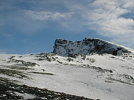
175:
576:
336:
297:
313:
a viewpoint 3,100 metres above sea level. In summer it is a relatively easy walk up to the summit from there.
533:
351:
286:
234:
212:
324:
463:
433:
405:
378:
282:
517:
505:
377:(Map) (La Alpujarra Marquesado del Zenete ed.). 1:40000. Editorial Penibetica. 2005.
227:
560:
300:. The access road that takes one to approximately 10 metres below the summit is the
474:
246:
316:
The Corral de la Veleta or Corral del Veleta glacier, at 37° N the southernmost
305:
80:
67:
216:
266:
28:
317:
293:
254:
327:
is located on the slopes of Pico Veleta, at an elevation of 2920 m.
44:
513:
404:(Map). 1:40000. Mapa Excursionista. Editorial Alpina. 2006–2007 .
265:
220:
432:(2nd ed.). Milnthorpe, Cumbria: Cicerone. p. 185.
521:
245:
240:
226:
208:
96:
57:
43:
38:
21:
308:. This road was built before the creation of the
304:across the mountains from Granada to the western
347:List of highest paved roads in Europe by country
277:(from the Arab word "Balata", meaning cliff) or
541:
8:
296:. Veleta's northern slopes are home to the
548:
534:
292:The mountain can be seen from the city of
18:
475:Veleta or Pico de Veleta - Iberianature
363:
464:Microbus services in the Sierra Nevada
342:List of highest paved roads in Europe
7:
502:
500:
423:
421:
396:
394:
369:
367:
520:. You can help Knowledge (XXG) by
453:Junta de Andalucia - Sierra Nevada
14:
281:is the third highest peak of the
504:
375:Parque Nacional de Sierra Nevada
320:in Europe, disappeared in 1913.
181:
174:
148:
141:
115:
108:
27:
132:Show map of Province of Granada
285:and the second highest of the
182:
149:
116:
51:3,396 m (11,142 ft)
49:3,394 m (11,135 ft)
1:
53:3,398 m (11,148 ft)
430:Walking in the Sierra Nevada
302:highest paved road in Europe
310:Sierra Nevada National Park
603:
499:
490:Profile on climbbybike.com
402:Sierra Nevada La Alpujarra
16:Mountain in Granada, Spain
337:Sierra Nevada Ski Station
298:Sierra Nevada Ski Station
270:The mountain and ski area
260:
101:
26:
572:Baetic three-thousanders
428:Walmsley, Andy (2006).
352:List of mountain passes
582:Mountains of Andalusia
516:location article is a
271:
587:Spain geography stubs
567:Sierra Nevada (Spain)
269:
165:Show map of Andalusia
495:El Corral del Veleta
81:37.05667°N 3.36583°W
33:The summit of Veleta
213:Province of Granada
77: /
325:IRAM 30m telescope
272:
162:Veleta (Andalusia)
86:37.05667; -3.36583
39:Highest point
577:Penibaetic System
529:
528:
283:Iberian Peninsula
264:
263:
198:Show map of Spain
129:Location in Spain
594:
550:
543:
536:
508:
501:
477:
472:
466:
461:
455:
450:
444:
443:
425:
416:
415:
398:
389:
388:
371:
249:
230:
199:
185:
184:
178:
166:
152:
151:
145:
133:
119:
118:
112:
92:
91:
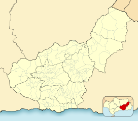
89:
88:
87:
82:
78:
75:
74:
73:
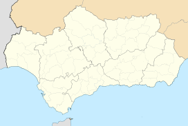
70:
31:
19:
602:
601:
597:
596:
595:
593:
592:
591:
557:
556:
555:
554:
486:
481:
480:
473:
469:
462:
458:
451:
447:
440:
427:
426:
419:
412:
400:
399:
392:
385:
373:
372:
365:
360:
333:
279:Pico del Veleta
247:
228:
204:
203:
202:
201:
200:
197:
196:
193:
192:
191:
190:
186:
169:
168:
167:
164:
163:
160:
159:
158:
157:
153:
136:
135:
134:
131:
130:
127:
126:
125:
124:
120:
85:
83:
79:
76:
71:
68:
66:
64:
63:
52:
50:
34:
17:
12:
11:
5:
600:
598:
590:
589:
584:
579:
574:
569:
559:
558:
553:
552:
545:
538:
530:
527:
526:
509:
498:
497:
492:
485:
484:External links
482:
479:
478:
467:
456:
445:
438:
417:
410:
390:
383:
362:
361:
359:
356:
355:
354:
349:
344:
339:
332:
329:
262:
261:
258:
257:
251:
243:
242:
238:
237:
232:
224:
223:
210:
206:
205:
195:Veleta (Spain)
194:
188:
187:
180:
179:
173:
172:
171:
170:
161:
155:
154:
147:
146:
140:
139:
138:
137:
128:
122:
121:
114:
113:
107:
106:
105:
104:
103:
102:
99:
98:
94:
93:
61:
55:
54:
47:
41:
40:
36:
35:
32:
24:
23:
15:
13:
10:
9:
6:
4:
3:
2:
599:
588:
585:
583:
580:
578:
575:
573:
570:
568:
565:
564:
562:
551:
546:
544:
539:
537:
532:
531:
525:
523:
519:
515:
510:
507:
503:
496:
493:
491:
488:
487:
483:
476:
471:
468:
465:
460:
457:
454:
449:
446:
441:
439:1-85284-435-3
435:
431:
424:
422:
418:
413:
411:84-8090-255-8
407:
403:
397:
395:
391:
386:
384:84-933461-9-5
380:
376:
370:
368:
364:
357:
353:
350:
348:
345:
343:
340:
338:
335:
334:
330:
328:
326:
321:
319:
314:
311:
307:
303:
299:
295:
290:
288:
287:Sierra Nevada
284:
280:
276:
268:
259:
256:
252:
250:
248:Easiest route
244:
239:
236:
235:Sierra Nevada
233:
231:
225:
222:
218:
214:
211:
207:
177:
144:
111:
100:
95:
90:
62:
60:
56:
48:
46:
42:
37:
30:
25:
20:
522:expanding it
511:
470:
459:
448:
429:
401:
374:
322:
315:
291:
278:
274:
273:
229:Parent range
84: /
59:Coordinates
561:Categories
358:References
306:Alpujarras
217:Andalucia
97:Geography
72:3°21′57″W
69:37°3′24″N
45:Elevation
331:See also
241:Climbing
209:Location
318:glacier
294:Granada
255:Granada
436:
408:
381:
275:Veleta
189:Veleta
156:Veleta
123:Veleta
22:Veleta
514:Spain
512:This
253:From
221:Spain
518:stub
434:ISBN
406:ISBN
379:ISBN
323:The
563::
420:^
393:^
366:^
219:,
215:,
549:e
542:t
535:v
524:.
442:.
414:.
387:.
Text is available under the Creative Commons Attribution-ShareAlike License. Additional terms may apply.