56:
304:
312:
40:
376:
540:. A meltwater stream that flows west from Victoria Lower Glacier into Lake Vida. Named by US-ACAN after James Stephen Kite, University of Maine, geological field assistant with the Victoria Valley party, 1977-78. In the course of field search for meteorites, Kite found a 43-pound meteorite iron in a moraine 0.3 nautical miles (0.56 km; 0.35 mi) inland from Victoria Lower Glacier.
549:
630:. An upland valley on the northeast side of Mount Booth in east Olympus Range. The valley opens north to Victoria Valley. Named by US-ACAN (2004) after Kenneth W. Murphy, Jr., United States Geological Survey (USGS) cartographic technician, a member of United States Geological Survey (USGS) satellite surveying teams at the South Pole Station during two winters, 1981 and 1987.
63:
1269:
1119:
668:. An upland valley on the west side of Mount Cerberus in east Olympus Range. The valley opens north to Victoria Valley. Named by US-ACAN (2004) after Michael C. Malin, Department of Geology, Arizona State University; United States Antarctic Project (USAP) abrasion rate observations in the McMurdo Dry Valleys, 1983-84 to 1993-94.
825:. Glacier between Mount Theseus and Mount Alien, occupying a low pass in the east part of the Olympus Range. Named by the VUWAE, 1958–59, for Professor R.H. Clark, head of the Geology Dept., Victoria University of Wellington, who was immediately responsible for the sponsoring of the expedition.
501:
in Saint Johns Range. The valley opens south to
Victoria Valley. Named by US-ACAN (2005) after Terry Deshler, Department of Atmospheric Science, University of Wyoming, Laramie, WY; United States Antarctic Project (USAP) investigations addressing quantitative ozone loss and related research, 13
787:. A meltwater lake that is circumscribed on the northwest and northeast sides by Robertson Ridge and Clark Glacier. Named by US-ACAN for Robert H. Thomas who participated in United States ArmyRP studies of the surface glaciology of the Ross Ice Shelf in the 1973–74 and 1974-75 seasons.
244:, below which Lake Vida lies across the valley. The valley continues in an east-northeast direction. The Packard Glacier descends part way into it from the north and the Clark Glacier extends part way into it from the south. At the foot of the valley Victoria Lower Glacier flows into the
901:. Glacier occupying the lower eastern end of Victoria Valley where it appears to merge with Wilson Piedmont Glacier. Named by the Victoria University of Wellington Antarctic Expedition (1958–59) for their Alma Mater, which sponsored the expedition.
1273:
1123:
362:
with an area of about 15 square nautical miles (51 km; 20 sq mi) at the head of
Victoria Upper Glacier. The névé lies between Clare Range and Cruzen Range eastward of The Fortress. Named by United States
863:. Ice-filled valley in the Saint Johns Range, lying northwest of Pond Peak. Named by US-ACAN for Russel R. Baldwin, United States Navy, who was in charge of the Airfield Maintenance Branch at McMurdo Station in 1962.
319:
Features of the
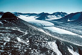
Victoria Valley, from its head to its foot, include Victoria Upper Glacier, Victoria Upper Lake, Lake Vida, Packard Glacier, Clark Glacier, Victoria Lower Glacier, Baldwin Valley and Staeffler Ridge.
748:
in the Saint Johns Range, flowing south into
Victoria Valley. Mapped and named by the VUWAE, 1958–59, for Andrew Packard, summer biologist who worked in this area with the N.Z. party of the CTAE in 1957-58.
417:. Glacier occupying the upper northwest end of Victoria Valley. Named by the Victoria University of Wellington Antarctic Expedition (VUWAE: 1958-59) for their Alma Mater which sponsored the expedition.
201:
455:. A meltwater lake at the terminus of Victoria Upper Glacier. Named for its position at the terminus of the glacier by American geologist Parker E. Calkin, in 1964.
98:
592:. A lake lying north of Mount Cerberus in the Victoria Valley. Named by the VUWAE (1958–59) after Vida (Vaida), a sledge dog of the BrAE, 1910-13.
1259:
1206:
1185:
1164:
1127:
364:
147:
184:) is an extensive ice-free valley, formerly occupied by a large glacier, extending from Victoria Upper Glacier to Victoria Lower Glacier in
55:
1250:
1197:
1176:
1155:
1245:
1192:
1171:
1150:
1292:
205:
1277:
1255:
1202:
1181:
1160:
706:. An upland valley between Mount Cerberus and Euros Ridge in east Olympus Range. The valley opens north to Victoria Valley.
602:
465:
640:
512:
678:
330:
1297:
91:
873:
835:
797:
759:
716:
564:
427:
389:
265:
245:
292:
287:
380:
303:
217:
189:
1134:
282:
311:
225:
220:. The head of the Victoria Valley, which contains the Victoria Upper Glacier, is south of the
1229:
241:
39:
1213:
745:
375:
233:
1286:
185:
1101:
229:
17:
548:
237:
221:
277:
498:
494:
75:
888:
875:
850:
837:
812:
799:
774:
761:
731:
718:
693:
680:
655:
642:
617:
604:
579:
566:
527:
514:
480:
467:
442:
429:
404:
391:
359:
345:
332:
163:
149:
114:
100:
557:
249:
547:
374:
310:
302:
367:(US-ACAN) (2005) in association with Victoria Upper Glacier.
923:
921:
919:
917:
915:
913:
307:
Upper
Victoria Valley towards the north of mapped region
202:
Victoria
University of Wellington Antarctic Expedition
1109:(2 ed.), United States Board on Geographic Names
975:
90:
85:
32:
1035:
232:to the west. It is joined from the west by the
987:
951:
1011:
224:. The valley descends south-southeast between
44:Victoria Upper Glacier in Victoria Valley 1958
1023:
8:
963:
248:, which extends along the west coast of the
29:
379:Victoria Upper Glacier, Victoria Valley,
1260:United States Department of the Interior
1207:United States Department of the Interior
1186:United States Department of the Interior
1165:United States Department of the Interior
1139:, AADC: Australian Antarctic Data Centre
204:(VUWAE: 1958-59) after their Alma Mater
1234:, USGS: United States Geological Survey
1218:, USGS: United States Geological Survey
1128:United States Board on Geographic Names
1083:
1071:
1059:
1047:
999:
939:
927:
909:
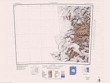
315:Lower Victoria Valley towards the north
62:
188:, Antarctica. It is one of the larger
365:Advisory Committee on Antarctic Names
7:
1251:Geographic Names Information System
1198:Geographic Names Information System
1177:Geographic Names Information System
1156:Geographic Names Information System
493:. A mostly ice-free valley between
1276:from websites or documents of the
1126:from websites or documents of the
216:The Victoria Valley is one of the
25:
1103:Geographic Names of the Antarctic
206:Victoria University of Wellington
200:Victoria Valley was named by the
1272: This article incorporates
1267:
1122: This article incorporates
1117:
208:which sponsored the expedition.
61:
54:
38:
1278:United States Geological Survey
1256:United States Geological Survey
1203:United States Geological Survey
1182:United States Geological Survey
1161:United States Geological Survey
1100:Alberts, Fred G., ed. (1995),
1:
293:GPX (secondary coordinates)
1314:
555:
502:field seasons 1990-2004.
288:GPX (primary coordinates)
263:Map all coordinates using
49:
37:
1293:Valleys of Victoria Land
976:Victoria Upper Névé USGS
744:. Glacier just west of
618:77.428821°S 161.792704°E
481:77.320771°S 161.755235°E
271:Download coordinates as:
656:77.43133°S 161.849729°E
528:77.385244°S 162.08523°E
246:Wilson Piedmont Glacier
1274:public domain material
1124:public domain material
867:Victoria Lower Glacier
694:77.43476°S 161.94354°E
623:-77.428821; 161.792704
553:
486:-77.320771; 161.755235
384:
371:Victoria Upper Glacier
346:77.26775°S 161.09418°E
316:
308:
1246:"Victoria Upper Névé"
661:-77.43133; 161.849729
551:
533:-77.385244; 162.08523
378:
314:
306:
283:GPX (all coordinates)
1036:Cerberus Valley AADC
699:-77.43476; 161.94354
351:-77.26775; 161.09418
236:, and then south of
228:to the east and the
27:Valley in Antarctica
1298:McMurdo Dry Valleys
988:Deshler Valley USGS
952:Taylor Glacier USGS
885: /
847: /
809: /
771: /
728: /
690: /
652: /
614: /
576: /
524: /
477: /
439: /
421:Victoria Upper Lake
401: /
381:McMurdo Dry Valleys
342: /
324:Victoria Upper Névé
218:McMurdo Dry Valleys
190:McMurdo Dry Valleys
159: /
110: /
18:Victoria Upper Névé
1012:Murphy Valley USGS
889:77.300°S 162.667°E
851:77.300°S 162.333°E
813:77.417°S 162.417°E
775:77.400°S 162.250°E
732:77.350°S 162.167°E
580:77.383°S 161.950°E
554:
443:77.317°S 161.583°E
405:77.267°S 161.417°E
385:
317:
309:
164:77.383°S 161.933°E
115:77.383°S 161.933°E
1024:Malin Valley USGS
226:Saint Johns Range
139:
138:
16:(Redirected from
1305:
1271:
1270:
1262:
1241:
1240:
1239:
1225:
1224:
1223:
1209:
1188:
1167:
1151:"Deshler Valley"
1146:
1145:
1144:
1121:
1120:
1116:
1115:
1114:
1108:
1087:
1081:
1075:
1069:
1063:
1057:
1051:
1045:
1039:
1033:
1027:
1021:
1015:
1009:
1003:
997:
991:
985:
979:
973:
967:
964:Ross Island USGS
961:
955:
949:
943:
937:
931:
925:
900:
899:
897:
896:
895:
894:-77.300; 162.667
890:
886:
883:
882:
881:
878:
862:
861:
859:
858:
857:
856:-77.300; 162.333
852:
848:
845:
844:
843:
840:
824:
823:
821:
820:
819:
818:-77.417; 162.417
814:
810:
807:
806:
805:
802:
786:
785:
783:
782:
781:
780:-77.400; 162.250
776:
772:
769:
768:
767:
764:
743:
742:
740:
739:
738:
737:-77.350; 162.167
733:
729:
726:
725:
724:
721:
705:
704:
702:
701:
700:
695:
691:
688:
687:
686:
683:
667:
666:
664:
663:
662:
657:
653:
650:
649:
648:
645:
629:
628:
626:
625:
624:
619:
615:
612:
611:
610:
607:
591:
590:
588:
587:
586:
585:-77.383; 161.950
581:
577:
574:
573:
572:
569:
539:
538:
536:
535:
534:
529:
525:
522:
521:
520:
517:
492:
491:
489:
488:
487:
482:
478:
475:
474:
473:
470:
454:
453:
451:
450:
449:
448:-77.317; 161.583
444:
440:
437:
436:
435:
432:
416:
415:
413:
412:
411:
410:-77.267; 161.417
406:
402:
399:
398:
397:
394:
357:
356:
354:
353:
352:
347:
343:
340:
339:
338:
335:
183:
182:
180:
179:
178:
176:
171:
170:
169:-77.383; 161.933
165:
160:
157:
156:
155:
152:
134:
133:
131:
130:
129:
127:
122:
121:
120:-77.383; 161.933
116:
111:
108:
107:
106:
103:
65:
64:
58:
42:
30:
21:
1313:
1312:
1308:
1307:
1306:
1304:
1303:
1302:
1283:
1282:
1268:
1265:
1244:
1237:
1235:
1228:
1221:
1219:
1212:
1193:"Murphy Valley"
1191:
1170:
1149:
1142:
1140:
1136:Cerberus Valley
1133:
1118:
1112:
1110:
1106:
1099:
1095:
1090:
1082:
1078:
1070:
1066:
1058:
1054:
1046:
1042:
1034:
1030:
1022:
1018:
1010:
1006:
998:
994:
986:
982:
974:
970:
962:
958:
950:
946:
938:
934:
926:
911:
907:
893:
891:
887:
884:
879:
876:
874:
872:
871:
869:
855:
853:
849:
846:
841:
838:
836:
834:
833:
831:
817:
815:
811:
808:
803:
800:
798:
796:
795:
793:
779:
777:
773:
770:
765:
762:
760:
758:
757:
755:
736:
734:
730:
727:
722:
719:
717:
715:
714:
712:
710:Packard Glacier
698:
696:
692:
689:
684:
681:
679:
677:
676:
674:
672:Cerberus Valley
660:
658:
654:
651:
646:
643:
641:
639:
638:
636:
622:
620:
616:
613:
608:
605:
603:
601:
600:
598:
584:
582:
578:
575:
570:
567:
565:
563:
562:
560:
546:
532:
530:
526:
523:
518:
515:
513:
511:
510:
508:
485:
483:
479:
476:
471:
468:
466:
464:
463:
461:
447:
445:
441:
438:
433:
430:
428:
426:
425:
423:
409:
407:
403:
400:
395:
392:
390:
388:
387:
373:
350:
348:
344:
341:
336:
333:
331:
329:
328:
326:
301:
300:
299:
298:
297:
258:
242:McKelvey Valley
214:
198:
175:Victoria Valley
174:
172:
168:
166:
162:
161:
158:
153:
150:
148:
146:
145:
142:Victoria Valley
126:Victoria Valley
125:
123:
119:
117:
113:
112:
109:
104:
101:
99:
97:
96:
81:
80:
79:
78:
73:
72:
71:
70:
69:Victoria Valley
66:
45:
33:Victoria Valley
28:
23:
22:
15:
12:
11:
5:
1311:
1309:
1301:
1300:
1295:
1285:
1284:
1264:
1263:
1242:
1231:Taylor Glacier
1226:
1210:
1189:
1172:"Malin Valley"
1168:
1147:
1131:
1096:
1094:
1091:
1089:
1088:
1076:
1074:, p. 138.
1064:
1062:, p. 742.
1052:
1050:, p. 552.
1040:
1028:
1016:
1004:
1002:, p. 395.
992:
980:
968:
956:
944:
942:, p. 480.
932:
930:, p. 783.
908:
906:
903:
868:
865:
830:
829:Baldwin Valley
827:
792:
789:
754:
751:
746:Purgatory Peak
711:
708:
673:
670:
635:
632:
597:
594:
556:Main article:
545:
542:
507:
504:
460:
459:Deshler Valley
457:
422:
419:
372:
369:
325:
322:
296:
295:
290:
285:
280:
274:
268:
261:
260:
259:
257:
254:
234:Barwick Valley
213:
210:
197:
194:
137:
136:
94:
88:
87:
83:
82:
74:
68:
67:
60:
59:
53:
52:
51:
50:
47:
46:
43:
35:
34:
26:
24:
14:
13:
10:
9:
6:
4:
3:
2:
1310:
1299:
1296:
1294:
1291:
1290:
1288:
1281:
1279:
1275:
1261:
1257:
1253:
1252:
1247:
1243:
1233:
1232:
1227:
1217:
1216:
1211:
1208:
1204:
1200:
1199:
1194:
1190:
1187:
1183:
1179:
1178:
1173:
1169:
1166:
1162:
1158:
1157:
1152:
1148:
1138:
1137:
1132:
1129:
1125:
1105:
1104:
1098:
1097:
1092:
1086:, p. 42.
1085:
1080:
1077:
1073:
1068:
1065:
1061:
1056:
1053:
1049:
1044:
1041:
1037:
1032:
1029:
1025:
1020:
1017:
1013:
1008:
1005:
1001:
996:
993:
989:
984:
981:
977:
972:
969:
965:
960:
957:
953:
948:
945:
941:
936:
933:
929:
924:
922:
920:
918:
916:
914:
910:
904:
902:
898:
866:
864:
860:
828:
826:
822:
791:Clark Glacier
790:
788:
784:
752:
750:
747:
741:
709:
707:
703:
671:
669:
665:
633:
631:
627:
596:Murphy Valley
595:
593:
589:
559:
550:
543:
541:
537:
505:
503:
500:
496:
490:
458:
456:
452:
420:
418:
414:
382:
377:
370:
368:
366:
361:
355:
323:
321:
313:
305:
294:
291:
289:
286:
284:
281:
279:
276:
275:
273:
272:
267:
266:OpenStreetMap
264:
255:
253:
251:
247:
243:
239:
235:
231:
227:
223:
219:
211:
209:
207:
203:
195:
193:
191:
187:
186:Victoria Land
181:
143:
132:
95:
93:
89:
84:
77:
57:
48:
41:
36:
31:
19:
1266:
1249:
1236:, retrieved
1230:
1220:, retrieved
1214:
1196:
1175:
1154:
1141:, retrieved
1135:
1111:, retrieved
1102:
1084:Alberts 1995
1079:
1072:Alberts 1995
1067:
1060:Alberts 1995
1055:
1048:Alberts 1995
1043:
1031:
1019:
1007:
1000:Alberts 1995
995:
983:
971:
959:
947:
940:Alberts 1995
935:
928:Alberts 1995
870:
832:
794:
756:
713:
675:
637:
634:Malin Valley
599:
561:
509:
462:
424:
386:
383:, Antarctica
327:
318:
270:
269:
262:
230:Cruzen Range
215:
199:
141:
140:
1215:Ross Island
892: /
854: /
816: /
778: /
753:Lake Thomas
735: /
697: /
685:161°56′37″E
659: /
647:161°50′59″E
621: /
609:161°47′34″E
583: /
531: /
519:162°05′07″E
506:Kite Stream
484: /
472:161°45′19″E
446: /
408: /
349: /
337:161°05′39″E
238:Mount Insel
222:Clare Range
167: /
118: /
92:Coordinates
1287:Categories
1238:2024-02-13
1222:2024-02-13
1143:2024-02-20
1113:2024-01-30
905:References
682:77°26′05″S
644:77°25′53″S
606:77°25′44″S
516:77°23′07″S
499:Morse Spur
495:Spain Peak
469:77°19′15″S
334:77°16′04″S
173: (
124: (
76:Antarctica
558:Lake Vida
552:Lake Vida
544:Lake Vida
86:Geography
880:162°40′E
842:162°20′E
804:162°25′E
766:162°15′E
723:162°10′E
571:161°57′E
434:161°35′E
396:161°25′E
256:Features
250:Ross Sea
212:Location
154:161°56′E
105:161°56′E
1093:Sources
877:77°18′S
839:77°18′S
801:77°25′S
763:77°24′S
720:77°21′S
568:77°23′S
431:77°19′S
393:77°16′S
240:by the
151:77°23′S
135:
102:77°23′S
358:,}. A
1107:(PDF)
497:and
360:névé
196:Name
278:KML
1289::
1280:.
1258:,
1254:,
1248:,
1205:,
1201:,
1195:,
1184:,
1180:,
1174:,
1163:,
1159:,
1153:,
912:^
252:.
192:.
1130:.
1038:.
1026:.
1014:.
990:.
978:.
966:.
954:.
177:)
144:(
128:)
20:)
Text is available under the Creative Commons Attribution-ShareAlike License. Additional terms may apply.