729:
29:
175:. They used to be spelled according to a mainly Spanish-based orthography which is incompatible with the normalized spellings of these languages and Law 29735 which regulates the 'use, preservation, development, recovery, promotion and diffusion of the originary languages of Peru'. According to Article 20 of
179:(Supreme Decree) which approves the Regulations to Law 29735, published in the official newspaper El Peruano on July 22, 2016, adequate spellings of the toponyms in the normalized alphabets of the indigenous languages must progressively be proposed with the aim of standardizing the namings used by the
632:
s. Hist. Idolo de este nombre. Icono o imagen que representaba la divinidad tutelar del valle que se extiende desde lo que hoy es La Raya –línea divisoria entre Cusco y Puno– hasta la montaña misma. (J.L.P.) || Apellido de origen
557:"Decreto Supremo que aprueba el Reglamento de la Ley N° 29735, Ley que regula el uso, preservación, desarrollo, recuperación, fomento y difusión de las lenguas originarias del Perú, Decreto Supremo N° 004-2016-MC"
556:
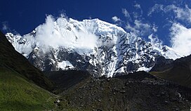
163:. It extends between 13°10' and 13°27'S. and 72°30' and 73°15'W for about 85 km. Its highest peak is Salcantay, which is 6,271 m (20,574 ft) above sea level.
797:
773:
591:
El campo o todo lo que está fuera del pueblo, ahora sea cuesta, ahora llano. +Todo lo bajo respecto de la mesa o poyo, la tierra llana.
528:
656:
Mariko Namba Walter,Eva Jane
Neumann Fridman, Shamanism: An Encyclopedia of World Beliefs, Practices, and Culture, Vol. 1, p. 439
792:
802:
479:
316:
766:
615:
s. Campo. Lugar generalmente plano. Pampa. / s. Llanura. Terreno uniforme y dilatado, sin altos ni bajos pronunciados.
624:
Diccionario
Quechua - Español - Quechua, Academía Mayor de la Lengua Quechua, Gobierno Regional Cusco, Cusco 2005:
394:
601:
Teofilo Laime
Ajacopa, Diccionario Bilingüe Iskay simipi yuyayk'ancha, La Paz, 2007 (Quechua-Spanish dictionary):
711:
Conny
Amelunxen, South America, Peru, Cordillera Vilcabamba, Pumasillo Group, Multiple Ascents, AAC publications,
156:
457:
759:
576:
Ludovico
Bertonio, Transcripción del vocabulario de la lengua aymara (Spanish-Aymara dictionary):
702:
escale.minedu.gob.pe - UGEL map of the La
Convención Province and Urubamba Province (Cusco Region)
584:
Adoratorio dedicado al Sol u otros ídolos. / El Sol como antiguamente decían y ahora dicen inti.
334:
172:
524:
358:
340:
328:
160:
743:
439:
346:
298:
262:
223:
292:
219:
91:
286:
121:
786:
406:
388:
274:
152:
506:
144:
421:
376:
364:
28:
728:
433:
427:
415:
352:
739:
256:
250:
242:
207:
382:
280:
310:
322:
304:
52:
245:
at 6,271 metres (20,574 ft). Other mountains are listed below:
370:
268:
128:
736:
148:
187:
realizes the necessary changes in the official maps of Peru.
747:
685:
Centenary edition. New York:Sterling Publ. Co. p.155. (
120:
112:
104:
99:
79:
74:
66:
61:
51:
43:
38:
21:
190:Hints to wrong spellings are terms containing
171:Most of the names in the range originate from
767:
8:
83:
448:Khallkaqucha, 4,464 m (14,646 ft)
774:
760:
18:
403:Pitupaccha, 5,082 m (16,673 ft)
229:: a species of tree, or a local God; and
445:Qiwiñayuq, 4,547 m (14,918 ft)
412:Yanacocha, 4,920 m (16,140 ft)
218:The name Vilcabamba possibly comes from
611:/ s. Dios menor en la teogonia incaica.
546:Jill Neate, Mountaineering in the Andes
471:
451:Yanaorjo, 4,460 m (14,630 ft)
400:Yanajaja, 5,093 m (16,709 ft)
454:Yanama, 4,415 m (14,485 ft)
7:
725:
723:
542:
540:
502:
500:
746:. You can help Knowledge (XXG) by
206:), "e", "o", "ca", "cu", "qu" or
14:
609:s. Nieto, ta respecto del abuelo.
241:The highest peak in the range is
727:
27:
798:Mountain ranges of Cusco Region
521:The Andes: A Guide for Climbers
460:, 4,315 m (14,157 ft)
442:, 4,601 m (15,095 ft)
436:, 4,728 m (15,512 ft)
430:, 4,800 m (15,700 ft)
424:, 4,800 m (15,700 ft)
418:, 4,900 m (16,100 ft)
409:, 4,932 m (16,181 ft)
397:, 5,100 m (16,700 ft)
391:, 5,108 m (16,759 ft)
379:, 5,152 m (16,903 ft)
361:, 5,210 m (17,090 ft)
355:, 5,239 m (17,188 ft)
349:, 5,265 m (17,274 ft)
343:, 5,269 m (17,287 ft)
337:, 5,297 m (17,379 ft)
331:, 5,338 m (17,513 ft)
325:, 5,347 m (17,543 ft)
319:, 5,404 m (17,730 ft)
313:, 5,418 m (17,776 ft)
307:, 5,422 m (17,789 ft)
301:, 5,428 m (17,808 ft)
295:, 5,450 m (17,880 ft)
277:, 5,520 m (18,110 ft)
271:, 5,667 m (18,593 ft)
265:, 5,771 m (18,934 ft)
259:, 5,928 m (19,449 ft)
253:, 5,991 m (19,656 ft)
70:85 km (53 mi) N-S
177:Decreto Supremo No 004-2016-MC
1:
484:Inventario Turistico del Perú
385:5,126 m (16,818 ft)
373:5,175 m (16,978 ft)
367:5,176 m (16,982 ft)
289:5,464 m (17,927 ft)
283:5,473 m (17,956 ft)
57:6,271 m (20,574 ft)
143:is located in the region of
683:The Lost City of the Incas.
681:Bingham, Hiram III. (2002)
645:adj. Sagrado, divino, sacro
523:. Andes. pp. 109–112.
819:
722:
509:USGS, Peruvian Cordilleras
480:"Cordillera de Vilcabamba"
85:Willka Pampa / Willkapampa
26:
22:Vilcabamba mountain range
793:Mountain ranges of Peru
670:Anadenanthera colubrina
666:Anadenanthera peregrina
637:s. Biznieto o biznieta.
233:: flat terrain, plain.
151:, in the provinces of
84:
16:Mountain range in Peru
519:Biggar, John (2005).
803:Peru geography stubs
693:a lowland flat area)
689:a type of tree and
39:Highest point
755:
754:
639:SINÓN: haway. ||
134:
133:
810:
776:
769:
762:
731:
724:
712:
709:
703:
700:
694:
679:
673:
654:
648:
622:
616:
599:
593:
574:
568:
567:
565:
563:
553:
547:
544:
535:
534:
516:
510:
504:
495:
494:
492:
491:
476:
440:Jatun Huamanripa
124:
95:
87:
31:
19:
818:
817:
813:
812:
811:
809:
808:
807:
783:
782:
781:
780:
720:
716:
715:
710:
706:
701:
697:
680:
676:
655:
651:
623:
619:
600:
596:
575:
571:
561:
559:
555:
554:
550:
545:
538:
531:
518:
517:
513:
505:
498:
489:
487:
478:
477:
473:
468:
463:
317:Corihuayrachina
239:
216:
169:
122:
89:
34:
17:
12:
11:
5:
816:
814:
806:
805:
800:
795:
785:
784:
779:
778:
771:
764:
756:
753:
752:
732:
714:
713:
704:
695:
674:
649:
617:
594:
569:
548:
536:
529:
511:
496:
470:
469:
467:
464:
462:
461:
455:
452:
449:
446:
443:
437:
431:
425:
419:
413:
410:
404:
401:
398:
392:
386:
380:
374:
368:
362:
356:
350:
344:
338:
332:
326:
320:
314:
308:
302:
296:
290:
284:
278:
272:
266:
260:
254:
247:
238:
235:
215:
212:
210:among others.
168:
165:
141:mountain range
132:
131:
126:
118:
117:
114:
110:
109:
106:
102:
101:
97:
96:
81:
77:
76:
72:
71:
68:
64:
63:
59:
58:
55:
49:
48:
45:
41:
40:
36:
35:
32:
24:
23:
15:
13:
10:
9:
6:
4:
3:
2:
815:
804:
801:
799:
796:
794:
791:
790:
788:
777:
772:
770:
765:
763:
758:
757:
751:
749:
745:
742:article is a
741:
738:
733:
730:
726:
721:
718:
708:
705:
699:
696:
692:
688:
684:
678:
675:
671:
667:
663:
659:
653:
650:
646:
642:
638:
634:
629:
628:
621:
618:
614:
610:
606:
605:
598:
595:
592:
588:
585:
581:
580:
573:
570:
558:
552:
549:
543:
541:
537:
532:
530:9780953608720
526:
522:
515:
512:
508:
503:
501:
497:
485:
481:
475:
472:
465:
459:
456:
453:
450:
447:
444:
441:
438:
435:
432:
429:
426:
423:
420:
417:
414:
411:
408:
405:
402:
399:
396:
393:
390:
387:
384:
381:
378:
375:
372:
369:
366:
363:
360:
357:
354:
351:
348:
345:
342:
339:
336:
333:
330:
327:
324:
321:
318:
315:
312:
309:
306:
303:
300:
297:
294:
291:
288:
285:
282:
279:
276:
275:Choquetacarpo
273:
270:
267:
264:
261:
258:
255:
252:
249:
248:
246:
244:
236:
234:
232:
228:
225:
221:
213:
211:
209:
205:
201:
197:
193:
188:
186:
182:
178:
174:
166:
164:
162:
158:
157:La Convención
154:
150:
146:
142:
139:
130:
127:
125:
119:
115:
111:
107:
103:
98:
93:
86:
82:
78:
73:
69:
65:
60:
56:
54:
50:
46:
42:
37:
30:
25:
20:
748:expanding it
734:
719:
717:
707:
698:
690:
686:
682:
677:
669:
665:
661:
657:
652:
644:
640:
636:
631:
626:
625:
620:
612:
608:
603:
602:
597:
590:
586:
583:
578:
577:
572:
560:. Retrieved
551:
520:
514:
488:. Retrieved
483:
474:
240:
230:
226:
217:
203:
199:
198:(instead of
195:
191:
189:
184:
180:
176:
170:
140:
137:
135:
123:Parent range
116:Cusco Region
422:Chuchaujasa
377:Choquesafra
365:Coisopacana
80:Native name
787:Categories
562:August 18,
490:2016-07-18
486:. MINCETUR
466:References
434:Llamahuasi
428:Mandorcasa
416:Quenuaorco
407:Nañuhuaico
353:Chaupimayo
335:Soirococha
208:diphthongs
138:Vilcabamba
62:Dimensions
740:geography
458:Incahuasi
395:Pumasillo
341:Azulcocha
329:Jatunjasa
257:Tucarhuay
251:Pumasillo
243:Salcantay
237:Mountains
214:Etymology
100:Geography
53:Elevation
47:Salcantay
33:Salcantay
737:Peruvian
633:inkaico.
507:usgs.gov
383:Ocobamba
293:Pucapuca
287:Huayanay
281:Humantay
263:Padreyoc
167:Toponyms
161:Urubamba
641:Linaje.
311:Amparay
224:Quechua
173:Quechua
105:Country
687:huilca
658:willka
627:willka
604:willka
579:Willka
527:
359:Paccha
323:Yanama
305:Paljay
227:willka
220:Aymara
183:. The
113:Region
92:Aymara
88:
75:Naming
67:Length
735:This
691:pampa
662:vilca
613:pampa
587:Pampa
389:Cayco
371:Moyoc
347:Kaiko
299:Soray
269:Panta
231:pampa
145:Cusco
129:Andes
744:stub
668:and
564:2017
525:ISBN
222:and
202:and
194:and
159:and
153:Anta
149:Peru
136:The
108:Peru
44:Peak
660:or
643:||
196:hui
192:hua
185:IGN
181:IGN
789::
672:):
635:/
630:-
607:-
589:-
582:-
539:^
499:^
482:.
204:wi
200:wa
155:,
147:,
775:e
768:t
761:v
750:.
664:(
647:.
566:.
533:.
493:.
94:)
90:(
Text is available under the Creative Commons Attribution-ShareAlike License. Additional terms may apply.