447:
419:
47:
29:
435:
54:
559:
257:
There are two Virgin
Valleys in Nevada. This article is mostly about the Southern valley, which is Northeast of Las Vegas along I-15. The Northern valley is on the opposite end of the State near the Oregon border. The two valleys are approximately 600 miles apart. The Opal mines are located in
273:. She became known as the "Opal Queen" owning the Rainbow, Stonetree and Bonanza mines and the "Giant Tree" Opal Claim. She sold the latter in about 1918 and concentrated on the Rainbow and Bonanza mines.
418:
589:
331:
The Virgin Valley is vertically bisected, north-south by the Nevada-Arizona border. The downstream Nevada half of the valley has the very beginnings of
594:
446:
525:
46:
232:
152:
127:
379:
344:
145:
579:
584:
294:
270:
301:
269:
who had been a writer and a farmer but bought a string of claims after being sent to do a story for the
266:
474:
338:
282:
228:
123:
109:
574:
490:
325:
224:
553:
521:
515:
434:
28:
425:
373:
321:
290:
236:
132:
113:
281:
The Virgin Valley is about 25 miles (40 km) long. Upstream in the valley's northeast,
289:, as well as two outfalls from two washes that flow south from the Beaver Dam Mountains.
313:
568:
217:
66:
320:, the southwest border of Virgin Valley. Mormon Mesa is an extension south from the
246:
209:
188:
297:, about 10 miles (16 km). Mesquite is the approximate center of the valley.
317:
305:
137:
394:
381:
359:
346:
335:, about 20 miles (32 km) upstream, where the Virgin River used to flow.
167:
154:
332:
309:
304:
are southeast of the Virgin Valley and
Mountains, and separate the northern
242:
265:. The opals were discovered in about 1913. The richest mines were owned by
560:
Virgin River
Recreation Area, southwest Virgin Valley (on Riverside Road)
201:
74:
205:
70:
475:
https://travelnevada.com/mines-prospecting/bonanza-opal-mines-inc/
554:
Beaver Dam
Mountains Wilderness Trail, northeast of Virgin Valley
262:
213:
470:
478:
220:
region drain southwards into the Virgin River and Valley.
316:
arm. The area north of the South Virgin
Mountains is the
16:
Valley in Clark County, Nevada and Mohave County, Arizona
223:
The Virgin Valley begins as the Virgin River exits the
216:
and southeast Nevada; parts of
Arizona, especially the
184:
144:
119:
105:
100:
92:
84:
21:
249:extends slightly upstream into the Virgin Valley.
261:The Virgin Valley has mines that are rich in
8:
540:Arizona Road and Recreation Atlas, p. 26-27.
18:
520:. John Wiley & Sons. pp. 401–.
341:in the valley's northeast is located at
463:
414:
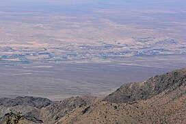
33:view of Mesquite, NV from Virgin Peak,
428:from Virgin Valley, south of Mesquite
376:in the valley's center is located at
53:
7:
212:. The Virgin River drains southwest
590:Landforms of Mohave County, Arizona
514:Allan W. Eckert (2 October 1997).
324:which are separated east from the
14:
445:
433:
417:
235:north, and the northeast of the
52:
45:
27:
595:Valleys of Clark County, Nevada
328:tributary to north Lake Mead.
285:is located at the exit of the
1:
452:valley downstream of Mesquite
239:on the south of the Gorge.
611:
491:"ABOUT DOMINION OPAL MINE"
471:https://www.nevadaopal.com
200:is a valley in northwest
40:
26:
479:https://royalpeacock.com
424:Virgin Peak, southwest
295:Interstate 15 in Nevada
271:San Francisco Chronicle
395:36.80250°N 114.08222°W
360:36.90000°N 113.93333°W
302:South Virgin Mountains
293:is downstream, and on
168:36.80250°N 114.08222°W
267:Flora Haines Loughead
258:the Northern valley.
96:12 miles (19 km)
88:25 miles (40 km)
558:Riverside, Arizona:
400:36.80250; -114.08222
365:36.90000; -113.93333
229:Beaver Dam Mountains
173:36.80250; -114.08222
124:Beaver Dam Mountains
495:DOMINION OPAL MINES
391: /
356: /
164: /
580:Valleys of Arizona
517:The World of Opals
326:Meadow Valley Wash
287:Virgin River Gorge
225:Virgin River Gorge
106:Population centers
35:(center of valley)
585:Valleys of Nevada
527:978-0-471-13397-1
194:
193:
602:
541:
538:
532:
531:
511:
505:
504:
502:
501:
487:
481:
468:
449:
437:
426:Virgin Mountains
421:
406:
405:
403:
402:
401:
396:
392:
389:
388:
387:
384:
371:
370:
368:
367:
366:
361:
357:
354:
353:
352:
349:
322:Mormon Mountains
237:Virgin Mountains
179:
178:
176:
175:
174:
169:
165:
162:
161:
160:
157:
133:Virgin Mountains
56:
55:
49:
31:
19:
610:
609:
605:
604:
603:
601:
600:
599:
565:
564:
550:
545:
544:
539:
535:
528:
513:
512:
508:
499:
497:
489:
488:
484:
469:
465:
460:
453:
450:
441:
438:
429:
422:
413:
399:
397:
393:
390:
385:
382:
380:
378:
377:
364:
362:
358:
355:
350:
347:
345:
343:
342:
339:Littlefield, AZ
283:Littlefield, AZ
279:
255:
172:
170:
166:
163:
158:
155:
153:
151:
150:
136:
131:
110:Littlefield, AZ
80:
79:
78:
77:
64:
63:
62:
61:
57:
36:
34:
17:
12:
11:
5:
608:
606:
598:
597:
592:
587:
582:
577:
567:
566:
563:
562:
556:
549:
548:External links
546:
543:
542:
533:
526:
506:
482:
462:
461:
459:
456:
455:
454:
451:
444:
442:
439:
432:
430:
423:
416:
412:
409:
314:Colorado River
278:
275:
254:
251:
204:and southeast
192:
191:
186:
182:
181:
148:
142:
141:
121:
117:
116:
107:
103:
102:
98:
97:
94:
90:
89:
86:
82:
81:
65:
59:
58:
51:
50:
44:
43:
42:
41:
38:
37:
32:
24:
23:
15:
13:
10:
9:
6:
4:
3:
2:
607:
596:
593:
591:
588:
586:
583:
581:
578:
576:
573:
572:
570:
561:
557:
555:
552:
551:
547:
537:
534:
529:
523:
519:
518:
510:
507:
496:
492:
486:
483:
480:
476:
472:
467:
464:
457:
448:
443:
436:
431:
427:
420:
415:
410:
408:
404:
375:
369:
340:
336:
334:
329:
327:
323:
319:
315:
311:
307:
303:
298:
296:
292:
288:
284:
276:
274:
272:
268:
264:
259:
252:
250:
248:
244:
240:
238:
234:
230:
226:
221:
219:
218:Arizona Strip
215:
211:
207:
203:
199:
198:Virgin Valley
190:
187:
183:
177:
149:
147:
143:
139:
134:
129:
125:
122:
118:
115:
111:
108:
104:
99:
95:
91:
87:
83:
76:
72:
68:
67:United States
60:Virgin Valley
48:
39:
30:
25:
22:Virgin Valley
20:
536:
516:
509:
498:. Retrieved
494:
485:
466:
374:Mesquite, NV
337:
330:
299:
291:Mesquite, NV
286:
280:
260:
256:
247:Virgin River
241:
227:between the
222:
210:Virgin River
197:
195:
189:Virgin River
114:Mesquite, NV
398: /
363: /
318:Mormon Mesa
306:Overton Arm
277:Description
171: /
146:Coordinates
138:Mormon Mesa
569:Categories
500:2017-07-25
458:References
386:114°4′56″W
351:113°56′0″W
233:Wilderness
159:114°4′56″W
135:-E & S
128:Wilderness
120:Borders on
575:Lake Mead
440:watershed
383:36°48′9″N
348:36°54′0″N
333:Lake Mead
312:from the
310:Lake Mead
243:Lake Mead
156:36°48′9″N
101:Geography
411:Gallery
253:History
245:on the
208:on the
202:Arizona
180:
75:Arizona
524:
206:Nevada
185:Rivers
126:&
85:Length
71:Nevada
263:opals
93:Width
522:ISBN
300:The
231:and
214:Utah
196:The
372:.
308:of
140:-SW
130:-NE
571::
493:.
477:,
473:,
407:.
112:,
69:,
530:.
503:.
73:/
Text is available under the Creative Commons Attribution-ShareAlike License. Additional terms may apply.