142:
135:
40:
652:
Pico de Tancítaro Flora and Fauna
Protection Area covers 23,405 ha, ranging from 2,200 to 3,840 meters in elevation. The area was designated a national park on 27 July 1940, and redesignated a flora and fauna protection area on 19 August 2009. It is still widely known as Pico de Tancítaro National
369:
Mountain mesophilic forest, or cloud forest, is found on slopes between 2000 and 2600 meters elevation with high year-round humidity and frequent fog, particularly in ravines which offer year-round water and protection from drying winds and sun. Typical trees include
727:"El Área de Protección de Flora y Fauna Pico de Tancítaro, proveedora de agua de al menos a 82 comunidades". Secretaría de Medio Ambiente y Recursos Naturales, Government of Mexico. Published 19 August 2018. Accessed 14 December 2020.
730:
766:
Paredes, Julián & Cervantes-Martínez, Rosalinda & Trucíos, Ramón. (2013). "Reconstruction of Severe
Droughts in "Pico de Tancíntaro" National Park, Michoacán". Revista Chapingo Serie Zonas Áridas. XII. 57-62.
813:
461:
Subalpine grasslands, known as
Zacatonal or zacatal, occur as low as 3000 meters elevation on outcrops of volcanic sandstone, and become predominant above 3400 meters elevation. Woodlands of
728:
823:
803:
91:
707:
679:
750:
Ruiz, Ignacio. (2002). Flora del Parque
Nacional Pico de Tancítaro, Michoacán. Secretaria de Urbanismo y Medio Ambiente, Gobierno del Estado de Michoacan de Ocampo.
272:
256:
818:
808:
263:
is a young volcano located 11 km northeast of Pico de Tancítaro. It first erupted in 1943 and remained active and grew in size until 1952.
798:
134:
282:
Pine-oak forest is the predominant plant community from the base of the mountain to 3450 meters elevation. Common pine species include
788:
783:
605:
755:
705:
675:
330:, occur between 2100 and 2800 meters elevation, either dominant or co-dominant with pines. The broadleaf trees and shrubs
255:. It was active from 800,000 to 237,000 years ago, and is currently believed to be extinct. It is part of the much larger
793:
84:
209:
637:
360:) occur in well-watered areas between 2450 and 3400 meters elevation, in pure stands or mixed with pines and oaks.
597:
344:
489:
469:
613:
589:
187:
72:
62:
509:
503:
473:
477:
350:
485:
467:
with a subalpine grassland understory are common around 3500 meters elevation. Typical grasses are
463:
376:
340:
284:
481:
386:
372:
336:
751:
629:
316:
304:
581:
515:
288:
734:
711:
362:
356:
332:
320:
310:
292:
77:
428:
326:
777:
497:
298:
252:
204:
192:
455:
436:
382:
200:
260:
233:
229:
171:
167:
17:
450:. epiphytes are abundant, including ferns, orchids, bromeliads, and species of
621:
563:
559:
539:
451:
404:
106:
93:
543:
523:
493:
432:
396:
276:
573:
555:
551:
535:
416:
392:
245:
653:
Park. The protected area includes both Pico de Tancítaro and Parícutin.
567:
527:
422:
39:
547:
440:
408:
400:
249:
225:
175:
52:
531:
519:
446:
412:
580:
The mountain is home to about 207 species of animals, including
354:
are also found among the oaks and pines. Forests of oyamel fir (
275:, open pine forest, and montane mesophyll or cloud forest, with
676:""Pico de Tancitaro". PeakVisor. Accessed 14 December 2020"
700:"The Michoacán – Guanajuato Volcanic Field, Mexico".
259:. Portions of the volcanic field are still active.
198:
186:
181:
163:
122:
83:
71:
61:
51:
46:
32:
814:Protected areas of the Trans-Mexican Volcanic Belt
648:Pico de Tancítaro Flora and Fauna Protection Area
704:, 22 February 2018. Accessed 14 December 2020.
366:becomes dominant around 3400 meters elevation.
8:
723:
721:
719:
279:, known as Zacatonal, at higher elevations.
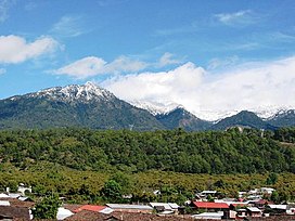
236:state. It is the highest peak in Michoacán.
670:
668:
666:
804:Flora and fauna protection areas of Mexico
271:Plant communities on the mountain include
29:
426:. Creepers and lianas include species of
141:
662:
746:
744:
742:
513:. Herbs and shrubs include species of
7:
824:Michoacán–Guanajuato volcanic field
257:Michoacán–Guanajuato volcanic field
682:from the original on 28 April 2024
610:Eleutherodactylus angustidigitorum
25:
140:
133:
38:
809:Important Bird Areas of Mexico
107:19.416505000°N 102.319723000°W
1:
767:10.5154/r.rchsza.2012.06.026.
630:Popocatepetl alligator lizard
314:less common. Oaks, including
57:3,840 m (12,600 ft)
819:Protected areas of Michoacán
224:, is a volcanic mountain in
112:19.416505000; -102.319723000
67:1,663 m (5,456 ft)
799:Trans-Mexican Volcanic Belt
210:Trans-Mexican Volcanic Belt
840:
127:
37:
244:Pico de Tancítaro is an
638:Baird's patchnose snake
602:Ambystoma amblycephalum
598:blunt-headed salamander
789:Landforms of Michoacán
784:Volcanoes of Michoacán
614:Montezuma leopard frog
606:Pátzcuaro peeping frog
594:Myadestes occidentalis
590:Brown-backed solitaire
345:Eupatorium mairetianum
618:Lithobates montezumae
490:Muhlenbergia macroura
470:Aegopogon cenchroides
794:Mountains of Mexico
486:Festuca breviglumis
464:Juniperus monticola
377:Carpinus tropicalis
341:Berberis moranensis
285:Pinus pseudostrobus
228:. It is located in
103: /
733:2024-04-28 at the
710:2020-11-09 at the
586:Accipiter cooperii
510:Zeugités americana
504:Trisetum virlettii
482:Festuca amplissima
474:Bouteloua purpurea
387:Crataegus mexicana
373:Quercus calophylla
337:Arbutus glandulosa
47:Highest point
644:), among others.
634:Barisia imbricata
390:, and species of
317:Quercus crassipes
305:Pinus douglasiana
277:alpine grasslands
218:Pico de Tancítaro
215:
214:
148:Pico de Tancítaro
33:Pico de Tancítaro
27:Volcano in Mexico
16:(Redirected from
831:
768:
764:
758:
748:
737:
725:
714:
698:
692:
691:
689:
687:
672:
642:Salvadora bairdi
478:Bromus exaltatus
351:Lippia umbellata
289:Pinus montezumae
232:municipality in
222:Volcán Tancítaro
220:, also known as
144:
143:
137:
118:
117:
115:
114:
113:
108:
104:
101:
100:
99:
98:102°19′11.0028″W
96:
42:
30:
21:
18:Volcán Tancítaro
839:
838:
834:
833:
832:
830:
829:
828:
774:
773:
772:
771:
765:
761:
749:
740:
735:Wayback Machine
726:
717:
712:Wayback Machine
702:Volcano Hotspot
699:
695:
685:
683:
674:
673:
664:
659:
650:
363:Pinus hartwegii
357:Abies religiosa
333:Alnus acuminata
321:Quercus laurina
311:Pinus maximinoi
293:Pinus devoniana
273:pine-oak forest
269:
242:
159:
158:
157:
156:
155:
152:
151:
150:
149:
145:
111:
109:
105:
102:
97:
95:19°24′59.4180″N
94:
92:
90:
89:
78:Pico de Orizaba
28:
23:
22:
15:
12:
11:
5:
837:
835:
827:
826:
821:
816:
811:
806:
801:
796:
791:
786:
776:
775:
770:
769:
759:
738:
715:
693:
661:
660:
658:
655:
649:
646:
429:Archibaccharis
327:Quercus rugosa
268:
265:
241:
238:
213:
212:
207:
196:
195:
190:
184:
183:
179:
178:
165:
161:
160:
153:
147:
146:
139:
138:
132:
131:
130:
129:
128:
125:
124:
120:
119:
87:
81:
80:
75:
69:
68:
65:
59:
58:
55:
49:
48:
44:
43:
35:
34:
26:
24:
14:
13:
10:
9:
6:
4:
3:
2:
836:
825:
822:
820:
817:
815:
812:
810:
807:
805:
802:
800:
797:
795:
792:
790:
787:
785:
782:
781:
779:
763:
760:
757:
756:968-5762-01-5
753:
747:
745:
743:
739:
736:
732:
729:
724:
722:
720:
716:
713:
709:
706:
703:
697:
694:
681:
677:
671:
669:
667:
663:
656:
654:
647:
645:
643:
639:
635:
631:
627:
623:
619:
615:
611:
607:
603:
599:
595:
591:
587:
583:
582:Cooper's hawk
578:
576:
575:
570:
569:
565:
561:
557:
553:
549:
545:
541:
537:
533:
529:
525:
521:
517:
512:
511:
506:
505:
500:
499:
498:Piptochaetium
495:
491:
487:
483:
479:
475:
471:
466:
465:
459:
457:
453:
449:
448:
443:
442:
438:
434:
430:
425:
424:
419:
418:
414:
410:
406:
402:
398:
394:
389:
388:
384:
379:
378:
374:
367:
365:
364:
359:
358:
353:
352:
347:
346:
342:
338:
334:
329:
328:
323:
322:
318:
313:
312:
307:
306:
301:
300:
299:Pinus teocote
295:
294:
290:
286:
280:
278:
274:
266:
264:
262:
258:
254:
253:stratovolcano
251:
247:
239:
237:
235:
231:
227:
223:
219:
211:
208:
206:
202:
197:
194:
193:Stratovolcano
191:
189:
188:Mountain type
185:
180:
177:
173:
169:
166:
162:
136:
126:
121:
116:
88:
86:
82:
79:
76:
74:
70:
66:
64:
60:
56:
54:
50:
45:
41:
36:
31:
19:
762:
701:
696:
684:. Retrieved
651:
641:
633:
625:
617:
609:
601:
593:
585:
579:
572:
514:
508:
502:
468:
462:
460:
456:Crassulaceae
445:
437:Philadelphus
427:
421:
391:
383:Alnus arguta
381:
371:
368:
361:
355:
349:
331:
325:
315:
309:
303:
297:
283:
281:
270:
243:
221:
217:
216:
686:14 December
626:Kinosternon
622:mud turtles
110: /
85:Coordinates
73:Parent peak
778:Categories
657:References
564:Ranunculus
560:Potentilla
540:Gnaphalium
452:Piperaceae
405:Cinnamomum
63:Prominence
544:Juniperus
524:Cerastium
494:Poa annua
433:Celastrus
397:Symplocos
261:Parícutin
246:andesitic
234:Michoacán
230:Tancítaro
199:Volcanic
172:Michoacán
168:Tancítaro
123:Geography
53:Elevation
731:Archived
708:Archived
680:Archived
574:Trisetum
556:Plantago
552:Phacelia
536:Eryngium
516:Arenaria
417:Viburnum
393:Meliosma
164:Location
636:), and
568:Senecio
528:Cirsium
423:Xylosma
302:, with
267:Ecology
250:dacitic
240:Geology
182:Geology
754:
628:sp.),
571:, and
548:Luzula
507:, and
444:, and
441:Smilax
420:, and
409:Styrax
401:Prunus
348:, and
324:, and
296:, and
226:Mexico
176:Mexico
154:Mexico
532:Draba
520:Carex
501:sp.,
447:Vitis
413:Tilia
752:ISBN
688:2020
454:and
308:and
205:belt
620:),
612:),
604:),
596:),
588:),
201:arc
780::
741:^
718:^
678:.
665:^
577:.
566:,
562:,
558:,
554:,
550:,
546:,
542:,
538:,
534:,
530:,
526:,
522:,
518:,
496:,
492:,
488:,
484:,
480:,
476:,
472:,
458:.
439:,
435:,
431:,
415:,
411:,
407:,
403:,
399:,
395:,
385:,
380:,
375:,
343:,
339:,
335:,
319:,
291:,
287:,
174:,
170:,
690:.
640:(
632:(
624:(
616:(
608:(
600:(
592:(
584:(
248:-
203:/
20:)
Text is available under the Creative Commons Attribution-ShareAlike License. Additional terms may apply.