364:
29:
225:, and two new public parks. In April 1999, Gateway Regional Visitor Center which highlighted the region's nature and technology was opened. In Spring 2000, the 140-boat slip Volunteer Landing Marina, was completed. The Regas Riverfront Tavern/Restaurant, which seated about 250 people and had a banquet facility with capacity of 300, was also completed in 2000, concluding the waterfront development project.
248:
379:. In 2017, a privately owned boat hit the dock and damaged it. It was closed afterwards, though the city had already planned improvements prior to the incident. The replacement dock cost $ 270,000 and 75 percent was financed by a TWRA grant. In April 2018, city-owned 360-foot-long boat dock reopened.
208:
was created to analyze the waterfront area along the
Tennessee River. Per the recommendations of this task force, a three-phase project to develop Volunteer Landing began in 1995 and continued through 1996. Volunteer Landing was completed in September 1997. Upon this completion, Volunteer Landing had
382:
The Vol Navy dock is near
Neyland Stadium. The dock and concrete pavilion were built 1994 and was funded by a TWRA grant. In 1998, 200 feet were added. In 2019, the new dock was completed. It is nearly 600 feet long. The TWRA funded the project with a $ 400,000 grant and $ 100,000 came from the city
265:
Volunteer
Landing has 13 acres (5.3 ha). Two new public parks were built as part of Volunteer Landing. One is called River Mountain Park, and it is west of the central pavilion and demonstrates the region's river and mountain heritage through the landscaping and water features. The second park
232:(TWRA) grant. The visitor center was received $ 5.6 million in federal, state, and local funds. The tavern/restaurant had about $ 6 million of private funding. The overall cost was $ 42 million and consisted of both
715:
668:
557:
228:
The state and local government contributed $ 10 million to
Volunteer Landing. The marina was funded with about $ 3 million in private funds and a $ 100,000
725:
76:
363:
698:
156:
451:
418:
596:
558:
Knoxville/Knox County, Tennessee
Empowerment Zone, Empowerment Zones / Enterprise Communities, Annual Report, July 1, 2009 – July 2, 2010
229:
269:
Volunteer
Landing Park is a three-acre linear park connects James White Greenway and Neyland Greenway. They are part of the downtown
233:
332:
69:
720:
324:
143:
383:
and UT. The Public
Building Authority managed the project. The city owns the dock and UT maintains it.
376:
270:
257:
182:
58:
266:
is at the mouth of First Creek where the city was founded and has exhibits reflecting this history.
628:
282:
447:
414:
408:
328:
202:
198:
186:
441:
372:
252:
178:
336:
709:
352:
28:
480:
290:
515:
344:
340:
294:
286:
222:
205:
174:
170:
47:
43:
91:
78:
210:
62:
443:
Five-Star Trails: Knoxville: Your Guide to the Area's Most
Beautiful Hikes
239:
In 2007, the Public
Building Authority began to manage Volunteer Landing.
320:
214:
556:
Knoxville/Knox County, Tennessee
Empowerment Zone (September 20, 2010).
247:
413:. Moon Blue Ridge and Smoky Mountains. Avalon Publishing. p. 276.
316:
312:
308:
304:
348:
298:
362:
246:
218:
669:"New Vol Navy dock opens in time for first Tennessee home game"
591:
589:
587:
585:
583:
581:
579:
577:
367:
Dock near the restaurant Calhoun's On The River, November 2019
475:
473:
471:
469:
623:
621:
619:
617:
446:. Five-Star Trails. Menasha Ridge Press. p. 33.
273:
system which is 19 miles long and runs east to west.
150:
139:
131:
123:
115:
107:
68:
53:
39:
21:
335:lines the river at Volunteer Landing as part of a
510:
508:
506:
504:
502:
500:
16:Riverwalk and public park in Knoxville, Tennessee
663:
661:
659:
657:
655:
653:
651:
649:
597:"City-owned dock at Volunteer Landing reopens"
8:
197:The location of the park is the site of the
716:Tourist attractions in Knoxville, Tennessee
18:
551:
549:
547:
545:
543:
541:
539:
537:
535:
392:
402:
400:
398:
396:
323:are some available activities. During
410:Moon Blue Ridge & Smoky Mountains
261:parked underneath the roadway bridges
7:
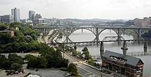
135:Dawn to dusk unless posted otherwise
38:
281:The one-mile walk features several
230:Tennessee Wildlife Resources Agency
127:Knoxville Public Building Authority
516:"Knoxville Waterfront Development"
14:
726:1997 establishments in Tennessee
52:
27:
251:View of Volunteer Landing from
234:public and private developments
122:
1:
375:was originally built for the
485:World's Fair Park Knoxville
339:tradition. There is also a
742:
35:
26:
601:Knoxville News Sentinel
325:University of Tennessee
201:. In 1988, a 50-member
92:35.958733°N 83.916817°W
368:
262:
366:
250:
140:Public transit access
97:35.958733; -83.916817
258:Three Rivers Rambler
183:Knoxville, Tennessee
629:"Volunteer Landing"
481:"Volunteer Landing"
440:Molloy, J. (2011).
88: /
57:300 Neyland Drive,
721:Parks in Tennessee
633:Visit Knoxville TN
369:
263:
185:. It is below the
453:978-0-89732-922-4
420:978-1-59880-532-1
407:Huso, D. (2010).
377:1982 World's Fair
291:riverboat cruises
223:pedestrian bridge
199:Treaty of Holston
187:Gay Street Bridge
167:Volunteer Landing
164:
163:
119:City of Knoxville
22:Volunteer Landing
733:
702:
701:
699:Official website
684:
683:
681:
680:
665:
644:
643:
641:
640:
625:
612:
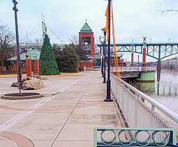
611:
609:
608:
593:
572:
571:
569:
568:
562:
553:
530:
529:
527:
526:
512:
495:
494:
492:
491:
477:
464:
463:
461:
460:
437:
431:
430:
428:
427:
404:
160:
159:
157:Official website
124:Operated by
103:
102:
100:
99:
98:
93:
89:
86:
85:
84:
81:
31:
19:
741:
740:
736:
735:
734:
732:
731:
730:
706:
705:
697:
696:
693:
688:
687:
678:
676:
667:
666:
647:
638:
636:
627:
626:
615:
606:
604:
595:
594:
575:
566:
564:
560:
555:
554:
533:
524:
522:
520:About Knoxville
514:
513:
498:
489:
487:
479:
478:
467:
458:
456:
454:
439:
438:
434:
425:
423:
421:
406:
405:
394:
389:
361:
279:
253:Neyland Stadium
245:
195:
179:Tennessee River
155:
154:
96:
94:
90:
87:
82:
79:
77:
75:
74:
17:
12:
11:
5:
739:
737:
729:
728:
723:
718:
708:
707:
704:
703:
692:
691:External links
689:
686:
685:
645:
613:
573:
531:
496:
465:
452:
432:
419:
391:
390:
388:
385:
360:
357:
278:
275:
244:
241:
194:
191:
162:
161:
152:
148:
147:
141:
137:
136:
133:
129:
128:
125:
121:
120:
117:
113:
112:
109:
105:
104:
72:
66:
65:
55:
51:
50:
41:
37:
36:
33:
32:
24:
23:
15:
13:
10:
9:
6:
4:
3:
2:
738:
727:
724:
722:
719:
717:
714:
713:
711:
700:
695:
694:
690:
674:
670:
664:
662:
660:
658:
656:
654:
652:
650:
646:
634:
630:
624:
622:
620:
618:
614:
602:
598:
592:
590:
588:
586:
584:
582:
580:
578:
574:
559:
552:
550:
548:
546:
544:
542:
540:
538:
536:
532:
521:
517:
511:
509:
507:
505:
503:
501:
497:
486:
482:
476:
474:
472:
470:
466:
455:
449:
445:
444:
436:
433:
422:
416:
412:
411:
403:
401:
399:
397:
393:
386:
384:
380:
378:
374:
365:
358:
356:
354:
350:
347:, a shelter,
346:
342:
338:
334:
330:
326:
322:
318:
314:
310:
306:
302:
300:
296:
292:
288:
284:
276:
274:
272:
267:
260:
259:
254:
249:
242:
240:
237:
235:
231:
226:
224:
220:
216:
212:
207:
204:
200:
192:
190:
188:
184:
180:
176:
172:
168:
158:
153:
149:
145:
142:
138:
134:
130:
126:
118:
116:Owned by
114:
110:
106:
101:
73:
71:
67:
64:
60:
56:
49:
45:
42:
34:
30:
25:
20:
677:. Retrieved
675:. 2019-08-30
672:
637:. Retrieved
635:. 2014-08-30
632:
605:. Retrieved
603:. 2018-04-20
600:
565:. Retrieved
523:. Retrieved
519:
488:. Retrieved
484:
457:. Retrieved
442:
435:
424:. Retrieved
409:
381:
370:
303:
280:
268:
264:
256:
255:showing the
238:
227:
213:, a central
196:
166:
165:
355:available.
351:areas, and
345:splash pads
331:games, the
295:restaurants
287:train rides
283:attractions
243:Description
171:public park
95: /
70:Coordinates
44:Public park
710:Categories
679:2020-07-30
639:2020-07-29
607:2020-07-30
567:2020-07-31
525:2020-07-29
490:2020-07-29
459:2020-07-24
426:2020-07-24
387:References
341:playground
337:tailgating
327:(UT) home
277:Activities
206:task force
203:waterfront
177:along the
146:10, 11, 17
83:83°55′01″W
80:35°57′31″N
353:restrooms
211:boardwalk
175:riverwalk
63:Tennessee
59:Knoxville
48:riverwalk
673:wbir.com
563:(Report)
333:Vol Navy
329:football
321:paddling
297:, and a
285:such as
271:greenway
215:pavilion
54:Location
317:running
313:walking
305:Fishing
193:History
151:Website
108:Created
450:
417:
349:picnic
319:, and
309:biking
299:marina
561:(PDF)
359:Docks
219:plaza
169:is a
448:ISBN
415:ISBN
373:dock
371:One
221:, a
217:and
173:and
132:Open
111:1997
40:Type
181:in
144:KAT
712::
671:.
648:^
631:.
616:^
599:.
576:^
534:^
518:.
499:^
483:.
468:^
395:^
343:,
311:,
307:,
301:.
293:,
289:,
236:.
209:a
189:.
61:,
46:,
682:.
642:.
610:.
570:.
528:.
493:.
462:.
429:.
315:/
Text is available under the Creative Commons Attribution-ShareAlike License. Additional terms may apply.