433:
100:
50:
75:
174:
452:
155:
33:
791:
460:
820:
107:
82:
57:
428:
The main course of the Wadi
Rahabah flows from east to west, receiving in its path the contribution of several ravines and tributary wadis, to the left and right, of which the most relevant, due to its flow and length, is the Wadi Zireb, tributary on the right, whose mouth occurs very shortly before
498:
In addition to some modern farms, the remains of two old villages are preserved along the course of the Wadi
Rahabah: one next to the mouth of the Wadi Zireb, the left tributary of the Wadi Rahabah, and a second village located almost at the foot of the great cliffs which forms the
398:; to the south with the Wadi Bakhit basin; and to the west with the inlet and coastal wetland of Khawr Hulaylah, into which it flows, located in the Persian Gulf, next to the town of Seih Al Qurum (Qurm), northwest of the town of Kabdah, and north of the city of Ar Rams.
662:
Tribulus - Volume 19 - 2011 - Journal of the
Emirates Natural History Group - The Flora of the Ru'us al-Jibal -the Mountains of the Musandam Peninsula: An Annotated Checklist and Selected Observations - Gary R. Feulner - Abu Dhabi, United Arab Emirates,
586:
Map of
Trucial States, Muscat and Oman - Rams - Scale 1:100 000 - Published by D Survey, Ministry of Defence, United Kingdom (1971) - Edition 3-GSGS - The National Archives, London, England <
378:, with an approximate area of 12.42 km (4.80 sq mi), to the north, it limits with the drainage basins of wadis and smaller ravines that pour their waters directly into the
844:
570:
Jāmiʻat al-Imārāt al-ʻArabīyah al-Muttaḥidah. Geoprojects (U.K.) Ltd., The
National atlas of the United Arab Emirates, Al Ain : United Arab Emirates University - 1993
99:
49:
475:
The name of this wadi appears mentioned in documents and maps prepared between 1950 and 1960 by the
British Arabist, cartographer, military officer and diplomat
532:
410:
514:, and corresponded to the tribal area of Mahabib, which in recent years has been practically devastated by intensive open pit mining, from the neighboring
527:
839:
74:
735:
Julian Fortay Walker (1958) - Sketch map drawn by Julian Walker for boundary delimitation: Ras Al
Khaimah - The National Archives, London, England
242:
757:
Land and sea boundaries of
Trucial Sheikhdoms in Persian Gulf - Ref. FO 371/114648 PAGE 147- The National Archives, London, England <
602:"A discussion of rock carvings in Ra's al Khaimah Emirate, UAE, and Musandam province, Sultanate of Oman, using local considerations"
432:
744:
Boundary between East Aden
Protectorate and Muscat and Oman - Ref. FCO 8/586 PAGE 50- The National Archives, London, England <
700:
649:
FCO 8/586 - 1967-1968 Boundary between East Aden
Protectorate and Muscat and Oman - The National Archives, London, England <
429:
the dam built in 2021 (Rahba Dam), intended to feed underground water resources and reduce damage due to eventual floods.
363:
or river with intermittent flow, which flows almost exclusively during the rainy season, located in the northeast of the
230:
Inlet and coastal wetland of Khawr Hulaylah, located in the Persian Gulf, next to the town of Seih Al Qurum (Qurm)
542:
368:
204:
179:
472:
Alternative names: Wadi Rahabah, Wadi Rahbah, Wadi Al Rahba, Wādī Raḩabah, Wādī Raḩbah, Wadi Ruhaba, Wadi Rahba
448:), located a short distance from the bed, which receives the attention of numerous tourists and other visitors.
824:
413:, almost at the foot of the Rahabah South Col (1,470 m (4,820 ft)), on the Jabal ar Rahrah Ridge.
601:
479:, and in many other documents related to the work carried out to establish borders between the then called
483:, later completed by the United Kingdom´s Ministry of Defense, on 1:100,000 scale maps published in 1971.
451:
349:
401:
The source of the main channel of the Wadi Rahabah is located approximately 1,350 m (4,430 ft)
537:
420:, are the ruins of an old village, with numerous dry stone constructions, and there is a small spring.
364:
160:
506:
The entire area near the Wadi Rahabah and its tributaries was mainly populated by the semi-nomadic
32:
795:
790:
500:
459:
417:
406:
200:
621:
613:
476:
758:
340:
135:
808:
notmidtbø - You pretty thing 6b+. With extra challenge at the top. Wadi Rahbah, UAE, 2023
480:
375:
306:
745:
664:
650:
833:
617:
486:
In the National Atlas of the United Arab Emirates it is identified with the spelling
387:
587:
511:
379:
416:
A short distance from the wall of the great cliff that forms the western slope of
463:
Wadi Rahabah / Wadi Rahbah. Ruins of an old town, in the upper course of the wadi
794:
Upper course of Wadi Rahabah / Wadi Rahbah. Large cliff on the western slope of
436:
Stardust Climbing Crag. Rock climbing area in the middle reaches of Wadi Rahabah
383:
225:
807:
360:
770:
687:
676:
638:
625:
257:
244:
395:
819:
402:
391:
811:
440:
In the middle course of the wadi there is an area of cliffs, known as
723:
507:
789:
677:
Mindat.org - Khawr Ḩulaylah, Ra’s al Khaymah, United Arab Emirates
458:
450:
431:
726:
27crags.com - Stardust - Ra's al Khaymah, United Arab Emirates
639:
Mindat.org - Wādī Raḩbah, Ra’s al Khaymah, United Arab Emirates
701:"UAE approves $ 44 million projects in water infrastructure |"
781:
444:, frequently used for rock climbing and a picturesque cave (
771:
Mindat.org - Maḩābīb, Ra’s al Khaymah, United Arab Emirates
690:
Mindat.org - Qurm, Ra’s al Khaymah, United Arab Emirates]
759:
https://www.agda.ae/en/catalogue/tna/fo/371/114648/n/147
455:
Wadi Rahabah Cave. Cave in the middle course of the wadi
354:
746:
https://www.agda.ae/en/catalogue/tna/fco/8/586/n/50
665:
https://enhg.org/Portals/1/trib/V19/TribulusV19.pdf
651:
https://www.agda.ae/en/catalogue/tna/fco/8/586/n/50
518:quarry, property of the Emirate of Ras al Khaimah.
324:
316:
304:
299:
291:
283:
273:
234:
224:
210:
195:
186:
166:
148:
143:
123:
21:
600:Lancaster, William; Lancaster, Fidelity (2011).
588:https://www.agda.ae/en/catalogue/tna/fco/18/1785
533:List of mountains in the United Arab Emirates
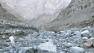
37:View of the middle course of the Wadi Rahabah
8:
127:
409:(1,543 m (5,062 ft)), one of the
845:Geography of the Emirate of Ras Al Khaimah
688:https://www.mindat.org/feature-291129.html
582:
580:
578:
576:
528:List of wadis of the United Arab Emirates
566:
564:
562:
560:
558:
554:
390:; to the east and southeast, with the
18:
7:
295:12.42 km (4.80 sq mi)
106:
81:
56:
344:
128:
724:https://27crags.com/crags/stardust
14:
606:Arabian Archaeology and Epigraphy
503:in the upper course of the wadi.
114:Show map of West and Central Asia
818:
618:10.1111/j.1600-0471.2011.00338.x
411:highest mountains in the country
172:
153:
105:
98:
80:
73:
64:Show map of United Arab Emirates
55:
48:
31:
840:Valleys of United Arab Emirates
394:sub-basin, a tributary of the
382:and with the sub-basin of the
236: • coordinates
1:
705:meconstructionnews.com - 2020
187:Physical characteristics
275: • elevation
216:1,350 m (4,430 ft)
212: • elevation
355:
861:
543:List of mountains in Oman
369:Emirate of Ras Al Khaimah
220:
205:Emirate of Ras Al Khaimah
191:
42:
30:
405:on the western slope of
326: • right
89:Show map of Persian Gulf
396:Wadi Shah / Wadi Shehah
287:7 km (4.3 mi)
258:25.925556°N 56.050556°E
798:
464:
456:
442:Stardust Climbing Crag
437:
827:at Wikimedia Commons
793:
538:List of wadis of Oman
462:
454:
435:
386:, a tributary of the
365:United Arab Emirates
279:0 m (0 ft)
263:25.925556; 56.050556
161:United Arab Emirates
300:Basin features
254: /
799:
510:tribe, section of
465:
457:
438:
823:Media related to
782:www.stevinrock.ae
446:Wadi Rahabah Cave
374:It forms its own
353:
334:
333:
199:Western slope of
852:
822:
784:
779:
773:
768:
762:
755:
749:
742:
736:
733:
727:
721:
715:
714:
712:
711:
697:
691:
685:
679:
674:
668:
660:
654:
647:
641:
636:
630:
629:
597:
591:
584:
571:
568:
477:Julian F. Walker
358:
348:
346:
327:
309:
269:
268:
266:
265:
264:
259:
255:
252:
251:
250:
247:
213:
182:
178:
176:
175:
159:
157:
156:
139:
131:
130:
115:
109:
108:
102:
90:
84:
83:
77:
65:
59:
58:
52:
35:
19:
860:
859:
855:
854:
853:
851:
850:
849:
830:
829:
804:
788:
787:
780:
776:
769:
765:
756:
752:
743:
739:
734:
730:
722:
718:
709:
707:
699:
698:
694:
686:
682:
675:
671:
661:
657:
648:
644:
637:
633:
599:
598:
594:
585:
574:
569:
556:
551:
524:
496:
470:
426:
325:
305:
276:
262:
260:
256:
253:
248:
245:
243:
241:
240:
237:
211:
173:
171:
170:
154:
152:
133:
119:
118:
117:
116:
113:
112:
111:
110:
93:
92:
91:
88:
87:
86:
85:
68:
67:
66:
63:
62:
61:
60:
38:
26:
23:
17:
16:Wadi in the UAE
12:
11:
5:
858:
856:
848:
847:
842:
832:
831:
816:
815:
803:
802:External links
800:
786:
785:
774:
763:
750:
737:
728:
716:
692:
680:
669:
655:
642:
631:
612:(2): 166–195.
592:
572:
553:
552:
550:
547:
546:
545:
540:
535:
530:
523:
520:
495:
492:
481:Trucial States
469:
466:
425:
422:
376:drainage basin
332:
331:
328:
322:
321:
318:
314:
313:
310:
302:
301:
297:
296:
293:
289:
288:
285:
281:
280:
277:
274:
271:
270:
238:
235:
232:
231:
228:
222:
221:
218:
217:
214:
208:
207:
197:
193:
192:
189:
188:
184:
183:
180:Ras Al Khaimah
168:
164:
163:
150:
146:
145:
141:
140:
125:
121:
120:
104:
103:
97:
96:
95:
94:
79:
78:
72:
71:
70:
69:
54:
53:
47:
46:
45:
44:
43:
40:
39:
36:
28:
27:
24:
15:
13:
10:
9:
6:
4:
3:
2:
857:
846:
843:
841:
838:
837:
835:
828:
826:
821:
813:
809:
806:
805:
801:
797:
796:Jabal Rahabah
792:
783:
778:
775:
772:
767:
764:
760:
754:
751:
747:
741:
738:
732:
729:
725:
720:
717:
706:
702:
696:
693:
689:
684:
681:
678:
673:
670:
666:
659:
656:
652:
646:
643:
640:
635:
632:
627:
623:
619:
615:
611:
607:
603:
596:
593:
589:
583:
581:
579:
577:
573:
567:
565:
563:
561:
559:
555:
548:
544:
541:
539:
536:
534:
531:
529:
526:
525:
521:
519:
517:
513:
509:
504:
502:
501:Jabal Rahabah
493:
491:
489:
484:
482:
478:
473:
467:
461:
453:
449:
447:
443:
434:
430:
423:
421:
419:
418:Jabal Rahabah
414:
412:
408:
407:Jabal Rahabah
404:
399:
397:
393:
389:
388:Wadi Ghalilah
385:
381:
377:
372:
370:
366:
362:
357:
351:
342:
338:
329:
323:
319:
315:
311:
308:
303:
298:
294:
290:
286:
282:
278:
272:
267:
239:
233:
229:
227:
223:
219:
215:
209:
206:
202:
201:Jabal Rahabah
198:
194:
190:
185:
181:
169:
165:
162:
151:
147:
142:
137:
126:
122:
101:
76:
51:
41:
34:
29:
20:
825:Wadi Rahabah
817:
777:
766:
753:
740:
731:
719:
708:. Retrieved
704:
695:
683:
672:
658:
645:
634:
609:
605:
595:
515:
512:Bani Shatair
505:
497:
487:
485:
474:
471:
445:
441:
439:
427:
415:
400:
380:Persian Gulf
373:
337:Wadi Rahabah
336:
335:
312:Wadi Rahabah
307:River system
249:56°03′02.0″E
246:25°55′32.0″N
22:Wadi Rahabah
516:Stevin Rock
488:Wādī Raḩbah
384:Wadi Halhal
356:Wādī Raḩbah
317:Tributaries
261: /
124:Native name
25:Wādī Raḩbah
834:Categories
710:2024-04-11
549:References
494:Population
361:dry valley
330:Wadi Zireb
292:Basin size
626:1600-0471
367:, in the
350:romanized
345:وادي رحبة
203:, in the
129:وادي رحبة
663:2011<
522:See also
468:Toponymy
403:altitude
392:Wadi Jib
359:), is a
144:Location
812:YouTube
352::
167:Emirate
149:Country
624:
508:Shihuh
424:Course
341:Arabic
320:
284:Length
196:Source
177:
158:
136:Arabic
132:
226:Mouth
761:>
748:>
667:>
653:>
622:ISSN
590:>
614:doi
836::
703:.
620:.
610:22
608:.
604:.
575:^
557:^
490:.
371:.
347:,
343::
814:)
810:(
713:.
628:.
616::
339:(
138:)
134:(
Text is available under the Creative Commons Attribution-ShareAlike License. Additional terms may apply.