41:
28:
48:
283:
sultan of Sanaa in 1184 (584 AH), was located below the summit, on the southern side of the mountain. At the top of the mountain was another fortification called al-ʽAnqā'. The fort of Fiddah remained in use until the downfall of the
212:
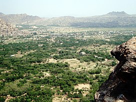
and then flows eastward for about 7km through a steep-sided gorge before ending on the Sanaa plain. Wadi Zahr has fertile soil and was historically a strategic area with several forts. The main settlement in the area today is
278:
Jabal Fiddah is a steep-sided mountain on the south side of the wadi. Al-Hamdani described it as "a high rocky peak which is very precipitous and (therefore) beyond the reach of climbers." The main fort, built by the
253:
Wadi Zahr is mentioned very frequently in historical sources from the medieval and early modern periods. Its significance came from both its strategic value and its agricultural production. It was a bastion of the
467:
121:
296:
West of Fiddah, and also on the southern side of Wadi Zahr, is the fort of Ṭaybah, which is now in ruins. It was originally called
310:
226:
40:
321:
350:), now in ruins, is located on the north side of Wadi Zahr. Its first mention is in the year 1386 (788 AH), also in the
114:
205:
462:
285:
335:
316:
305:
200:
on the western edge of the Sanaa plain. It is watered by a perennial stream whose source is the large
330:
209:
338:. It is then mentioned several more times in that text as a frequently contested stronghold.
280:
214:
176:
159:
100:
201:
270:
Wadi Zahr is the site of several historic forts, including Fiddah, Ṭaybah, and Munif:
27:
456:
237:." He says that the wadi is named after one Ḍahr ibn Saʽd ibn ʽArīb, of the tribe of
363:
255:
432:
387:
259:
234:
136:
123:
238:
197:
193:
233:, and specifically states that "it is said Wādī Ḍahr, spelt with
189:
437:. Germany: Georg Olms AG. pp. 165, 221, 224, 262, 265, 322
183:
166:
113:
108:
88:
83:
75:
67:
18:
79:7 km (4.3 mi) west to east
208:. The wadi proper begins near the village of
8:
92:
426:
424:
422:
420:
418:
416:
414:
412:
410:
408:
382:
380:
15:
324:. The first reference to the modern name
308:), and under this name it appears in the
434:Gazetteer of Historical North-West Yemen
376:
229:consistently spells the wadi's name as
328:is in the year 1324 (724 AH), in the
7:
180:
163:
93:
14:
47:
366:, a historic palace in Wadi Zahr
304:, the vocalization preferred by
46:
39:
26:
468:Geography of Sanaa Governorate
1:
431:Wilson, Robert T.O. (1989).
71:2,229 m (7,313 ft)
262:tribe, who ruled the area.
245:, however, is more common.
184:
167:
484:
204:on the eastern slopes of
34:
25:
225:The 10th-century writer
196:, located just north of
346:The fortress of Munif (
314:of al-Hamdani and the
288:in the 16th century.
286:Sharaf al-Din dynasty
206:Jabal An-Nabi Shu'ayb
137:15.45517°N 44.14734°E
336:Yahya ibn al-Husayn
133: /
142:15.45517; 44.14734
153:
152:
475:
447:
446:
444:
442:
428:
403:
402:
400:
398:
384:
306:Muhammad al-Akwa
187:
182:
171:), also spelled
170:
165:
148:
147:
145:
144:
143:
138:
134:
131:
130:
129:
126:
104:
96:
95:
50:
49:
43:
30:
16:
483:
482:
478:
477:
476:
474:
473:
472:
453:
452:
451:
450:
440:
438:
430:
429:
406:
396:
394:
388:"Geonames.org.
386:
385:
378:
373:
360:
352:Ghayat al-amani
344:
331:Ghayat al-amani
294:
276:
268:
251:
241:. The spelling
223:
215:Qaryat al-Qabil
141:
139:
135:
132:
127:
124:
122:
120:
119:
98:
68:Floor elevation
63:
62:
61:
60:
59:
58:
57:
51:
12:
11:
5:
481:
479:
471:
470:
465:
463:Wadis of Yemen
455:
454:
449:
448:
404:
375:
374:
372:
369:
368:
367:
359:
356:
343:
340:
293:
290:
275:
272:
267:
264:
250:
247:
222:
219:
210:Suq Bayt Naʽam
202:catchment area
151:
150:
117:
111:
110:
106:
105:
90:
86:
85:
81:
80:
77:
73:
72:
69:
65:
64:
53:
52:
45:
44:
38:
37:
36:
35:
32:
31:
23:
22:
13:
10:
9:
6:
4:
3:
2:
480:
469:
466:
464:
461:
460:
458:
436:
435:
427:
425:
423:
421:
419:
417:
415:
413:
411:
409:
405:
393:
391:
383:
381:
377:
370:
365:
362:
361:
357:
355:
353:
349:
341:
339:
337:
333:
332:
327:
323:
319:
318:
317:Tarikh Sanʽa'
313:
312:
307:
303:
299:
291:
289:
287:
282:
273:
271:
265:
263:
261:
257:
248:
246:
244:
240:
236:
232:
228:
220:
218:
216:
211:
207:
203:
199:
195:
191:
186:
178:
174:
169:
161:
157:
146:
118:
116:
112:
107:
102:
91:
87:
82:
78:
74:
70:
66:
56:
42:
33:
29:
24:
21:
17:
439:. Retrieved
433:
395:. Retrieved
389:
364:Dar al-Hajar
351:
347:
345:
329:
325:
315:
309:
301:
297:
295:
277:
269:
252:
242:
230:
224:
172:
155:
154:
54:
19:
441:10 February
397:10 February
260:Banu Hamdan
140: /
115:Coordinates
89:Native name
457:Categories
390:Wādī Z̧ahr
371:References
348:Ḥiṣn Munīf
227:al-Hamdani
128:44°08′50″E
125:15°27′19″N
256:Isma'ilis
231:Wādī Ḍahr
185:Wādī Ḍahr
173:Wadi Dahr
168:Wādī Ẓahr
156:Wadi Zahr
109:Geography
55:Wadi Zahr
20:Wadi Zahr
358:See also
188:), is a
181:وادي ضهر
164:وادي ظهر
94:وادي ظهر
322:al-Razi
258:of the
249:History
149:
326:Ṭaybah
298:Dawram
292:Ṭaybah
281:Hatimi
274:Fiddah
239:Himyar
177:Arabic
160:Arabic
101:Arabic
97:
84:Naming
76:Length
342:Munif
311:Iklil
302:Dūram
266:Forts
198:Sanaa
194:Yemen
443:2021
399:2021
300:(or
243:Ẓahr
221:Name
190:wadi
334:of
320:of
235:ḍād
192:in
459::
407:^
379:^
354:.
217:.
179::
162::
445:.
401:.
392:"
175:(
158:(
103:)
99:(
Text is available under the Creative Commons Attribution-ShareAlike License. Additional terms may apply.