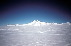
466:. A massive mountain rising to 3,239 metres (10,627 ft) high, forming the central and highest peak of Eternity Range. First seen from the air and named Mount Hope by Lincoln Ellsworth during his flights of November 21 and 23, 1935. The mountain was surveyed and given the name Mount Wakefield by J.R. Rymill of BGLE in November 1936. The feature was subsequently photographed from the air by the USAS in September 1940, and by RARE in December 1947. A careful study of the reports, maps, and photographs of these expeditions, as well as additional survey of the area by FIDS in 1960, has led to the conclusion that Ellsworth's Mount Hope and Rymill's Mount Wakefield are synonymous. For the sake of historical continuity the name Mount Hope has been retained for this mountain, and the name Wakefield has been transferred to Wakefield Highland located close northwestward.
504:. A massive mountain 9 nautical miles (17 km; 10 mi) south of Mount Hope, rising 2,680 metres (8,790 ft) high from the south end of Eternity Range. First seen from the air and named by Lincoln Ellsworth during his flights of November 21 and 23, 1935. Surveyed by J.R. Rymill of BGLE in November 1936. The mountain was subsequently photographed from the air by the US AS in September 1940, and by RARE in December 1947. The feature is one of three major mountains in Ellsworth's Eternity Range to which he gave the names Faith, Hope and Charity.
682:. A mountain, 2,070 metres (6,790 ft) high, standing 12 nautical miles (22 km; 14 mi) east of the north part of the Eternity Range. This feature lies in the area explored from the air by Sir Hubert Wilkins in 1928 and Lincoln Ellsworth in 1935, but it was first charted by the BGLE in 1936-37. It was photographed from the air in 1940 by the USAS and in 1947 by the RARE under Ronne. Named by Ronne for Colonel H.R. Sullivan of the Office of Research and Development of the then USAAF, which furnished equipment for the expedition.
250:
155:
148:
528:
540:
380:
40:
516:
422:. A massive mountain 9 nautical miles (17 km; 10 mi) north of Mount Hope, rising to 2,650 metres (8,690 ft) high from the north end of Eternity Range. First seen from the air and named by Lincoln Ellsworth during his flights of November 21 and 23, 1935. Surveyed by J.R. Rymill of BGLE in November 1936. The mountain was subsequently photographed from the air by the US AS in September 1940, and RARE in December 1947.
1090:
1040:
309:(BGLE) who gave the name "Mount Wakefield" to the central mountain in the range. This complication by Rymill, and uncertainty as to the precise location or extent of Ellsworth's discovery, hindered for a time a resolution of its nomenclature. Thus, following the
328:(FIDS), 1960, has led to the conclusion that the range described comprises at least the core of Ellsworth's Eternity Range and appropriately commemorates his discovery. The name "Wakefield", given by Rymill, has been transferred to nearby Wakefield Highland.
643:
in 1947, and recharted in 1947 by a joint sledge party consisting of members of the RARE and FIDS. Named by Ronne for R.F. Duemler, vice president of the
Delaware, Lackawanna and Western Coal Co., New York, which contributed coal to the expedition.
1094:
1044:
289:. Features, from north to south, are Mount Faith, Mount Hope and Mount Charity. Nearby features include Brand Peak, Mount Duemler and Mount Sullivan to the east, and Wakefield Highland and Davies Top to the north.
814:. Photographed from the air by RARE on December 22, 1947. Surveyed by FIDS in November 1960. Named by UK-APC after Anthony G. Davies of FIDS, Medical Officer at Horseshoe Island and Stonington Island, 1960.
585:. A sharp snow-covered peak located 10 nautical miles (19 km; 12 mi) east-southeast of the Eternity Range and 4 nautical miles (7.4 km; 4.6 mi) northwest of Mount Duemler. Mapped by the
300:
discovered the range from the air during his flights of
November 21 and November 23, 1935. He applied the names Eternity Range and Mounts Faith, Hope and Charity. In November 1936, the range was surveyed by
639:, inland from the east coast of Palmer Land. This feature was first chartered by the BGLE under Rymill in 1936-37. It was photographed from the air by the USAS in 1940, and the RARE under
237:) is a range of mountains 28 nautical miles (52 km; 32 mi) long, rising to 3,239 metres (10,627 ft), and trending north–south approximately in the middle of the
82:
850:(BAS) announced that satellite data had shown that Mount Hope was 3,239 metres (10,627 ft) high, the highest in the British Antarctic Territory, moving
200:
765:
1113:
1048:
147:
527:
590:
241:. The range is divided into three main mountain blocks, the major summits in each from north to south being Mounts Faith, Hope and Charity.
1055:
325:
321:
769:
320:
A careful study of the original reports, maps and photographs, and comparison with materials from subsequent expeditions such as the
539:
772:(UK-APC) and the US-ACAN, restores the name Wakefield in the vicinity of the BGLE's displaced "Mount Wakefield" (now Mount Hope).
1098:
586:
310:
286:
306:
810:. A conspicuous isolated peak 2,360 metres (7,740 ft) high on the east side of Wakefield Highland, near the head of
1118:
75:
58:
851:
313:(USAS) expedition in 1939–41, the name Eternity Range or Eternity Mountains was incorrectly applied to the present
782:
692:
654:
636:
603:
557:
476:
438:
394:
341:
847:
431:
846:
Albert (1995) gives the elevation of the highest point as 2,860 metres (9,380 ft). In
December 2017 the
249:
764:. Photographed from the air by RARE on December 22, 1947. Surveyed by FIDS in November 1960. Named after
515:
729:
368:
721:
363:
302:
238:
379:
358:
733:
297:
282:
39:
811:
761:
753:
749:
632:
314:
278:
1071:
757:
745:
725:
266:
1107:
274:
1022:
855:
823:
741:
737:
270:
17:
631:. Mountain, 2,225 metres (7,300 ft) high, rising southwest of the head of
262:
258:
185:
858:
is still the highest mountain in
Antarctica, at 4,892 metres (16,050 ft).
640:
353:
797:
784:
707:
694:
669:
656:
618:
605:
572:
559:
491:
478:
453:
440:
409:
396:
216:
202:
98:
84:
593:(US-ACAN) for Timothy Brand, USARP biologist at Palmer Station in 1974.
1057:
New satellite imagery reveals new highest
Antarctic Peninsula Mountain
768:, a contributor to BGLE, 1934-37. This toponym, concurred in by the
65:
378:
248:
880:
878:
876:
874:
253:
Mount Hope south face - oblique view from east in March 2004
317:
60 nautical miles (110 km; 69 mi) farther south.
383:
Northern Palmer Land. Eternity Range upper center of map
854:
at 3,184 metres (10,446 ft) down to second place.
635:
and 11 nautical miles (20 km; 13 mi) west of
1030:(2 ed.), United States Board on Geographic Names
896:
181:
173:
135:
127:
122:
74:
64:
54:
49:
32:
1060:, BAS; British Antarctic Survey, 11 December 2017
8:
908:
589:(USGS) in 1974. Named by the United States
533:Southern Mount Duemler, view towards south
29:
27:Mountain range in Palmer Land, Antarctica
842:
840:
1076:, USGS: United States Geological Survey
1049:United States Board on Geographic Names
1004:
992:
980:
968:
956:
944:
932:
920:
884:
870:
836:
511:
720:. A snow-covered highland in central
269:to the west. It is to the east of the
154:
591:Advisory Committee on Antarctic Names
7:
826:, the Antarctic Peninsula Cordillera
326:Falkland Islands Dependencies Survey
322:Ronne Antarctic Research Expedition
1097:from websites or documents of the
1047:from websites or documents of the
770:UK Antarctic Place-Names Committee
257:The Eternity Range is in northern
25:
1024:Geographic Names of the Antarctic
752:and to the east by the heads of
1093: This article incorporates
1088:
1043: This article incorporates
1038:
538:
526:
514:
153:
146:
38:
1099:United States Geological Survey
587:United States Geological Survey
545:Eastern ridge of Mount Sullivan
311:United States Antarctic Service
1114:Mountain ranges of Palmer Land
1021:Alberts, Fred G., ed. (1995),
736:, to the west by the heads of
307:British Graham Land Expedition
1:
70:3,239 m (10,627 ft)
44:Mount Charity, view from east
766:Viscount Wakefield of Hythe
369:GPX (secondary coordinates)
1135:
724:, bounded to the north by
429:
897:New satellite imagery BAS
364:GPX (primary coordinates)
339:Map all coordinates using
140:
37:
848:British Antarctic Survey
432:Mount Hope (Palmer Land)
347:Download coordinates as:
277:, south of the head of
131:28 mi (45 km)
1095:public domain material
1045:public domain material
384:
324:(RARE), 1947, and the
254:
382:
359:GPX (all coordinates)
252:
730:Weyerhaeuser Glacier
1119:Antarctic Peninsula
887:, pp. 226–227.
794: /
722:Antarctic Peninsula
704: /
666: /
615: /
569: /
488: /
450: /
406: /
303:John Riddoch Rymill
273:, southeast of the
239:Antarctic Peninsula
212: /
94: /
748:, to the south by
686:Wakefield Highland
385:
293:Discovery and name
287:Columbia Mountains
255:
50:Highest point
18:Wakefield Highland
798:69.400°S 64.933°W
734:Aphrodite Glacier
728:and the heads of
708:69.333°S 65.167°W
670:69.650°S 63.817°W
619:70.017°S 63.750°W
573:70.017°S 63.917°W
492:69.900°S 64.567°W
454:69.767°S 64.567°W
410:69.617°S 64.483°W
298:Lincoln Ellsworth
285:and north of the
217:69.767°S 64.567°W
191:
190:
99:69.767°S 64.567°W
16:(Redirected from
1126:
1092:
1091:
1083:
1082:
1081:
1067:
1066:
1065:
1042:
1041:
1037:
1036:
1035:
1029:
1008:
1002:
996:
990:
984:
978:
972:
966:
960:
954:
948:
942:
936:
930:
924:
918:
912:
909:Palmer Land USGS
906:
900:
894:
888:
882:
859:
844:
809:
808:
806:
805:
804:
803:-69.400; -64.933
799:
795:
792:
791:
790:
787:
719:
718:
716:
715:
714:
713:-69.333; -65.167
709:
705:
702:
701:
700:
697:
681:
680:
678:
677:
676:
675:-69.650; -63.817
671:
667:
664:
663:
662:
659:
630:
629:
627:
626:
625:
624:-70.017; -63.750
620:
616:
613:
612:
611:
608:
584:
583:
581:
580:
579:
578:-70.017; -63.917
574:
570:
567:
566:
565:
562:
542:
530:
518:
503:
502:
500:
499:
498:
497:-69.900; -64.567
493:
489:
486:
485:
484:
481:
465:
464:
462:
461:
460:
459:-69.767; -64.567
455:
451:
448:
447:
446:
443:
421:
420:
418:
417:
416:
415:-69.617; -64.483
411:
407:
404:
403:
402:
399:
283:Stefansson Sound
265:to the east and
236:
235:
233:
232:
231:
229:
224:
223:
222:-69.767; -64.567
218:
213:
210:
209:
208:
205:
157:
156:
150:
118:
117:
115:
114:
113:
111:
106:
105:
104:-69.767; -64.567
100:
95:
92:
91:
90:
87:
42:
30:
21:
1134:
1133:
1129:
1128:
1127:
1125:
1124:
1123:
1104:
1103:
1089:
1086:
1079:
1077:
1070:
1063:
1061:
1054:
1039:
1033:
1031:
1027:
1020:
1016:
1011:
1003:
999:
991:
987:
979:
975:
967:
963:
955:
951:
943:
939:
931:
927:
919:
915:
907:
903:
895:
891:
883:
872:
868:
863:
862:
845:
838:
833:
820:
812:Lurabee Glacier
802:
800:
796:
793:
788:
785:
783:
781:
780:
778:
762:Grimley Glacier
754:Lurabee Glacier
750:Fleming Glacier
712:
710:
706:
703:
698:
695:
693:
691:
690:
688:
674:
672:
668:
665:
660:
657:
655:
653:
652:
650:
633:Anthony Glacier
623:
621:
617:
614:
609:
606:
604:
602:
601:
599:
577:
575:
571:
568:
563:
560:
558:
556:
555:
553:
546:
543:
534:
531:
522:
519:
510:
508:Nearby features
496:
494:
490:
487:
482:
479:
477:
475:
474:
472:
458:
456:
452:
449:
444:
441:
439:
437:
436:
434:
428:
414:
412:
408:
405:
400:
397:
395:
393:
392:
390:
377:
376:
375:
374:
373:
334:
315:Welch Mountains
295:
279:Lurabee Glacier
247:
227:
225:
221:
219:
215:
214:
211:
206:
203:
201:
199:
198:
169:
168:
167:
166:
165:
164:
163:
162:
158:
109:
107:
103:
101:
97:
96:
93:
88:
85:
83:
81:
80:
45:
28:
23:
22:
15:
12:
11:
5:
1132:
1130:
1122:
1121:
1116:
1106:
1105:
1085:
1084:
1068:
1052:
1017:
1015:
1012:
1010:
1009:
1007:, p. 175.
997:
995:, p. 791.
985:
983:, p. 722.
973:
971:, p. 202.
961:
949:
947:, p. 129.
937:
935:, p. 344.
925:
923:, p. 231.
913:
901:
889:
869:
867:
864:
861:
860:
835:
834:
832:
829:
828:
827:
819:
816:
777:
774:
758:Sunfix Glacier
746:Seller Glacier
726:Hermes Glacier
687:
684:
649:
648:Mount Sullivan
646:
598:
595:
552:
549:
548:
547:
544:
537:
535:
532:
525:
523:
520:
513:
509:
506:
471:
468:
430:Main article:
427:
424:
389:
386:
372:
371:
366:
361:
356:
350:
344:
337:
336:
335:
333:
330:
294:
291:
267:Marguerite Bay
261:, between the
246:
243:
228:Eternity Range
195:Eternity Range
189:
188:
183:
179:
178:
175:
171:
170:
161:Eternity Range
160:
159:
152:
151:
145:
144:
143:
142:
141:
138:
137:
133:
132:
129:
125:
124:
120:
119:
110:Eternity Range
78:
72:
71:
68:
62:
61:
56:
52:
51:
47:
46:
43:
35:
34:
33:Eternity Range
26:
24:
14:
13:
10:
9:
6:
4:
3:
2:
1131:
1120:
1117:
1115:
1112:
1111:
1109:
1102:
1100:
1096:
1075:
1074:
1069:
1059:
1058:
1053:
1050:
1046:
1026:
1025:
1019:
1018:
1013:
1006:
1001:
998:
994:
989:
986:
982:
977:
974:
970:
965:
962:
959:, p. 89.
958:
953:
950:
946:
941:
938:
934:
929:
926:
922:
917:
914:
910:
905:
902:
898:
893:
890:
886:
881:
879:
877:
875:
871:
865:
857:
853:
852:Mount Jackson
849:
843:
841:
837:
830:
825:
822:
821:
817:
815:
813:
807:
775:
773:
771:
767:
763:
759:
755:
751:
747:
743:
739:
735:
731:
727:
723:
717:
685:
683:
679:
647:
645:
642:
638:
634:
628:
597:Mount Duemler
596:
594:
592:
588:
582:
550:
541:
536:
529:
524:
517:
512:
507:
505:
501:
470:Mount Charity
469:
467:
463:
433:
425:
423:
419:
387:
381:
370:
367:
365:
362:
360:
357:
355:
352:
351:
349:
348:
343:
342:OpenStreetMap
340:
331:
329:
327:
323:
318:
316:
312:
308:
304:
299:
292:
290:
288:
284:
280:
276:
275:Bristly Peaks
272:
268:
264:
260:
251:
244:
242:
240:
234:
196:
187:
184:
180:
176:
172:
149:
139:
134:
130:
126:
121:
116:
79:
77:
73:
69:
67:
63:
60:
57:
53:
48:
41:
36:
31:
19:
1087:
1078:, retrieved
1072:
1062:, retrieved
1056:
1032:, retrieved
1023:
1005:Alberts 1995
1000:
993:Alberts 1995
988:
981:Alberts 1995
976:
969:Alberts 1995
964:
957:Alberts 1995
952:
945:Alberts 1995
940:
933:Alberts 1995
928:
921:Alberts 1995
916:
904:
892:
885:Alberts 1995
856:Mount Vinson
824:Antarctandes
779:
742:Rotz Glacier
738:Airy Glacier
689:
651:
637:Mount Bailey
600:
554:
473:
435:
391:
346:
345:
338:
319:
296:
271:Dyer Plateau
256:
194:
192:
1073:Palmer Land
801: /
711: /
673: /
622: /
576: /
495: /
457: /
413: /
388:Mount Faith
263:Weddell Sea
259:Palmer Land
220: /
186:Palmer Land
102: /
76:Coordinates
1108:Categories
1080:2024-04-25
1064:2024-04-29
1034:2023-12-03
866:References
776:Davies Top
641:Finn Ronne
551:Brand Peak
521:Brand Peak
426:Mount Hope
281:, west of
226: (
177:Antarctica
123:Dimensions
108: (
59:Mount Hope
174:Continent
136:Geography
66:Elevation
818:See also
332:Features
245:Location
1014:Sources
789:64°56′W
786:69°24′S
699:65°10′W
696:69°20′S
661:63°49′W
658:69°39′S
610:63°45′W
607:70°01′S
564:63°55′W
561:70°01′S
483:64°34′W
480:69°54′S
445:64°34′W
442:69°46′S
401:64°29′W
398:69°37′S
305:of the
207:64°34′W
204:69°46′S
89:64°34′W
86:69°46′S
182:Region
128:Length
1028:(PDF)
831:Notes
760:and
744:and
732:and
193:The
55:Peak
354:KML
1110::
1101:.
873:^
839:^
756:,
740:,
1051:.
911:.
899:.
230:)
197:(
112:)
20:)
Text is available under the Creative Commons Attribution-ShareAlike License. Additional terms may apply.