242:
282:
230:
266:
40:
254:
788:
301:
241:
306:
281:
162:
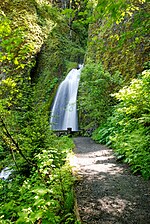
in that the water does not directly plunge to the ground. Wahkeena Falls, rather, has a more subtle cascading flow. These falls have been featured in numerous travel guides and in photography books.
69:
833:
877:
867:
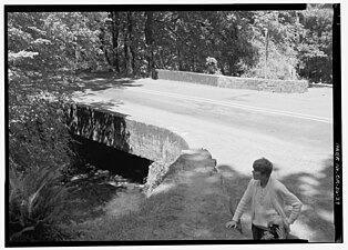
184:. A 0.2-mile (320 m) hike from the parking lot at the base leads to the stone bridge that crosses the main part of the falls. That trail continues on east to
437:
229:
265:
862:
826:
738:
697:
208:
872:
819:
649:
212:
430:
405:
272:
204:
189:
177:
857:
852:
423:
62:
253:
474:
165:
Spellings of this name are dubious because the word is an
English transliteration of a Native American (reportedly
795:
504:
199:, an 18-foot-long (5.5 m) bridge having "a simple reinforced-concrete slab span", below the falls, is a
614:
534:
519:
200:
619:
377:
489:
452:
144:
748:
654:
639:
588:
374:"National Historic Landmark Nomination: Columbia River Highway / Historic Columbia River Highway"
390:
763:
743:
659:
634:
629:
514:
348:
181:
39:
803:
373:
702:
676:
609:
556:
551:
410:
Historic
Columbia River Highway, Wahkeena Falls Footbridge, Troutdale, Multnomah County, OR
671:
593:
509:
494:
469:
185:
159:
846:
753:
707:
561:
546:
499:
17:
758:
733:
712:
664:
524:
479:
717:
681:
644:
624:
302:
List of bridges documented by the
Historic American Engineering Record in Oregon
148:
84:
71:
787:
140:
101:
188:, the next falls to the east. This waterfall is visible directly from the
409:
332:
415:
799:
307:
List of bridges on the
National Register of Historic Places in Oregon
166:
152:
419:
807:
726:
690:
602:
581:
574:
533:
460:
451:
126:
118:
110:
100:
61:
53:
32:
334:A Waterfall Lover's Guide to the Pacific Northwest
287:Showing path to viewing area & bridge, 2009.
337:(4th ed.), Seattle: The Mountaineers Books
827:
431:
8:
834:
820:
578:
457:
438:
424:
416:
412:", 1 photo, 1 photo caption page
38:
29:
878:Multnomah County, Oregon geography stubs
326:
324:
322:
318:
225:
868:Waterfalls of Multnomah County, Oregon
372:Hadlow, Robert W. (February 4, 2000).
211:in 1983, and was further designated a
180:, about 13 miles (21 km) east of
7:
784:
782:
406:Historic American Engineering Record
209:National Register of Historic Places
213:National Historic Landmark District
806:. You can help Knowledge (XXG) by
25:
786:
280:
264:
252:
240:
228:
863:Historic Columbia River Highway
273:Historic Columbia River Highway
205:Historic Columbia River Highway
190:Historic Columbia River Highway
178:Historic Columbia River Highway
158:The waterfall is unlike nearby
125:
117:
109:
1:
271:Wahkeena Falls Bridge on the
802:state location article is a
176:Wahkeena Falls is along the
353:Portland Hikers Field Guide
894:
873:Mount Hood National Forest
781:
408:(HAER) No. OR-36-F, "
331:Plumb, Gregory A. (2005),
259:Wahkeena Falls Footbridge.
207:, which was listed on the
139:is a 242-foot (74 m)
49:
37:
27:Waterfall in Oregon, U.S.
615:Silver Falls State Park
57:Multnomah Falls, Oregon
391:accompanying 33 photos
201:contributing structure
378:National Park Service
349:"Wahkeena Falls Hike"
197:Wahkeena Creek Bridge
114:560 feet (170 m)
18:Wahkeena Creek Bridge
858:Columbia River Gorge
853:Waterfalls of Oregon
446:Waterfalls of Oregon
145:Columbia River Gorge
122:242 feet (74 m)
85:45.5745°N 122.1276°W
81: /
90:45.5745; -122.1276
815:
814:
776:
775:
772:
771:
691:Southern Cascades
603:Willamette Valley
570:
569:
182:Troutdale, Oregon
169:) phrase meaning
134:
133:
16:(Redirected from
885:
836:
829:
822:
796:Multnomah County
790:
783:
582:Northwest Oregon
579:
539:(north to south)
520:Hole-in-the-Wall
458:
440:
433:
426:
417:
393:
388:
386:
384:
369:
363:
362:
360:
359:
345:
339:
338:
328:
284:
268:
256:
244:
232:
96:
95:
93:
92:
91:
86:
82:
79:
78:
77:
74:
42:
30:
21:
893:
892:
888:
887:
886:
884:
883:
882:
843:
842:
841:
840:
779:
777:
768:
722:
686:
598:
566:
537:
529:
447:
444:
402:
397:
396:
382:
380:
371:
370:
366:
357:
355:
347:
346:
342:
330:
329:
320:
315:
298:
293:
292:
291:
288:
285:
276:
269:
260:
257:
248:
245:
236:
233:
221:
186:Multnomah Falls
160:Multnomah Falls
127:Number of drops
89:
87:
83:
80:
75:
72:
70:
68:
67:
45:
28:
23:
22:
15:
12:
11:
5:
891:
889:
881:
880:
875:
870:
865:
860:
855:
845:
844:
839:
838:
831:
824:
816:
813:
812:
791:
774:
773:
770:
769:
767:
766:
761:
756:
751:
746:
741:
736:
730:
728:
727:Central Oregon
724:
723:
721:
720:
715:
710:
705:
700:
694:
692:
688:
687:
685:
684:
679:
674:
669:
668:
667:
662:
657:
652:
647:
642:
637:
632:
627:
622:
612:
606:
604:
600:
599:
597:
596:
591:
585:
583:
576:
572:
571:
568:
567:
565:
564:
559:
554:
549:
543:
541:
531:
530:
528:
527:
522:
517:
512:
507:
502:
497:
492:
487:
482:
477:
472:
466:
464:
462:(west to east)
455:
453:Columbia Gorge
449:
448:
445:
443:
442:
435:
428:
420:
414:
413:
401:
400:External links
398:
395:
394:
364:
340:
317:
316:
314:
311:
310:
309:
304:
297:
294:
290:
289:
286:
279:
277:
270:
263:
261:
258:
251:
249:
246:
239:
237:
234:
227:
224:
223:
222:
220:
217:
171:most beautiful
137:Wahkeena Falls
132:
131:
128:
124:
123:
120:
116:
115:
112:
108:
107:
104:
98:
97:
65:
59:
58:
55:
51:
50:
47:
46:
44:Wahkeena Falls
43:
35:
34:
33:Wahkeena Falls
26:
24:
14:
13:
10:
9:
6:
4:
3:
2:
890:
879:
876:
874:
871:
869:
866:
864:
861:
859:
856:
854:
851:
850:
848:
837:
832:
830:
825:
823:
818:
817:
811:
809:
805:
801:
797:
792:
789:
785:
780:
765:
762:
760:
757:
755:
752:
750:
749:Paulina Creek
747:
745:
742:
740:
737:
735:
732:
731:
729:
725:
719:
716:
714:
711:
709:
706:
704:
701:
699:
696:
695:
693:
689:
683:
680:
678:
675:
673:
670:
666:
663:
661:
658:
656:
653:
651:
648:
646:
643:
641:
638:
636:
633:
631:
628:
626:
623:
621:
618:
617:
616:
613:
611:
608:
607:
605:
601:
595:
592:
590:
587:
586:
584:
580:
577:
573:
563:
560:
558:
555:
553:
550:
548:
545:
544:
542:
540:
536:
532:
526:
523:
521:
518:
516:
513:
511:
508:
506:
503:
501:
500:Oneonta Gorge
498:
496:
493:
491:
488:
486:
483:
481:
478:
476:
473:
471:
468:
467:
465:
463:
459:
456:
454:
450:
441:
436:
434:
429:
427:
422:
421:
418:
411:
407:
404:
403:
399:
392:
379:
375:
368:
365:
354:
350:
344:
341:
336:
335:
327:
325:
323:
319:
312:
308:
305:
303:
300:
299:
295:
283:
278:
274:
267:
262:
255:
250:
243:
238:
235:October 2012.
231:
226:
218:
216:
214:
210:
206:
202:
198:
193:
191:
187:
183:
179:
174:
172:
168:
163:
161:
156:
154:
150:
146:
142:
138:
129:
121:
113:
105:
103:
99:
94:
66:
64:
60:
56:
52:
48:
41:
36:
31:
19:
808:expanding it
793:
778:
640:Middle North
589:Youngs River
538:
484:
461:
381:. Retrieved
367:
356:. Retrieved
352:
343:
333:
196:
194:
175:
170:
164:
157:
136:
135:
119:Total height
764:Upper Chush
744:Lava Island
660:Upper North
635:Lower South
630:Lower North
575:Other areas
535:Eagle Creek
515:Camp Benson
475:Bridal Veil
383:January 12,
88: /
76:122°07′39″W
63:Coordinates
847:Categories
703:Mill Creek
677:Salt Creek
610:Willamette
552:Punch Bowl
358:2013-02-28
313:References
73:45°34′28″N
672:Shellburg
594:Ki-a-Kuts
510:Wahclella
505:Horsetail
495:Multnomah
470:Latourell
247:May 2017.
215:in 2000.
141:waterfall
111:Elevation
485:Wahkeena
296:See also
54:Location
754:Pringle
708:Toketee
562:Twister
557:Wy'east
547:Metlako
219:Gallery
203:in the
147:in the
143:in the
800:Oregon
759:Tumalo
739:Dillon
734:Benham
713:Watson
698:Dillon
665:Winter
620:Double
525:Celilo
480:Coopey
167:Yakama
153:Oregon
106:Tiered
794:This
718:Yakso
682:Proxy
650:South
645:North
625:Drake
490:Fairy
389:With
149:state
804:stub
655:Twin
385:2022
195:The
102:Type
151:of
849::
798:,
376:.
351:.
321:^
192:.
173:.
155:.
835:e
828:t
821:v
810:.
439:e
432:t
425:v
387:.
361:.
275:.
130:6
20:)
Text is available under the Creative Commons Attribution-ShareAlike License. Additional terms may apply.