38:
62:
408:, flowing south to the Wairoa Reservoir, and once exiting the Hunua Ranges changing course to flow northwards. Paparimu Road and Hunua Road follow the course of the river as it flows northwards through farmland. Much of the western Hunua Ranges flows into the Wairoa River, including Cosseys Creek and the Ōtau Valley, both of which have been dammed as freshwater reservoirs. In addition to these, the Wairoa River is joined by other tributaries: the Mangawheau Stream, the Hunua Stream which flows past the settlement of
90:
97:
1638:
69:
1621:
394:
505:). The river mouth formed the traditional heartland of Ngāi Tai ki Tāmaki. Ngāi Tai peoples traditionally lived in seasonal cycles, focusing on fishing and shellfish collecting, cultivations and collecting berries and snaring birds in the river's upper reaches, depending on the season. The river-mouth was used as a summer pioke (
532:, who then planted these at Te Hūnua, along the Wairoa River (likely near modern-day Clevedon). These were the first crop of potatoes grown in New Zealand, and three years later, potatoes were gifted during a feast at Te Hūnua to the tribes of the Hauraki Gulf and Waikato, becoming some of the first varieties of rīwai (
583:, Ōtau was attacked by the British army, and the village was evacuated. After which, the residents moved to live in communities at the river's mouth. For the remainder of the war, Ngāi Tai were designated as a "friendly" people by the Crown, and remained neutral in the fighting. After the Native Lands Act of 1865, the
603:
began developing a management strategy for the river, with was further developed in 2016 with the founding of the Wairoa River
Steering Group, now a part of the volunteer conversation group Friends of Te Wairoa Catchment, which formed in 2017. In 2017, the Wairoa River won a New Zealand River Award
579:. Ngāi Tai held a defended settlement on the eastern banks of the Wairoa River opposite Clevedon, known as Ōtau. During the first decade post European settlement, Ngāi Tai and the European settlers had cordial relations, trading goods and assisting each other. In September 1863 during the
591:
In the early 1900s, the river mouth became popular with
Auckland residents for duck shooting and picnicking. In 1955, the Cosseys Creek Dam was constructed in the Hunua Ranges, a rolled earth dam constructed to secure fresh water supplies for
563:
in 1841 and 1842 and found to be excessive and reduced in size. The disallowed parts of his purchase were not returned to Ngāi Tai, however in 1854 a reserve was created for Ngāi Tai between the eastern shores of the Wairoa River and
587:
individuated the collective Ngāi Tai lands, and in the process the majority of land near the Wairoa River was alienated and sold to
European farmers. During European settlement, most of the Wairoa River catchment was deforested.
1136:
1287:
492:
hapū of the Wairoa river valley between the 14th and 16th centuries included Te
Ngungukauri, Te Uri Kupai, Ngāti Ruangaingai and Ngāti Parahanga, who identified as both Ngāti Tai Manawaiti, and Ngā Iwi
1280:
1104:
1252:
1273:
1030:
61:
1037:
945:
484:. Te Wairoa was a name applying to the river mouth and surrounding area, while Ōtau referred to the upstream areas further, including where the river passes by
1688:
225:
170:
1064:
89:
1093:
624:
are popular tourist destinations, accessible by the Hunua Falls Path. The lower Wairoa River north of
Clevedon is navigable by boats and canoes.
37:
1668:
1198:
1609:
929:
1663:
1683:
1678:
1673:
994:
596:. This was joined by the Wairoa Ram in 1975. The construction of the dams significantly reduced the flow of the Wairoa River.
1627:
633:
1518:
1265:
708:
1297:
560:
621:
1562:
1523:
1498:
600:
444:
era, approximately 3 to 4 million years ago. Originally it was a westwards-flowing river, flowing into the proto-
736:
1590:
1503:
575:
From 1854, European farming settlers began to arrive on the banks of the Wairoa River, forming the township of
22:
502:
469:
1579:
1329:
740:
712:
580:
540:
1493:
416:. Past Clevedon, the river veers north-east, meeting the Urungahauhau Stream and the Aroaro Stream of the
132:
1528:
1509:
1384:
1374:
1344:
576:
485:
449:
413:
382:
287:
1549:
1324:
1132:
1092:
Ngāi Tai Ki Tāmaki and the
Trustees of the Ngāi Tai Ki Tāmaki Trust and the Crown (7 November 2015).
559:), including much of the catchment of the Wairoa River. Fairburn's Purchase was investigated by the
1483:
1447:
1432:
1334:
584:
1349:
1256:
506:
429:
417:
489:
1437:
1415:
1177:
925:
533:
1544:
1452:
1202:
1143:
1071:
1001:
952:
269:
211:
1584:
1176:(Report). Water & Soil Division, Ministry of Works and Development. pp. 113–114.
605:
445:
358:
137:
1170:
509:
shark) fishing ground, which were dried for the winter months. Ngāi Tai settled at many
1478:
1442:
1420:
1379:
1369:
529:
473:
452:. Much of the river flows along the Wairoa River Gorge, formed along a fault line. The
378:
1224:
501:
Te Wana in the early 18th century, under the name Ngāti Tai (now more widely known as
468:
The Wairoa River's traditional name, Te Wairoa ("The Great River") was named by early
1657:
1554:
1457:
917:
457:
277:
552:
1488:
1427:
1410:
1405:
1400:
1359:
569:
556:
525:
521:
425:
405:
381:
form sections of the river, and the Wairoa River flows adjacent to the township of
374:
370:
366:
273:
156:
1305:
1031:
109 Beachlands Road, Beachlands, Auckland: Preliminary
Archaeological Assessment
995:Ōtau: a Ngāi Tai Cultural Heritage Assessment of Clevedon Village, Wairoa Valley
617:
544:
453:
398:
362:
333:
206:
125:
1181:
891:
865:
839:
813:
787:
761:
679:
653:
240:
227:
185:
172:
543:
visited the area in 1833, it was mostly unoccupied due to the events of the
498:
477:
514:
1364:
1354:
1301:
593:
565:
441:
409:
1644:
393:
1339:
1319:
548:
494:
421:
481:
547:, as most members of Ngāi Tai had fled to temporary refuge in the
528:
area. Cook gifted potatoes to senior members of Te Uri ō Pou from
510:
392:
1171:
New
Zealand Recreational River Survey Part II North Island Rivers
412:, and the Taitaia Stream, which meets the Wairoa River north of
1269:
946:
The
Proposed Auckland Unitary Plan: Appendix 3 Natural heritage
480:, which in turn took its name from a similarly named river in
1603:
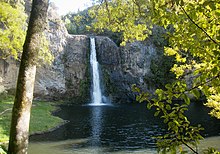
456:, a 30 metre high waterfall, flows overtop of an ancient
1058:
1056:
1054:
1063:
Heritage
Department of the Auckland Regional Council.
1199:"Action stations for Auckland's most improved river"
1029:
Clough, Tom; Apfel, Aaron; Clough, Rod (June 2020).
988:
986:
984:
982:
980:
978:
976:
974:
972:
970:
1572:
1537:
1471:
1393:
1312:
551:. In 1836, Fairburn purchased 40,000 acres between
339:
329:
321:
311:
301:
293:
283:
261:
256:
217:
205:
162:
152:
143:
131:
121:
116:
30:
1127:
1125:
924:. Geoscience Society of New Zealand. p. 225.
517:along the river, especially at the river's mouth.
1164:
1162:
1160:
1024:
1022:
1020:
1018:
307:Mangawheau Stream, Hunua Stream, Taitaia Stream
96:
68:
1281:
8:
731:
729:
620:and upper Wairoa River area located in the
1288:
1274:
1266:
497:). The related hapū were united under the
703:
701:
604:for being the most improved river in the
369:. It flows south from its sources in the
1193:
1191:
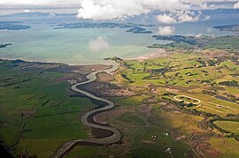
42:An aerial view of the Wairoa River mouth
1616:
645:
21:For the Kaipara Harbour tributary, see
27:
1110:from the original on 13 February 2020
1094:Deed of settlement schedule documents
357:, is the second longest river in the
104:Wairoa River (Auckland) (New Zealand)
7:
1563:Franklin District Council (defunct)
1169:Egarr, G. D.; Egarr, J. H. (1981).
1065:"Duder Regional Park - Our History"
1038:Environmental Protection Authority
440:The river first formed during the
397:The Wairoa River plunges over the
317:Cosseys Creek, Urungahauhau Stream
14:
1689:Wairoa River (Auckland) catchment
1636:
1619:
1223:Berthier, Jenn (20 April 2024).
404:The river begins in the central
95:
88:
67:
60:
36:
922:Out of the Ocean, Into the Fire
476:waka, referencing Te Vairoa in
898:. Land Information New Zealand
872:. Land Information New Zealand
846:. Land Information New Zealand
820:. Land Information New Zealand
794:. Land Information New Zealand
768:. Land Information New Zealand
686:. Land Information New Zealand
660:. Land Information New Zealand
219: • coordinates
164: • coordinates
16:River in Auckland, New Zealand
1:
1669:Rivers of the Auckland Region
634:List of rivers of New Zealand
144:Physical characteristics
1137:Wairoa Catchment Action Plan
1253:Photographs of Wairoa River
561:New Zealand Land Commission
377:. The Wairoa Reservoir and
373:, then northwards into the
1705:
1489:Hunua Ranges Regional Park
1472:Facilities and attractions
622:Hunua Ranges Regional Park
424:. The estuary reaches the
20:
1664:Franklin Local Board Area
1524:Tawhitokino Regional Park
1519:Tāpapakanga Regional Park
1499:Orere Point Regional Park
1298:Franklin Local Board Area
601:Auckland Regional Council
201:
148:
76:Mouth of the Wairoa River
54:
49:Route of the Wairoa River
47:
35:
1684:Estuaries of New Zealand
1591:Maraetai Mission Station
313: • right
241:36.938916°S 175.090313°E
23:Wairoa River (Northland)
1606:Wairoa River (Auckland)
1580:Beachlands Maraetai AFC
741:Engineering New Zealand
713:Engineering New Zealand
581:Invasion of the Waikato
541:William Thomas Fairburn
303: • left
107:Show map of New Zealand
1674:Hauraki Gulf catchment
401:
246:-36.938916; 175.090313
186:37.04425°S 175.14773°E
1608:at Knowledge (XXG)'s
1529:Waitawa Regional Park
1510:Drury railway station
1296:Wairoa Subdivision -
1259:heritage collections.
896:New Zealand Gazetteer
870:New Zealand Gazetteer
844:New Zealand Gazetteer
840:"Urungahauhau Stream"
818:New Zealand Gazetteer
792:New Zealand Gazetteer
766:New Zealand Gazetteer
684:New Zealand Gazetteer
658:New Zealand Gazetteer
520:In November of 1769,
396:
343:Clevedon Wharf Bridge
1550:Franklin Local Board
1133:Franklin Local Board
191:-37.04425; 175.14773
79:Show map of Auckland
1494:Ōmana Regional Park
1484:Duder Regional Park
1433:Mangemangeroa Creek
1394:Geographic features
1257:Auckland Libraries'
993:Green, Nat (2010).
955:. 30 September 2013
762:"Mangawheau Stream"
709:"Cosseys Creek Dam"
257:Basin features
237: /
182: /
1679:Ngāi Tai ki Tāmaki
1225:"Hunua Falls Path"
536:) in New Zealand.
507:Shortspine spurdog
503:Ngāi Tai ki Tāmaki
470:Ngāi Tai ki Tāmaki
402:
1601:
1600:
1438:Motukaraka Island
1416:Cosseys Reservoir
1229:Discover Auckland
931:978-0-473-39596-4
918:Hayward, Bruce W.
585:Native Land Court
472:ancestors of the
347:
346:
1696:
1649:
1641:
1640:
1639:
1632:
1624:
1623:
1622:
1612:
1545:Auckland Council
1448:Pōhutukawa Coast
1313:Populated places
1290:
1283:
1276:
1267:
1240:
1239:
1237:
1235:
1220:
1214:
1213:
1211:
1209:
1203:Auckland Council
1195:
1186:
1185:
1175:
1166:
1155:
1154:
1152:
1150:
1144:Auckland Council
1141:
1129:
1120:
1119:
1117:
1115:
1109:
1098:
1089:
1083:
1082:
1080:
1078:
1072:Auckland Council
1069:
1060:
1049:
1048:
1046:
1044:
1035:
1026:
1013:
1012:
1010:
1008:
1002:Auckland Council
999:
990:
965:
964:
962:
960:
953:Auckland Council
950:
942:
936:
935:
914:
908:
907:
905:
903:
888:
882:
881:
879:
877:
862:
856:
855:
853:
851:
836:
830:
829:
827:
825:
814:"Taitaia Stream"
810:
804:
803:
801:
799:
784:
778:
777:
775:
773:
758:
752:
751:
749:
747:
733:
724:
723:
721:
719:
705:
696:
695:
693:
691:
676:
670:
669:
667:
665:
650:
353:, also known as
325:Wairoa Reservoir
314:
304:
252:
251:
249:
248:
247:
242:
238:
235:
234:
233:
230:
197:
196:
194:
193:
192:
187:
183:
180:
179:
178:
175:
165:
108:
99:
98:
92:
80:
71:
70:
64:
40:
28:
1704:
1703:
1699:
1698:
1697:
1695:
1694:
1693:
1654:
1653:
1652:
1642:
1637:
1635:
1625:
1620:
1618:
1615:
1611:sister projects
1610:
1602:
1597:
1585:Franklin United
1568:
1533:
1467:
1389:
1308:
1294:
1263:
1249:
1244:
1243:
1233:
1231:
1222:
1221:
1217:
1207:
1205:
1197:
1196:
1189:
1173:
1168:
1167:
1158:
1148:
1146:
1139:
1131:
1130:
1123:
1113:
1111:
1107:
1096:
1091:
1090:
1086:
1076:
1074:
1067:
1062:
1061:
1052:
1042:
1040:
1033:
1028:
1027:
1016:
1006:
1004:
997:
992:
991:
968:
958:
956:
948:
944:
943:
939:
932:
916:
915:
911:
901:
899:
890:
889:
885:
875:
873:
866:"Aroaro Stream"
864:
863:
859:
849:
847:
838:
837:
833:
823:
821:
812:
811:
807:
797:
795:
786:
785:
781:
771:
769:
760:
759:
755:
745:
743:
735:
734:
727:
717:
715:
707:
706:
699:
689:
687:
680:"Cosseys Creek"
678:
677:
673:
663:
661:
652:
651:
647:
642:
630:
614:
606:Auckland Region
466:
446:Manukau Harbour
438:
420:and forming an
391:
359:Auckland Region
312:
302:
245:
243:
239:
236:
231:
228:
226:
224:
223:
220:
190:
188:
184:
181:
176:
173:
171:
169:
168:
163:
138:Auckland Region
112:
111:
110:
109:
106:
105:
102:
101:
100:
83:
82:
81:
78:
77:
74:
73:
72:
50:
43:
26:
17:
12:
11:
5:
1702:
1700:
1692:
1691:
1686:
1681:
1676:
1671:
1666:
1656:
1655:
1651:
1650:
1633:
1604:
1599:
1598:
1596:
1595:
1587:
1582:
1576:
1574:
1570:
1569:
1567:
1566:
1559:
1558:
1557:
1552:
1541:
1539:
1535:
1534:
1532:
1531:
1526:
1521:
1516:
1515:
1514:
1501:
1496:
1491:
1486:
1481:
1479:Ayrlies Garden
1475:
1473:
1469:
1468:
1466:
1465:
1460:
1455:
1450:
1445:
1440:
1435:
1430:
1425:
1424:
1423:
1418:
1408:
1403:
1397:
1395:
1391:
1390:
1388:
1387:
1382:
1380:Tuscany Estate
1377:
1372:
1367:
1362:
1357:
1352:
1347:
1342:
1337:
1332:
1327:
1322:
1316:
1314:
1310:
1309:
1295:
1293:
1292:
1285:
1278:
1270:
1261:
1260:
1248:
1247:External links
1245:
1242:
1241:
1215:
1187:
1156:
1121:
1084:
1050:
1014:
966:
937:
930:
909:
883:
857:
831:
805:
788:"Hunua Stream"
779:
753:
725:
697:
671:
654:"Wairoa River"
644:
643:
641:
638:
637:
636:
629:
626:
613:
610:
534:Māori potatoes
465:
462:
437:
434:
390:
387:
345:
344:
341:
337:
336:
331:
327:
326:
323:
319:
318:
315:
309:
308:
305:
299:
298:
295:
291:
290:
285:
281:
280:
263:
259:
258:
254:
253:
221:
218:
215:
214:
209:
203:
202:
199:
198:
166:
160:
159:
154:
150:
149:
146:
145:
141:
140:
135:
129:
128:
123:
119:
118:
114:
113:
103:
94:
93:
87:
86:
85:
84:
75:
66:
65:
59:
58:
57:
56:
55:
52:
51:
48:
45:
44:
41:
33:
32:
15:
13:
10:
9:
6:
4:
3:
2:
1701:
1690:
1687:
1685:
1682:
1680:
1677:
1675:
1672:
1670:
1667:
1665:
1662:
1661:
1659:
1648:from Wikidata
1647:
1646:
1634:
1630:
1629:
1617:
1613:
1607:
1594:
1592:
1588:
1586:
1583:
1581:
1578:
1577:
1575:
1573:Organisations
1571:
1565:
1564:
1560:
1556:
1555:Franklin ward
1553:
1551:
1548:
1547:
1546:
1543:
1542:
1540:
1536:
1530:
1527:
1525:
1522:
1520:
1517:
1513:
1511:
1507:
1506:
1505:
1504:Southern Line
1502:
1500:
1497:
1495:
1492:
1490:
1487:
1485:
1482:
1480:
1477:
1476:
1474:
1470:
1464:
1461:
1459:
1458:Umupuia Beach
1456:
1454:
1453:Tūranga Creek
1451:
1449:
1446:
1444:
1441:
1439:
1436:
1434:
1431:
1429:
1426:
1422:
1419:
1417:
1414:
1413:
1412:
1409:
1407:
1404:
1402:
1399:
1398:
1396:
1392:
1386:
1383:
1381:
1378:
1376:
1373:
1371:
1368:
1366:
1363:
1361:
1358:
1356:
1353:
1351:
1348:
1346:
1343:
1341:
1338:
1336:
1333:
1331:
1328:
1326:
1323:
1321:
1318:
1317:
1315:
1311:
1307:
1303:
1299:
1291:
1286:
1284:
1279:
1277:
1272:
1271:
1268:
1264:
1258:
1254:
1251:
1250:
1246:
1230:
1226:
1219:
1216:
1204:
1200:
1194:
1192:
1188:
1183:
1179:
1172:
1165:
1163:
1161:
1157:
1145:
1138:
1134:
1128:
1126:
1122:
1106:
1102:
1101:NZ Government
1095:
1088:
1085:
1073:
1066:
1059:
1057:
1055:
1051:
1039:
1032:
1025:
1023:
1021:
1019:
1015:
1003:
996:
989:
987:
985:
983:
981:
979:
977:
975:
973:
971:
967:
954:
947:
941:
938:
933:
927:
923:
919:
913:
910:
897:
893:
892:"Pouto Point"
887:
884:
871:
867:
861:
858:
845:
841:
835:
832:
819:
815:
809:
806:
793:
789:
783:
780:
767:
763:
757:
754:
742:
738:
732:
730:
726:
714:
710:
704:
702:
698:
685:
681:
675:
672:
659:
655:
649:
646:
639:
635:
632:
631:
627:
625:
623:
619:
611:
609:
607:
602:
599:In 2002, the
597:
595:
589:
586:
582:
578:
573:
571:
567:
562:
558:
555:and Umupuia (
554:
550:
546:
542:
537:
535:
531:
527:
523:
518:
516:
512:
508:
504:
500:
496:
491:
487:
483:
479:
475:
471:
463:
461:
459:
458:volcanic plug
455:
451:
447:
443:
435:
433:
432:in the east.
431:
427:
423:
419:
415:
411:
407:
400:
395:
388:
386:
384:
380:
376:
372:
368:
364:
360:
356:
352:
342:
338:
335:
332:
328:
324:
320:
316:
310:
306:
300:
296:
292:
289:
286:
282:
279:
278:Pacific Ocean
275:
271:
270:Tāmaki Strait
267:
264:
260:
255:
250:
222:
216:
213:
212:Tāmaki Strait
210:
208:
204:
200:
195:
167:
161:
158:
155:
151:
147:
142:
139:
136:
134:
130:
127:
124:
120:
115:
91:
63:
53:
46:
39:
34:
29:
24:
19:
1643:
1631:from Commons
1626:
1605:
1589:
1561:
1508:
1463:Wairoa River
1462:
1428:Magazine Bay
1411:Hunua Ranges
1406:Hauraki Gulf
1401:Bombay Hills
1360:Kawakawa Bay
1262:
1232:. Retrieved
1228:
1218:
1206:. Retrieved
1147:. Retrieved
1112:. Retrieved
1100:
1087:
1075:. Retrieved
1041:. Retrieved
1005:. Retrieved
957:. Retrieved
940:
921:
912:
900:. Retrieved
895:
886:
874:. Retrieved
869:
860:
848:. Retrieved
843:
834:
822:. Retrieved
817:
808:
796:. Retrieved
791:
782:
770:. Retrieved
765:
756:
744:. Retrieved
737:"Wairoa Dam"
716:. Retrieved
688:. Retrieved
683:
674:
662:. Retrieved
657:
648:
615:
598:
590:
574:
557:Duders Beach
538:
526:Hauraki Gulf
524:visited the
522:Captain Cook
519:
490:Tāmaki Māori
488:. The early
467:
439:
426:Hauraki Gulf
406:Hunua Ranges
403:
375:Hauraki Gulf
371:Hunua Ranges
367:North Island
355:Wairoa South
354:
351:Wairoa River
350:
348:
274:Hauraki Gulf
266:Wairoa River
265:
157:Hunua Ranges
31:Wairoa River
18:
1443:Ōrere River
1421:Hūnua Falls
1370:Ōrere Point
1306:New Zealand
618:Hunua Falls
545:Musket Wars
454:Hunua Falls
430:Pouto Point
418:Ness Valley
399:Hunua Falls
389:Description
379:Hūnua Falls
363:New Zealand
334:Hunua Falls
322:Waterbodies
294:Tributaries
262:Progression
244: /
232:175°05′25″E
189: /
177:175°08′52″E
126:New Zealand
1658:Categories
1538:Government
1512:(proposed)
1330:Beachlands
1208:21 October
1149:21 October
1142:(Report).
1114:31 October
1103:(Report).
1043:21 October
1036:(Report).
1007:21 October
1000:(Report).
959:21 October
951:(Report).
902:21 October
876:21 October
850:21 October
824:21 October
798:21 October
772:21 October
746:21 October
718:21 October
690:21 October
664:8 November
640:References
612:Recreation
330:Waterfalls
229:36°56′20″S
174:37°02′39″S
1593:(defunct)
1182:0110-4705
1077:30 August
499:rangatira
478:Rarotonga
284:Landmarks
1385:Whitford
1375:Ramarama
1365:Maraetai
1345:Clevedon
1302:Auckland
1255:held in
1234:21 April
1105:Archived
920:(2017).
628:See also
594:Auckland
577:Clevedon
566:Maraetai
486:Clevedon
450:Weymouth
442:Pliocene
414:Clevedon
383:Clevedon
288:Clevedon
117:Location
1340:Brookby
1325:Ardmore
1320:Ararimu
570:Umupuia
553:Ōtāhuhu
549:Waikato
495:Waiohua
464:History
436:Geology
422:estuary
340:Bridges
122:Country
1335:Bombay
1180:
928:
515:kāinga
482:Tahiti
474:Tainui
297:
153:Source
133:Region
1628:Media
1355:Hūnua
1350:Drury
1174:(PDF)
1140:(PDF)
1108:(PDF)
1097:(PDF)
1068:(PDF)
1034:(PDF)
998:(PDF)
949:(PDF)
539:When
530:Ōrere
448:past
410:Hūnua
207:Mouth
1645:Data
1236:2024
1210:2022
1178:ISSN
1151:2022
1116:2021
1079:2021
1045:2022
1009:2022
961:2022
926:ISBN
904:2022
878:2022
852:2022
826:2022
800:2022
774:2022
748:2022
720:2022
692:2022
666:2023
616:The
513:and
349:The
428:at
385:.
365:'s
361:of
1660::
1304:,
1300:,
1227:.
1201:.
1190:^
1159:^
1135:.
1124:^
1099:.
1070:.
1053:^
1017:^
969:^
894:.
868:.
842:.
816:.
790:.
764:.
739:.
728:^
711:.
700:^
682:.
656:.
608:.
572:.
511:pā
460:.
276:→
272:→
268:→
1614::
1289:e
1282:t
1275:v
1238:.
1212:.
1184:.
1153:.
1118:.
1081:.
1047:.
1011:.
963:.
934:.
906:.
880:.
854:.
828:.
802:.
776:.
750:.
722:.
694:.
668:.
568:/
493:(
25:.
Text is available under the Creative Commons Attribution-ShareAlike License. Additional terms may apply.