17:
144:
67:
descend towards the south, the countryside of this Eifel landscape is characterised by extensive woodlands, frequently interrupted by small scale arable fields and pastures.
40:
valley and its immediate surrounding area. The uplands vary in height from 300 to 500 metres above sea level. In the west the
Waldeifel borders on the Bitburg Gutland (
118:
206:
211:
170:
91:
201:
87:
101:
The region is popular, especially in summer and autumn, as a holiday region for hikers and cyclists.
95:
64:
195:
16:
119:"ÖPNV: Neues Busnetz im Dezember: Mehr Busse zwischen Speicher, Bitburg und Prüm"
33:
94:
which was formed in 1970 and is also the smallest town in the German state of
60:
52:
74:
in numerous meanders through the ancient mountains before emptying into the
145:"Steinborn in der Kyllburger Waldeifel: Winterimpressionen aus der Eifel"
83:
75:
79:
56:
15:
48:
37:
86:
which is recorded as early as AD 800. It is the seat of the
171:"Fotos: Gefrierender Regen in der Kyllburger Waldeifel"
55:, cutting deeper into the as truncated highland of the
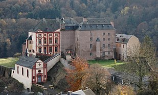
20:Schloss Malberg, a baroque castle in the Waldeifel
8:
82:. In the geographical centre is the town of
110:
36:in Germany along the middle and lower
7:
207:Mountain and hill ranges of Germany
14:
212:Geography of Rhineland-Palatinate
70:From north to south flows the
1:
32:is a landscape region of the
169:Höser, Rudolf (2024-01-17).
143:Höser, Rudolf (2024-01-21).
228:
59:and the foothills of the
125:(in German). 2022-11-29
88:collective municipality
21:
19:
96:Rhineland-Palatinate
30:Kyllburger Waldeifel
22:
42:Bitburger Gutland
219:
186:
185:
183:
182:
166:
160:
159:
157:
156:
140:
134:
133:
131:
130:
115:
227:
226:
222:
221:
220:
218:
217:
216:
202:Central Uplands
192:
191:
190:
189:
180:
178:
168:
167:
163:
154:
152:
142:
141:
137:
128:
126:
117:
116:
112:
107:
12:
11:
5:
225:
223:
215:
214:
209:
204:
194:
193:
188:
187:
161:
135:
109:
108:
106:
103:
65:Volcanic Eifel
13:
10:
9:
6:
4:
3:
2:
224:
213:
210:
208:
205:
203:
200:
199:
197:
176:
172:
165:
162:
150:
146:
139:
136:
124:
120:
114:
111:
104:
102:
99:
97:
93:
89:
85:
81:
77:
73:
68:
66:
62:
58:
54:
50:
45:
43:
39:
35:
31:
27:
18:
179:. Retrieved
174:
164:
153:. Retrieved
148:
138:
127:. Retrieved
122:
113:
100:
71:
69:
46:
41:
29:
25:
23:
177:(in German)
175:Volksfreund
151:(in German)
149:Volksfreund
123:Volksfreund
51:leaves the
34:South Eifel
196:Categories
181:2024-04-06
155:2024-04-06
129:2024-04-06
105:References
61:High Eifel
53:Snow Eifel
47:There the
78:north of
26:Waldeifel
92:Kyllburg
84:Kyllburg
76:Moselle
80:Trier
57:Eifel
72:Kyll
63:and
49:Kyll
38:Kyll
24:The
90:of
44:).
28:or
198::
173:.
147:.
121:.
98:.
184:.
158:.
132:.
Text is available under the Creative Commons Attribution-ShareAlike License. Additional terms may apply.