79:
802:
104:
235:
has 73 buildings, of which 66 are of historic significance. Architecturally diverse houses, ranging from
Georgian colonials to Queen Anne Victorians, line South Main Street north to Prince Street, where the town hall (1916 neo-Classical, formerly the town high school) begins the commercial and civic area. Three churches, built between 1868 and 1870, are prominent landmarks in that area, as is the former armory (1920, now the police station).
62:
813:
111:
86:
234:
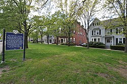
Wallingford's historic town center is set atop a long north–south ridge, along which Main Street runs. The historic district extends along Main Street from Ward Street in the south to Church Street in the north, and includes one block of commercial buildings on adjacent Center Street. The district
238:
Wallingford was founded in the 1670s, but saw its major growth as a commercial and industrial center beginning in the mid-19th century, when local businessman began manufacturing silver products. The
Simpson and Wallace families that dominated this business also built commercial blocks in the
222:. Extending mainly along North and South Main Streets, the district includes high-quality residential, civic, commercial, and institutional architecture from the mid-18th to early 20th centuries, reflecting the community's growth. The district was listed on the
691:
842:
786:
722:
706:
847:
248:
696:
781:
727:
368:
748:
650:
681:
615:
580:
655:
560:
520:
345:
620:
610:
605:
585:
701:
535:
450:
570:
565:
440:
660:
625:
530:
505:
645:
595:
575:
550:
540:
525:
515:
500:
480:
455:
445:
435:
665:
640:
545:
485:
465:
460:
430:
420:
600:
555:
495:
470:
425:
732:
630:
510:
475:
686:
635:
590:
490:
398:
383:
144:
338:
414:
78:
103:
816:
331:
239:
downtown area that still stand. Wallingford's primary commercial center migrated westward to be nearer the railroad right-of-way in the early 20th century.
806:
378:
48:
354:
276:
223:
39:
769:
837:
774:
753:
219:
132:
388:
393:
373:
302:
281:
299:"National Register of Historic Places Inventory/Nomination: Wallingford Center Historic District"
315:
298:
323:
61:
198:
831:
787:
University and college buildings listed on the
National Register of Historic Places
249:
National
Register of Historic Places listings in New Haven County, Connecticut
843:
Historic districts on the
National Register of Historic Places in Connecticut
159:
146:
848:
National
Register of Historic Places in New Haven County, Connecticut
782:
List of jails and prisons on the
National Register of Historic Places
271:
327:
218:
encompasses the historic 18th and 19th-century town center of
66:
View of the town's historic parade ground and adjacent houses
110:
85:
762:
741:
715:
674:
407:
384:
History of the
National Register of Historic Places
361:
204:
191:
183:
175:
138:
127:
187:Colonial, Mid 19th Century Revival, Late Victorian
415:List of U.S. National Historic Landmarks by state
807:National Register of Historic Places portal
131:Roughly, Main St. from Ward St. to Church St.,
16:Historic district in Connecticut, United States
339:
8:
346:
332:
324:
60:
355:U.S. National Register of Historic Places
293:
291:
40:U.S. National Register of Historic Places
260:
272:"National Register Information System"
266:
264:
23:
7:
277:National Register of Historic Places
224:National Register of Historic Places
216:Wallingford Center Historic District
32:Wallingford Center Historic District
770:National Historic Preservation Act
14:
812:
811:
800:
109:
102:
84:
77:
723:Federated States of Micronesia
369:Architectural style categories
193:
1:
118:Show map of the United States
21:United States historic place
864:
775:Historic Preservation Fund
754:American Legation, Morocco
795:
716:Lists by associated state
192:NRHP reference
71:
59:
55:
46:
37:
30:
26:
838:Wallingford, Connecticut
697:Northern Mariana Islands
220:Wallingford, Connecticut
184:Architectural style
133:Wallingford, Connecticut
230:Description and history
93:Show map of Connecticut
692:Minor Outlying Islands
675:Lists by insular areas
389:Keeper of the Register
49:U.S. Historic district
394:National Park Service
374:Contributing property
316:accompanying pictures
303:National Park Service
282:National Park Service
179:31 acres (13 ha)
160:41.45306°N 72.82056°W
749:District of Columbia
284:. November 2, 2013.
165:41.45306; -72.82056
156: /
825:
824:
379:Historic district
212:
211:
855:
815:
814:
805:
804:
803:
728:Marshall Islands
348:
341:
334:
325:
318:
313:
311:
309:
295:
286:
285:
268:
208:December 2, 1993
195:
171:
170:
168:
167:
166:
161:
157:
154:
153:
152:
149:
119:
113:
112:
106:
94:
88:
87:
81:
64:
24:
863:
862:
858:
857:
856:
854:
853:
852:
828:
827:
826:
821:
801:
799:
791:
758:
737:
711:
670:
403:
357:
352:
322:
321:
307:
305:
297:
296:
289:
270:
269:
262:
257:
245:
232:
164:
162:
158:
155:
150:
147:
145:
143:
142:
123:
122:
121:
120:
117:
116:
115:
114:
97:
96:
95:
92:
91:
90:
89:
67:
51:
42:
33:
22:
17:
12:
11:
5:
861:
859:
851:
850:
845:
840:
830:
829:
823:
822:
820:
819:
809:
796:
793:
792:
790:
789:
784:
779:
778:
777:
766:
764:
760:
759:
757:
756:
751:
745:
743:
739:
738:
736:
735:
730:
725:
719:
717:
713:
712:
710:
709:
707:Virgin Islands
704:
699:
694:
689:
684:
682:American Samoa
678:
676:
672:
671:
669:
668:
663:
658:
653:
648:
643:
638:
633:
628:
623:
618:
616:South Carolina
613:
608:
603:
598:
593:
588:
583:
581:North Carolina
578:
573:
568:
563:
558:
553:
548:
543:
538:
533:
528:
523:
518:
513:
508:
503:
498:
493:
488:
483:
478:
473:
468:
463:
458:
453:
448:
443:
438:
433:
428:
423:
418:
411:
409:
408:Lists by state
405:
404:
402:
401:
399:Property types
396:
391:
386:
381:
376:
371:
365:
363:
359:
358:
353:
351:
350:
343:
336:
328:
320:
319:
287:
259:
258:
256:
253:
252:
251:
244:
241:
231:
228:
210:
209:
206:
202:
201:
196:
189:
188:
185:
181:
180:
177:
173:
172:
140:
136:
135:
129:
125:
124:
108:
107:
101:
100:
99:
98:
83:
82:
76:
75:
74:
73:
72:
69:
68:
65:
57:
56:
53:
52:
47:
44:
43:
38:
35:
34:
31:
28:
27:
20:
15:
13:
10:
9:
6:
4:
3:
2:
860:
849:
846:
844:
841:
839:
836:
835:
833:
818:
810:
808:
798:
797:
794:
788:
785:
783:
780:
776:
773:
772:
771:
768:
767:
765:
761:
755:
752:
750:
747:
746:
744:
740:
734:
731:
729:
726:
724:
721:
720:
718:
714:
708:
705:
703:
700:
698:
695:
693:
690:
688:
685:
683:
680:
679:
677:
673:
667:
664:
662:
659:
657:
656:West Virginia
654:
652:
649:
647:
644:
642:
639:
637:
634:
632:
629:
627:
624:
622:
619:
617:
614:
612:
609:
607:
604:
602:
599:
597:
594:
592:
589:
587:
584:
582:
579:
577:
574:
572:
569:
567:
564:
562:
561:New Hampshire
559:
557:
554:
552:
549:
547:
544:
542:
539:
537:
534:
532:
529:
527:
524:
522:
521:Massachusetts
519:
517:
514:
512:
509:
507:
504:
502:
499:
497:
494:
492:
489:
487:
484:
482:
479:
477:
474:
472:
469:
467:
464:
462:
459:
457:
454:
452:
449:
447:
444:
442:
439:
437:
434:
432:
429:
427:
424:
422:
419:
416:
413:
412:
410:
406:
400:
397:
395:
392:
390:
387:
385:
382:
380:
377:
375:
372:
370:
367:
366:
364:
360:
356:
349:
344:
342:
337:
335:
330:
329:
326:
317:
304:
300:
294:
292:
288:
283:
279:
278:
273:
267:
265:
261:
254:
250:
247:
246:
242:
240:
236:
229:
227:
225:
221:
217:
207:
205:Added to NRHP
203:
200:
197:
190:
186:
182:
178:
174:
169:
141:
137:
134:
130:
126:
105:
80:
70:
63:
58:
54:
50:
45:
41:
36:
29:
25:
19:
621:South Dakota
611:Rhode Island
606:Pennsylvania
586:North Dakota
306:. Retrieved
275:
237:
233:
215:
213:
18:
742:Other areas
702:Puerto Rico
536:Mississippi
451:Connecticut
163: /
139:Coordinates
832:Categories
651:Washington
571:New Mexico
566:New Jersey
441:California
255:References
151:72°49′14″W
148:41°27′11″N
661:Wisconsin
626:Tennessee
531:Minnesota
506:Louisiana
226:in 1993.
817:Category
646:Virginia
596:Oklahoma
576:New York
551:Nebraska
541:Missouri
526:Michigan
516:Maryland
501:Kentucky
481:Illinois
456:Delaware
446:Colorado
436:Arkansas
308:June 10,
243:See also
199:93001242
128:Location
763:Related
666:Wyoming
641:Vermont
546:Montana
486:Indiana
466:Georgia
461:Florida
431:Arizona
421:Alabama
601:Oregon
556:Nevada
496:Kansas
471:Hawaii
426:Alaska
362:Topics
733:Palau
631:Texas
511:Maine
476:Idaho
314:With
687:Guam
636:Utah
591:Ohio
491:Iowa
310:2021
214:The
176:Area
194:No.
834::
301:.
290:^
280:.
274:.
263:^
417::
347:e
340:t
333:v
312:.
Text is available under the Creative Commons Attribution-ShareAlike License. Additional terms may apply.