240:. Track improvements were made during the 1870s and the park was redesigned in 1885. These tracks were used to transport war weapons and machineries for war efforts. Also the south of the circle along 23rd street was used as a Union army encampment, named Camp Fry. Camp Fry served as a camp for wounded soldiers to recuperate. After the civil war, the camp was dismantled. St. Paul's Episcopal church, popularly known as Old St. Paul's Church was built in 1866 and was the first church built around the circle at the corner of 23rd street. With the influx of the African American population after the civil war, the church was built to act as a form of missionary to the people. St. Ann's Infant Asylum was also present during the 1860s and it occupied the building that the British Legation once occupied.
216:
in 1850. Although the avenues were developing, 23RD and K Streets were yet to be properly developed. Also the
Washington Circle, itself, was very bland during this period, it had not been beautified and was known as a dangerous part of the city. The 1851 map shows that K Street, known as the area's broadest thoroughfare also became paved. The map also illustrates the development of the circle's surrounding with over thirty-three buildings between the New Hampshire and Pennsylvania intersection. Carefully observing the 1852 map, one can infer that not much had changed from the previous year's map. The growth of Washington Circle was indeed a very slow one and this may be, because of the unwillingness of the congress to back up the development of the city.
212:’s map in 1791 (Washington Circle, as well as the majority of the map, is unlabelled in L’Enfant's original plan. Looking at L’Enfant's Map, one can see that streets were laid in form of grids and there were many intersections around the circle. In addition to the street grids, there are a couple of other circles beside the circle. These features indicate the strategic positioning of the circle within the city. The circle intersects four major roads. On the northeastern side of the circle there's a vista along New Hampshire Avenue that leads to DuPont Circle while on the southeastern side, there is another pleasant vista from Pennsylvania avenue that leads to the White house. The circle also intersects 23rd and K streets.
48:
249:
257:
and most buildings served as stables or sheds. The neighborhood around
Washington Circle changed during the 20th century with the relocation of the George Washington University to the Foggy Bottom campus. Foggy Bottom (including the area surrounding Washington Circle) was meant to be a residential area. With the new presence of the George Washington University which was brought on during the twentieth century, the area became much more institutionalized as seen through the
29:
294:
55:
319:, was installed in the center of the circle on February 22, 1860. The Continental Congress voted to build the statue in George Washington's honor in 1783 but the statue was not commissioned until 1853 at a total cost of $ 60,000. Mills depicted General Washington in the heroic, idealized Romantic style, reminiscent of
215:
In 1850, Washington Circle and its surroundings were gradually developing. Looking at the 1850 map of
Washington Circle, one can see that both New Hampshire Avenue and Pennsylvania Avenue were more pronounced on the map than they were in L’Enfant's map. This shows that the two avenues were well paved
256:
In the 1892 map of
Washington Circle, one can see the detailed structure of buildings present then. The majority of the buildings present during this period were built with stone. Between New Hampshire Avenue and K Street, most of the buildings were built with brick. There were very few green houses
1293:
302:
1303:
694:
1262:
1237:
1232:
47:
1283:
783:
607:
584:
1323:
1176:
1214:
703:
282:
813:
687:
88:
992:
924:
592:
170:
1318:
1257:
368:
258:
1313:
1308:
1007:
203:
1298:
1189:
1136:
1126:
1035:
909:
828:
818:
680:
393:
904:
899:
657:
270:
1227:
1222:
1166:
1141:
1055:
662:
522:
1247:
1199:
722:
360:
233:
560:
Keck, Andrew S. (1971–1972). "A Toast to the Union: Clark Mills' Equestrian Statue of Andrew
Jackson in Lafayette Square".
997:
717:
142:
123:
488:
455:
174:
81:
773:
763:
758:
753:
748:
199:
162:
139:
325:
154:
158:
972:
517:
385:
236:
tracks were laid around
Washington Circle, but were not properly maintained during the turbulent years of the
277:
complex is located directly south of the circle, near The George
Washington University Hospital. The closest
274:
308:
248:
1288:
1015:
949:
944:
621:
408:"Map of Washington 1850". Retrieved from the Washingtonian Collection of The Martin Luther King Library.
330:
1184:
889:
879:
853:
823:
166:
209:
1151:
919:
884:
843:
838:
583:
District of
Columbia, Office of Planning, State Historic Preservation Office (September 30, 2009).
493:
320:
316:
625:
1060:
1040:
1030:
793:
565:
449:
237:
225:
329:. Washington's horse was modeled on a wild horse that was captured on the plains of Kansas. The
28:
601:
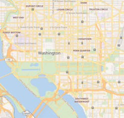
484:
364:
312:
1204:
1194:
1146:
858:
444:. Box 7 folder 22, Special Collection Center, Gellman Library, George Washington University.
293:
278:
146:
74:
672:
430:"The Map of Washington 1852". Washingtonian Collection from The Martin Luther King Library.
1121:
1075:
1020:
848:
333:
now maintains
Washington Circle's park, the public space surrounding Washington's statue.
34:
228:
was fought from 1861 to 1865 and
Washington Circle was an instrumental location for the
1095:
1080:
803:
798:
732:
727:
419:"Map of Washington 1951". Washingtonian Collection from The Martin Luther King Library.
135:
1277:
1252:
1242:
1156:
1131:
1090:
1085:
1045:
1025:
977:
939:
934:
547:
Washington Sculpture: A Cultural History of Outdoor Sculpture in the Nation's Capital
178:
1161:
1070:
1065:
1050:
987:
967:
808:
150:
1100:
982:
833:
470:
229:
518:"Boston Properties signs lease for old George Washington University Hospital"
103:
90:
768:
666:
569:
292:
247:
676:
669:", 7 photos, 16 data pages, 1 photo caption page
161:
section in Washington. It is the intersection of 23rd Street,
626:"Statues, Monuments, and Memorials in National Capital Parks"
549:. Baltimore: The Johns Hopkins University Press. p. 480.
562:
Records of the Columbia Historical Society, Washington, D.C
303:
Equestrian statue of George Washington (Washington Circle)
653:
185:
a tunnel, while the service lanes intersect the circle.
1294:
Historic American Buildings Survey in Washington, D.C.
149:, United States. It is located on the border of the
1213:
1175:
1114:
1006:
960:
867:
782:
741:
710:
442:
Foot note from Washington Circle and Camp Fry, 1863
357:
L'Enfant's Legacy: Public Open Spaces in Washington
119:
80:
70:
21:
585:"District of Columbia Inventory of Historic Sites"
177:campus. The through lanes of K Street (which are
1304:Squares, plazas, and circles in Washington, D.C.
688:
297:Sculpture of George Washington by Clark Mills
8:
606:: CS1 maint: multiple names: authors list (
261:, located on the southeast end of the park.
489:"Square 54, a New Site for an Ongoing Feud"
386:"Washington Circle (Reservation Number 26)"
695:
681:
673:
18:
54:
704:Streets and highways of Washington, D.C.
397:. Washington, D.C.: Library of Congress.
350:
348:
346:
307:A bronze equestrian statue, sculpted by
173:, N.W. It borders many buildings of the
1284:1856 establishments in Washington, D.C.
342:
273:(GWU) adjoins Washington Circle. GWU's
599:
447:
157:neighborhoods, which is a part of the
259:George Washington University Hospital
208:Washington Circle was first drawn on
7:
516:Castro, Melissa (February 8, 2008).
204:List of circles in Washington, D.C.
663:Historic American Buildings Survey
497:. washingtonpost.com. pp. D01
394:Historic American Buildings Survey
16:Traffic circle in Washington, D.C.
14:
1324:Road tunnels in the United States
658:Advisory Neighborhood Commission
271:The George Washington University
69:
62:Location within Washington, D.C.
53:
46:
27:
181:) travel underneath the circle
361:Johns Hopkins University Press
289:Sculpture of George Washington
1:
998:Martin Luther King Jr. Avenue
1319:George Washington University
526:. washington.bizjournals.com
384:Barthold, Elizabeth (1993).
315:riding his horse during the
175:George Washington University
1314:Tunnels in Washington, D.C.
1309:Streets in Washington, D.C.
523:Washington Business Journal
355:Bednar, Michael J. (2006).
269:The Foggy Bottom campus of
200:History of Washington, D.C.
1340:
1190:George Washington Memorial
326:Napoleon Crossing the Alps
300:
197:
194:Early- to mid-19th century
1299:Parks in Washington, D.C.
665:(HABS) No. DC-688, "
232:during the war. In 1862,
41:
33:Washington Circle during
26:
973:Black Lives Matter Plaza
454:: CS1 maint: location (
252:Washington Circle's park
124:Foggy Bottom–GWU station
1200:Rock Creek and Potomac
656:, Washington Circle's
298:
253:
622:National Park Service
545:Goode, James (2008).
331:National Park Service
321:Jacques-Louis David's
296:
251:
120:Public transit access
167:New Hampshire Avenue
993:MacArthur Boulevard
494:The Washington Post
487:(August 12, 2005).
317:Battle of Princeton
171:Pennsylvania Avenue
100: /
564:. 71–72: 300–303.
485:Pearlstein, Steven
299:
254:
226:American Civil War
1271:
1270:
1248:Kenilworth Avenue
931:President's Park
667:Washington Circle
624:(July 31, 2003).
469:St. Paul Parish.
370:978-0-8018-8318-7
313:George Washington
132:Washington Circle
129:
128:
104:38.9025°N 77.05°W
22:Washington Circle
1331:
876:Capitol Streets
742:Lettered streets
711:Numbered streets
697:
690:
683:
674:
641:
640:
638:
636:
618:
612:
611:
605:
597:
589:
580:
574:
573:
557:
551:
550:
542:
536:
535:
533:
531:
513:
507:
506:
504:
502:
481:
475:
474:
466:
460:
459:
453:
445:
438:
432:
431:
427:
421:
420:
416:
410:
409:
405:
399:
398:
390:
381:
375:
374:
352:
283:Foggy Bottom–GWU
279:Washington Metro
147:Washington, D.C.
115:
114:
112:
111:
110:
105:
101:
98:
97:
96:
93:
75:Washington, D.C.
57:
56:
50:
31:
19:
1339:
1338:
1334:
1333:
1332:
1330:
1329:
1328:
1274:
1273:
1272:
1267:
1209:
1171:
1110:
1002:
956:
896:Border Avenues
869:
863:
785:
778:
737:
706:
701:
650:
645:
644:
634:
632:
620:
619:
615:
598:
593:planning.dc.gov
587:
582:
581:
577:
559:
558:
554:
544:
543:
539:
529:
527:
515:
514:
510:
500:
498:
483:
482:
478:
468:
467:
463:
446:
440:
439:
435:
429:
428:
424:
418:
417:
413:
407:
406:
402:
388:
383:
382:
378:
371:
354:
353:
344:
339:
305:
291:
267:
246:
222:
210:Pierre L’Enfant
206:
196:
191:
109:38.9025; -77.05
108:
106:
102:
99:
94:
91:
89:
87:
86:
66:
65:
64:
63:
60:
59:
58:
37:
17:
12:
11:
5:
1337:
1335:
1327:
1326:
1321:
1316:
1311:
1306:
1301:
1296:
1291:
1286:
1276:
1275:
1269:
1268:
1266:
1265:
1260:
1255:
1250:
1245:
1240:
1235:
1230:
1225:
1219:
1217:
1211:
1210:
1208:
1207:
1202:
1197:
1192:
1187:
1181:
1179:
1173:
1172:
1170:
1169:
1164:
1159:
1154:
1149:
1144:
1139:
1134:
1129:
1124:
1118:
1116:
1112:
1111:
1109:
1108:
1103:
1098:
1093:
1088:
1083:
1078:
1073:
1068:
1063:
1058:
1053:
1048:
1043:
1038:
1033:
1028:
1023:
1018:
1016:Anna J. Cooper
1012:
1010:
1004:
1003:
1001:
1000:
995:
990:
985:
980:
975:
970:
964:
962:
958:
957:
955:
954:
953:
952:
950:West Executive
947:
945:East Executive
942:
937:
929:
928:
927:
922:
916:National Mall
914:
913:
912:
907:
902:
894:
893:
892:
887:
882:
873:
871:
868:Border avenues
865:
864:
862:
861:
856:
851:
846:
841:
836:
831:
826:
821:
816:
811:
806:
801:
796:
790:
788:
780:
779:
777:
776:
771:
766:
761:
756:
751:
745:
743:
739:
738:
736:
735:
733:18th Street NW
730:
728:16th Street NW
725:
720:
714:
712:
708:
707:
702:
700:
699:
692:
685:
677:
671:
670:
660:
649:
648:External links
646:
643:
642:
613:
575:
552:
537:
508:
476:
461:
433:
422:
411:
400:
376:
369:
341:
340:
338:
335:
311:and depicting
301:Main article:
290:
287:
266:
263:
245:
242:
221:
218:
195:
192:
190:
187:
136:traffic circle
127:
126:
121:
117:
116:
84:
78:
77:
72:
68:
67:
61:
52:
51:
45:
44:
43:
42:
39:
38:
32:
24:
23:
15:
13:
10:
9:
6:
4:
3:
2:
1336:
1325:
1322:
1320:
1317:
1315:
1312:
1310:
1307:
1305:
1302:
1300:
1297:
1295:
1292:
1290:
1287:
1285:
1282:
1281:
1279:
1264:
1261:
1259:
1256:
1254:
1253:Potomac River
1251:
1249:
1246:
1244:
1241:
1239:
1236:
1234:
1231:
1229:
1226:
1224:
1221:
1220:
1218:
1216:
1212:
1206:
1203:
1201:
1198:
1196:
1193:
1191:
1188:
1186:
1183:
1182:
1180:
1178:
1174:
1168:
1165:
1163:
1160:
1158:
1155:
1153:
1150:
1148:
1145:
1143:
1140:
1138:
1135:
1133:
1130:
1128:
1125:
1123:
1120:
1119:
1117:
1113:
1107:
1104:
1102:
1099:
1097:
1094:
1092:
1089:
1087:
1084:
1082:
1079:
1077:
1074:
1072:
1069:
1067:
1064:
1062:
1059:
1057:
1054:
1052:
1049:
1047:
1044:
1042:
1039:
1037:
1034:
1032:
1029:
1027:
1024:
1022:
1019:
1017:
1014:
1013:
1011:
1009:
1005:
999:
996:
994:
991:
989:
986:
984:
981:
979:
978:Columbia Road
976:
974:
971:
969:
966:
965:
963:
961:Other streets
959:
951:
948:
946:
943:
941:
938:
936:
933:
932:
930:
926:
923:
921:
918:
917:
915:
911:
908:
906:
903:
901:
898:
897:
895:
891:
888:
886:
883:
881:
878:
877:
875:
874:
872:
866:
860:
857:
855:
854:West Virginia
852:
850:
847:
845:
842:
840:
837:
835:
832:
830:
827:
825:
824:New Hampshire
822:
820:
817:
815:
814:Massachusetts
812:
810:
807:
805:
802:
800:
797:
795:
792:
791:
789:
787:
781:
775:
772:
770:
767:
765:
762:
760:
757:
755:
752:
750:
747:
746:
744:
740:
734:
731:
729:
726:
724:
721:
719:
716:
715:
713:
709:
705:
698:
693:
691:
686:
684:
679:
678:
675:
668:
664:
661:
659:
655:
652:
651:
647:
631:
627:
623:
617:
614:
609:
603:
595:
594:
586:
579:
576:
571:
567:
563:
556:
553:
548:
541:
538:
525:
524:
519:
512:
509:
496:
495:
490:
486:
480:
477:
472:
465:
462:
457:
451:
443:
437:
434:
426:
423:
415:
412:
404:
401:
396:
395:
387:
380:
377:
372:
366:
362:
359:. Baltimore:
358:
351:
349:
347:
343:
336:
334:
332:
328:
327:
322:
318:
314:
310:
304:
295:
288:
286:
284:
280:
276:
272:
264:
262:
260:
250:
243:
241:
239:
235:
231:
227:
220:Civil War era
219:
217:
213:
211:
205:
201:
193:
188:
186:
184:
180:
179:U.S. Route 29
176:
172:
168:
164:
160:
156:
152:
148:
144:
141:
137:
133:
125:
122:
118:
113:
85:
83:
79:
76:
73:
49:
40:
36:
30:
25:
20:
1289:Foggy Bottom
1185:Clara Barton
1152:Mount Vernon
1105:
988:Klingle Road
968:Benning Road
925:Independence
920:Constitution
844:Rhode Island
839:Pennsylvania
635:November 29,
633:. Retrieved
629:
616:
591:
578:
561:
555:
546:
540:
530:November 29,
528:. Retrieved
521:
511:
501:November 29,
499:. Retrieved
492:
479:
464:
441:
436:
425:
414:
403:
392:
379:
356:
324:
306:
268:
265:Neighborhood
255:
223:
214:
207:
182:
151:Foggy Bottom
131:
130:
1228:12th Street
1215:Expressways
1061:Observatory
1041:Dave Thomas
1031:Chevy Chase
983:Embassy Row
870:and streets
794:Connecticut
784:State-named
723:14th Street
309:Clark Mills
281:station is
244:Present day
107: /
82:Coordinates
1278:Categories
1238:Center Leg
1223:9th Street
1106:Washington
718:7th Street
337:References
234:streetcars
230:Union Army
198:See also:
95:77°03′00″W
92:38°54′09″N
1263:Southwest
1258:Southeast
1233:Anacostia
1147:McPherson
1137:Lafayette
859:Wisconsin
471:"History"
450:cite book
323:painting
275:Square 54
238:Civil War
140:northwest
1243:E Street
1205:Suitland
1195:Oxon Run
1177:Parkways
1127:Franklin
1122:Farragut
1076:Sheridan
1036:Columbus
1021:Banneker
910:Southern
849:Virginia
829:New York
819:Missouri
786:roadways
774:U Street
769:P Street
764:M Street
759:K Street
754:H Street
749:F Street
602:cite web
570:40067778
163:K Street
155:West End
143:quadrant
71:Location
1162:Stanton
1142:Lincoln
1132:Freedom
1115:Squares
1096:Truxton
1081:Sherman
1008:Circles
940:Madison
935:Jackson
905:Eastern
900:Western
804:Georgia
799:Florida
630:nps.gov
189:History
138:in the
1157:Seward
1091:Thomas
1086:Tenley
1046:Dupont
1026:Barney
654:ANC 2A
568:
367:
169:, and
159:Ward 2
35:spring
1167:Union
1071:Scott
1066:Peace
1056:Logan
1051:Grant
890:South
880:North
809:Maine
588:(PDF)
566:JSTOR
389:(PDF)
134:is a
1101:Ward
885:East
834:Ohio
637:2009
608:link
532:2009
503:2009
456:link
365:ISBN
224:The
202:and
153:and
183:via
145:of
1280::
628:.
604:}}
600:{{
590:.
520:.
491:.
452:}}
448:{{
391:.
363:.
345:^
285:.
165:,
696:e
689:t
682:v
639:.
610:)
596:.
572:.
534:.
505:.
473:.
458:)
373:.
Text is available under the Creative Commons Attribution-ShareAlike License. Additional terms may apply.