182:
213:(I-95). Its northernmost section, between Auburn Street and Summit Street, is known as Washington Avenue Extension. It continues solely as Washington Avenue past Riverside Street, close to I-95, before turning southeasterly. It meets Auburn Street again near the Northgate Plaza, running alongside it to the south for the final few yards of Auburn Street's course. Allen Avenue picks up the SR 100 designation at the next intersection as it continues southwesterly.
1035:
79:
56:
153:
between exits 8 and 9. It is the main artery for traffic entering and leaving
Portland to and from the north via city streets, and has been described as a "gateway to the Portland peninsula." Washington Avenue passes to the north of
228:
in East
Deering, passing Presumpscot Street, before reaching an intersection with Bates Street, Veranda Street and the exit 9 ramps to and from I-295. It continues, in parallel with I-295 and US 1, on the southbound exit lanes of
956:
856:
256:'s routes 9A and 9B (North Deering/West Falmouth) serves Washington Avenue on its northern section; they are joined by route 7 on the southern section.
979:
492:
1009:
558:
18:
323:
1060:
553:
751:
325:
Auditor's ... Annual Report ...: With the Mayor's
Address, and Annual Reports of the Several Departments, Made to the City Council ...
836:
826:
796:
761:
234:
142:
119:
974:
781:
646:
217:
989:
935:
665:
841:
684:
801:
786:
485:
1014:
984:
621:
339:
297:
705:
611:
536:
390:
364:
233:
between exits 9 and 8, where it exits on the left ramp of two en route to and from downtown
Portland, terminating at
710:
531:
1038:
548:
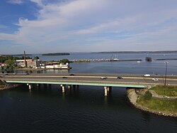
543:
478:
816:
895:
776:
273:
253:
210:
202:
146:
994:
885:
675:
616:
596:
206:
194:
170:
141:, United States. It runs for around 5.25 miles (8.45 km), from Auburn Street in the northwest to
1065:
999:
925:
915:
756:
606:
190:
166:
82:
1004:
636:
586:
221:
181:
905:
601:
461:
930:
900:
866:
851:
811:
771:
766:
670:
591:
242:
230:
225:
155:
150:
61:
298:"Hannaford, Market Basket, Shaw's, Walmart: Check out the Press Herald's comparison shopping"
1019:
940:
746:
736:
715:
626:
966:
695:
573:
563:
526:
521:
516:
502:
169:
for its entire course. It picks up the designation from Auburn Street, which continues as
138:
100:
414:
920:
846:
831:
741:
731:
657:
1054:
890:
821:
791:
581:
198:
159:
806:
680:
700:
631:
238:
220:, past Canco Road and across Fall Brook, to an intersection with Ocean Avenue (
470:
438:
33:
20:
690:
415:"Route 9A / 9B - N. Deering/WEST FALMOUTH | Greater Portland Transit, ME"
55:
180:
474:
365:"Washington Avenue | The Food and Drink Capital of Maine"
241:. Part of its final section, up to its intersection with
391:"How Portland's Washington Avenue Became All About Food"
965:
949:
875:
724:
645:
572:
509:
439:"Route 7 - Falmouth | Greater Portland Transit, ME"
245:(SR 100), has become notable for its restaurants.
173:south of its intersection with Washington Avenue.
115:
107:
96:
88:
73:
64:via both the northbound and southbound exit lanes
145:in the southeast. It continues in parallel with
340:"Maine Places to Love: Inner Washington Avenue"
193:designation from Auburn Street (which is also
486:
224:). It then approaches the northern shores of
8:
48:
493:
479:
471:
274:"Streetscape: Washington Avenue, Portland"
47:
265:
185:Sherburne House, 1024 Washington Avenue
7:
216:Washington Avenue continues through
14:
975:Maine College of Art & Design
1034:
1033:
389:Schwalje, Kaitlyn (2021-04-07).
77:
54:
1:
165:Washington Avenue is part of
1010:Portland Arts and Technology
985:University of Southern Maine
725:Bridges, streets and squares
462:"Washington Ave Streetscape"
189:Forest Avenue picks up the
92:5.25 mi (8.45 km)
1082:
1061:Streets in Portland, Maine
60:Washington Avenue crosses
1028:
980:University of New England
127:Street in Portland, Maine
69:
53:
857:Veterans Memorial Bridge
237:at the southern edge of
990:Portland, Maine schools
896:Portland Hearts of Pine
322:Portland (Me.) (1916).
137:) is a major street in
133:(known colloquially as
278:Ransom Consulting, LLC
254:Greater Portland Metro
186:
886:Maine Mariners (ECHL)
817:Martin's Point Bridge
622:Little Diamond Island
249:Public transportation
184:
162:passes to its south.
34:43.70090°N 70.28919°W
926:Maine Mariners (AHL)
612:Great Diamond Island
607:Fore River Sanctuary
197:) just south of the
50:
39:43.70090; -70.28919
30: /
906:Maine Roller Derby
464:– City of Portland
395:Down East Magazine
187:
116:Southeast end
108:Northwest end
1048:
1047:
950:Metropolitan area
931:Portland Blue Sox
901:Portland Sea Dogs
867:Western Promenade
862:Washington Avenue
812:Longfellow Square
772:Eastern Promenade
767:Cumberland Avenue
752:Commercial Street
243:Cumberland Avenue
201:, which connects
131:Washington Avenue
125:
124:
49:Washington Avenue
1073:
1037:
1036:
957:Greater Portland
941:Portland Pirates
916:Portland Phoenix
747:Casco Bay Bridge
737:Baxter Boulevard
716:Woodfords Corner
627:Mackworth Island
495:
488:
481:
472:
465:
459:
453:
452:
450:
449:
435:
429:
428:
426:
425:
411:
405:
404:
402:
401:
386:
380:
379:
377:
376:
361:
355:
354:
352:
351:
336:
330:
329:
319:
313:
312:
310:
309:
294:
288:
287:
285:
284:
270:
81:
80:
58:
51:
45:
44:
42:
41:
40:
35:
31:
28:
27:
26:
23:
1081:
1080:
1076:
1075:
1074:
1072:
1071:
1070:
1051:
1050:
1049:
1044:
1024:
961:
945:
936:Portland Pilots
871:
837:St. John Street
827:Monument Square
797:Franklin Street
777:Exchange Street
762:Congress Street
757:Congress Square
720:
696:Morrills Corner
641:
568:
505:
503:Portland, Maine
499:
469:
468:
460:
456:
447:
445:
437:
436:
432:
423:
421:
413:
412:
408:
399:
397:
388:
387:
383:
374:
372:
363:
362:
358:
349:
347:
338:
337:
333:
321:
320:
316:
307:
305:
296:
295:
291:
282:
280:
272:
271:
267:
262:
251:
235:Congress Street
195:State Route 100
179:
171:State Route 100
143:Congress Street
139:Portland, Maine
128:
120:Congress Street
101:Portland, Maine
78:
65:
38:
36:
32:
29:
24:
21:
19:
17:
16:
12:
11:
5:
1079:
1077:
1069:
1068:
1063:
1053:
1052:
1046:
1045:
1043:
1042:
1029:
1026:
1025:
1023:
1022:
1017:
1012:
1007:
1002:
997:
992:
987:
982:
977:
971:
969:
963:
962:
960:
959:
953:
951:
947:
946:
944:
943:
938:
933:
928:
923:
921:Maine Mammoths
918:
913:
909:
908:
903:
898:
893:
888:
883:
879:
877:
873:
872:
870:
869:
864:
859:
854:
852:Tukey's Bridge
849:
847:Stevens Avenue
844:
839:
834:
832:Moulton Street
829:
824:
819:
814:
809:
804:
799:
794:
789:
784:
782:Federal Street
779:
774:
769:
764:
759:
754:
749:
744:
742:Boothby Square
739:
734:
732:Andrews Square
728:
726:
722:
721:
719:
718:
713:
708:
703:
698:
693:
688:
678:
676:Deering Center
673:
668:
663:
660:
655:
651:
649:
643:
642:
640:
639:
634:
629:
624:
619:
614:
609:
604:
599:
597:Cushing Island
594:
589:
584:
578:
576:
570:
569:
567:
566:
564:Transportation
561:
556:
554:Notable people
551:
546:
541:
540:
539:
529:
524:
519:
513:
511:
507:
506:
500:
498:
497:
490:
483:
475:
467:
466:
454:
430:
406:
381:
356:
331:
314:
289:
264:
263:
261:
258:
250:
247:
231:Tukey's Bridge
203:Interstate 295
191:State Route 26
178:
175:
167:State Route 26
151:Tukey's Bridge
149:as it crosses
147:Interstate 295
135:Washington Ave
126:
123:
122:
117:
113:
112:
109:
105:
104:
98:
94:
93:
90:
86:
85:
75:
71:
70:
67:
66:
62:Tukey's Bridge
59:
13:
10:
9:
6:
4:
3:
2:
1078:
1067:
1064:
1062:
1059:
1058:
1056:
1041:
1040:
1031:
1030:
1027:
1021:
1018:
1016:
1013:
1011:
1008:
1006:
1003:
1001:
998:
996:
993:
991:
988:
986:
983:
981:
978:
976:
973:
972:
970:
968:
964:
958:
955:
954:
952:
948:
942:
939:
937:
934:
932:
929:
927:
924:
922:
919:
917:
914:
911:
910:
907:
904:
902:
899:
897:
894:
892:
891:Maine Celtics
889:
887:
884:
881:
880:
878:
874:
868:
865:
863:
860:
858:
855:
853:
850:
848:
845:
843:
840:
838:
835:
833:
830:
828:
825:
823:
822:Middle Street
820:
818:
815:
813:
810:
808:
805:
803:
800:
798:
795:
793:
792:Forest Avenue
790:
788:
785:
783:
780:
778:
775:
773:
770:
768:
765:
763:
760:
758:
755:
753:
750:
748:
745:
743:
740:
738:
735:
733:
730:
729:
727:
723:
717:
714:
712:
709:
707:
704:
702:
699:
697:
694:
692:
689:
686:
682:
679:
677:
674:
672:
669:
667:
666:Arts District
664:
661:
659:
656:
653:
652:
650:
648:
647:Neighborhoods
644:
638:
635:
633:
630:
628:
625:
623:
620:
618:
617:Jewell Island
615:
613:
610:
608:
605:
603:
600:
598:
595:
593:
590:
588:
585:
583:
582:Bramhall Hill
580:
579:
577:
575:
571:
565:
562:
560:
557:
555:
552:
550:
547:
545:
542:
538:
535:
534:
533:
530:
528:
525:
523:
520:
518:
515:
514:
512:
508:
504:
496:
491:
489:
484:
482:
477:
476:
473:
463:
458:
455:
444:
440:
434:
431:
420:
416:
410:
407:
396:
392:
385:
382:
370:
369:The Maine Mag
366:
360:
357:
345:
341:
335:
332:
327:
326:
318:
315:
303:
299:
293:
290:
279:
275:
269:
266:
259:
257:
255:
248:
246:
244:
240:
236:
232:
227:
223:
222:State Route 9
219:
218:North Deering
214:
212:
211:Interstate 95
208:
204:
200:
199:Falmouth Spur
196:
192:
183:
176:
174:
172:
168:
163:
161:
160:Forest Avenue
157:
152:
148:
144:
140:
136:
132:
121:
118:
114:
111:Auburn Street
110:
106:
102:
99:
95:
91:
87:
84:
76:
72:
68:
63:
57:
52:
46:
43:
1032:
876:Sports teams
861:
842:State Street
807:India Street
685:Kennedy Park
681:East Bayside
637:Peaks Island
587:Cliff Island
501:The City of
457:
446:. Retrieved
442:
433:
422:. Retrieved
418:
409:
398:. Retrieved
394:
384:
373:. Retrieved
371:. 2019-09-08
368:
359:
348:. Retrieved
346:. 2018-08-31
344:Press Herald
343:
334:
324:
317:
306:. Retrieved
304:. 2024-03-10
302:Press Herald
301:
292:
281:. Retrieved
277:
268:
252:
215:
207:U.S. Route 1
205:(I-295) and
188:
164:
134:
130:
129:
15:
1066:Munjoy Hill
802:High Street
787:Fore Street
701:Munjoy Hill
632:Munjoy Hill
443:gpmetro.org
419:gpmetro.org
239:Munjoy Hill
37: /
1055:Categories
683:(includes
602:Fore River
592:Cow Island
559:Public art
527:Government
448:2024-05-22
424:2024-05-22
400:2024-05-22
375:2024-05-22
350:2024-05-22
328:p. 7.
308:2024-05-22
283:2024-05-22
260:References
209:(US 1) to
83:SR 26
25:70°17′21″W
22:43°42′03″N
1020:Waynflete
995:Casco Bay
967:Education
691:Libbytown
671:Back Cove
574:Geography
517:Buildings
226:Back Cove
156:Back Cove
1039:Category
1015:Portland
1000:Cheverus
711:West End
706:Old Port
654:Historic
537:timeline
158:, while
97:Location
1005:Deering
882:Current
662:Current
658:Deering
532:History
522:Climate
510:General
74:Part of
912:Former
544:Mayors
103:, U.S.
89:Length
549:Media
177:Route
1057::
441:.
417:.
393:.
367:.
342:.
300:.
276:.
687:)
494:e
487:t
480:v
451:.
427:.
403:.
378:.
353:.
311:.
286:.
Text is available under the Creative Commons Attribution-ShareAlike License. Additional terms may apply.