2492:
2362:
39:
2344:
1830:
1794:
1812:
308:. The main segment runs from Massachusetts Avenue to Columbia Road, but another short segment runs from 19th Street to Florida Avenue, one block east from the main segment. The longer street was originally T Street until it was renamed in 1901. The shorter segment was originally V Street until it was renamed in 1911. There used to be a California Avenue located in
635:. It begins at Eastern Avenue, then crosses Blair Road. Later it crosses Missouri Avenue before meeting Sherman Circle, where Crittenden Street, Illinois Avenue, and 7th Street intersect. It crosses Georgia Avenue, where it exits the Petworth neighborhood. After crossing 13th Street it ends at Spring Road, right near the northern part of
488:, where it carries. The total length of the road is about 24 miles (39 km), of which 5 miles (8.0 km) are in Washington, D.C. Georgia Avenue was originally named 7th Street Extended, and later Brightwood Avenue, before receiving its present name. Prior to this, Potomac Avenue in Southeast Washington was called Georgia Avenue.
2086:
444:
Major street in that was originally known as
Boundary Street, the northern boundary of Pierre L'Enfant's original plan for the Federal City. In 1890, the city expanded beyond the borders of the original plan, and the street was renamed. The road runs from an intersection with Massachusetts Avenue and
1570:
Street which like its counterpart, Louisiana Avenue, is near the
Capitol but not in L’Enfant’s parade. The avenue was originally occupied by a canal, but now runs from Independence Avenue and E Street, and serves as a connection between Capitol Hill and Interstate 395. At one time, it was called
256:, from Canal Street in Georgetown to Wisconsin Avenue in Friendship Heights. Hayden's proposed highway was not built; the path is now the Glover-Archbold Trail and the Massachusetts-39th Trail. Instead Weaver Street and Weaver Place were renamed Arizona Avenue in 1954 after a suggestion by the
985:, and transitions to Loughboro Road at an intersection with Chain Bridge Road. Named Chain Bridge Road until 1906. A short non-contiguous section, which lies southwest of the main route of Nebraska Avenue extends off MacArthur Boulevard NW and connects with Sherier Place NW.
1173:
that is not as long or as heavily used as South Dakota Avenue. Runs from an intersection with Kansas Avenue and Blair Road to an intersection with
Sheridan and 3rd Streets. Originally continued northwest to Georgia Avenue, but a Senate bill eliminated that portion in 1912.
749:. It exists in several intermittent sections, including one running from 12th Street SW one block in a cul-de-sac in a development built over railroad tracks, from 7th to 1st Streets SW, in front of the Capitol, and as a major street running from 1st Street NE through
2059:
2248:
2032:
1848:
2194:
2140:
1902:
1766:
1716:
2221:
2113:
2005:
1978:
1689:
791:
Major traffic-carrying artery. One of only two avenues in the
District to go through three of the four quadrants and only state-named roadway to touch two of the District's borders. The largest segment begins at 19th Street SE in the
150:
for the city. However, avenues named for
Arizona, Hawaii, Mississippi, Oklahoma and Puerto Rico connect to no other state-named roadways. Avenues named for Connecticut, Georgia, Massachusetts, New Hampshire, New York,
449:
along a winding path due to the city's topography, until 9th Street where the road follows a straight trajectory. The road terminates at an intersection with H Street NE near the
Starburst Plaza intersection in
145:
While streets in
Washington, D.C. are generally laid out in a grid pattern, the state-named avenues often form diagonal connections between the city's many traffic circles and squares as envisioned in the
916:
to
Southern Avenue in Oxon Run Park, generally parallel to Alabama Avenue. One of four state-named roadways that does not connect to another state-named roadway. Before 1908, it was named Hamilton Road.
163:
and
Virginia Avenues, which travel through three of the four quadrants; it is geometrically impossible for a straight street to exist in all four quadrants, though they exist in multiple sections.
1571:
Canal Street, while a street named
Washington Drive existed along a part of the National Mall. Along with Adams Drive, it was converted to a dirt path from the Capitol to the Washington Monument.
583:
complex. This street was originally named Louisiana Avenue. The original Indiana Avenue ran from 3rd Street to 1st Street and was demolished in the mid-1960s to construct the headquarters of the
484:
north of Florida Avenue NW, which was the boundary of the Old City and is a continuation of 7th Street NW. Traveling northward, the street passes Howard University and Fort Stevens into
1350:
tracks which stretches for about five blocks from Taylor Street to the intersection of 6th and Buchanan Streets. At one time street signs named the street ""Porto Rico Avenue"".
2571:
3139:
3114:
3109:
722:
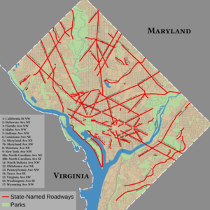
133:. Many of these roadways are major avenues that serve as the city's principal traffic arteries. Every state-named roadway is an avenue except for California Street and
2167:
1875:
100:
961:
that runs from Rhode Island Avenue to Bladensburg Road. There is also a discontinuous dead-end Montana Avenue off of Franklin Street, between 5th and 6th streets.
611:. Runs from 14th and Emerson Streets to Georgia Avenue and Varnum Street. There is also a nearby stretch from Piney Branch Road to Gallatin Road near 16th Street.
588:
1420:. A short non-contiguous section, which lies northwest of the main route of South Dakota Avenue extends off New Hampshire Avenue and terminates at a cul-de-sac.
1059:
Along with Delaware, Pennsylvania, and Maryland, one of four avenues centered on the U.S. Capitol. Segmented into two sections: one runs from Florida Avenue in
110:
761:. There are plans to make the section along the railroad tracks continuous within the Federal Center Southwest neighborhood. Until 1992, an entrance to the
3160:
1212:
memorials. In the 19th century, Ohio Avenue was a street in the Federal Triangle area. Formerly Riverside Drive, the road was renamed Ohio Drive in 1950.
3053:
1550:
to Constitution Avenue. Another section runs from 7th Street to 2nd Street, and one final section from South Capitol Street to 9th Street, alongside the
691:
The northern counterpart to Washington Avenue. Though only a few blocks from the capitol, was not in L’Enfant’s original plan. Runs from 2nd Street and
1460:
that is segmented into three sections: from Ridge Road to East Capitol Street, from Nash Street to Pennsylvania Avenue, and from 29th to 27th Streets.
1118:
473:
105:
3091:
2580:
1605:
1377:
758:
92:
2690:
2564:
773:
160:
591:. A short, noncontiguous portion of Indiana Avenue near the intersection of First Street and C Street is all that remains of the original route.
2869:
2801:
1376:, goes through Logan Circle, exits the District in Woodridge, and continues for a couple miles in Maryland. For much of its length, it carries
1358:
159:, often as state highways, but none of the state-named avenues continue into Virginia. Most avenues exist in one or two quadrants, except for
3134:
664:
3165:
1551:
1256:
to Western Avenue. Until 1938, it was named Daniel Road. The original Oregon Avenue was in Shaw and was renamed Swann Street NW in 1938.
804:. This main segment runs 8.4 miles in Washington and an additional 2.3 miles in Maryland. A smaller segment (1.6 miles) runs east of the
2884:
1663:
1497:
1319:
1028:
301:
3066:
3013:
3003:
2912:
2786:
2705:
2695:
2557:
1315:
1209:
1095:
636:
576:
509:
481:
371:
2781:
2776:
2397:
2322:
584:
513:
1232:
that runs from 21st Street to Benning Road. One of four state-named roadways that does not connect to another state-named roadway.
512:. One of four state-named roadways that does not connect to another state-named roadway. Built in 1939, after a request from then-
1590:
762:
559:. Begins at Rock Creek Church Road, passes through Grant and Sherman Circles, and ends at Georgia Avenue and Longfellow Street.
3104:
3099:
3043:
3018:
2932:
2539:
1437:
841:
707:
660:
656:
205:
1542:
One of only two avenues to go through three of the four quadrants, which exists in several intermittent segments. One runs in
3124:
3076:
2599:
1547:
1509:
1417:
1146:
1039:. The southern section is 1.9 miles, and the northern section has 2.8 miles in D.C. and an additional 20+ miles in Maryland.
941:. Until 1937, it was named Concord Avenue. In the mid-19th century, Missouri Avenue was located near the Capitol Building.
2874:
2594:
2524:
1477:
1249:
1182:
978:
505:
403:
539:. Runs from Cathedral Avenue to Rodman Street. There is also a discontinuous dead-end Idaho Avenue off of Tilden Street.
1291:
1170:
934:
837:
333:
329:
2650:
2640:
2635:
2630:
2625:
1657:
1642:(where it eventually changes names to Rockville Pike). Prior to 1906, Wisconsin Avenue was current-day 37th Street in
1621:
1584:
1565:
1537:
1533:
1529:
1491:
1471:
1451:
1431:
1407:
1391:
1367:
1363:
1341:
1311:
1299:
1273:
1269:
1243:
1223:
1187:
1164:
1140:
1136:
1104:
1100:
1078:
1064:
1054:
1050:
1014:
996:
972:
952:
938:
928:
903:
873:
867:
863:
827:
823:
786:
782:
778:
740:
736:
712:
686:
682:
650:
626:
622:
602:
570:
550:
530:
499:
485:
467:
439:
435:
419:
389:
385:
349:
323:
295:
271:
239:
219:
195:
1643:
1627:
1593:
809:
632:
556:
451:
402:. Another section in the same neighborhood exists for one block from Washington Avenue to C Street in front of the
309:
277:
1031:. A second section, parallel to Kansas Avenue, runs from Park Road NW in Columbia Heights to Eastern Avenue NE in
745:
Along with Delaware, Pennsylvania, and New Jersey Avenues, Maryland Avenue is one of four avenues centered on the
2513:
1373:
958:
355:
276:
Secondary road that runs from 16th Street to Georgia Avenue / Gallatin Street, running along the border in
2849:
1639:
1307:
1036:
845:
801:
608:
363:
281:
257:
1063:
to Constitution Avenue outside the Capitol. The other runs between Independence Avenue and N Street near the
579:. Runs from 7th Street to 3rd Street. Previously ran from 12th Street, but portions were obliterated by the
477:
2518:
1060:
248:. One of four state-named roadways that does not connect to another state-named roadway. In 1947, Senator
245:
3170:
2892:
2826:
2821:
2529:
2471:
2448:
2425:
2303:
2280:
1960:
1937:
1748:
1396:
Street that runs from 2nd and F Streets into Independence Avenue,15th Street, and Massachusetts Avenue.
1295:
395:
3061:
2766:
2756:
2730:
2700:
1601:
1579:
1009:
909:
718:
399:
253:
2384:
Monument Wars: Washington, D.C., the National Mall, and the Transformation of the Memorial Landscape
17:
3028:
2796:
2761:
2720:
2715:
2534:
1264:
1114:
982:
692:
407:
152:
2937:
2917:
2907:
2670:
1635:
1205:
833:
516:
415:
359:
344:
796:
neighborhood, passes through many of the major circles and squares in Washington and runs along
200:
Part-primary road and part-residential street which runs from Martin Luther King Jr. Avenue in
2982:
2393:
2389:
1795:"Hayden Bill Asks Developing Arizona Avenue: Four-lane Freeway Would Be Built from Canal Road"
1513:
1197:
1193:
881:
1290:, which is located at 1600 Pennsylvania Avenue NW. The western segment begins at M Street in
3081:
3071:
3023:
2735:
2381:
1616:
1501:
1347:
1327:
1283:
1201:
1087:. Runs from 42nd Street and Tunlaw Road to Nebraska Avenue. Named Tunlaw Street until 1906.
913:
889:
849:
580:
201:
147:
126:
2549:
2998:
2952:
2897:
2725:
1524:
1303:
1278:
Along with Delaware, Maryland, and New Jersey, one of four avenues that radiates from the
1253:
877:
805:
754:
696:
411:
367:
800:, before leaving Washington at Westmoreland Circle, where it continues into Maryland as
2972:
2957:
2680:
2675:
2609:
2604:
1084:
1024:
536:
462:
430:
398:. The street has several intermittent segments: one runs in from Canal to H Streets in
699:. In the 19th century, much of present-day Indiana Avenue was named Louisiana Avenue.
3154:
3129:
3119:
3033:
3008:
2967:
2962:
2922:
2902:
2854:
2816:
2811:
2382:
1631:
1505:
1457:
793:
225:
3038:
2947:
2942:
2927:
2864:
2844:
2685:
1543:
1413:
1279:
1229:
1150:
1122:
1032:
1020:
750:
746:
717:
A diagonal avenue that begins Independence Avenue and 17th Street, runs along the
508:. Runs from North Capitol Street to Taylor Street NE along the athletic fields at
2977:
2859:
2475:
2452:
2429:
2307:
2284:
2253:
2226:
2199:
2172:
2145:
2118:
2091:
2064:
2037:
2010:
1983:
1964:
1941:
1907:
1880:
1853:
1771:
1752:
1721:
1694:
1287:
1110:
797:
668:
446:
305:
252:
proposed to build a four-lane divided highway called Arizona Avenue through the
249:
130:
77:
73:
1294:, runs in front of the White House, jogs at 15th Street, is interrupted by the
2710:
757:. The portion from Constitution Avenue NE to Bladensburg Road NE once carried
134:
38:
1121:. A smaller one-block section exists on the west side of the White House in
1589:
Street running from K Street NE to New York Avenue NE. It runs through the
1001:
Street in Chevy Chase that winds from Western Avenue to Broad Branch Road.
1932:"Streets Named Anew: Commissioners Fix Highway Nomenclature for Suburbs".
224:
Secondary road runs from 16th Street to Kalmia Road and Georgia Avenue in
2645:
1597:
1323:
885:
156:
2543:
2323:"Open the arboretum's Maryland Avenue gate, says Eleanor Holmes Norton"
129:
has 51 roadways which are named after each state and the territory of
840:
past various hospitals and colleges, ending at Eastern Avenue in the
394:
Residential street that is one of the four avenues centered on the
1372:
A major artery that begins at M Street and Connecticut Avenue in
2553:
1109:
Major avenue whose main section runs from 15th Street near the
366:. The road runs for one block between H and I Streets, between
2546:", 2 photos, 8 data pages, 1 photo caption page
1314:
neighborhood. Pennsylvania Avenue continues about 2 miles to
244:
Secondary road in that runs from Canal to Loughboro Roads in
1831:"AU Park Unit Backs Public Works, Urges Tax Criticism Delay"
1496:
The counterpart to Connecticut Avenue. The road begins at
1027:
and continues to 15th Street NW and Florida Avenue NW in
1145:
Street that runs from E Street and New Jersey Avenue in
765:
existed at the easternmost terminus of Maryland Avenue.
155:, Rhode Island, and Wisconsin continue into neighboring
1436:
The counterpart to Kentucky Avenue. The road begins at
933:
Street that runs from Military Road and 14th Street in
2525:
Old Columbia Heights: Where the Streets Have New Names
422:
tracks, except for one block between L and M Streets.
1646:. In 1906, Tenley Road was renamed Wisconsin Avenue.
1252:
that runs from Military Road, along the west side of
1019:
Street in Northwest Washington. Begins at F St NW in
2544:
Indiana Avenue, Washington, District of Columbia, DC
2363:"District Building Sale is Weighed by Budget Bureau"
3090:
3052:
2991:
2883:
2837:
2744:
2659:
2618:
2587:
832:Major street that begins at Warder Street near the
179:
83:
69:
61:
53:
48:
31:
1600:neighbourhoods. It forms the eastern boundary for
655:A street that begins at East Capitol Street SE in
328:Residential street that runs from a cul-de-sac in
848:). Formerly named Bunker Hill Road, after nearby
2493:"Collins Will Ask Senate to Kill Firemen's Bill"
888:. A shorter segment (0.4 miles) exists near the
406:. A stretch north of the Capitol exists between
1412:A thoroughfare in that runs from Riggs Road in
977:A thoroughfare that runs from Oregon Avenue in
1480:that runs from 27th Street to Western Avenue.
872:Major street that begins at Good Hope Road in
2565:
2415:
2413:
2411:
2409:
1666:that runs from Kalorama Road to 18th Street.
8:
639:. It runs parallel to New Hampshire Avenue.
1813:"Weaver Street Change to Arizona Ave. OK'd"
884:, and ends at Sheriff and Benning Roads in
354:Arterial street that runs from K Street in
2572:
2558:
2550:
2466:"Ohio Drive is Dedicated at Hains Point".
1117:. From 6th Street to Maryland, it carries
937:to North Capitol Street and Riggs Road in
631:A key thoroughfare that runs from through
170:
2487:
2485:
474:U.S. Route 29 in the District of Columbia
2581:Streets and highways of Washington, D.C.
472:A major north–south artery that carries
1927:
1925:
1793:Rogers, Harold B. (December 21, 1947).
1681:
844:, where it becomes Queens Chapel Road (
2519:Concord Avenue Becomes Missouri Avenue
2275:"Last Death Crossing in D.C. Doomed".
476:and continues outside the District as
93:Streets and Highways of Washington, DC
28:
125:As the capital of the United States,
43:Streets named after states are in red
7:
2530:Why Is It Named Constitution Avenue?
1113:into Maryland, where it becomes the
18:Washington Avenue (Washington, D.C.)
2298:"Hawaii Avenue For D.C. Is Asked".
332:to Georgia and Missouri Avenues in
3161:Lists of roads in Washington, D.C.
2540:Historic American Buildings Survey
1512:, and ends at Florida Avenue near
1286:and connects the Capitol with the
753:and the Starburst Intersection to
510:The Catholic University of America
65:Lettered, then alphabetical naming
25:
2345:"Changes Ordered in Street Names"
725:, and ends at 6th and M Streets.
585:United States Department of Labor
2514:Washington's state named avenues
2369:. February 24, 1937. p. 21.
2302:. January 21, 1938. p. X9.
2279:. February 1, 1939. p. 17.
1959:. December 16, 1908. p. 4.
1747:. February 12, 1911. p. 8.
414:. The trajectory is occupied by
37:
2535:Why Is It Named Georgia Avenue?
1837:. December 8, 1953. p. 33.
1626:Major artery in that begins at
2424:. April 26, 1905. p. 10.
1936:. August 15, 1901. p. 2.
1819:. January 12, 1954. p. 1.
1634:then continues northward into
1548:Rock Creek and Potomac Parkway
1:
2875:Martin Luther King Jr. Avenue
2470:. July 10, 1950. p. B1.
1604:and the western boundary for
981:, passes several circles and
663:near Pennsylvania Avenue and
404:Rayburn House Office Building
2447:. July 27, 1912. p. 4.
2443:"Agrees to District Items".
2325:. Greater Greater Washington
1638:, crossing into Maryland as
836:, winds its way through the
208:, following a winding path.
3166:Streets in Washington, D.C.
2499:. May 26, 1938. p. B1.
2351:. April 9, 1908. p. 4.
486:Montgomery County, Maryland
480:. Georgia Avenue begins in
3187:
3067:George Washington Memorial
1628:Georgetown Waterfront Park
842:Michigan Park neighborhood
721:, has an interchange with
457:4.0 mi (6.4 km)
425:0.9 mi (1.4 km)
377:5.0 mi (8.0 km)
339:1.6 mi (2.6 km)
315:0.7 mi (1.1 km)
287:1.0 mi (1.6 km)
263:0.9 mi (1.4 km)
231:0.8 mi (1.3 km)
211:5.0 mi (8.0 km)
2542:(HABS) No. DC-713, "
1574:0.4 miles (0.64 km)
1443:0.6 miles (0.97 km)
1440:and ends at 15th Street.
1416:to at New York Avenue in
1353:0.4 miles (0.64 km)
1235:0.4 miles (0.64 km)
1192:A road that loops around
1177:0.4 miles (0.64 km)
1149:to 16th and C Streets in
702:0.4 miles (0.64 km)
614:0.6 miles (0.97 km)
594:0.3 miles (0.48 km)
522:0.6 miles (0.97 km)
88:
36:
2850:Black Lives Matter Plaza
1743:"Big Tract Is Divided".
1669:0.8 miles (1.3 km)
1649:4.3 miles (6.9 km)
1640:Maryland State Route 355
1611:1.3 miles (2.1 km)
1557:2.5 miles (4.0 km)
1519:1.5 miles (2.4 km)
1463:1.4 miles (2.3 km)
1423:3.6 miles (5.8 km)
1399:1.7 miles (2.7 km)
1383:4.7 miles (7.6 km)
1333:6.1 miles (9.8 km)
1308:John Philip Sousa Bridge
1259:1.7 miles (2.7 km)
1215:5.1 miles (8.2 km)
1156:1.6 miles (2.6 km)
1128:5.3 miles (8.5 km)
1090:0.8 miles (1.3 km)
1070:2.5 miles (4.0 km)
1042:4.7 miles (7.6 km)
1037:Maryland State Route 650
1035:, where it continues as
988:3.5 miles (5.6 km)
944:1.4 miles (2.3 km)
920:2.4 miles (3.9 km)
895:3.5 miles (5.6 km)
855:2.8 miles (4.5 km)
846:Maryland State Route 500
802:Maryland State Route 396
768:2.8 miles (4.5 km)
728:1.2 miles (1.9 km)
674:0.8 miles (1.3 km)
642:2.6 miles (4.2 km)
609:Sixteenth Street Heights
562:1.5 miles (2.4 km)
542:0.8 miles (1.3 km)
364:Maryland State Route 185
282:Sixteenth Street Heights
258:American University Park
2497:Washington Evening Star
2367:Washington Evening Star
2349:Washington Evening Star
1835:Washington Evening Star
1817:Washington Evening Star
1799:Washington Evening Star
1346:A short road along the
876:, runs parallel to the
478:Maryland State Route 97
260:Citizens' Association.
3077:Rock Creek and Potomac
2420:"Naming New Streets".
1662:Residential street in
1388:South Carolina Avenue
1320:Prince George's County
1318:where it crosses into
1169:A residential road in
1133:North Carolina Avenue
1061:Shaw, Washington, D.C.
908:Street that runs from
890:Deanwood Metro station
838:Brookland neighborhood
815:10 miles (16 km)
535:Residential street in
504:Residential street in
491:5 miles (8.0 km)
445:22nd and Q Streets in
362:, continuing north as
300:Residential street in
2380:Savage, Kirk (2009).
1606:Mount Olivet Cemetery
1483:1 mile (1.6 km)
1298:, but continues into
1004:1 mile (1.6 km)
964:1 mile (1.6 km)
2087:"Connecticut Avenue"
2060:"Connecticut Avenue"
1602:Gallaudet University
1580:West Virginia Avenue
1554:and the CSX tracks.
1404:South Dakota Avenue
1161:North Dakota Avenue
1010:New Hampshire Avenue
910:South Capitol Street
812:to Southern Avenue.
808:from 30th Street in
774:Massachusetts Avenue
719:Southwest Waterfront
514:territorial delegate
400:Southwest Waterfront
254:Glover-Archbold Park
54:North–south streets:
32:State-Named Roadways
2870:MacArthur Boulevard
2468:The Washington Post
2445:The Washington Post
2422:The Washington Post
2300:The Washington Post
2277:The Washington Post
2006:"California Street"
1979:"California Street"
1957:The Washington Post
1934:The Washington Post
1745:The Washington Post
1630:on the bank of the
1359:Rhode Island Avenue
1338:Puerto Rico Avenue
1265:Pennsylvania Avenue
1115:John Hanson Highway
983:American University
900:Mississippi Avenue
693:Constitution Avenue
408:Constitution Avenue
356:Downtown Washington
116:State-Named Streets
1955:"District Bills".
1636:Friendship Heights
1562:Washington Avenue
1198:East Potomac Parks
1075:New Mexico Avenue
1047:New Jersey Avenue
834:McMillan Reservoir
763:National Arboretum
589:Center Leg Freeway
416:Northeast Corridor
360:Chevy Chase Circle
345:Connecticut Avenue
292:California Street
62:East–west streets:
3148:
3147:
3125:Kenilworth Avenue
2808:President's Park
2168:"Delaware Avenue"
2141:"Delaware Avenue"
2114:"Delaware Avenue"
2033:"Colorado Avenue"
1903:"Arkansas Avenue"
1673:
1672:
1552:Southeast Freeway
1514:Howard University
1500:, passes through
1478:Upper Chevy Chase
1428:Tennessee Avenue
1326:and continues as
882:Anacostia Freeway
860:Minnesota Avenue
679:Louisiana Avenue
228:, built in 1911.
187:
186:(in the District)
123:
122:
70:Diagonal avenues:
16:(Redirected from
3178:
2753:Capitol Streets
2619:Lettered streets
2588:Numbered streets
2574:
2567:
2560:
2551:
2501:
2500:
2489:
2480:
2479:
2463:
2457:
2456:
2440:
2434:
2433:
2417:
2404:
2403:
2387:
2377:
2371:
2370:
2359:
2353:
2352:
2341:
2335:
2334:
2332:
2330:
2318:
2312:
2311:
2295:
2289:
2288:
2272:
2266:
2265:
2263:
2261:
2249:"Florida Avenue"
2245:
2239:
2238:
2236:
2234:
2222:"Florida Avenue"
2218:
2212:
2211:
2209:
2207:
2195:"Florida Avenue"
2191:
2185:
2184:
2182:
2180:
2164:
2158:
2157:
2155:
2153:
2137:
2131:
2130:
2128:
2126:
2110:
2104:
2103:
2101:
2099:
2083:
2077:
2076:
2074:
2072:
2056:
2050:
2049:
2047:
2045:
2029:
2023:
2022:
2020:
2018:
2002:
1996:
1995:
1993:
1991:
1975:
1969:
1968:
1952:
1946:
1945:
1929:
1920:
1919:
1917:
1915:
1899:
1893:
1892:
1890:
1888:
1876:"Arizona Avenue"
1872:
1866:
1865:
1863:
1861:
1849:"Arizona Avenue"
1845:
1839:
1838:
1827:
1821:
1820:
1809:
1803:
1802:
1790:
1784:
1783:
1781:
1779:
1763:
1757:
1756:
1740:
1734:
1733:
1731:
1729:
1717:"Alabama Avenue"
1713:
1707:
1706:
1704:
1702:
1690:"Alabama Avenue"
1686:
1617:Wisconsin Avenue
1502:McPherson Square
1498:Lafayette Square
1328:Maryland Route 4
1284:Federal Triangle
1248:Street in North
1220:Oklahoma Avenue
1029:Columbia Heights
969:Nebraska Avenue
925:Missouri Avenue
914:Congress Heights
850:Fort Bunker Hill
820:Michigan Avenue
733:Maryland Avenue
647:Kentucky Avenue
637:Columbia Heights
581:Federal Triangle
577:Judiciary Square
547:Illinois Avenue
482:Columbia Heights
382:Delaware Avenue
372:Lafayette Square
320:Colorado Avenue
268:Arkansas Avenue
202:Congress Heights
185:
171:
127:Washington, D.C.
41:
29:
21:
3186:
3185:
3181:
3180:
3179:
3177:
3176:
3175:
3151:
3150:
3149:
3144:
3086:
3048:
2987:
2879:
2833:
2773:Border Avenues
2746:
2740:
2662:
2655:
2614:
2583:
2578:
2510:
2505:
2504:
2491:
2490:
2483:
2465:
2464:
2460:
2442:
2441:
2437:
2419:
2418:
2407:
2400:
2379:
2378:
2374:
2361:
2360:
2356:
2343:
2342:
2338:
2328:
2326:
2320:
2319:
2315:
2297:
2296:
2292:
2274:
2273:
2269:
2259:
2257:
2247:
2246:
2242:
2232:
2230:
2220:
2219:
2215:
2205:
2203:
2193:
2192:
2188:
2178:
2176:
2166:
2165:
2161:
2151:
2149:
2139:
2138:
2134:
2124:
2122:
2112:
2111:
2107:
2097:
2095:
2085:
2084:
2080:
2070:
2068:
2058:
2057:
2053:
2043:
2041:
2031:
2030:
2026:
2016:
2014:
2004:
2003:
1999:
1989:
1987:
1977:
1976:
1972:
1954:
1953:
1949:
1931:
1930:
1923:
1913:
1911:
1901:
1900:
1896:
1886:
1884:
1874:
1873:
1869:
1859:
1857:
1847:
1846:
1842:
1829:
1828:
1824:
1811:
1810:
1806:
1792:
1791:
1787:
1777:
1775:
1767:"Alaska Avenue"
1765:
1764:
1760:
1742:
1741:
1737:
1727:
1725:
1715:
1714:
1710:
1700:
1698:
1688:
1687:
1683:
1678:
1654:Wyoming Avenue
1525:Virginia Avenue
1504:in addition to
1488:Vermont Avenue
1316:Southern Avenue
1304:Anacostia River
1302:, crossing the
1254:Rock Creek Park
1096:New York Avenue
949:Montana Avenue
878:Anacostia River
806:Anacostia River
755:Carver Langston
697:Columbus Circle
567:Indiana Avenue
412:Columbus Circle
236:Arizona Avenue
204:to E Street in
192:Alabama Avenue
184:
169:
143:
44:
23:
22:
15:
12:
11:
5:
3184:
3182:
3174:
3173:
3168:
3163:
3153:
3152:
3146:
3145:
3143:
3142:
3137:
3132:
3127:
3122:
3117:
3112:
3107:
3102:
3096:
3094:
3088:
3087:
3085:
3084:
3079:
3074:
3069:
3064:
3058:
3056:
3050:
3049:
3047:
3046:
3041:
3036:
3031:
3026:
3021:
3016:
3011:
3006:
3001:
2995:
2993:
2989:
2988:
2986:
2985:
2980:
2975:
2970:
2965:
2960:
2955:
2950:
2945:
2940:
2935:
2930:
2925:
2920:
2915:
2910:
2905:
2900:
2895:
2893:Anna J. Cooper
2889:
2887:
2881:
2880:
2878:
2877:
2872:
2867:
2862:
2857:
2852:
2847:
2841:
2839:
2835:
2834:
2832:
2831:
2830:
2829:
2827:West Executive
2824:
2822:East Executive
2819:
2814:
2806:
2805:
2804:
2799:
2793:National Mall
2791:
2790:
2789:
2784:
2779:
2771:
2770:
2769:
2764:
2759:
2750:
2748:
2745:Border avenues
2742:
2741:
2739:
2738:
2733:
2728:
2723:
2718:
2713:
2708:
2703:
2698:
2693:
2688:
2683:
2678:
2673:
2667:
2665:
2657:
2656:
2654:
2653:
2648:
2643:
2638:
2633:
2628:
2622:
2620:
2616:
2615:
2613:
2612:
2610:18th Street NW
2607:
2605:16th Street NW
2602:
2597:
2591:
2589:
2585:
2584:
2579:
2577:
2576:
2569:
2562:
2554:
2548:
2547:
2537:
2532:
2527:
2522:
2516:
2509:
2508:External links
2506:
2503:
2502:
2481:
2458:
2435:
2405:
2398:
2372:
2354:
2336:
2313:
2290:
2267:
2240:
2213:
2186:
2159:
2132:
2105:
2078:
2051:
2024:
1997:
1970:
1947:
1921:
1894:
1867:
1840:
1822:
1804:
1785:
1758:
1735:
1708:
1680:
1679:
1677:
1674:
1671:
1670:
1667:
1660:
1655:
1651:
1650:
1647:
1624:
1619:
1613:
1612:
1609:
1591:Near Northeast
1587:
1582:
1576:
1575:
1572:
1568:
1563:
1559:
1558:
1555:
1540:
1527:
1521:
1520:
1517:
1494:
1489:
1485:
1484:
1481:
1474:
1469:
1465:
1464:
1461:
1454:
1449:
1445:
1444:
1441:
1434:
1429:
1425:
1424:
1421:
1410:
1405:
1401:
1400:
1397:
1394:
1389:
1385:
1384:
1381:
1370:
1361:
1355:
1354:
1351:
1344:
1339:
1335:
1334:
1331:
1276:
1267:
1261:
1260:
1257:
1246:
1241:
1240:Oregon Avenue
1237:
1236:
1233:
1226:
1221:
1217:
1216:
1213:
1190:
1185:
1179:
1178:
1175:
1167:
1162:
1158:
1157:
1154:
1143:
1134:
1130:
1129:
1126:
1107:
1098:
1092:
1091:
1088:
1085:Wesley Heights
1081:
1076:
1072:
1071:
1068:
1057:
1048:
1044:
1043:
1040:
1025:Kennedy Center
1017:
1012:
1006:
1005:
1002:
999:
994:
993:Nevada Avenue
990:
989:
986:
975:
970:
966:
965:
962:
955:
950:
946:
945:
942:
931:
926:
922:
921:
918:
906:
901:
897:
896:
893:
870:
861:
857:
856:
853:
830:
821:
817:
816:
813:
789:
776:
770:
769:
766:
743:
734:
730:
729:
726:
723:Interstate 395
715:
710:
704:
703:
700:
689:
680:
676:
675:
672:
653:
648:
644:
643:
640:
629:
620:
619:Kansas Avenue
616:
615:
612:
605:
600:
596:
595:
592:
573:
568:
564:
563:
560:
553:
548:
544:
543:
540:
537:McLean Gardens
533:
528:
524:
523:
520:
517:Samuel W. King
502:
497:
496:Hawaii Avenue
493:
492:
489:
470:
465:
463:Georgia Avenue
459:
458:
455:
442:
433:
431:Florida Avenue
427:
426:
423:
392:
383:
379:
378:
375:
352:
347:
341:
340:
337:
326:
321:
317:
316:
313:
298:
293:
289:
288:
285:
274:
269:
265:
264:
261:
242:
237:
233:
232:
229:
222:
217:
216:Alaska Avenue
213:
212:
209:
198:
193:
189:
188:
181:
178:
175:
168:
165:
142:
139:
121:
120:
119:
118:
113:
108:
103:
97:
96:
86:
85:
81:
80:
71:
67:
66:
63:
59:
58:
55:
51:
50:
46:
45:
42:
34:
33:
24:
14:
13:
10:
9:
6:
4:
3:
2:
3183:
3172:
3169:
3167:
3164:
3162:
3159:
3158:
3156:
3141:
3138:
3136:
3133:
3131:
3130:Potomac River
3128:
3126:
3123:
3121:
3118:
3116:
3113:
3111:
3108:
3106:
3103:
3101:
3098:
3097:
3095:
3093:
3089:
3083:
3080:
3078:
3075:
3073:
3070:
3068:
3065:
3063:
3060:
3059:
3057:
3055:
3051:
3045:
3042:
3040:
3037:
3035:
3032:
3030:
3027:
3025:
3022:
3020:
3017:
3015:
3012:
3010:
3007:
3005:
3002:
3000:
2997:
2996:
2994:
2990:
2984:
2981:
2979:
2976:
2974:
2971:
2969:
2966:
2964:
2961:
2959:
2956:
2954:
2951:
2949:
2946:
2944:
2941:
2939:
2936:
2934:
2931:
2929:
2926:
2924:
2921:
2919:
2916:
2914:
2911:
2909:
2906:
2904:
2901:
2899:
2896:
2894:
2891:
2890:
2888:
2886:
2882:
2876:
2873:
2871:
2868:
2866:
2863:
2861:
2858:
2856:
2855:Columbia Road
2853:
2851:
2848:
2846:
2843:
2842:
2840:
2838:Other streets
2836:
2828:
2825:
2823:
2820:
2818:
2815:
2813:
2810:
2809:
2807:
2803:
2800:
2798:
2795:
2794:
2792:
2788:
2785:
2783:
2780:
2778:
2775:
2774:
2772:
2768:
2765:
2763:
2760:
2758:
2755:
2754:
2752:
2751:
2749:
2743:
2737:
2734:
2732:
2731:West Virginia
2729:
2727:
2724:
2722:
2719:
2717:
2714:
2712:
2709:
2707:
2704:
2702:
2701:New Hampshire
2699:
2697:
2694:
2692:
2691:Massachusetts
2689:
2687:
2684:
2682:
2679:
2677:
2674:
2672:
2669:
2668:
2666:
2664:
2658:
2652:
2649:
2647:
2644:
2642:
2639:
2637:
2634:
2632:
2629:
2627:
2624:
2623:
2621:
2617:
2611:
2608:
2606:
2603:
2601:
2598:
2596:
2593:
2592:
2590:
2586:
2582:
2575:
2570:
2568:
2563:
2561:
2556:
2555:
2552:
2545:
2541:
2538:
2536:
2533:
2531:
2528:
2526:
2523:
2520:
2517:
2515:
2512:
2511:
2507:
2498:
2494:
2488:
2486:
2482:
2477:
2473:
2469:
2462:
2459:
2454:
2450:
2446:
2439:
2436:
2431:
2427:
2423:
2416:
2414:
2412:
2410:
2406:
2401:
2399:9780520271333
2395:
2391:
2386:
2385:
2376:
2373:
2368:
2364:
2358:
2355:
2350:
2346:
2340:
2337:
2324:
2321:Dan Malouff.
2317:
2314:
2309:
2305:
2301:
2294:
2291:
2286:
2282:
2278:
2271:
2268:
2256:
2255:
2250:
2244:
2241:
2229:
2228:
2223:
2217:
2214:
2202:
2201:
2196:
2190:
2187:
2175:
2174:
2169:
2163:
2160:
2148:
2147:
2142:
2136:
2133:
2121:
2120:
2115:
2109:
2106:
2094:
2093:
2088:
2082:
2079:
2067:
2066:
2061:
2055:
2052:
2040:
2039:
2034:
2028:
2025:
2013:
2012:
2007:
2001:
1998:
1986:
1985:
1980:
1974:
1971:
1966:
1962:
1958:
1951:
1948:
1943:
1939:
1935:
1928:
1926:
1922:
1910:
1909:
1904:
1898:
1895:
1883:
1882:
1877:
1871:
1868:
1856:
1855:
1850:
1844:
1841:
1836:
1832:
1826:
1823:
1818:
1814:
1808:
1805:
1801:. p. 33.
1800:
1796:
1789:
1786:
1774:
1773:
1768:
1762:
1759:
1754:
1750:
1746:
1739:
1736:
1724:
1723:
1718:
1712:
1709:
1697:
1696:
1691:
1685:
1682:
1675:
1668:
1665:
1661:
1659:
1656:
1653:
1652:
1648:
1645:
1641:
1637:
1633:
1632:Potomac River
1629:
1625:
1623:
1620:
1618:
1615:
1614:
1610:
1607:
1603:
1599:
1595:
1592:
1588:
1586:
1583:
1581:
1578:
1577:
1573:
1569:
1567:
1564:
1561:
1560:
1556:
1553:
1549:
1545:
1541:
1539:
1535:
1531:
1528:
1526:
1523:
1522:
1518:
1515:
1511:
1510:Logan Circles
1507:
1503:
1499:
1495:
1493:
1490:
1487:
1486:
1482:
1479:
1475:
1473:
1470:
1467:
1466:
1462:
1459:
1458:Benning Ridge
1455:
1453:
1450:
1448:Texas Avenue
1447:
1446:
1442:
1439:
1435:
1433:
1430:
1427:
1426:
1422:
1419:
1415:
1411:
1409:
1406:
1403:
1402:
1398:
1395:
1393:
1390:
1387:
1386:
1382:
1379:
1375:
1371:
1369:
1365:
1362:
1360:
1357:
1356:
1352:
1349:
1345:
1343:
1340:
1337:
1336:
1332:
1329:
1325:
1321:
1317:
1313:
1309:
1305:
1301:
1297:
1293:
1289:
1285:
1281:
1277:
1275:
1271:
1268:
1266:
1263:
1262:
1258:
1255:
1251:
1247:
1245:
1242:
1239:
1238:
1234:
1231:
1227:
1225:
1222:
1219:
1218:
1214:
1211:
1207:
1203:
1199:
1195:
1191:
1189:
1186:
1184:
1181:
1180:
1176:
1172:
1168:
1166:
1163:
1160:
1159:
1155:
1152:
1148:
1144:
1142:
1138:
1135:
1132:
1131:
1127:
1124:
1120:
1119:U.S. Route 50
1116:
1112:
1108:
1106:
1102:
1099:
1097:
1094:
1093:
1089:
1086:
1082:
1080:
1077:
1074:
1073:
1069:
1066:
1062:
1058:
1056:
1052:
1049:
1046:
1045:
1041:
1038:
1034:
1030:
1026:
1022:
1018:
1016:
1013:
1011:
1008:
1007:
1003:
1000:
998:
995:
992:
991:
987:
984:
980:
976:
974:
971:
968:
967:
963:
960:
956:
954:
951:
948:
947:
943:
940:
936:
932:
930:
927:
924:
923:
919:
915:
911:
907:
905:
902:
899:
898:
894:
891:
887:
883:
879:
875:
871:
869:
865:
862:
859:
858:
854:
851:
847:
843:
839:
835:
831:
829:
825:
822:
819:
818:
814:
811:
807:
803:
799:
795:
794:Barney Circle
790:
788:
784:
780:
777:
775:
772:
771:
767:
764:
760:
756:
752:
748:
744:
742:
738:
735:
732:
731:
727:
724:
720:
716:
714:
711:
709:
706:
705:
701:
698:
694:
690:
688:
684:
681:
678:
677:
673:
670:
666:
662:
661:Barney Circle
658:
654:
652:
649:
646:
645:
641:
638:
634:
630:
628:
624:
621:
618:
617:
613:
610:
606:
604:
601:
598:
597:
593:
590:
586:
582:
578:
574:
572:
569:
566:
565:
561:
558:
554:
552:
549:
546:
545:
541:
538:
534:
532:
529:
527:Idaho Avenue
526:
525:
521:
518:
515:
511:
507:
503:
501:
498:
495:
494:
490:
487:
483:
479:
475:
471:
469:
466:
464:
461:
460:
456:
453:
448:
443:
441:
437:
434:
432:
429:
428:
424:
421:
417:
413:
409:
405:
401:
397:
393:
391:
387:
384:
381:
380:
376:
373:
369:
365:
361:
357:
353:
351:
348:
346:
343:
342:
338:
335:
331:
327:
325:
322:
319:
318:
314:
311:
307:
303:
299:
297:
294:
291:
290:
286:
283:
279:
275:
273:
270:
267:
266:
262:
259:
255:
251:
247:
243:
241:
238:
235:
234:
230:
227:
226:Shepherd Park
223:
221:
218:
215:
214:
210:
207:
206:Benning Ridge
203:
199:
197:
194:
191:
190:
182:
176:
173:
172:
166:
164:
162:
161:Massachusetts
158:
154:
149:
148:L'Enfant Plan
140:
138:
136:
132:
128:
117:
114:
112:
109:
107:
104:
102:
99:
98:
95:
94:
90:
89:
87:
82:
79:
75:
72:
68:
64:
60:
56:
52:
47:
40:
35:
30:
27:
19:
3171:Street names
3062:Clara Barton
3029:Mount Vernon
2865:Klingle Road
2845:Benning Road
2802:Independence
2797:Constitution
2721:Rhode Island
2716:Pennsylvania
2660:
2496:
2467:
2461:
2444:
2438:
2421:
2383:
2375:
2366:
2357:
2348:
2339:
2327:. Retrieved
2316:
2299:
2293:
2276:
2270:
2258:. Retrieved
2252:
2243:
2231:. Retrieved
2225:
2216:
2204:. Retrieved
2198:
2189:
2177:. Retrieved
2171:
2162:
2150:. Retrieved
2144:
2135:
2123:. Retrieved
2117:
2108:
2096:. Retrieved
2090:
2081:
2069:. Retrieved
2063:
2054:
2042:. Retrieved
2036:
2027:
2015:. Retrieved
2009:
2000:
1988:. Retrieved
1982:
1973:
1956:
1950:
1933:
1912:. Retrieved
1906:
1897:
1885:. Retrieved
1879:
1870:
1858:. Retrieved
1852:
1843:
1834:
1825:
1816:
1807:
1798:
1788:
1776:. Retrieved
1770:
1761:
1744:
1738:
1726:. Retrieved
1720:
1711:
1699:. Retrieved
1693:
1684:
1544:Foggy Bottom
1468:Utah Avenue
1438:Lincoln Park
1418:Fort Lincoln
1414:Lamond Riggs
1296:U.S. Capitol
1282:. Forms the
1280:U.S. Capitol
1230:Kingman Park
1200:between the
1194:West Potomac
1151:Kingman Park
1147:Capitol Hill
1123:Foggy Bottom
1033:Lamond Riggs
1023:outside the
1021:Foggy Bottom
751:Capitol Hill
747:U.S. Capitol
708:Maine Avenue
657:Lincoln Park
599:Iowa Avenue
183:Total length
177:Quadrant(s)
153:Pennsylvania
144:
141:Organization
124:
115:
91:
84:System links
49:Street names
26:
3105:12th Street
3092:Expressways
2938:Observatory
2918:Dave Thomas
2908:Chevy Chase
2860:Embassy Row
2747:and streets
2671:Connecticut
2661:State-named
2600:14th Street
2260:January 18,
2254:Google Maps
2233:January 18,
2227:Google Maps
2206:January 18,
2200:Google Maps
2179:January 18,
2173:Google Maps
2152:January 18,
2146:Google Maps
2125:January 18,
2119:Google Maps
2098:January 18,
2092:Google Maps
2071:January 18,
2065:Google Maps
2044:January 18,
2038:Google Maps
2017:January 18,
2011:Google Maps
1990:January 18,
1984:Google Maps
1914:January 18,
1908:Google Maps
1887:January 18,
1881:Google Maps
1860:January 18,
1854:Google Maps
1778:January 18,
1772:Google Maps
1728:January 18,
1722:Google Maps
1701:January 18,
1695:Google Maps
1288:White House
1250:Chevy Chase
1111:White House
979:Chevy Chase
798:Embassy Row
669:RFK Stadium
506:Fort Totten
447:Embassy Row
306:Embassy Row
250:Carl Hayden
131:Puerto Rico
78:Puerto Rico
74:U.S. states
3155:Categories
3115:Center Leg
3100:9th Street
2983:Washington
2595:7th Street
2388:. p.
1676:References
1476:Street in
1456:Street in
1292:Georgetown
1228:Street in
1183:Ohio Drive
1171:Manor Park
1083:Street in
957:Street in
935:Brightwood
607:Street in
575:Street in
555:Street in
334:Brightwood
135:Ohio Drive
101:Interstate
3140:Southwest
3135:Southeast
3110:Anacostia
3024:McPherson
3014:Lafayette
2736:Wisconsin
2476:152291948
2453:145182577
2430:144623117
2308:151112733
2285:151185438
1965:144802071
1942:144270485
1753:145086471
1546:from the
1310:into the
1306:over the
1300:Southeast
1206:Jefferson
1065:Navy Yard
874:Anacostia
330:Crestwood
3120:E Street
3082:Suitland
3072:Oxon Run
3054:Parkways
3004:Franklin
2999:Farragut
2953:Sheridan
2913:Columbus
2898:Banneker
2787:Southern
2726:Virginia
2706:New York
2696:Missouri
2663:roadways
2651:U Street
2646:P Street
2641:M Street
2636:K Street
2631:H Street
2626:F Street
2472:ProQuest
2449:ProQuest
2426:ProQuest
2304:ProQuest
2281:ProQuest
1961:ProQuest
1938:ProQuest
1749:ProQuest
1664:Kalorama
1644:Burleith
1598:Ivy City
1594:Trinidad
1374:Downtown
1324:Maryland
1312:Fairlawn
939:Petworth
886:Deanwood
880:and the
810:Greenway
633:Petworth
587:and the
557:Petworth
452:Trinidad
420:Red Line
368:Farragut
310:Burleith
302:Kalorama
278:Petworth
180:Details
157:Maryland
57:Numbered
3039:Stanton
3019:Lincoln
3009:Freedom
2992:Squares
2973:Truxton
2958:Sherman
2885:Circles
2817:Madison
2812:Jackson
2782:Eastern
2777:Western
2681:Georgia
2676:Florida
2329:7 March
2251:(Map).
2224:(Map).
2197:(Map).
2170:(Map).
2143:(Map).
2116:(Map).
2089:(Map).
2062:(Map).
2035:(Map).
2008:(Map).
1981:(Map).
1905:(Map).
1878:(Map).
1851:(Map).
1769:(Map).
1719:(Map).
1692:(Map).
1202:Lincoln
959:Langdon
396:Capitol
3034:Seward
2968:Thomas
2963:Tenley
2923:Dupont
2903:Barney
2521:(1946)
2474:
2451:
2428:
2396:
2306:
2283:
1963:
1940:
1751:
1506:Thomas
1378:U.S. 1
759:U.S. 1
3044:Union
2948:Scott
2943:Peace
2933:Logan
2928:Grant
2767:South
2757:North
2686:Maine
1348:Metro
665:I-695
174:Name
2978:Ward
2762:East
2711:Ohio
2394:ISBN
2331:2019
2262:2015
2235:2015
2208:2015
2181:2015
2154:2015
2127:2015
2100:2015
2073:2015
2046:2015
2019:2015
1992:2015
1916:2015
1889:2015
1862:2015
1780:2015
1730:2015
1703:2015
1596:and
1508:and
1208:and
1196:and
418:and
410:and
370:and
304:and
280:and
246:Kent
167:List
76:and
1210:FDR
912:in
695:to
667:to
659:to
358:to
3157::
2495:.
2484:^
2408:^
2392:.
2390:46
2365:.
2347:.
1924:^
1833:.
1815:.
1797:.
1658:NW
1622:NW
1608:.
1585:NE
1566:SW
1538:SE
1536:,
1534:SW
1532:,
1530:NW
1516:.
1492:NW
1472:NW
1452:SE
1432:NE
1408:NE
1392:SE
1380:.
1368:NE
1366:,
1364:NW
1342:NE
1330:.
1322:,
1274:SE
1272:,
1270:NW
1244:NW
1224:NE
1204:,
1188:SW
1165:NW
1153:.
1141:NE
1139:,
1137:SE
1125:.
1105:NE
1103:,
1101:NW
1079:NW
1067:.
1055:NW
1053:,
1051:SE
1015:NW
997:NW
973:NW
953:NE
929:NW
904:SE
892:.
868:NE
866:,
864:SE
852:.
828:NE
826:,
824:NW
787:NW
785:,
783:NE
781:,
779:SE
741:NE
739:,
737:SW
713:SW
687:NE
685:,
683:NW
671:.
651:SE
627:NE
625:,
623:NW
603:NW
571:NW
551:NW
531:NW
519:.
500:NE
468:NW
454:.
440:NE
438:,
436:NW
390:NE
388:,
386:SW
374:.
350:NW
336:.
324:NW
312:.
296:NW
284:.
272:NW
240:NW
220:NW
196:SE
137:.
111:DC
106:US
2573:e
2566:t
2559:v
2478:.
2455:.
2432:.
2402:.
2333:.
2310:.
2287:.
2264:.
2237:.
2210:.
2183:.
2156:.
2129:.
2102:.
2075:.
2048:.
2021:.
1994:.
1967:.
1944:.
1918:.
1891:.
1864:.
1782:.
1755:.
1732:.
1705:.
20:)
Text is available under the Creative Commons Attribution-ShareAlike License. Additional terms may apply.