31:
368:
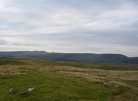
The hill takes the form of a plateau with sharp rims on several sides. To the northeast is Craig Pwllfa overlooking Cwm Banw whilst Craig y Fan looks east over Cwm
Tarthwynni. To the south is the edge known as Cwar y Gigfran which translates into English as 'quarry of the crow'. It marks the top of
372:
Several ridges extend north and east from the plateau. That known as Gist Wen runs north-northeast to the subsidiary top of Bryn (561m above sea level). The short ridges of Cefn Bach and Cefn Edmwnt run northeast whilst that of Twyn Du extends eastwards towards
272:
320:
294:
218:
444:
397:
Nuttall, John & Anne (1999). The
Mountains of England & Wales - Volume 1: Wales (2nd edition ed.). Milnthorpe, Cumbria: Cicerone.
244:
124:
402:
212:
350:
117:
449:
454:
439:
85:
75:
266:
44:
418:
361:. Its height is 769 m (2,523 ft) and it tops a large boggy plateau rising to the east of
374:
97:
381:(654m). To the south a broad ridge runs to a col beyond which is the top of Allt Forgan (513m).
459:
398:
231:
226:
334:
307:
281:
205:
198:
172:
110:
102:
52:
433:
330:
303:
106:
424:
139:
126:
378:
362:
314:
288:
90:
48:
36:
346:
40:
369:
a large landslip area extending to the stream of Blaen y Glyn below.
65:
30:
425:
www.geograph.co.uk : photos of Waun Rydd and surrounding area
358:
354:
191:
187:
377:. A further ridge runs southeast to the subsidiary top of
225:
211:
197:
183:
178:
168:
160:
155:
116:
96:
84:
74:
64:
59:
23:
8:
242:
20:
390:
7:
14:
16:Mountain (769.2m) in Powys, Wales
29:
1:
445:Mountains and hills of Powys
351:Brecon Beacons National Park
476:
326:654 metres (2,146 ft)
300:719 metres (2,359 ft)
278:754 metres (2,474 ft)
70:769 m (2,523 ft)
28:
80:170 m (560 ft)
421:at hill-bagging.co.uk
267:Gwaun Cerrig Llwydion
45:Gwaun Cerrig Llwydion
248:
161:English translation
136: /
375:Talybont Reservoir
243:
140:51.8766°N 3.3641°W
60:Highest point
450:Marilyns of Wales
340:
339:
241:
240:
467:
455:Hewitts of Wales
406:
395:
323:
297:
275:
249:
221:
201:
169:Language of name
151:
150:
148:
147:
146:
145:51.8766; -3.3641
141:
137:
134:
133:
132:
129:
47:, Waun Rydd and
33:
21:
475:
474:
470:
469:
468:
466:
465:
464:
430:
429:
415:
410:
409:
396:
392:
387:
319:
293:
271:
217:
199:
144:
142:
138:
135:
130:
127:
125:
123:
122:
55:
35:Left to right:
17:
12:
11:
5:
473:
471:
463:
462:
457:
452:
447:
442:
440:Brecon Beacons
432:
431:
428:
427:
422:
414:
413:External links
411:
408:
407:
389:
388:
386:
383:
353:, in southern
338:
337:
327:
324:
317:
311:
310:
301:
298:
291:
285:
284:
279:
276:
269:
263:
262:
259:
256:
253:
245:Listed summits
239:
238:
229:
223:
222:
215:
209:
208:
206:Brecon Beacons
203:
195:
194:
185:
181:
180:
176:
175:
170:
166:
165:
164:free/open moor
162:
158:
157:
153:
152:
120:
114:
113:
100:
94:
93:
88:
82:
81:
78:
72:
71:
68:
62:
61:
57:
56:
53:Cefn yr Ystrad
34:
26:
25:
15:
13:
10:
9:
6:
4:
3:
2:
472:
461:
458:
456:
453:
451:
448:
446:
443:
441:
438:
437:
435:
426:
423:
420:
417:
416:
412:
404:
403:1-85284-304-7
400:
394:
391:
384:
382:
380:
376:
370:
366:
364:
360:
356:
352:
348:
344:
336:
332:
328:
325:
322:
318:
316:
313:
312:
309:
305:
302:
299:
296:
292:
290:
287:
286:
283:
280:
277:
274:
270:
268:
265:
264:
260:
257:
254:
251:
250:
247:of Waun Rydd
246:
236:
233:
230:
228:
224:
220:
216:
214:
210:
207:
204:
202:
196:
193:
189:
186:
182:
177:
174:
171:
167:
163:
159:
154:
149:
121:
119:
115:
112:
108:
104:
101:
99:
95:
92:
89:
87:
83:
79:
77:
73:
69:
67:
63:
58:
54:
50:
46:
42:
38:
32:
27:
22:
19:
393:
371:
367:
342:
341:
234:
200:Parent range
18:
143: /
118:Coordinates
86:Parent peak
434:Categories
385:References
235:Landranger
128:51°52′36″N
76:Prominence
419:Waun Rydd
379:Allt Lwyd
363:Pen y Fan
343:Waun Rydd
315:Allt Lwyd
289:Fan y Big
179:Geography
131:3°21′51″W
91:Pen y Fan
66:Elevation
49:Allt Lwyd
37:Pen y Fan
24:Waun Rydd
460:Nuttalls
347:mountain
321:SJ066318
295:SJ066318
273:SJ066318
255:Grid ref
227:Topo map
219:SO012215
184:Location
349:in the
335:Nuttall
308:Nuttall
282:Nuttall
261:Status
213:OS grid
111:Nuttall
103:Marilyn
98:Listing
41:Corn Du
401:
331:Hewitt
304:Hewitt
258:Height
156:Naming
107:Hewitt
359:Wales
355:Powys
345:is a
192:Wales
188:Powys
173:Welsh
51:from
399:ISBN
329:sub
252:Name
39:and
237:160
436::
365:.
357:,
333:,
306:,
232:OS
190:,
109:,
105:,
43:,
405:.
Text is available under the Creative Commons Attribution-ShareAlike License. Additional terms may apply.