348:. The settlers disliked the name, which they interpreted to mean "stinking canoe", and began searching for a new name. The name was changed to Wellsford at a public meeting sometime between the late 1860s and early 1870s. The name was suggested by resident D.R. Lester, allegedly by creating an acronym from the surnames of settler families in the area. The earliest known references in print to Wellsford date to 1874. The modern site of Wellsford township was often referred to as the Gum Ridge in the 1870s.
357:
2098:
51:
507:
440:
2115:
2081:
656:. There were 654 households, comprising 984 males and 948 females, giving a sex ratio of 1.04 males per female. The median age was 34.4 years (compared with 37.4 years nationally), with 447 people (23.2%) aged under 15 years, 384 (19.9%) aged 15 to 29, 777 (40.3%) aged 30 to 64, and 327 (17.0%) aged 65 or older.
681:
Rodney
College is a secondary (years 9–13) school with a roll of 325 students. Wellsford School is a full primary (years 1–8) school with a roll of 363 students. Rodney College's Board of Trustees was dismissed in August 2008 and a Ministry of Education commissioner appointed. By 2016, the college
672:
Of those at least 15 years old, 135 (9.1%) people had a bachelor's or higher degree, and 381 (25.7%) people had no formal qualifications. The median income was $ 25,400, compared with $ 31,800 nationally. 138 people (9.3%) earned over $ 70,000 compared to 17.2% nationally. The employment status of
493:
diggers' camps were established across the area in the 1870s, including a 500 acres (200 ha) area called the Wayby Kauri Gum
Reserve that was set aside for the practice. The modern Wellsford township site was also dug for kauri gum, and was often referred to as The Gum Ridge. Members of Te
523:
was extended north to
Wellsford. This led to economic development in Wellsford, especially dairy farming and sheep farming operations. During this period, the town gradually moved away from the shores of the Whakapirau Stream, with the new centre of Wellsford developing near the train station.
423:
in the area through the union between
Haumoewhārangi's granddaughter Moerangaranga and Maki's son Ngāwhetu, and Ngāti Manuhiri developed ties with Te Uri-o-Hau. Te Uri-o-Hau, including the hapū Ngāti Mauku and Ngāti Tahuhu, lived seasonally along the Oruawharo River.
580:
Wellsford is described by
Statistics New Zealand as a small urban area. It covers 4.72 km (1.82 sq mi) and had an estimated population of 2,280 as of June 2023, with a population density of 483 people per km.
1561:
1828:
906:
497:
In 1885, the Crown purchased the Pakiri Block from Ngāti
Manuhiri, an area that included the areas immediately adjacent to Wellsford. This led to the expansion of Wellsford to the south, away from the Whakapirau Stream.
535:. Passenger train services to Wellsford ceased in 1975. In 1979, Irwin Industrial Tools was established in Wellsford, constructing circular saw-blades and growing to be a major local employer, before closing in 2009.
688:
Wellsford, Tauhoa, Pākiri, Tāpora, Tomarata and
Mangawhai Primary Schools all cater for students from year 1–8, and collectively contribute to the annual in take of roughly 80 year 9 students at Rodney College.
494:
Uri-o-Hau traded and intermingled with the
Alberton settlers. The settlement's modern name, Wellsford, was likely adopted in the early 1870s. Wellsford would move eastwards over time to its current location.
518:
By 1900, the timber and kauri gum trades had begun to recede, and settlers turned to dairy farming as a primarily source of income. The Wayby Co-operative Dairy
Company established in 1902. In 1909, the
1237:
527:
Dairy farming in the region intensified further with the establishment of better roads in the 1930s. As roads improved, the town developed as a service stop for people travelling between
Auckland and
486:
looking for a new world". Wellsford was originally known by the name Whakapirau, and settlers established a settlement between the Whakapirau Stream and the eastern borders of the Oruawharo Block.
1821:
1814:
368:
on the west coast extending inland for 20 kilometres (12 mi) from the body of the harbour, stretching to within 15 kilometres (9.3 mi) of the east (Pacific Ocean) coast.
760:. In 1953 the town committee for Wellsford was formed. This became the Wellsford County Borough Council in 1971 and in 1974 it became the Wellsford District Community Council.
431:, the eastern Kaipara was depopulated, as people sought refuge in other parts of the country. Te Uri-o-Hau and Ngāti Rango gradually returned to the area by the late 1830s.
2155:
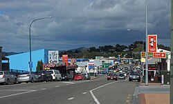
644:
Before the 2023 census, the town had a smaller boundary, covering 4.55 km (1.76 sq mi). Using that boundary, Wellsford had a population of 1,929 at the
659:
Ethnicities were 79.5% European/Pākehā, 24.4% Māori, 5.3% Pacific peoples, 6.1% Asian, and 1.7% other ethnicities. People may identify with more than one ethnicity.
489:
Initial industry at Whakapirau was dominated by the timber trade, and in 1864 Nicholson's timber mill was established on the southern banks of the Oruawharo River.
2150:
2140:
1039:
2007:
1392:
1178:
665:
Although some people chose not to answer the census's question about religious affiliation, 50.4% had no religion, 36.5% were Christian, 3.0% had
572:
to Wellsford in the future, and housing developments in the 2020s have been predicted to increase the size of the town by more than 800 houses.
1593:
1106:
2069:
305:
including Ngāti Mauku, Ngāti Tahuhu and Ngāti Rongo being established from the descendants of Haumoewhārangi, and by strategic marriages with
1329:
68:
379:. The upper reaches of the Whakapirau Creek are located to the north of the town, while southern Wellsford is in the catchment of the
394:
The highest point in the town is a 135 metres (443 ft) hill located east of the junction of Matheson Road and Worthington Road.
1731:
1305:
1201:
1013:
1534:
812:
673:
those at least 15 was that 681 (46.0%) people were employed full-time, 213 (14.4%) were part-time, and 66 (4.5%) were unemployed.
2145:
458:
Under a Special Settlement Scheme by the Government, the Oruawharo Block became a planned settlement, predominantly settled by
376:
110:
1415:
532:
372:
1961:
1266:
983:
951:
344:
The settlement was originally known by its Māori name Whakapirau, which is the name of the local creek flowing into the
267:
1674:
263:
2002:
1144:
1688:
757:
565:
558:
50:
724:
being amongst the more popular sports played. The Wellsford Golf Club is popular among the locals and also houses
1838:
779:
415:
migrated south to the Kaipara Harbour. The northern and eastern Kaipara, including Wellsford, were controlled by
1870:
753:
471:
220:
100:
2017:
1496:
1620:
1358:
2051:
2012:
876:
858:
840:
653:
649:
645:
1609:
1420:
1336:
1325:
1271:
1244:
1233:
1069:
880:
862:
844:
569:
452:
1806:
1598:
877:"Subnational population estimates (urban rural), by age and sex, at 30 June 1996-2023 (2023 boundaries)"
336:
farming, in part due to the opening of Wellsford railway station in 1909, linking the town to Auckland.
306:
156:
1660:
859:"Subnational population estimates (TA, SA2), by age and sex, at 30 June 1996-2023 (2023 boundaries)"
841:"Subnational population estimates (RC, SA2), by age and sex, at 30 June 1996-2023 (2023 boundaries)"
520:
511:
247:
564:
By the 21st century, tourism and lifestyle blocks has increasingly drawn people to Wellsford. The
2087:
2038:
1632:
902:
783:
721:
135:
1951:
1064:
543:
408:
294:
1519:
1926:
1770:
1727:
1539:
1450:
1321:
1301:
1009:
666:
356:
289:
since the 13th or 14th centuries, who utilised the inland forests and marine resources of the
237:
40:
2033:
1931:
1760:
1568:
1202:
Cultural Values Assessment for the Warkworth North Structure Plan and Associated Development
1151:
1113:
913:
775:
412:
271:
179:
1986:
1941:
771:
764:
483:
448:
388:
384:
365:
345:
325:
290:
282:
255:
115:
1946:
554:
286:
1936:
1921:
725:
550:
479:
380:
161:
669:, 1.1% were Hindu, 0.2% were Muslim, 0.8% were Buddhist and 1.4% had other religions.
17:
2134:
1981:
1976:
1966:
741:
729:
475:
364:
Wellsford is close to a narrowing of the Northland Peninsula caused by an arm of the
313:
1971:
1956:
1637:
1229:
539:
419:, a Ngāti Whātua tribal grouping led by Haumoewhārangi. Ngāti Rongo developed as a
416:
298:
259:
251:
1387:
528:
275:
1726:. Auckland University Press, Oxford University Press. pp. 49, 57, 116, 128.
1073:. Vol. XII, no. 3862. 30 March 1874. p. 2 – via Papers Past.
662:
The percentage of people born overseas was 17.3, compared with 27.1% nationally.
2043:
1916:
1860:
1846:
787:
701:
506:
428:
125:
1173:
700:
Being a rural town, sport plays a big part in Wellsford's day-to-day life with
1885:
1145:
Warkworth to Wellsford Urban & Landscape Design Framework Planning Version
463:
439:
321:
2104:
1774:
975:
943:
83:
70:
685:
Living Way Christian School closed at the end of 2018 due to falling rolls.
490:
329:
1875:
1865:
1765:
1748:
1724:
The Evolution of Local Government Areas in Metropolitan Auckland, 1840–1971
467:
332:. By the early 20th century, the area developed into a regional centre for
1895:
1842:
1890:
1504:
1006:
Rodney Coast to Coast: the Story of the Rodney County Council 1976-1989
737:
733:
713:
709:
598:
546:
459:
420:
317:
302:
2121:
1238:
Deed of Settlement to Settle Te Uri o Hau Historical Claims: Schedules
1880:
1749:"The planning framework for Auckland 'super city': an insider's view"
1105:
Phear, Sarah; Farley, Glen; Burnett, Zarah; Clough, Rod (July 2019).
717:
705:
1796:
1709:
505:
438:
355:
333:
262:. It is a major regional centre, being located at the junction of
1482:
692:
All the schools are coeducational. Rolls are as of August 2024.
1810:
254:
of New Zealand. It is the northernmost major settlement in the
1791:
538:
The local Ōruawharo Marae is a traditional meeting ground for
2063:
1359:"Names & Opening & Closing Dates of Railway Stations"
790:
councillor, who represents the area on the Auckland Council.
1464:
1040:
Hoteo River Catchment: Environment and Socio-economic Review
593:
1801:
455:
in 1860, followed by the Hoteo Block to the south in 1868.
1442:
1596:. Statistics New Zealand. March 2020. Wellsford (110500).
835:
833:
557:. It includes the Rangimārie meeting house. In 1990, the
770:
In November 2010, all city and district councils in the
371:
The town is located on hilltops at the junction between
1535:"Pūhoi to Warkworth motorway opening pushed back again"
258:, and is 77 kilometres (48 mi) northwest of the
514:
in 2018 with logs waiting to be loaded onto a train.
474:
and Wellsford. These settlers called themselves the
2026:
1995:
1909:
1853:
1388:"Auckland places - Kaipara Harbour and kauri towns"
1107:
Warkworth to Wellsford Historic Heritage Assessment
756:in 1876, Wellsford became part of the newly formed
740:, (indoors and outdoors) are also available, while
219:
211:
203:
198:
190:
185:
175:
170:
149:
141:
131:
121:
109:
99:
34:
1138:
1136:
1134:
1132:
1130:
782:. Electors in Wellsford vote for the seven-member
652:, and an increase of 258 people (15.4%) since the
482:'s consort. They were a "breakaway group from the
502:Establishment of the railway, modern development
1100:
1792:Official Wellsford and areas community website
1588:
1586:
1098:
1096:
1094:
1092:
1090:
1088:
1086:
1084:
1082:
1080:
1038:Hart, Georgina; Scott, Kathryn (August 2014).
648:, an increase of 216 people (12.6%) since the
1822:
1234:Her Majesty the Queen in Right of New Zealand
1207:(Report). Manuhiri Kaitiaki Chariatable Trust
774:were merged into a single unitary authority,
383:. The Whakapirau Creek is a tributary of the
8:
1594:"Statistical area 1 dataset for 2018 Census"
584:
1174:"Ngāti Whātua - The tribes of Ngāti Whātua"
1008:. Times Media Group Ltd. pp. 156–162.
466:area, who settled between 1862 and 1865 at
1829:
1815:
1807:
1562:Auckland Future Urban Land Supply Strategy
1224:
1222:
583:
270:, almost halfway between Auckland and the
31:
1764:
1675:"Falling roll forces Living Way to close"
1330:"Deed of Settlement of Historical Claims"
763:From 1989 to 2010, Wellsford was part of
2008:Cape Rodney-Okakari Point Marine Reserve
1663:. Education Review Office. 16 June 2016.
1393:Te Ara - the Encyclopedia of New Zealand
1291:
1289:
1179:Te Ara - the Encyclopedia of New Zealand
2156:Populated places in the Auckland Region
2076:
1033:
1031:
1029:
1027:
1025:
970:
968:
799:
218:
197:
184:
169:
148:
98:
63:
59:
47:
938:
936:
934:
932:
930:
807:
805:
803:
1386:McClure, Margaret (6 December 2007).
976:"Place name detail: Whakapirau Creek"
210:
202:
189:
174:
140:
130:
120:
108:
7:
2151:Populated places established in 1862
1599:2018 Census place summary: Wellsford
1267:"How not to rob a bank, paragraph 5"
907:Wellsford Centennial Park Masterplan
1691:. New Zealand Ministry of Education
194:4.72 km (1.82 sq mi)
2141:1862 establishments in New Zealand
1621:Education Counts: Wellsford School
1366:Rail Heritage Trust of New Zealand
462:tradespeople and farmers from the
320:tradespeople and farmers from the
226:0900, 0977, 0975, 0972, 0974, 0973
176: • Territorial Authority
25:
2052:Rodney District Council (defunct)
1633:"Commissioner for Rodney College"
1414:Slade, Maria (17 November 2009).
510:Wellsford railway station on the
312:Wellsford was established by the
2113:
2096:
2079:
1677:. Localmatters. 15 October 2018.
1610:Education Counts: Rodney College
1520:"History – A museum takes shape"
1265:Taylor, Phil (14 October 2006).
1172:Taonui, Rāwiri (22 March 2017).
360:View of rural Wellsford farmland
49:
1689:"New Zealand Schools Directory"
1533:Pennington, Phil (6 May 2022).
568:is planned to be extended from
443:View of rural Wellsford in 1914
328:, developing into a timber and
944:"Place name detail: Wellsford"
324:area who settled the southern
301:by the mid-17th century, with
293:. The area became home to the
29:Place in Auckland, New Zealand
1:
1661:"Rodney College - 16/06/2016"
1518:Johnston, Lyn (12 May 2021).
1485:. Albertland Heritage Museum.
744:is also popular in the area.
407:During the mid-18th century,
1497:"Albertland Heritage Museum"
1483:"Albertland Heritage Museum"
1200:McKenzie, Fiona (May 2017).
984:New Zealand Geographic Board
952:New Zealand Geographic Board
1471:. Te Potiki National Trust.
1443:"Te Kāhui Māngai directory"
1416:"Closure hits founder hard"
1143:Boffa Miskell (June 2019).
1045:(Report). Landcare Research
874:(territorial authorities);
2172:
1996:Facilities and attractions
1712:. Retrieved 16 March 2013.
752:With the abolition of the
566:Auckland Northern Motorway
559:Albertland Heritage Museum
1802:Albertland Museum website
1722:Bloomfield, G.T. (1973).
637:
611:—
215:480/km (1,300/sq mi)
64:
60:
48:
2003:Ātiu Creek Regional Park
1837:Wellsford Subdivision -
1747:Blakeley, Roger (2015).
1296:Bioletti, Harry (1992).
1004:Bioletti, Harry (1992).
813:"ArcGIS Web Application"
778:, with Warkworth in the
754:provinces of New Zealand
427:In the 1820s during the
55:Main Street in Wellsford
2146:Rodney Local Board Area
1797:Visit Wellsford website
1710:Sports groups and clubs
1357:Scoble, Juliet (2010).
817:statsnz.maps.arcgis.com
780:Rodney Local Board area
667:Māori religious beliefs
646:2018 New Zealand census
478:, after Prince Albert,
1766:10.26686/pq.v11i4.4572
1421:The New Zealand Herald
1337:New Zealand Government
1272:The New Zealand Herald
1245:New Zealand Government
1070:The New Zealand Herald
881:Statistics New Zealand
863:Statistics New Zealand
845:Statistics New Zealand
515:
444:
361:
241:
84:36.29583°S 174.52333°E
18:Wellsford, New Zealand
2068:at Knowledge (XXG)'s
2018:Te Ārai Regional Park
1298:Rodney Coast to Coast
980:New Zealand Gazetteer
948:New Zealand Gazetteer
856:(regional councils);
682:was performing well.
585:Historical population
561:opened in Wellsford.
509:
442:
359:
145:Wellsford subdivision
2013:Pākiri Regional Park
1236:(13 December 2000).
316:in 1862, a group of
285:has been settled by
212: • Density
157:Kaipara ki Mahurangi
89:-36.29583; 174.52333
1910:Geographic features
1641:. 23 September 2008
1300:. p. 156-166.
586:
521:North Auckland Line
512:North Auckland Line
248:Northland Peninsula
246:) is a town on the
80: /
2039:Rodney Local Board
903:Rodney Local Board
784:Rodney Local Board
516:
451:were purchased by
445:
435:Early colonial era
362:
204: • Total
191: • Total
136:Rodney Local Board
2061:
2060:
1927:Kaiwakawaka River
1540:Radio New Zealand
642:
641:
447:The banks of the
231:
230:
16:(Redirected from
2163:
2126:
2118:
2117:
2116:
2109:
2101:
2100:
2099:
2092:
2084:
2083:
2082:
2072:
2034:Auckland Council
1932:Manukapua Island
1854:Populated places
1831:
1824:
1817:
1808:
1779:
1778:
1768:
1753:Policy Quarterly
1744:
1738:
1737:
1719:
1713:
1707:
1701:
1700:
1698:
1696:
1685:
1679:
1678:
1671:
1665:
1664:
1657:
1651:
1650:
1648:
1646:
1629:
1623:
1618:
1612:
1607:
1601:
1597:
1590:
1581:
1580:
1578:
1576:
1569:Auckland Council
1566:
1558:
1552:
1551:
1549:
1547:
1530:
1524:
1523:
1522:. Local Matters.
1515:
1509:
1508:
1493:
1487:
1486:
1479:
1473:
1472:
1461:
1455:
1454:
1439:
1433:
1432:
1430:
1428:
1411:
1405:
1404:
1402:
1400:
1383:
1377:
1376:
1374:
1372:
1363:
1354:
1348:
1347:
1345:
1343:
1334:
1318:
1312:
1311:
1293:
1284:
1283:
1281:
1279:
1262:
1256:
1255:
1253:
1251:
1242:
1226:
1217:
1216:
1214:
1212:
1206:
1197:
1191:
1190:
1188:
1186:
1169:
1163:
1162:
1160:
1158:
1152:Auckland Council
1149:
1140:
1125:
1124:
1122:
1120:
1114:Auckland Council
1111:
1102:
1075:
1074:
1061:
1055:
1054:
1052:
1050:
1044:
1035:
1020:
1019:
1001:
995:
994:
992:
990:
972:
963:
962:
960:
958:
940:
925:
924:
922:
920:
914:Auckland Council
911:
899:
893:
891:
889:
887:
873:
871:
869:
855:
853:
851:
837:
828:
827:
825:
823:
809:
776:Auckland Council
748:Local government
600:
595:
587:
387:, an arm of the
377:State Highway 16
264:State Highways 1
250:in the northern
180:Auckland Council
95:
94:
92:
91:
90:
85:
81:
78:
77:
76:
73:
53:
32:
21:
2171:
2170:
2166:
2165:
2164:
2162:
2161:
2160:
2131:
2130:
2129:
2119:
2114:
2112:
2108:from Wikivoyage
2102:
2097:
2095:
2085:
2080:
2078:
2075:
2071:sister projects
2070:
2062:
2057:
2022:
1991:
1987:Wharehine River
1952:Pāpakanui River
1942:Oruawharo River
1905:
1849:
1835:
1788:
1783:
1782:
1746:
1745:
1741:
1734:
1721:
1720:
1716:
1708:
1704:
1694:
1692:
1687:
1686:
1682:
1673:
1672:
1668:
1659:
1658:
1654:
1644:
1642:
1631:
1630:
1626:
1619:
1615:
1608:
1604:
1592:
1591:
1584:
1574:
1572:
1564:
1560:
1559:
1555:
1545:
1543:
1532:
1531:
1527:
1517:
1516:
1512:
1501:nzmuseums.co.nz
1495:
1494:
1490:
1481:
1480:
1476:
1463:
1462:
1458:
1441:
1440:
1436:
1426:
1424:
1413:
1412:
1408:
1398:
1396:
1385:
1384:
1380:
1370:
1368:
1361:
1356:
1355:
1351:
1341:
1339:
1332:
1328:(21 May 2011).
1320:
1319:
1315:
1308:
1295:
1294:
1287:
1277:
1275:
1264:
1263:
1259:
1249:
1247:
1240:
1228:
1227:
1220:
1210:
1208:
1204:
1199:
1198:
1194:
1184:
1182:
1171:
1170:
1166:
1156:
1154:
1147:
1142:
1141:
1128:
1118:
1116:
1109:
1104:
1103:
1078:
1063:
1062:
1058:
1048:
1046:
1042:
1037:
1036:
1023:
1016:
1003:
1002:
998:
988:
986:
974:
973:
966:
956:
954:
942:
941:
928:
918:
916:
909:
901:
900:
896:
885:
883:
875:
867:
865:
857:
849:
847:
839:
838:
831:
821:
819:
811:
810:
801:
796:
772:Auckland Region
765:Rodney District
750:
698:
679:
578:
533:State Highway 1
504:
484:Anglican Church
449:Oruawharo River
437:
405:
400:
389:Kaipara Harbour
385:Oruawharo River
373:State Highway 1
366:Kaipara Harbour
354:
346:Kaipara Harbour
342:
326:Oruawharo River
291:Kaipara Harbour
283:Kaipara Harbour
256:Auckland Region
227:
166:
132:Community board
88:
86:
82:
79:
74:
71:
69:
67:
66:
56:
44:
37:
30:
23:
22:
15:
12:
11:
5:
2169:
2167:
2159:
2158:
2153:
2148:
2143:
2133:
2132:
2128:
2127:
2110:
2093:
2064:
2059:
2058:
2056:
2055:
2048:
2047:
2046:
2041:
2030:
2028:
2024:
2023:
2021:
2020:
2015:
2010:
2005:
1999:
1997:
1993:
1992:
1990:
1989:
1984:
1979:
1974:
1969:
1964:
1962:Spectacle Lake
1959:
1954:
1949:
1944:
1939:
1934:
1929:
1924:
1919:
1913:
1911:
1907:
1906:
1904:
1903:
1898:
1893:
1888:
1883:
1878:
1873:
1868:
1863:
1857:
1855:
1851:
1850:
1836:
1834:
1833:
1826:
1819:
1811:
1805:
1804:
1799:
1794:
1787:
1786:External links
1784:
1781:
1780:
1739:
1732:
1714:
1702:
1680:
1666:
1652:
1624:
1613:
1602:
1582:
1553:
1525:
1510:
1488:
1474:
1456:
1451:Te Puni Kōkiri
1434:
1406:
1378:
1349:
1322:Ngāti Manuhiri
1313:
1306:
1285:
1257:
1218:
1192:
1164:
1126:
1076:
1056:
1021:
1014:
996:
964:
926:
894:
829:
798:
797:
795:
792:
749:
746:
697:
694:
678:
675:
640:
639:
635:
634:
631:
628:
624:
623:
620:
617:
613:
612:
609:
606:
602:
601:
596:
591:
577:
574:
503:
500:
480:Queen Victoria
436:
433:
404:
401:
399:
396:
353:
350:
341:
338:
229:
228:
225:
223:
217:
216:
213:
209:
208:
205:
201:
200:
196:
195:
192:
188:
187:
183:
182:
177:
173:
172:
168:
167:
165:
164:
162:Te Tai Tokerau
159:
153:
151:
147:
146:
143:
139:
138:
133:
129:
128:
123:
119:
118:
113:
107:
106:
103:
97:
96:
62:
61:
58:
57:
54:
46:
45:
38:
35:
28:
24:
14:
13:
10:
9:
6:
4:
3:
2:
2168:
2157:
2154:
2152:
2149:
2147:
2144:
2142:
2139:
2138:
2136:
2125:from Wikidata
2124:
2123:
2111:
2107:
2106:
2105:Travel guides
2094:
2090:
2089:
2077:
2073:
2067:
2054:
2053:
2049:
2045:
2042:
2040:
2037:
2036:
2035:
2032:
2031:
2029:
2025:
2019:
2016:
2014:
2011:
2009:
2006:
2004:
2001:
2000:
1998:
1994:
1988:
1985:
1983:
1982:Whanaki River
1980:
1978:
1977:Waireia River
1975:
1973:
1970:
1968:
1967:Tomarata Lake
1965:
1963:
1960:
1958:
1955:
1953:
1950:
1948:
1945:
1943:
1940:
1938:
1935:
1933:
1930:
1928:
1925:
1923:
1920:
1918:
1915:
1914:
1912:
1908:
1902:
1899:
1897:
1894:
1892:
1889:
1887:
1884:
1882:
1879:
1877:
1874:
1872:
1869:
1867:
1864:
1862:
1859:
1858:
1856:
1852:
1848:
1844:
1840:
1832:
1827:
1825:
1820:
1818:
1813:
1812:
1809:
1803:
1800:
1798:
1795:
1793:
1790:
1789:
1785:
1776:
1772:
1767:
1762:
1758:
1754:
1750:
1743:
1740:
1735:
1733:0 19 647714 X
1729:
1725:
1718:
1715:
1711:
1706:
1703:
1690:
1684:
1681:
1676:
1670:
1667:
1662:
1656:
1653:
1640:
1639:
1634:
1628:
1625:
1622:
1617:
1614:
1611:
1606:
1603:
1600:
1595:
1589:
1587:
1583:
1570:
1563:
1557:
1554:
1542:
1541:
1536:
1529:
1526:
1521:
1514:
1511:
1506:
1502:
1498:
1492:
1489:
1484:
1478:
1475:
1470:
1469:maorimaps.com
1466:
1460:
1457:
1452:
1448:
1444:
1438:
1435:
1423:
1422:
1417:
1410:
1407:
1395:
1394:
1389:
1382:
1379:
1367:
1360:
1353:
1350:
1338:
1331:
1327:
1323:
1317:
1314:
1309:
1307:0-473-01296-0
1303:
1299:
1292:
1290:
1286:
1274:
1273:
1268:
1261:
1258:
1246:
1239:
1235:
1231:
1225:
1223:
1219:
1203:
1196:
1193:
1181:
1180:
1175:
1168:
1165:
1153:
1146:
1139:
1137:
1135:
1133:
1131:
1127:
1115:
1108:
1101:
1099:
1097:
1095:
1093:
1091:
1089:
1087:
1085:
1083:
1081:
1077:
1072:
1071:
1066:
1060:
1057:
1041:
1034:
1032:
1030:
1028:
1026:
1022:
1017:
1015:0-473-01296-0
1011:
1007:
1000:
997:
985:
981:
977:
971:
969:
965:
953:
949:
945:
939:
937:
935:
933:
931:
927:
915:
908:
904:
898:
895:
892:(urban areas)
882:
878:
864:
860:
846:
842:
836:
834:
830:
818:
814:
808:
806:
804:
800:
793:
791:
789:
786:, and also a
785:
781:
777:
773:
768:
766:
761:
759:
758:Rodney County
755:
747:
745:
743:
739:
735:
731:
730:Rollerskating
727:
723:
719:
715:
711:
707:
703:
695:
693:
690:
686:
683:
676:
674:
670:
668:
663:
660:
657:
655:
651:
647:
636:
632:
629:
626:
625:
621:
618:
615:
614:
610:
607:
604:
603:
597:
592:
589:
588:
582:
575:
573:
571:
567:
562:
560:
556:
552:
548:
545:
541:
536:
534:
530:
525:
522:
513:
508:
501:
499:
495:
492:
487:
485:
481:
477:
476:Albertlanders
473:
469:
465:
461:
456:
454:
450:
441:
434:
432:
430:
425:
422:
418:
414:
410:
403:Māori history
402:
397:
395:
392:
390:
386:
382:
378:
374:
369:
367:
358:
351:
349:
347:
339:
337:
335:
331:
327:
323:
319:
315:
314:Albertlanders
310:
308:
304:
300:
296:
292:
288:
284:
279:
277:
273:
269:
265:
261:
257:
253:
249:
245:
244:
239:
235:
224:
222:
214:
206:
193:
181:
178:
163:
160:
158:
155:
154:
152:
144:
137:
134:
127:
124:
117:
114:
112:
104:
102:
93:
65:Coordinates:
52:
42:
33:
27:
19:
2120:
2103:
2091:from Commons
2086:
2065:
2050:
1972:Topuni River
1957:Slipper Lake
1947:Pākiri River
1900:
1756:
1752:
1742:
1723:
1717:
1705:
1695:17 September
1693:. Retrieved
1683:
1669:
1655:
1643:. Retrieved
1638:Rodney Times
1636:
1627:
1616:
1605:
1573:. Retrieved
1556:
1544:. Retrieved
1538:
1528:
1513:
1500:
1491:
1477:
1468:
1465:"Māori Maps"
1459:
1446:
1437:
1425:. Retrieved
1419:
1409:
1397:. Retrieved
1391:
1381:
1369:. Retrieved
1365:
1352:
1340:. Retrieved
1316:
1297:
1276:. Retrieved
1270:
1260:
1248:. Retrieved
1230:Te Uri o Hau
1209:. Retrieved
1195:
1183:. Retrieved
1177:
1167:
1155:. Retrieved
1117:. Retrieved
1068:
1059:
1047:. Retrieved
1005:
999:
987:. Retrieved
979:
955:. Retrieved
947:
917:. Retrieved
905:(May 2023).
897:
884:. Retrieved
866:. Retrieved
848:. Retrieved
820:. Retrieved
816:
769:
762:
751:
699:
691:
687:
684:
680:
671:
664:
661:
658:
643:
579:
576:Demographics
563:
555:Ngāti Tahuhu
544:Ngāti Whātua
540:Te Uri-o-Hau
537:
526:
517:
496:
488:
457:
446:
426:
417:Te Uri-o-Hau
409:Ngāti Whātua
406:
393:
370:
363:
343:
311:
299:Te Uri-o-Hau
295:Ngāti Whātua
281:The eastern
280:
260:Auckland CBD
252:North Island
242:
233:
232:
39:Whakapirau (
26:
2044:Rodney ward
1937:Ōpatu River
1922:Hōteo River
1917:Dome Forest
1871:Port Albert
1861:Dome Valley
1847:New Zealand
1571:. July 2017
1447:tkm.govt.nz
788:Rodney ward
654:2006 census
650:2013 census
551:Ngāti Mauku
472:Port Albert
429:Musket Wars
411:peoples of
381:Hōteo River
297:collective
221:Postcode(s)
150:Electorates
142:Subdivision
126:Rodney ward
105:New Zealand
87: /
75:174°31′24″E
2135:Categories
2027:Government
1645:2 December
1575:16 January
1567:(Report).
1546:16 January
1427:16 January
1399:16 January
1371:16 January
1250:16 January
1243:(Report).
1211:15 January
1185:16 January
1157:16 January
1150:(Report).
1119:16 January
1112:(Report).
1065:"Untitled"
1049:16 January
989:15 January
957:15 January
919:16 January
912:(Report).
886:25 October
868:25 October
850:25 October
794:References
742:equestrian
464:Birmingham
322:Birmingham
307:Te Kawerau
243:Whakapirau
199:Population
171:Government
72:36°17′45″S
2066:Wellsford
1901:Wellsford
1775:2324-1101
1326:The Crown
722:athletics
677:Education
570:Warkworth
529:Whangārei
491:Kauri gum
453:the Crown
413:Northland
352:Geography
340:Etymology
330:kauri gum
276:Whangārei
272:Northland
234:Wellsford
36:Wellsford
1896:Tomarata
1843:Auckland
1278:19 March
822:27 April
728:courts.
638:Source:
542:and the
274:city of
116:Auckland
1891:Te Hana
1886:Te Ārai
1505:Te Papa
738:bowling
734:archery
714:cricket
710:netball
599:±% p.a.
460:Baptist
398:History
318:Baptist
101:Country
1881:Tauhoa
1876:Tāpora
1866:Pākiri
1839:Rodney
1773:
1730:
1342:18 May
1304:
1012:
726:squash
718:tennis
706:soccer
633:+2.40%
622:+0.36%
531:along
468:Tāpora
309:hapū.
111:Region
2088:Media
1759:(4).
1565:(PDF)
1362:(PDF)
1333:(PDF)
1241:(PDF)
1205:(PDF)
1148:(PDF)
1110:(PDF)
1043:(PDF)
910:(PDF)
702:rugby
696:Sport
630:1,929
619:1,713
608:1,671
334:dairy
287:Māori
238:Māori
207:2,280
41:Māori
2122:Data
1771:ISSN
1728:ISBN
1697:2024
1647:2011
1577:2024
1548:2024
1429:2024
1401:2024
1373:2024
1344:2022
1302:ISBN
1280:2008
1252:2024
1213:2024
1187:2024
1159:2024
1121:2024
1051:2024
1010:ISBN
991:2024
959:2024
921:2024
888:2023
870:2023
852:2023
824:2024
736:and
720:and
627:2018
616:2013
605:2006
594:Pop.
590:Year
553:and
547:hapū
421:hapū
375:and
303:hapū
266:and
186:Area
122:Ward
1761:doi
549:of
2137::
1845:,
1841:,
1769:.
1757:11
1755:.
1751:.
1635:.
1585:^
1537:.
1503:.
1499:.
1467:.
1449:.
1445:.
1418:.
1390:.
1364:.
1335:.
1324:;
1288:^
1269:.
1232:;
1221:^
1176:.
1129:^
1079:^
1067:.
1024:^
982:.
978:.
967:^
950:.
946:.
929:^
879:.
861:.
843:.
832:^
815:.
802:^
767:.
732:,
716:,
712:,
708:,
704:,
470:,
391:.
278:.
268:16
240::
2074::
1830:e
1823:t
1816:v
1777:.
1763::
1736:.
1699:.
1649:.
1579:.
1550:.
1507:.
1453:.
1431:.
1403:.
1375:.
1346:.
1310:.
1282:.
1254:.
1215:.
1189:.
1161:.
1123:.
1053:.
1018:.
993:.
961:.
923:.
890:.
872:.
854:.
826:.
236:(
43:)
20:)
Text is available under the Creative Commons Attribution-ShareAlike License. Additional terms may apply.