794:
371:
45:
516:. There were 675 households, comprising 1,017 males and 1,068 females, giving a sex ratio of 0.95 males per female. The median age was 39.7 years (compared with 37.4 years nationally), with 549 people (26.3%) aged under 15 years, 207 (9.9%) aged 15 to 29, 1,116 (53.5%) aged 30 to 64, and 210 (10.1%) aged 65 or older.
560:
Of those at least 15 years old, 444 (28.9%) people had a bachelor's or higher degree, and 153 (10.0%) people had no formal qualifications. The median income was $ 55,400, compared with $ 31,800 nationally. 573 people (37.3%) earned over $ 70,000 compared to 17.2% nationally. The employment status of
413:
One more subdivision and a southern extension of
Wilfield are planned to be built. This third subdivision is being developed by Hughes Developments Ltd, and will be built to the east of Gainsborough. A retirement village, developed by Marama Te Wai Ltd, is to be built to the west of Preston Downs.
709:
Of those at least 15 years old, 873 (21.2%) people had a bachelor's or higher degree, and 663 (16.1%) people had no formal qualifications. 1,035 people (25.2%) earned over $ 70,000 compared to 17.2% nationally. The employment status of those at least 15 was that 2,271 (55.3%) people were employed
409:
In 2007, West Melton saw the start of its urban expansion. Gainsborough and
Halkett Grove subdivisions were the first developments to be built, followed by Preston Downs to the west of Gainsborough and a third subdivision called Wilfield built to the south of Gainsborough.
1055:
665:. There were 1,698 households, comprising 2,622 males and 2,376 females, giving a sex ratio of 1.1 males per female, with 888 people (17.8%) aged under 15 years, 774 (15.5%) aged 15 to 29, 2,643 (52.9%) aged 30 to 64, and 693 (13.9%) aged 65 or older.
417:
The spread of housing developments into fertile rural land has led to tensions between the traditional farming community and recent arrivals. It is common for these tensions to spill onto community notice boards.
653:
Before the 2023 census, Newtons Road had a smaller boundary, covering 153.14 km (59.13 sq mi). Using that boundary, Halkett and
Newtons Road together had a population of 4,998 at the
414:
This is in contrast to scaled-down plans. In
December 2020, original plans were for a 50-hectare subdivision to be built, however, in June 2022, only 12.5 hectares was allocated for zoning change.
430:
as a small urban area, and covers 2.99 km (1.15 sq mi). It had an estimated population of 2,450 as of June 2023, with a population density of 819 people per km.
2089:
504:
Before the 2023 census, West Melton had a larger boundary, covering 5.32 km (2.05 sq mi). Using that boundary, West Melton had a population of 2,085 at the
894:
venue approximately 5 kilometres north of the town. It is located on
Weedons Ross Road, adjacent to West Melton airfield. The track is a significant venue for important
823:
A skate park and playground were built next to the community centre. The skate park finished completion in 2022, while the playground was completed in 2023
1408:
62:
2018:
2013:
1103:
1083:
351:
116:
2008:
590:. It covers 153.83 km (59.13 sq mi). It had an estimated population of 3,870 as of June 2023, with a population density of 25 people per km.
576:. It covers 86.01 km (33.21 sq mi). It had an estimated population of 1,740 as of June 2023, with a population density of 20 people per km.
831:
West Melton School is a full primary school catering for years 1 to 8. It had a roll of 465 as of August 2024. The school opened in 1871.
1918:
926:
561:
those at least 15 was that 918 (59.8%) people were employed full-time, 246 (16.0%) were part-time, and 27 (1.8%) were unemployed.
2003:
1970:
1750:
845:
1898:
208:
150:
1298:
690:
Although some people chose not to answer the census's question about religious affiliation, 53.0% had no religion, 38.8% were
541:
Although some people chose not to answer the census's question about religious affiliation, 51.9% had no religion, 40.1% were
2059:
2054:
2049:
869:
865:
2044:
1893:
1836:
1401:
983:
899:
1760:
387:
44:
1871:
1795:
1117:
691:
542:
109:
1965:
1755:
1153:
35:
1222:
868:
which pass through the centre of the town. West Melton is also closely linked to the newly built extension of the
853:
802:
2084:
1975:
1903:
1770:
1765:
1634:
1594:
1500:
1394:
94:
1248:
1141:
1934:
1881:
1876:
1861:
1856:
1846:
1700:
1639:
817:
703:
677:
662:
658:
654:
554:
546:
528:
513:
509:
505:
335:
177:
958:
398:
arrived in West Melton, where he bought a farm that he referred to as a “bleak and wild looking property”.
1944:
1908:
1730:
1674:
1629:
1548:
1538:
1528:
1523:
1470:
1434:
1088:
962:
587:
427:
347:
187:
104:
1913:
1841:
1604:
1589:
1533:
1430:
849:
813:
583:
355:
1960:
1887:
1710:
1543:
1455:
699:
681:
550:
532:
294:
793:
2039:
1866:
1584:
1490:
1475:
895:
891:
887:
370:
305:
284:
1851:
1820:
1569:
354:
in New
Zealand, the 16th-largest in Canterbury and fifth-largest in the Selwyn District (behind
1980:
1644:
1579:
695:
573:
1679:
1574:
879:
were installed and turned on at the intersection of State
Highway 73 and Weedons Ross Road.
809:
226:
1939:
1417:
395:
331:
195:
121:
673:
524:
1273:
1780:
1614:
1197:
2078:
1775:
1381:
1011:
876:
200:
1815:
1810:
1805:
1624:
1348:
401:
On 26 October 2014, West Melton residents celebrated the town's 150th anniversary.
379:
378:
West Melton was first settled in the 1870s, where it has long been associated with
343:
339:
221:
213:
155:
669:
520:
319:
1106:. Statistics New Zealand. March 2020. Halkett (334400) and Newtons Road (334500).
1033:
687:
The percentage of people born overseas was 15.2, compared with 27.1% nationally.
538:
The percentage of people born overseas was 19.0, compared with 27.1% nationally.
2023:
1800:
1785:
1654:
1649:
1619:
1495:
1421:
805:
684:, and 1.7% other ethnicities. People may identify with more than one ethnicity.
535:, and 2.3% other ethnicities. People may identify with more than one ethnicity.
391:
383:
1386:
1790:
1720:
1715:
1599:
1485:
77:
64:
1705:
1465:
1460:
275:
1056:"Private plan change request 77: rezone approx. 50 hectares in West Melton"
1725:
1609:
1480:
1323:
607:
447:
359:
301:
280:
710:
full-time, 798 (19.4%) were part-time, and 66 (1.6%) were unemployed.
1553:
1175:
984:"Functional urban areas – methodology and classification | Stats NZ"
792:
572:
is a rural statistical area north of West Melton and south of the
369:
350:. The town has a population of 2,450 (June 2023), making it the
1390:
582:
is a rural statistical area south of West Melton, and north of
314:
953:
951:
949:
947:
1376:
848:, a weekday morning and evening express route that connects
602:
442:
1086:. Statistics New Zealand. March 2020. West Melton (334600).
714:
Individual statistical areas in West Melton (2018 census)
1223:"Canterbury package | Waka Kotahi NZ Transport Agency"
512:, and an increase of 1,758 people (537.6%) since the
661:, and an increase of 1,107 people (28.5%) since the
2032:
1996:
1989:
1953:
1927:
1829:
1743:
1693:
1667:
1562:
1516:
1509:
1448:
1441:
342:. It is located 24 kilometres (15 mi) west of
312:
291:
274:
266:
258:
253:
245:
237:
232:
219:
206:
193:
183:
170:
165:
143:
135:
127:
115:
103:
93:
26:
594:Historical population for Halkett and Newtons Road
1098:
1096:
508:, an increase of 1,305 people (167.3%) since the
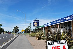
801:West Melton has a shopping precinct including a
1402:
1078:
1076:
875:On 20 March 2023, West Melton's first set of
657:, an increase of 246 people (5.2%) since the
8:
1299:"Moore Park Motorcycle Speedway, Canterbury"
1104:"Statistical area 1 dataset for 2018 Census"
1084:"Statistical area 1 dataset for 2018 Census"
593:
433:
1349:"Historyczne Zestawienie Wynikow 1929-2023"
812:and a domain, as well as a primary school.
21:Minor urban area in Canterbury, New Zealand
1993:
1513:
1445:
1409:
1395:
1387:
712:
592:
432:
390:. Recently, it has become associated with
23:
2090:Populated places in the Canterbury Region
1012:"The growing West Melton | West Melton"
911:
311:
273:
252:
244:
231:
164:
142:
92:
57:
53:
41:
1089:2018 Census place summary: West Melton
959:"Population estimate tables - NZ.Stat"
921:
919:
917:
915:
898:events and has held the final of the
290:
265:
257:
236:
218:
205:
192:
182:
169:
134:
126:
114:
102:
16:Settlement in Canterbury, New Zealand
7:
1198:"Darfield/City | Metro Christchurch"
1142:Education Counts: West Melton School
1006:
1004:
872:via Weedons Ross Road Interchange.
1156:. New Zealand Ministry of Education
1034:"Sunday Celebrations | West Melton"
241:2.99 km (1.15 sq mi)
1919:Whitecliffs Branch historical site
816:is located in the area, as is the
14:
844:West Melton is serviced with the
668:Ethnicities were 93.1% European/
519:Ethnicities were 94.0% European/
43:
1154:"New Zealand Schools Directory"
818:Canterbury Astronomical Society
374:St Paul's Anglican church, 2013
1249:"Selwyn_Times: March 22, 2023"
1176:"Haere Mai, Nau Mai - Welcome"
902:in 2012, 2015, 2018 and 2021.
870:Christchurch Southern Motorway
706:and 1.0% had other religions.
557:and 1.3% had other religions.
348:Christchurch metropolitan area
1:
2004:Arthur's Pass railway station
1837:Arthur Dudley Dobson Memorial
900:New Zealand Solo Championship
184: • Regional council
797:West Melton community centre
426:West Melton is described by
2019:Springfield railway station
1872:Midland Rail Heritage Trust
1796:Lake Ellesmere / Te Waihora
1303:Speedway Racing New Zealand
864:West Melton is accessed by
394:and deer farming. In 1881,
2106:
1830:Facilities and attractions
2014:Rolleston railway station
1904:Terrace Station Homestead
1428:
1382:West Melton & Halkett
646:
620:—
497:
460:—
306:New Zealand Daylight Time
285:New Zealand Standard Time
270:820/km (2,100/sq mi)
58:
54:
42:
33:
2009:Darfield railway station
1976:Pineglades Naturist Club
1771:Coopers Lagoon / Muriwai
927:"ArcGIS Web Application"
352:123rd-largest urban area
49:West Melton Tavern, 2011
1882:RNZAF Station Te Pirita
1877:R. F. Joyce Observatory
1862:Little River Rail Trail
1857:Hororata Highland Games
1847:Craigieburn Forest Park
1377:Selwyn District Council
1122:Selwyn District Council
1060:Selwyn District Council
931:statsnz.maps.arcgis.com
696:Māori religious beliefs
655:2018 New Zealand census
506:2018 New Zealand census
249:88 m (289 ft)
178:Selwyn District Council
963:Statistics New Zealand
798:
428:Statistics New Zealand
375:
188:Environment Canterbury
1914:West Melton Aerodrome
1842:Burnham Military Camp
866:State Highway 73
814:West Melton Aerodrome
796:
584:Burnham Military Camp
434:Historical population
373:
293: • Summer (
173:Territorial authority
117:Territorial authority
1961:Darfield High School
1888:Springfield Doughnut
1517:Hawkins Sub-Division
1178:. West Melton School
854:Central Christchurch
267: • Density
2040:Inland Scenic Route
1971:Lincoln High School
1867:McHughs Forest Park
1744:Geographic features
1668:Selwyn Central Ward
1585:Castle Hill Village
1563:Tawera Sub-Division
1328:Moore Park Speedway
1202:www.metroinfo.co.nz
1014:. 30 September 2014
896:motorcycle speedway
892:motorcycle speedway
888:Moore Park Speedway
715:
595:
435:
346:and is part of the
74: /
1899:St Joseph's Church
1852:Homebush Homestead
1821:Waianiwaniwa River
799:
713:
376:
259: • Total
238: • Total
78:43.517°S 172.367°E
2072:
2071:
2068:
2067:
1981:Rolleston College
1966:Ellesmere College
1739:
1738:
1663:
1662:
1645:Waimakariri Gorge
988:www.stats.govt.nz
786:
785:
651:
650:
574:Waimakariri River
502:
501:
338:of New Zealand's
336:Canterbury region
330:is a town in the
325:
324:
2097:
2060:State Highway 77
2055:State Highway 75
2050:State Highway 73
1994:
1945:Regional Council
1935:District Council
1894:St John's Church
1514:
1446:
1442:Populated places
1411:
1404:
1397:
1388:
1364:
1363:
1361:
1359:
1353:Speedway History
1345:
1339:
1338:
1336:
1334:
1320:
1314:
1313:
1311:
1309:
1295:
1289:
1288:
1286:
1284:
1270:
1264:
1263:
1261:
1259:
1244:
1238:
1237:
1235:
1233:
1227:www.nzta.govt.nz
1219:
1213:
1212:
1210:
1208:
1194:
1188:
1187:
1185:
1183:
1172:
1166:
1165:
1163:
1161:
1150:
1144:
1139:
1133:
1132:
1130:
1128:
1114:
1108:
1107:
1100:
1091:
1087:
1080:
1071:
1070:
1068:
1066:
1052:
1046:
1045:
1043:
1041:
1036:. 6 October 2014
1030:
1024:
1023:
1021:
1019:
1008:
999:
998:
996:
994:
980:
974:
973:
971:
969:
955:
942:
941:
939:
937:
923:
810:community centre
716:
609:
604:
596:
449:
444:
436:
298:
174:
89:
88:
86:
85:
84:
83:-43.517; 172.367
79:
75:
72:
71:
70:
67:
47:
36:Minor urban area
24:
2105:
2104:
2100:
2099:
2098:
2096:
2095:
2094:
2085:Selwyn District
2075:
2074:
2073:
2064:
2045:State Highway 1
2028:
1985:
1949:
1923:
1825:
1735:
1689:
1659:
1558:
1505:
1437:
1424:
1418:Selwyn District
1415:
1373:
1368:
1367:
1357:
1355:
1347:
1346:
1342:
1332:
1330:
1322:
1321:
1317:
1307:
1305:
1297:
1296:
1292:
1282:
1280:
1272:
1271:
1267:
1257:
1255:
1246:
1245:
1241:
1231:
1229:
1221:
1220:
1216:
1206:
1204:
1196:
1195:
1191:
1181:
1179:
1174:
1173:
1169:
1159:
1157:
1152:
1151:
1147:
1140:
1136:
1126:
1124:
1116:
1115:
1111:
1102:
1101:
1094:
1082:
1081:
1074:
1064:
1062:
1054:
1053:
1049:
1039:
1037:
1032:
1031:
1027:
1017:
1015:
1010:
1009:
1002:
992:
990:
982:
981:
977:
967:
965:
957:
956:
945:
935:
933:
925:
924:
913:
908:
885:
862:
842:
837:
829:
791:
567:
565:Rural surrounds
424:
407:
405:Urban expansion
396:Alfred Saunders
368:
332:Selwyn District
292:
222:Te Tai Tonga MP
196:Mayor of Selwyn
172:
161:
122:Selwyn District
82:
80:
76:
73:
68:
65:
63:
61:
60:
50:
38:
29:
22:
17:
12:
11:
5:
2103:
2101:
2093:
2092:
2087:
2077:
2076:
2070:
2069:
2066:
2065:
2063:
2062:
2057:
2052:
2047:
2042:
2036:
2034:
2030:
2029:
2027:
2026:
2021:
2016:
2011:
2006:
2000:
1998:
1991:
1990:Transportation
1987:
1986:
1984:
1983:
1978:
1973:
1968:
1963:
1957:
1955:
1951:
1950:
1948:
1947:
1942:
1937:
1931:
1929:
1925:
1924:
1922:
1921:
1916:
1911:
1906:
1901:
1896:
1891:
1884:
1879:
1874:
1869:
1864:
1859:
1854:
1849:
1844:
1839:
1833:
1831:
1827:
1826:
1824:
1823:
1818:
1813:
1808:
1803:
1798:
1793:
1788:
1783:
1781:Hororata River
1778:
1773:
1768:
1763:
1758:
1753:
1747:
1745:
1741:
1740:
1737:
1736:
1734:
1733:
1728:
1723:
1718:
1713:
1708:
1703:
1697:
1695:
1691:
1690:
1688:
1687:
1682:
1677:
1671:
1669:
1665:
1664:
1661:
1660:
1658:
1657:
1652:
1647:
1642:
1637:
1632:
1627:
1622:
1617:
1615:Lake Coleridge
1612:
1607:
1602:
1597:
1592:
1587:
1582:
1577:
1572:
1566:
1564:
1560:
1559:
1557:
1556:
1551:
1546:
1541:
1536:
1531:
1526:
1520:
1518:
1511:
1507:
1506:
1504:
1503:
1498:
1493:
1488:
1483:
1478:
1473:
1468:
1463:
1458:
1452:
1450:
1449:Ellesmere Ward
1443:
1439:
1438:
1429:
1426:
1425:
1416:
1414:
1413:
1406:
1399:
1391:
1385:
1384:
1379:
1372:
1371:External links
1369:
1366:
1365:
1340:
1315:
1290:
1265:
1239:
1214:
1189:
1167:
1145:
1134:
1109:
1092:
1072:
1047:
1025:
1000:
975:
943:
910:
909:
907:
904:
884:
881:
877:traffic lights
861:
858:
841:
838:
836:
833:
828:
825:
790:
787:
784:
783:
780:
777:
774:
771:
767:
766:
763:
760:
757:
754:
750:
749:
746:
743:
740:
737:
733:
732:
731:Median income
729:
726:
723:
720:
649:
648:
644:
643:
640:
637:
633:
632:
629:
626:
622:
621:
618:
615:
611:
610:
605:
600:
566:
563:
500:
499:
495:
494:
491:
488:
484:
483:
480:
477:
473:
472:
469:
466:
462:
461:
458:
455:
451:
450:
445:
440:
423:
420:
406:
403:
367:
364:
323:
322:
317:
310:
309:
299:
289:
288:
278:
272:
271:
268:
264:
263:
260:
256:
255:
251:
250:
247:
243:
242:
239:
235:
234:
230:
229:
224:
217:
216:
211:
204:
203:
198:
191:
190:
185:
181:
180:
175:
168:
167:
163:
162:
160:
159:
153:
147:
145:
141:
140:
137:
133:
132:
129:
125:
124:
119:
113:
112:
107:
101:
100:
97:
91:
90:
56:
55:
52:
51:
48:
40:
39:
34:
31:
30:
27:
20:
15:
13:
10:
9:
6:
4:
3:
2:
2102:
2091:
2088:
2086:
2083:
2082:
2080:
2061:
2058:
2056:
2053:
2051:
2048:
2046:
2043:
2041:
2038:
2037:
2035:
2031:
2025:
2022:
2020:
2017:
2015:
2012:
2010:
2007:
2005:
2002:
2001:
1999:
1995:
1992:
1988:
1982:
1979:
1977:
1974:
1972:
1969:
1967:
1964:
1962:
1959:
1958:
1956:
1954:Organisations
1952:
1946:
1943:
1941:
1938:
1936:
1933:
1932:
1930:
1926:
1920:
1917:
1915:
1912:
1910:
1907:
1905:
1902:
1900:
1897:
1895:
1892:
1890:
1889:
1885:
1883:
1880:
1878:
1875:
1873:
1870:
1868:
1865:
1863:
1860:
1858:
1855:
1853:
1850:
1848:
1845:
1843:
1840:
1838:
1835:
1834:
1832:
1828:
1822:
1819:
1817:
1814:
1812:
1809:
1807:
1804:
1802:
1799:
1797:
1794:
1792:
1789:
1787:
1784:
1782:
1779:
1777:
1776:Hawkins River
1774:
1772:
1769:
1767:
1764:
1762:
1759:
1757:
1754:
1752:
1751:Arthur's Pass
1749:
1748:
1746:
1742:
1732:
1729:
1727:
1724:
1722:
1719:
1717:
1714:
1712:
1709:
1707:
1704:
1702:
1699:
1698:
1696:
1692:
1686:
1683:
1681:
1678:
1676:
1673:
1672:
1670:
1666:
1656:
1653:
1651:
1648:
1646:
1643:
1641:
1638:
1636:
1633:
1631:
1628:
1626:
1623:
1621:
1618:
1616:
1613:
1611:
1608:
1606:
1603:
1601:
1598:
1596:
1593:
1591:
1588:
1586:
1583:
1581:
1578:
1576:
1575:Arthur's Pass
1573:
1571:
1568:
1567:
1565:
1561:
1555:
1552:
1550:
1547:
1545:
1542:
1540:
1537:
1535:
1532:
1530:
1527:
1525:
1522:
1521:
1519:
1515:
1512:
1508:
1502:
1499:
1497:
1494:
1492:
1489:
1487:
1484:
1482:
1479:
1477:
1474:
1472:
1469:
1467:
1464:
1462:
1459:
1457:
1454:
1453:
1451:
1447:
1444:
1440:
1436:
1432:
1427:
1423:
1419:
1412:
1407:
1405:
1400:
1398:
1393:
1392:
1389:
1383:
1380:
1378:
1375:
1374:
1370:
1354:
1350:
1344:
1341:
1329:
1325:
1319:
1316:
1304:
1300:
1294:
1291:
1279:
1275:
1269:
1266:
1254:
1250:
1243:
1240:
1228:
1224:
1218:
1215:
1203:
1199:
1193:
1190:
1177:
1171:
1168:
1155:
1149:
1146:
1143:
1138:
1135:
1123:
1119:
1118:"Skate parks"
1113:
1110:
1105:
1099:
1097:
1093:
1090:
1085:
1079:
1077:
1073:
1061:
1057:
1051:
1048:
1035:
1029:
1026:
1013:
1007:
1005:
1001:
989:
985:
979:
976:
964:
960:
954:
952:
950:
948:
944:
932:
928:
922:
920:
918:
916:
912:
905:
903:
901:
897:
893:
889:
882:
880:
878:
873:
871:
867:
859:
857:
855:
851:
847:
839:
834:
832:
826:
824:
821:
819:
815:
811:
807:
804:
795:
788:
781:
778:
775:
772:
770:Newtons Road
769:
768:
764:
761:
758:
755:
752:
751:
747:
744:
741:
738:
735:
734:
730:
727:
724:
721:
718:
717:
711:
707:
705:
701:
697:
693:
688:
685:
683:
679:
675:
671:
666:
664:
660:
656:
645:
641:
638:
635:
634:
630:
627:
624:
623:
619:
616:
613:
612:
606:
601:
598:
597:
591:
589:
585:
581:
577:
575:
571:
564:
562:
558:
556:
552:
548:
544:
539:
536:
534:
530:
526:
522:
517:
515:
511:
507:
496:
492:
489:
486:
485:
481:
478:
475:
474:
470:
467:
464:
463:
459:
456:
453:
452:
446:
441:
438:
437:
431:
429:
421:
419:
415:
411:
404:
402:
399:
397:
393:
389:
388:sheep farming
385:
381:
372:
365:
363:
361:
357:
353:
349:
345:
341:
337:
333:
329:
321:
318:
316:
307:
303:
300:
296:
286:
282:
279:
277:
269:
261:
248:
240:
228:
227:Tākuta Ferris
225:
223:
220: •
215:
212:
210:
207: •
202:
201:Sam Broughton
199:
197:
194: •
189:
186:
179:
176:
171: •
157:
154:
152:
149:
148:
146:
138:
130:
123:
120:
118:
111:
108:
106:
98:
96:
87:
59:Coordinates:
46:
37:
32:
25:
19:
1886:
1816:Selwyn River
1811:Porters Pass
1806:Porter River
1756:Broken River
1694:Springs Ward
1684:
1625:Rakaia Gorge
1510:Malvern Ward
1356:. Retrieved
1352:
1343:
1331:. Retrieved
1327:
1318:
1306:. Retrieved
1302:
1293:
1281:. Retrieved
1277:
1274:"Track Info"
1268:
1256:. Retrieved
1252:
1242:
1232:30 September
1230:. Retrieved
1226:
1217:
1207:21 September
1205:. Retrieved
1201:
1192:
1180:. Retrieved
1170:
1160:17 September
1158:. Retrieved
1148:
1137:
1125:. Retrieved
1121:
1112:
1063:. Retrieved
1059:
1050:
1038:. Retrieved
1028:
1016:. Retrieved
991:. Retrieved
987:
978:
966:. Retrieved
934:. Retrieved
930:
886:
874:
863:
846:86 bus route
843:
830:
822:
800:
736:West Melton
708:
702:, 0.3% were
698:, 0.1% were
689:
686:
667:
652:
580:Newtons Road
579:
578:
569:
568:
559:
553:, 1.0% were
549:, 0.3% were
545:, 0.1% were
540:
537:
518:
503:
425:
422:Demographics
416:
412:
408:
400:
392:wine growing
382:(trotting),
380:horse racing
377:
344:Christchurch
340:South Island
327:
326:
214:Nicola Grigg
156:Te Tai Tonga
18:
2024:TranzAlpine
1909:The Station
1801:Lake Lyndon
1786:Kowai River
1766:Castle Hill
1685:West Melton
1655:Windwhistle
1650:Whitecliffs
1635:Springfield
1620:Lake Lyndon
1595:Craigieburn
1501:Southbridge
1496:Selwyn Huts
1422:New Zealand
1358:13 February
1333:13 February
1308:13 February
1283:13 February
1247:Yumpu.com.
1127:21 February
1065:10 December
1040:10 December
1018:10 December
806:supermarket
803:Four Square
779:45.2 years
762:46.2 years
745:39.7 years
728:Median age
722:Population
694:, 0.1% had
663:2006 census
659:2013 census
514:2006 census
510:2013 census
358:and before
328:West Melton
144:Electorates
99:New Zealand
81: /
28:West Melton
2079:Categories
1928:Government
1791:L II River
1761:Cass River
1721:Springston
1716:Prebbleton
1701:Broadfield
1640:Waddington
1600:Glentunnel
1486:Motukarara
1182:19 October
968:25 October
906:References
725:Dwellings
254:Population
166:Government
110:Canterbury
1731:Templeton
1706:Ladbrooks
1675:Rolleston
1630:Sheffield
1549:Kimberley
1539:Greendale
1529:Courtenay
1524:Aylesbury
1471:Ellesmere
1466:Dunsandel
1461:Doyleston
1435:Rolleston
1253:yumpu.com
852:with the
835:Transport
827:Education
782:$ 39,600
765:$ 38,800
748:$ 55,400
719:SA2 name
692:Christian
588:Rolleston
543:Christian
334:, in the
320:Ngāi Tahu
276:Time zone
246:Elevation
209:Selwyn MP
136:Community
1726:Tai Tapu
1610:Hororata
1605:Homebush
1590:Coalgate
1534:Darfield
936:28 March
850:Darfield
789:Services
753:Halkett
704:Buddhist
678:Pasifika
647:Source:
555:Buddhist
529:Pasifika
498:Source:
384:cropping
356:Darfield
69:172°22′E
1711:Lincoln
1544:Hawkins
1481:Leeston
1456:Burnham
1258:3 April
993:23 June
680:, 2.6%
676:, 1.4%
672:, 7.6%
608:±% p.a.
570:Halkett
531:, 5.2%
527:, 0.9%
523:, 5.9%
482:+21.73%
471:+13.22%
448:±% p.a.
366:History
360:Leeston
158:(Māori)
139:Malvern
131:Malvern
95:Country
66:43°31′S
1554:Kirwee
1491:Selwyn
1476:Irwell
1324:"Home"
1278:Sporty
776:1,113
773:3,342
756:1,656
739:2,085
700:Muslim
670:Pākehā
642:+1.01%
631:+2.90%
551:Muslim
521:Pākehā
493:+3.28%
386:, and
313:Local
302:UTC+13
281:UTC+12
151:Selwyn
105:Region
1940:Mayor
1680:Izone
1570:Avoca
890:is a
883:Sport
682:Asian
674:Māori
639:4,998
628:4,752
617:3,891
547:Hindu
533:Asian
525:Māori
490:2,450
479:2,085
262:2,450
2033:Road
1997:Rail
1580:Cass
1431:Seat
1360:2024
1335:2024
1310:2024
1285:2024
1260:2023
1234:2020
1209:2020
1184:2021
1162:2024
1129:2024
1067:2022
1042:2022
1020:2022
995:2021
970:2023
938:2024
860:Road
759:585
742:675
636:2018
625:2013
614:2006
603:Pop.
599:Year
586:and
487:2023
476:2018
465:2013
454:2006
443:Pop.
439:Year
233:Area
128:Ward
840:Bus
468:780
457:327
362:).
315:iwi
295:DST
2081::
1433::
1420:,
1351:.
1326:.
1301:.
1276:.
1251:.
1225:.
1200:.
1120:.
1095:^
1075:^
1058:.
1003:^
986:.
961:.
946:^
929:.
914:^
856:.
820:.
808:,
1410:e
1403:t
1396:v
1362:.
1337:.
1312:.
1287:.
1262:.
1236:.
1211:.
1186:.
1164:.
1131:.
1069:.
1044:.
1022:.
997:.
972:.
940:.
308:)
304:(
297:)
287:)
283:(
Text is available under the Creative Commons Attribution-ShareAlike License. Additional terms may apply.