26:
133:
website. One is shown as
Limekiln Close and West Pit on the details page, but the map only covers Limekiln Close. The other LNR is shown on the details page as East Pit, whereas the map covers both East and West Pits.
398:
110:
This former chalk quarry is now steeply sloping woodland with a caravan park in the centre. The woodland has been designated an SSSI due to the presence of a plant on the
British
391:
639:
384:
407:
216:
326:
282:
59:
184:
501:
104:
524:
304:
347:
603:
575:
547:
468:
53:
260:
618:
613:
473:
453:
129:, which shows it as one LNR and East Pit and Limekiln Close as another LNR. However, the LNRs are confused on the
238:
191:
496:
126:
595:
557:
122:
88:
570:
488:
448:
542:
458:
100:
159:
511:
115:
534:
519:
376:
130:
443:
585:
580:
565:
633:
438:
428:
423:
111:
92:
137:
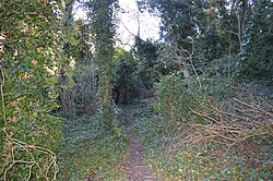
There is access to the site from the entrance to the caravan park on
Limekiln Road.
463:
433:
362:
349:
415:
96:
608:
190:. Sites of Special Scientific Interest. Natural England. Archived from
25:
380:
307:. Local Nature Reserves. Natural England. 20 February 2013
263:. Local Nature Reserves. Natural England. 20 February 2013
219:. Sites of Special Scientific Interest. Natural England
594:
556:
533:
510:
487:
414:
74:
66:
52:
44:
36:
18:
239:"Limekiln Close and East Pit local nature reserve"
107:(SSSI), which includes the neighbouring East Pit.
392:
8:
399:
385:
377:
154:
152:
150:
15:
329:. Local Nature Reserves. Natural England
285:. Local Nature Reserves. Natural England
640:Local Nature Reserves in Cambridgeshire
408:Local nature reserves in Cambridgeshire
146:
179:
177:
7:
283:"Map of Limekiln Close and West Pit"
95:, on the south-eastern outskirts of
35:
105:Site of Special Scientific Interest
14:
43:
24:
121:The site has been designated a
73:
65:
604:Kingston and Bourn Old Railway
112:Red List of Threatened Species
1:
261:"Limekiln Close and West Pit"
48:Cherry Hinton, Cambridgeshire
185:"Cherry Hinton Pit citation"
454:Limekiln Close and East Pit
656:
217:"Map of Cherry Hinton Pit"
474:Sheep's Green and Coe Fen
32:
23:
241:. Cambridge City Council
162:. Cambridge City Council
127:Cambridge City Council
78:Cambridge City Council
596:South Cambridgeshire
123:Local Nature Reserve
99:. It is part of the
89:Local Nature Reserve
40:Local Nature Reserve
571:Dogsthorpe Star Pit
489:East Cambridgeshire
359: /
543:Little Paxton Pits
197:on 24 October 2012
627:
626:
327:"Map of East Pit"
101:Cherry Hinton Pit
87:is a 4.3 hectare
82:
81:
647:
449:Coldham's Common
401:
394:
387:
378:
374:
373:
371:
370:
369:
364:
363:52.182°N 0.169°E
360:
357:
356:
355:
352:
339:
338:
336:
334:
323:
317:
316:
314:
312:
301:
295:
294:
292:
290:
279:
273:
272:
270:
268:
257:
251:
250:
248:
246:
235:
229:
228:
226:
224:
213:
207:
206:
204:
202:
196:
189:
181:
172:
171:
169:
167:
156:
62:
28:
16:
655:
654:
650:
649:
648:
646:
645:
644:
630:
629:
628:
623:
619:St Denis Church
590:
552:
535:Huntingdonshire
529:
520:Lattersey Field
506:
483:
410:
405:
367:
365:
361:
358:
353:
350:
348:
346:
345:
343:
342:
332:
330:
325:
324:
320:
310:
308:
303:
302:
298:
288:
286:
281:
280:
276:
266:
264:
259:
258:
254:
244:
242:
237:
236:
232:
222:
220:
215:
214:
210:
200:
198:
194:
187:
183:
182:
175:
165:
163:
158:
157:
148:
143:
131:Natural England
75:Managed by
58:
12:
11:
5:
653:
651:
643:
642:
632:
631:
625:
624:
622:
621:
616:
611:
606:
600:
598:
592:
591:
589:
588:
586:Woodston Ponds
583:
581:Grimeshaw Wood
578:
573:
568:
566:The Boardwalks
562:
560:
554:
553:
551:
550:
545:
539:
537:
531:
530:
528:
527:
522:
516:
514:
508:
507:
505:
504:
502:Little Downham
499:
493:
491:
485:
484:
482:
481:
476:
471:
466:
461:
459:Logan's Meadow
456:
451:
446:
441:
436:
431:
426:
420:
418:
412:
411:
406:
404:
403:
396:
389:
381:
341:
340:
318:
296:
274:
252:
230:
208:
173:
145:
144:
142:
139:
80:
79:
76:
72:
71:
68:
64:
63:
56:
50:
49:
46:
42:
41:
38:
34:
33:
30:
29:
21:
20:
13:
10:
9:
6:
4:
3:
2:
652:
641:
638:
637:
635:
620:
617:
615:
612:
610:
607:
605:
602:
601:
599:
597:
593:
587:
584:
582:
579:
577:
574:
572:
569:
567:
564:
563:
561:
559:
555:
549:
546:
544:
541:
540:
538:
536:
532:
526:
523:
521:
518:
517:
515:
513:
509:
503:
500:
498:
495:
494:
492:
490:
486:
480:
477:
475:
472:
470:
467:
465:
462:
460:
457:
455:
452:
450:
447:
445:
442:
440:
439:Bramblefields
437:
435:
432:
430:
429:Barnwell West
427:
425:
424:Barnwell East
422:
421:
419:
417:
413:
409:
402:
397:
395:
390:
388:
383:
382:
379:
375:
372:
368:52.182; 0.169
328:
322:
319:
306:
300:
297:
284:
278:
275:
262:
256:
253:
240:
234:
231:
218:
212:
209:
193:
186:
180:
178:
174:
161:
155:
153:
151:
147:
140:
138:
135:
132:
128:
124:
119:
117:
113:
108:
106:
102:
98:
94:
93:Cherry Hinton
90:
86:
77:
69:
61:
57:
55:
51:
47:
39:
31:
27:
22:
17:
558:Peterborough
478:
444:Byron's Pool
344:
331:. Retrieved
321:
309:. Retrieved
299:
287:. Retrieved
277:
265:. Retrieved
255:
243:. Retrieved
233:
221:. Retrieved
211:
199:. Retrieved
192:the original
164:. Retrieved
136:
120:
109:
84:
83:
70:4.3 hectares
366: /
223:30 November
201:30 November
116:moon carrot
103:biological
525:Ring's End
464:Nine Wells
434:Beechwoods
351:52°10′55″N
333:15 January
311:15 January
305:"East Pit"
289:15 January
267:15 January
245:16 January
166:15 January
160:"West Pit"
141:References
60:TL 484 558
576:Eye Green
548:Somersham
416:Cambridge
354:0°10′08″E
125:(LNR) by
97:Cambridge
634:Category
609:Mare Fen
479:West Pit
469:Paradise
85:West Pit
45:Location
19:West Pit
614:Melwood
512:Fenland
497:Isleham
54:OS grid
114:, the
195:(PDF)
188:(PDF)
335:2017
313:2017
291:2017
269:2017
247:2017
225:2016
203:2016
168:2017
67:Area
37:Type
91:in
636::
176:^
149:^
118:.
400:e
393:t
386:v
337:.
315:.
293:.
271:.
249:.
227:.
205:.
170:.
Text is available under the Creative Commons Attribution-ShareAlike License. Additional terms may apply.