29:
749:
410:
139:
514:
Tectonic units of the
Western Carpathians are arranged in belt-like order, with the external units in the north and internal units in the south. Alpine evolution of the Western Carpathians is dominated by extension and closure of two or three oceanic domains: Triassic-Jurassic
817:
1033:
620:
1023:
592:
Geologica
Carpathica Special Issues, 53, Proceedings of XVII. Congress of Carpathian-Balkan Geological Association Bratislava, September 1st - 4th 2002
99:
728:
724:
748:
328:
Most of the perimeter of the
Western Carpathians is quite sharply defined by valleys. To the northwest and north they are separated from the
1048:
1038:
1028:
585:
1043:
613:
404:
854:
956:
864:
827:
673:
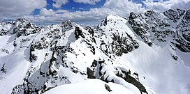
784:
606:
1018:
874:
789:
705:
629:
323:
92:
710:
807:
715:
700:
34:
528:
311:
75:
887:
859:
799:
766:
692:
682:
650:
536:
303:
148:
144:
668:
540:
598:
516:
465:
333:
972:
547:
395:, but it is less striking and passes through highland terrain that continues to the Eastern Carpathians.
997:
992:
977:
946:
54:
779:
388:
50:
46:
42:
982:
841:
678:
658:
633:
453:
337:
269:
199:
987:
950:
902:
774:
757:
734:
441:
310:. The area of the Western Carpathians comprises about 70,000 km. The highest elevation is the
58:
468:. The southern boundary is less clear, because later postorogenetic evolution caused formation of
16:
Mountain range along the border between Poland, Austria, the Czech
Republic, Slovakia, and Hungary
821:
543:
520:
372:
223:
38:
475:
The
Western Carpathians have a complicated geological structure, that has been formed since the
910:
882:
484:
469:
849:
663:
580:
532:
392:
892:
812:
720:
589:
457:
349:
329:
508:
504:
488:
480:
418:
292:
261:
253:
216:
192:
162:
28:
1012:
376:
341:
265:
177:
524:
500:
437:
422:
368:
364:
357:
539:, and consuming the crust of Carpathian Flysch Basins caused the formation of the
582:
Origin and growth of the
Western Carpathian orogenetic wedge during the mesozoic.
429:
299:
276:
185:
930:
436:, but the exact boundary is hidden under the Neogene sedimentary fill of the
114:
101:
476:
449:
380:
236:
232:
445:
915:
492:
284:
240:
496:
345:
307:
296:
288:
228:
211:
181:
138:
920:
384:
280:
166:
82:
409:
925:
461:
408:
507:
and
Western Carpathian blocks were thrust over the margin of the
433:
353:
602:
387:. To the east and northeast the mountains are bounded by the
417:
The
Western Carpathians are part of the northern branch of
348:. To the south the mountain chain falls away towards the
483:
experienced the first stage of deformation during the
143:
Carpathian
Mountains, Western Carpathians in green (1=
363:
The boundary between the
Western Carpathians and the
279:
range of the Eastern Carpathians along the border of
965:
939:
901:
873:
840:
798:
765:
756:
691:
649:
640:
222:
210:
205:
191:
173:
157:
130:
91:
81:
71:
66:
21:
472:, penetrating the mountain chain non-uniformly.
360:, and the main mass of the Eastern Carpathians.
527:. After a subduction of the Meliata Ocean, the
614:
8:
268:province that forms the western part of the
535:of Vahic domain finalized thrusting in the
432:. To the west they longitudinally join the
762:
646:
621:
607:
599:
487:, but younger Alpine overprint is common.
18:
491:affected the area in several stages from
421:, which was formed by the closure of the
428:The Western Carpathians are part of the
568:Encyklopédia Slovenska. VI. zväzok T-Ž.
559:
440:. To the east, their boundary with the
1034:Mountain ranges of the Czech Republic
413:Geological map of Western Carpathians
352:, a large plain situated between the
275:The mountain belt stretches from the
7:
37:, Poland. Peaks from left to right:
1024:Mountain ranges of the Carpathians
405:Geology of the Western Carpathians
14:
452:. The northern boundary with the
747:
460:is well marked by the thrust of
137:
27:
957:Outer Subcarpathian depressions
865:Retezat-Godeanu Mountains group
828:Moldavian-Muntenian Carpathians
499:. During this period, parts of
1:
875:Western Romanian Carpathians
706:Central Moravian Carpathians
632:, Groups, and Ranges of the
529:Internal Western Carpathians
371:, the Hainburg Hills of the
324:Divisions of the Carpathians
87:2,655 m (8,711 ft)
1049:Mountain ranges of Slovakia
711:Slovak-Moravian Carpathians
537:Central Western Carpathians
1065:
1039:Mountain ranges of Hungary
1029:Mountain ranges of Austria
808:Central Beskidian Piedmont
785:Căliman-Harghita Mountains
716:Western Beskidian Piedmont
701:South-Moravian Carpathians
566:Vladár, J. (Editor) 1982:
479:era. The oldest Paleozoic
402:
321:
1044:Mountain ranges of Poland
790:Giurgeu-Brașov Depression
745:
683:North Hungarian Mountains
674:Lučenec-Košice Depression
503:were subducted under the
304:North Hungarian Mountains
149:Inner Western Carpathians
145:Outer Western Carpathians
135:
26:
669:Slovak Central Mountains
570:Bratislava, Veda, p. 497
541:External West Carpathian
523:and Cretaceous-Tertiary
521:Piemont-Vahic Ocean/Zone
855:Făgăraș Mountains group
425:millions of years ago.
318:Geographical definition
888:Poiana Ruscă Mountains
860:Parâng Mountains group
519:, Jurassic-Cretaceous
517:Meliata-Halstatt Ocean
466:Carpathian flysch belt
414:
334:Forecarpathian Lowland
257:
998:Ukrainian Carpathians
973:Hungarian Carpathians
947:Transylvanian Plateau
579:Plašienka, D., 2002:
444:is the valley of the
412:
115:49.16722°N 20.13111°E
983:Romanian Carpathians
842:Southern Carpathians
659:Slovak Ore Mountains
634:Carpathian Mountains
454:East European craton
338:Lesser Poland Upland
270:Carpathian Mountains
200:Carpathian Mountains
33:Panoramic view from
1019:Western Carpathians
988:Serbian Carpathians
966:Grouping by country
951:Transylvanian Plain
903:Serbian Carpathians
775:Vihorlat-Gutin Area
758:Eastern Carpathians
735:Podhale-Magura Area
642:Western Carpathians
525:Valais-Magura Ocean
442:Eastern Carpathians
302:. In the south the
250:Western Carpathians
161:Slovakia, Austria,
111: /
22:Western Carpathians
993:Slovak Carpathians
978:Polish Carpathians
822:Polonynian Beskids
780:Bistrița Mountains
588:2011-10-07 at the
544:accretionary wedge
415:
373:Little Carpathians
344:leads over to the
340:; to the west the
120:49.16722; 20.13111
67:Highest point
55:Gąsienicowa Turnia
1006:
1005:
911:Homolje Mountains
883:Apuseni Mountains
836:
835:
743:
742:
679:Mátra-Slanec Area
485:Hercynian orogeny
393:Sandomierz Basins
367:is formed by the
312:Gerlachovský štít
246:
245:
76:Gerlachovský štít
1056:
940:Adjacent regions
850:Bucegi Mountains
763:
751:
664:Fatra-Tatra Area
647:
623:
616:
609:
600:
593:
577:
571:
564:
266:geomorphological
195:
141:
126:
125:
123:
122:
121:
116:
112:
109:
108:
107:
104:
51:Niebieska Turnia
47:Zawratowa Turnia
43:Mały Kozi Wierch
31:
19:
1064:
1063:
1059:
1058:
1057:
1055:
1054:
1053:
1009:
1008:
1007:
1002:
961:
935:
916:Kučaj Mountains
897:
893:Banat Mountains
869:
832:
818:Eastern Beskids
813:Central Beskids
794:
752:
739:
729:Central section
725:Eastern section
721:Western Beskids
687:
636:
627:
597:
596:
590:Wayback Machine
578:
574:
565:
561:
556:
458:Bohemian Massif
407:
401:
350:Pannonian Plain
330:Bohemian Massif
326:
320:
306:cover northern
258:Západní Karpaty
193:
153:
152:
119:
117:
113:
110:
105:
102:
100:
98:
97:
62:
17:
12:
11:
5:
1062:
1060:
1052:
1051:
1046:
1041:
1036:
1031:
1026:
1021:
1011:
1010:
1004:
1003:
1001:
1000:
995:
990:
985:
980:
975:
969:
967:
963:
962:
960:
959:
954:
943:
941:
937:
936:
934:
933:
928:
923:
918:
913:
907:
905:
899:
898:
896:
895:
890:
885:
879:
877:
871:
870:
868:
867:
862:
857:
852:
846:
844:
838:
837:
834:
833:
831:
830:
825:
815:
810:
804:
802:
796:
795:
793:
792:
787:
782:
777:
771:
769:
760:
754:
753:
746:
744:
741:
740:
738:
737:
732:
718:
713:
708:
703:
697:
695:
689:
688:
686:
685:
676:
671:
666:
661:
655:
653:
644:
638:
637:
628:
626:
625:
618:
611:
603:
595:
594:
572:
558:
557:
555:
552:
509:Eurasian Plate
505:Adriatic Plate
489:Alpine orogeny
419:alpine orogeny
403:Main article:
400:
397:
383:carved by the
319:
316:
293:Czech Republic
291:region of the
262:mountain range
244:
243:
226:
220:
219:
217:alpine orogeny
214:
208:
207:
203:
202:
197:
189:
188:
175:
171:
170:
163:Czech Republic
159:
155:
154:
142:
136:
133:
132:
128:
127:
95:
89:
88:
85:
79:
78:
73:
69:
68:
64:
63:
32:
24:
23:
15:
13:
10:
9:
6:
4:
3:
2:
1061:
1050:
1047:
1045:
1042:
1040:
1037:
1035:
1032:
1030:
1027:
1025:
1022:
1020:
1017:
1016:
1014:
999:
996:
994:
991:
989:
986:
984:
981:
979:
976:
974:
971:
970:
968:
964:
958:
955:
952:
948:
945:
944:
942:
938:
932:
929:
927:
924:
922:
919:
917:
914:
912:
909:
908:
906:
904:
900:
894:
891:
889:
886:
884:
881:
880:
878:
876:
872:
866:
863:
861:
858:
856:
853:
851:
848:
847:
845:
843:
839:
829:
826:
823:
819:
816:
814:
811:
809:
806:
805:
803:
801:
800:Outer Eastern
797:
791:
788:
786:
783:
781:
778:
776:
773:
772:
770:
768:
767:Inner Eastern
764:
761:
759:
755:
750:
736:
733:
730:
726:
722:
719:
717:
714:
712:
709:
707:
704:
702:
699:
698:
696:
694:
693:Outer Western
690:
684:
680:
677:
675:
672:
670:
667:
665:
662:
660:
657:
656:
654:
652:
651:Inner Western
648:
645:
643:
639:
635:
631:
624:
619:
617:
612:
610:
605:
604:
601:
591:
587:
584:
583:
576:
573:
569:
563:
560:
553:
551:
549:
545:
542:
538:
534:
531:were formed.
530:
526:
522:
518:
512:
510:
506:
502:
498:
494:
490:
486:
482:
478:
473:
471:
467:
463:
459:
455:
451:
447:
443:
439:
435:
431:
426:
424:
420:
411:
406:
398:
396:
394:
390:
386:
382:
378:
374:
370:
366:
361:
359:
355:
351:
347:
343:
342:Moravian Gate
339:
335:
331:
325:
317:
315:
313:
309:
305:
301:
298:
294:
290:
286:
282:
278:
273:
271:
267:
263:
259:
255:
251:
242:
238:
234:
230:
227:
225:
221:
218:
215:
213:
209:
204:
201:
198:
196:
190:
187:
183:
179:
178:Lesser Poland
176:
172:
168:
164:
160:
156:
150:
146:
140:
134:
129:
124:
96:
94:
90:
86:
84:
80:
77:
74:
70:
65:
60:
59:Świnicka Kopa
56:
52:
48:
44:
40:
36:
30:
25:
20:
641:
581:
575:
567:
562:
513:
501:Tethys Ocean
474:
438:Vienna Basin
427:
423:Tethys Ocean
416:
369:Vienna Basin
365:Eastern Alps
362:
358:Dinaric Alps
327:
274:
249:
247:
224:Type of rock
194:Parent range
548:Flysch Belt
430:Alpide belt
389:East Slovak
300:Weinviertel
287:toward the
277:Low Beskids
186:Weinviertel
169:and Hungary
118: /
93:Coordinates
39:Kozi Wierch
1013:Categories
931:Deli Jovan
554:References
377:Devín Gate
322:See also:
314:(2,655m).
630:Divisions
477:Paleozoic
450:Uzh River
237:sandstone
233:limestone
158:Countries
131:Geography
106:20°7′52″E
103:49°10′2″N
83:Elevation
35:Kościelec
586:Archived
533:Suturing
493:Jurassic
379:, and a
336:and the
297:Austrian
295:and the
289:Moravian
285:Slovakia
260:) are a
241:andesite
497:Neogene
464:of the
399:Geology
346:Sudetes
332:by the
308:Hungary
229:granite
212:Orogeny
206:Geology
182:Moravia
174:Regions
921:Devica
470:basins
462:nappes
446:Hornád
385:Danube
356:, the
281:Poland
167:Poland
57:, and
926:Rtanj
481:rocks
283:with
254:Czech
681:and
456:and
434:Alps
391:and
354:Alps
264:and
248:The
184:and
147:, 2=
72:Peak
550:).
495:to
448:or
381:gap
375:at
1015::
727:,
511:.
272:.
256::
239:,
235:,
231:,
180:,
165:,
53:,
49:,
45:,
41:,
953:)
949:(
824:)
820:(
731:)
723:(
622:e
615:t
608:v
546:(
252:(
151:)
61:.
Text is available under the Creative Commons Attribution-ShareAlike License. Additional terms may apply.