292:
137:
42:
130:
328:
Westerham Hill is the name given to the stretch of the A233 that ascends Betsom's Hill up to
Westerham Heights. On the 20th of August 1887 it was the venue for one of the earliest cycle hill climbs, even though it was considered nearly impossible to complete owing to the steep gradient of the then
238:
The crest of the hill was the location of a
Victorian defence fort, one of twelve locations along the North Downs built to protect London in case of attack by foreign invaders crossing the channel. Known as Betsom's Hill Fort or Westerham Fort, it was part of the
259:
The highest part of the hill is unmarked, in an area inaccessible to the public, making it the only county top that is on private land and which cannot be easily visited. The lower slopes are more accessible, with the
341:, all with solid tyres. Organised by the Catford Cycling Club, only half of the starters completed the climb. A rider of a penny-farthing came seventh. The winner was automobile pioneer
585:
349:
finished 12th. Westerham was used for another sixteen of these hill climb events, as were a number of other Kent hills. The modern hill climb event is still run nearby at Yorks Hill.
711:
182:
316:, adjacent to the A233 where the county boundary intersects the dip slope of the escarpment. On the north-west side of the hill, there is another boundary feature, a
701:
72:
86:
251:
has been partially demolished and converted for use as workshops, with private houses appropriately named Fort
Cottages now occupying the site.
243:, and was intended to act both as a mobilisation centre for volunteer troops, and as an ammunition store. The fort which consisted of ramparts,
589:
312:
457:
129:
665:
227:
569:
484:
404:
303:
291:
176:
264:, a long-distance trail passing beneath the crest, in an area known as Hill Park. Running in parallel at the foot of the
368:
79:
211:
716:
240:
706:
310:
at 245 metres (804 ft), is also part of Betsom's Hill, albeit with a separate name. It is located at
279:
selected Betsom's Hill as the location for his house, workshop and studio. He designed the house in the
41:
248:
346:
342:
721:
637:
67:
651:
565:
480:
474:
453:
400:
358:
447:
394:
673:
276:
329:
un-metalled road. Twenty-four competitors took part, using a variety of machines including
557:
363:
338:
283:
style to reflect the local
Kentish architecture, and lived there until his death in 1933.
280:
261:
330:
307:
695:
421:
611:
269:
500:
17:
265:
219:
215:
199:
222:
the highest point, nearby to the west. The hill lies at the western end of the
223:
101:
88:
654:. Le Véloce-sport : organe de la vélocipédie française. 25 August 1887.
526:
334:
207:
203:
165:
317:
244:
320:
where the borders of Surrey, Kent and
Greater London meet at Rag Hill.
169:
57:
290:
210:, at the western edge of the county, it lies close to where the
195:
150:
396:
The UK's County Tops: Reaching the top of 91 historic counties
616:
Birmingham
Museums & Art Gallery Information Centre
218:. This is the highest part of the North Downs, with
345:, using a safety bike, and celebrated deaf cyclist
175:
161:
117:
78:
66:
56:
51:
34:
452:. Summersdale Publishers LTD - ROW. p. 84.
588:. gimson.leicester.gov.uk. 2012. Archived from
586:"J P Cooper and the Arts & Crafts Movement"
441:
439:
564:. OS Landranger Map Series. Ordnance Survey.
8:
712:Geography of the London Borough of Bromley
552:
550:
548:
31:
449:Walking the County High Points of England
136:
46:View of Betsom's Hill from the south-west
501:"London Mobilisation Centres - Gazeteer"
380:
672:. Catford cycling club. Archived from
388:
386:
384:
7:
424:. The Mountains of England and Wales
268:is another more ancient route, the
702:Highest points of English counties
479:. The History Press. p. 117.
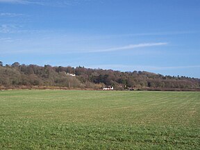
295:Westerham Heights Farm on the A233
228:area of outstanding natural beauty
25:
135:
128:
40:
27:Hill on the North Downs, England
612:"John Paul Cooper - Biography"
446:David Bathurst (2 July 2012).
214:crosses the Downs en route to
1:
531:Victorian Forts and Artillery
527:"London Mobilisation Centres"
505:Victorian Forts and Artillery
369:List of tripoints of England
638:"Westerham Hill Climb 1887"
738:
275:The artist and craftsman,
562:187 Dorking & Reigate
473:Matthews, Rupert (2010).
122:
39:
399:. Cicerone. p. 32.
62:251 m (823 ft)
420:Simon Edwardes (2001).
652:"Lettres de Speedwell"
533:. victorianforts.co.uk
507:. victorianforts.co.uk
296:
640:. CyclingRanking.com.
618:. bmagic.org.uk. 2012
476:Little Book of Surrey
294:
241:London Defence scheme
666:"Hill Climb History"
393:Muir, Jonny (2011).
102:51.2882°N 0.057188°E
347:Arthur James Wilson
343:Selwyn Francis Edge
202:. Situated between
98: /
670:Hill Climb Classic
297:
52:Highest point
459:978-0-85765-755-8
359:Geography of Kent
300:Westerham Heights
287:Westerham Heights
189:
188:
149:Betsom's Hill in
107:51.2882; 0.057188
18:Westerham Heights
16:(Redirected from
729:
686:
685:
683:
681:
662:
656:
655:
648:
642:
641:
634:
628:
627:
625:
623:
608:
602:
601:
599:
597:
582:
576:
575:
554:
543:
542:
540:
538:
523:
517:
516:
514:
512:
497:
491:
490:
470:
464:
463:
443:
434:
433:
431:
429:
417:
411:
410:
390:
315:
277:John Paul Cooper
185:
139:
138:
132:
113:
112:
110:
109:
108:
103:
99:
96:
95:
94:
91:
44:
32:
21:
737:
736:
732:
731:
730:
728:
727:
726:
717:Hills of London
692:
691:
690:
689:
679:
677:
676:on 13 June 2015
664:
663:
659:
650:
649:
645:
636:
635:
631:
621:
619:
610:
609:
605:
595:
593:
592:on 1 March 2014
584:
583:
579:
572:
558:Ordnance Survey
556:
555:
546:
536:
534:
525:
524:
520:
510:
508:
499:
498:
494:
487:
472:
471:
467:
460:
445:
444:
437:
427:
425:
419:
418:
414:
407:
392:
391:
382:
377:
364:Geology of Kent
355:
339:safety bicycles
331:penny-farthings
326:
311:
289:
281:Arts and Crafts
262:North Downs Way
257:
236:
181:
157:
156:
155:
154:
153:
147:
146:
145:
144:
140:
106:
104:
100:
97:
92:
89:
87:
85:
84:
47:
28:
23:
22:
15:
12:
11:
5:
735:
733:
725:
724:
719:
714:
709:
704:
694:
693:
688:
687:
657:
643:
629:
603:
577:
570:
544:
518:
492:
485:
465:
458:
435:
412:
405:
379:
378:
376:
373:
372:
371:
366:
361:
354:
351:
337:, and the new
325:
324:Westerham Hill
322:
308:Greater London
288:
285:
256:
253:
235:
232:
187:
186:
179:
173:
172:
163:
159:
158:
148:
142:
141:
134:
133:
127:
126:
125:
124:
123:
120:
119:
115:
114:
82:
76:
75:
70:
64:
63:
60:
54:
53:
49:
48:
45:
37:
36:
26:
24:
14:
13:
10:
9:
6:
4:
3:
2:
734:
723:
720:
718:
715:
713:
710:
708:
707:Hills of Kent
705:
703:
700:
699:
697:
675:
671:
667:
661:
658:
653:
647:
644:
639:
633:
630:
617:
613:
607:
604:
591:
587:
581:
578:
573:
571:9780319229545
567:
563:
559:
553:
551:
549:
545:
532:
528:
522:
519:
506:
502:
496:
493:
488:
486:9780752462646
482:
478:
477:
469:
466:
461:
455:
451:
450:
442:
440:
436:
423:
422:"County Tops"
416:
413:
408:
406:9781849655538
402:
398:
397:
389:
387:
385:
381:
374:
370:
367:
365:
362:
360:
357:
356:
352:
350:
348:
344:
340:
336:
332:
323:
321:
319:
314:
309:
305:
304:highest point
301:
293:
286:
284:
282:
278:
273:
271:
267:
263:
254:
252:
250:
246:
242:
233:
231:
229:
225:
221:
217:
213:
209:
205:
201:
197:
193:
192:Betsom's Hill
184:
180:
178:
174:
171:
167:
164:
160:
152:
143:Betsom's Hill
131:
121:
116:
111:
83:
81:
77:
74:
71:
69:
65:
61:
59:
55:
50:
43:
38:
35:Betsom's Hill
33:
30:
19:
678:. Retrieved
674:the original
669:
660:
646:
632:
620:. Retrieved
615:
606:
594:. Retrieved
590:the original
580:
561:
535:. Retrieved
530:
521:
509:. Retrieved
504:
495:
475:
468:
448:
426:. Retrieved
415:
395:
327:
299:
298:
274:
270:Pilgrims Way
258:
237:
191:
190:
183:TQ 4355 5633
29:
266:scarp slope
220:Botley Hill
216:Biggin Hill
200:North Downs
105: /
80:Coordinates
696:Categories
375:References
224:Kent Downs
90:51°17′18″N
73:County Top
722:Westerham
335:tricycles
255:Geography
245:casemates
208:Tatsfield
204:Westerham
166:Westerham
118:Geography
93:0°03′26″E
58:Elevation
622:17 April
596:18 April
560:(2007).
537:17 April
511:17 April
428:20 April
353:See also
318:tripoint
313:TQ436564
249:magazine
162:Location
234:History
198:on the
177:OS grid
170:England
68:Listing
680:8 June
568:
483:
456:
403:
302:, the
247:and a
226:, an
194:is a
682:2015
624:2014
598:2014
566:ISBN
539:2014
513:2014
481:ISBN
454:ISBN
430:2014
401:ISBN
212:A233
206:and
196:hill
151:Kent
306:of
698::
668:.
614:.
547:^
529:.
503:.
438:^
383:^
333:,
272:.
230:.
168:,
684:.
626:.
600:.
574:.
541:.
515:.
489:.
462:.
432:.
409:.
20:)
Text is available under the Creative Commons Attribution-ShareAlike License. Additional terms may apply.