46:
655:
125:
105:
55:
431:
448:
423:
406:
307:, 15.14% of the population were considered literate, which is more than the Zone average of 14.21%; 14.97% of children aged 7–12 were in primary school; 0.1% of the children aged 13–14 were in junior secondary school, and 0.12% of the inhabitants aged 15–18 were in senior secondary school. Concerning
274:
of
Ethiopia (CSA), this woreda has a total population of 146,104, an increase of 32.06% over the 1994 census, of whom 71,659 are men and 74,445 women; 16,525 or 11.31% are urban inhabitants. With an area of 2,360.17 square kilometers, Werie Lehe has a population density of 61.90, which is greater
328:
is missing. 79.85% of the farmers both raised crops and livestock, while 18.6% only grew crops and 1.55% only raised livestock. Land tenure in this woreda is distributed amongst 83.24% owning their land, 12.24% renting, and 4.52% in other forms of tenure.
275:
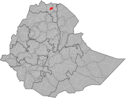
than the Zone average of 56.29 persons per square kilometer. A total of 32,591 households were counted in this woreda, resulting in an average of 4.48 persons to a household, and 31,090 housing units. The majority of the inhabitants said they practiced
319:
A sample enumeration performed by the CSA in 2001 interviewed 27,199 farmers in this woreda, who held an average of 1.09 hectares of land. Of the 29,738 hectares of private land surveyed, 82.1% was in cultivation, 0.85% pasture, 13.84% fallow, 0.22%
324:, and 2.97% was devoted to other uses. For the land under cultivation in this woreda, 73.22% was planted in cereals, 7.2% in pulses, 1.16% in oilseeds, and 0.09% in vegetables. The area planted in fruit trees was 38 hectares; the area planted in
286:
The 1994 national census reported a total population for this woreda of 110,636, of whom 54,207 were men and 56,429 were women; 4,538 or 4.1% of its population were urban dwellers. The largest ethnic group reported in Werie Lehe was the
589:
336:
announced 31 July 2009 that for the year farmers in the woreda harvested 113,044 quintals of various vegetables and fruits grown on 1,685 hectares of land, a 30% increase over the previous year.
632:
311:, about 83% of the urban houses and 13% of all houses had access to safe drinking water at the time of the census; about 2% of the urban and 2% of the total had toilet facilities.
574:
365:
590:"Central Statistical Authority of Ethiopia. Agricultural Sample Survey (AgSE2001). Report on Area and Production - Tigray Region. Version 1.1 - December 2007"
625:
250:
The area around
Nebelet is historically called Imba Seneyti. In 2020 this woreda was divided into three new woredas: Indafelasi (administrative centre:
618:
308:
665:
610:
562:
271:
1005:
358:
238:, Wkro Giyorgis and Abba Ghenzay near Nebelet. Another site of archeological interest is Henzat Gabriel, 52 kilometers southeast of
65:
242:, where local traditions claim around 160 stelae from Aksumite times are buried in and around the compound of the local church.
296:
276:
681:
351:
824:
701:
543:
395:
220:
781:
920:
811:
786:
641:
533:
Smidt W (2003) Cartography, in: Uhlig S (ed.): Encyclopaedia
Aethiopica, Wiesbaden: Harrassowitz, vol. 1: 688-691
390:
385:
216:
137:
576:
1994 Population and
Housing Census of Ethiopia: Results for Southern Nations, Nationalities and Peoples' Region
548:
45:
97:
844:
333:
304:
188:
517:
54:
892:
753:
673:
321:
948:
645:
117:
496:
933:
718:
518:"New data on ‘GZ, Son of a King, From a 3d c. AD Unvocalized Gәᶜәz Inscription (Ḥәnzat, Tәgray)"
415:
251:
212:
601:
819:
300:
292:
280:
231:
180:
259:
857:
796:
829:
953:
928:
791:
766:
738:
733:
437:
224:
999:
958:
834:
771:
686:
649:
196:
192:
142:
130:
938:
900:
706:
462:
235:
204:
279:, with 98.59% reporting that as their religion, while 1.4% of the population were
728:
457:
343:
208:
580:, Tables 2.1, 2.12, 2.19, 3.5, 3.7, 6.3, 6.11, 6.13 (accessed 30 December 2008)
882:
862:
723:
492:
255:
200:
295:
was spoken as a first language by 99.93%. 98.49% of the population practiced
80:
67:
776:
711:
288:
963:
110:
984:
968:
943:
910:
905:
872:
761:
36:
867:
852:
801:
325:
877:
696:
691:
239:
614:
347:
977:
919:
891:
843:
810:
752:
672:
544:"Local history of Ethiopia (Naader - Nyomoli 2005)"
270:Based on the 2007 national census conducted by the
166:
161:
153:
148:
136:
116:
96:
21:
602:"Farmers in Wore'leh secure over 76.4 mln Birr"
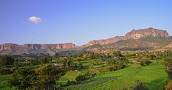
230:Local landmarks in this woreda include several
499:, "Rock-hewn Churches of the Tigre Province",
199:, Werie Lehe was bordered on the south by the
626:
359:
8:
491:Descriptions of these three can be found in
633:
619:
611:
366:
352:
344:
18:
157:2,360.17 km (911.27 sq mi)
484:
160:
147:
95:
60:
51:
42:
666:List of districts in the Tigray Region
165:
152:
135:
115:
7:
381:
14:
563:Census 2007 Tables: Tigray Region
653:
604:, ENA (accessed 1 November 2009)
446:
429:
421:
404:
123:
103:
53:
44:
565:, Tables 2.1, 2.4, 2.5 and 3.4.
297:Ethiopian Orthodox Christianity
277:Ethiopian Orthodox Christianity
1:
447:
405:
374:Places adjacent to Werie Lehe
430:
422:
524:, 29 (2014), pp. 13-25
1022:
1006:Districts of Tigray Region
592:(accessed 26 January 2009)
272:Central Statistical Agency
16:Woreda in Tigray, Ethiopia
663:
516:Yohannes Gebre Selassie,
507:(1970), pp. 264-266.
379:
223:, and on the east by the
195:of Ethiopia. Part of the
184:
61:
52:
43:
34:
225:Misraqawi (Eastern) Zone
203:which separated it from
25:
549:Nordic Africa Institute
143:Maekelay Zone (Central)
219:, on the northeast by
207:, on the southwest by
334:Ethiopian News Agency
552:. p. 5/Nebelet.
258:) and Imba Seneyti (
949:Shire Inda Selassie
340:Surrounding woredas
309:sanitary conditions
232:monolithic churches
77: /
921:North Western Zone
812:South Eastern Zone
522:Annales d'Ethiopie
215:, on the north by
167: • Total
154: • Total
993:
992:
501:Ethiopia Observer
475:
474:
470:
469:
299:, and 1.44% were
211:, on the west by
187:) was one of the
174:
173:
81:14.000°N 39.167°E
1013:
797:Saesi Tsaedaemba
658:
657:
656:
635:
628:
621:
612:
605:
599:
593:
587:
581:
578:, Vol. 1, part 1
572:
566:
560:
554:
553:
540:
534:
531:
525:
514:
508:
489:
450:
449:
433:
432:
425:
424:
408:
407:
382:
368:
361:
354:
345:
234:, which include
186:
129:
127:
126:
109:
107:
106:
92:
91:
89:
88:
87:
82:
78:
75:
74:
73:
70:
57:
48:
19:
1021:
1020:
1016:
1015:
1014:
1012:
1011:
1010:
996:
995:
994:
989:
973:
934:La'ilay Adiyabo
915:
887:
839:
830:Hintalo Wajirat
806:
748:
719:La'ilay Maychew
668:
659:
654:
652:
639:
609:
608:
600:
596:
588:
584:
573:
569:
561:
557:
542:
541:
537:
532:
528:
515:
511:
490:
486:
481:
476:
471:
434:
416:La'ilay Maychew
375:
372:
342:
317:
268:
248:
213:La'ilay Maychew
124:
122:
104:
102:
85:
83:
79:
76:
71:
68:
66:
64:
63:
39:
30:
27:
24:
17:
12:
11:
5:
1019:
1017:
1009:
1008:
998:
997:
991:
990:
988:
987:
981:
979:
975:
974:
972:
971:
966:
961:
956:
954:Tahtay Adiyabo
951:
946:
941:
936:
931:
929:Asgede Tsimbla
925:
923:
917:
916:
914:
913:
908:
903:
897:
895:
889:
888:
886:
885:
880:
875:
870:
865:
860:
855:
849:
847:
841:
840:
838:
837:
832:
827:
822:
820:Dogu'a Tembien
816:
814:
808:
807:
805:
804:
799:
794:
792:Kilte Awulaelo
789:
784:
779:
774:
769:
767:Atsbi Wenberta
764:
758:
756:
750:
749:
747:
746:
741:
739:Tanqua Millash
736:
734:Tahtay Maychew
731:
726:
721:
716:
715:
714:
704:
699:
694:
689:
684:
678:
676:
670:
669:
664:
661:
660:
640:
638:
637:
630:
623:
615:
607:
606:
594:
582:
567:
555:
535:
526:
509:
483:
482:
480:
477:
473:
472:
468:
467:
465:
460:
454:
453:
451:
444:
441:
440:
438:Misraqawi Zone
435:
420:
418:
412:
411:
409:
402:
399:
398:
393:
388:
380:
377:
376:
373:
371:
370:
363:
356:
348:
341:
338:
316:
313:
267:
264:
247:
244:
172:
171:
168:
164:
163:
159:
158:
155:
151:
150:
146:
145:
140:
134:
133:
120:
114:
113:
100:
94:
93:
86:14.000; 39.167
59:
58:
50:
49:
41:
40:
35:
32:
31:
28:
22:
15:
13:
10:
9:
6:
4:
3:
2:
1018:
1007:
1004:
1003:
1001:
986:
983:
982:
980:
978:Special Zones
976:
970:
967:
965:
962:
960:
959:Tahtay Koraro
957:
955:
952:
950:
947:
945:
942:
940:
937:
935:
932:
930:
927:
926:
924:
922:
918:
912:
909:
907:
904:
902:
899:
898:
896:
894:
890:
884:
881:
879:
876:
874:
871:
869:
866:
864:
861:
859:
856:
854:
851:
850:
848:
846:
845:Southern Zone
842:
836:
835:Saharti Samre
833:
831:
828:
826:
823:
821:
818:
817:
815:
813:
809:
803:
800:
798:
795:
793:
790:
788:
785:
783:
780:
778:
775:
773:
772:Ganta Afeshum
770:
768:
765:
763:
760:
759:
757:
755:
751:
745:
742:
740:
737:
735:
732:
730:
727:
725:
722:
720:
717:
713:
710:
709:
708:
705:
703:
700:
698:
695:
693:
690:
688:
685:
683:
680:
679:
677:
675:
671:
667:
662:
651:
650:Tigray Region
647:
643:
636:
631:
629:
624:
622:
617:
616:
613:
603:
598:
595:
591:
586:
583:
579:
577:
571:
568:
564:
559:
556:
551:
550:
545:
539:
536:
530:
527:
523:
519:
513:
510:
506:
502:
498:
494:
488:
485:
478:
466:
464:
461:
459:
456:
455:
452:
445:
443:
442:
439:
436:
428:
419:
417:
414:
413:
410:
403:
401:
400:
397:
394:
392:
389:
387:
384:
383:
378:
369:
364:
362:
357:
355:
350:
349:
346:
339:
337:
335:
330:
327:
323:
314:
312:
310:
306:
303:. Concerning
302:
298:
294:
290:
284:
282:
278:
273:
265:
263:
261:
257:
253:
245:
243:
241:
237:
233:
228:
226:
222:
218:
214:
210:
206:
202:
198:
197:Maekelay Zone
194:
193:Tigray Region
190:
182:
178:
169:
156:
144:
141:
139:
132:
121:
119:
112:
101:
99:
90:
62:Coordinates:
56:
47:
38:
33:
20:
939:Medebay Zana
901:Kafta Humera
893:Western Zone
754:Eastern Zone
743:
707:Kola Tembien
674:Central Zone
597:
585:
575:
570:
558:
547:
538:
529:
521:
512:
504:
500:
497:David Buxton
487:
463:Kola Tembien
426:
331:
318:
285:
269:
266:Demographics
249:
236:Wkro Mariyam
229:
205:Kola Tembien
176:
175:
729:Naeder Adet
458:Naeder Adet
315:Agriculture
254:), Weri'i (
209:Naeder Adet
84: /
29:Weri'i Lehi
883:Raya Azebo
863:Endamekoni
744:Werie Lehe
724:Mereb Lehe
493:Ruth Plant
427:Werie Lehe
256:Edaga Arbi
252:Maykinetal
201:Wari River
177:Werie Lehe
162:Population
23:Werie Leke
777:Gulomahda
712:Abiy Addi
692:Adwa Town
305:education
291:(99.9%).
1000:Category
964:Tselemti
682:Abergele
322:woodland
293:Tigrinya
289:Tigrayan
181:Tigrinya
111:Ethiopia
985:Mekelle
969:Tsimbla
944:Sheraro
911:Welkait
906:Tsegede
873:Maychew
858:Alamata
825:Enderta
762:Adigrat
702:Enticho
648:of the
646:Woredas
396:Enticho
260:Nebelet
246:History
221:Enticho
191:in the
189:woredas
170:146,104
98:Country
72:39°10′E
69:14°00′N
782:Hawzen
301:Muslim
281:Muslim
185:ወርዒ ለኸ
131:Tigray
128:
118:Region
108:
37:Woreda
26:ወርዒ ለኸ
868:Korem
853:Alaje
802:Wukro
642:Zones
495:with
479:Notes
326:gesho
878:Ofla
787:Irob
697:Axum
687:Adwa
644:and
391:Adwa
386:Adwa
332:The
240:Adwa
217:Adwa
149:Area
138:Zone
262:).
1002::
546:.
520:,
505:13
503:,
283:.
227:.
183::
634:e
627:t
620:v
367:e
360:t
353:v
179:(
Text is available under the Creative Commons Attribution-ShareAlike License. Additional terms may apply.