593:
577:
45:
29:
724:
Dunkard Fork, also known historically as "Crow Creek," is formed in
Pennsylvania by the confluence of the North Fork Dunkard Fork and the South Fork Dunkard Fork in Richhill Township in Greene County, and flows northwestwardly into Marshall County. Its north and south forks each flow northwestwardly
811:
on the creek in the Elm Grove neighborhood of
Wheeling, downstream of the mouth of Little Wheeling Creek and 7.8 miles (12.6 km) upstream of the creek's mouth. Between 1941 and 2005, the annual mean flow of the creek at the gauge was
820:). The creek's highest flow during the period was estimated at 22,300 ft³/s (632 m³/s) on September 17, 2004. The lowest recorded flow was 0.1 ft³/s (0 m³/s) on October 7, 1963, and on two days in September 1964.
776:) parallels Little Wheeling Creek through eastern Ohio County, and follows Wheeling Creek for part of its route through the city of Wheeling; the creek is also paralleled for five miles (8.0 km) in Wheeling by a
1118:"Leaden Plate Buried at Wheeling Creek > Research | Ohio County Public Library | Ohio County Public Library | Wheeling West Virginia | Ohio County WV | Wheeling WV History |"
828:
Wheeling Creek is a popular fishing destination to those close to it. There are many entry points located alongside the
Wheeling Heritage Trail System. There are a variety of fish species including
783:
According to the West
Virginia Department of Environmental Protection, of the 141 square miles (370 km) drained by Wheeling Creek in West Virginia, approximately 67% is
1369:
710:
1379:
1374:
1051:
726:
734:
698:
392:
1364:
652:
869:
668:
1236:
1212:
1188:
1164:
992:
961:
911:
612:
585:
568:
1063:
311:
225:
139:
718:
714:
1344:
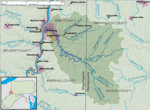
1148:
1101:
765:, which rises in West Finley Township in Greene County, Pennsylvania, and flows generally westwardly into southeastern Ohio County.
1359:
697:
Counties, and flows west-southwestwardly along that boundary into
Marshall County. Enlow Fork defines the northern boundaries of
1285:
1024:
804:
706:
694:
203:
121:
773:
674:
581:
289:
83:
803:
At its mouth, the estimated mean annual flow volume of
Wheeling Creek is 373.5 cubic feet per second (10.58 m/s). The
753:, which rises in Ohio County just west of the Pennsylvania state line and flows southwestwardly through the communities of
889:
874:
754:
741:
From the confluence of the
Dunkard and Enlow forks, Wheeling Creek flows northwestwardly into the city of Wheeling in
702:
690:
207:
117:
1281:
758:
742:
730:
293:
87:
746:
1240:
1216:
1192:
1168:
996:
965:
915:
817:
636:
374:
34:
1339:
1334:
813:
644:
562:
841:
1028:
689:
Enlow Fork, also known historically as "Enslow Fork," rises in
Pennsylvania on the boundary of
1144:
1097:
632:
624:
502:
1193:"Geographic Names Information System entry for South Fork Dunkard Fork (Feature ID #1198127)"
1169:"Geographic Names Information System entry for North Fork Dunkard Fork (Feature ID #1198104)"
1055:
592:
576:
1241:"Geographic Names Information System entry for Middle Wheeling Creek (Feature ID #1181059)"
1217:"Geographic Names Information System entry for Little Wheeling Creek (Feature ID #1542252)"
1117:
833:
616:
506:
44:
1353:
853:
837:
769:
659:, as was inscribed on the lead plate buried at the mouth by the Ohio River in 1749.
378:
297:
73:
63:
997:"Geographic Names Information System entry for Wheeling Creek (Feature ID #1548996)"
941:
808:
620:
211:
125:
966:"Geographic Names Information System entry for Dunkard Fork (Feature ID #1173610)"
916:"Geographic Names Information System entry for Enlow Fork (Feature ID #1174270)"
879:
857:
829:
788:
357:
596:
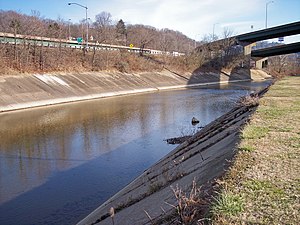
Wheeling Creek as viewed upstream from Main Street in downtown
Wheeling in 2006
1310:
1020:
792:
777:
628:
608:
498:
362:
407:
394:
326:
313:
240:
227:
154:
141:
604:
28:
627:, draining an area of approximately 300 square miles (780 km) on the
849:
1289:
1260:
1140:
1093:
845:
784:
733:, where it is dammed to form a lake; and the South Fork rises in
945:
640:
1340:
USGS real-time water data for
Dunkard Fork near Majorsville
709:
Townships in Greene County; and the southern boundaries of
1335:
USGS real-time water data for Wheeling Creek at Elm Grove
623:. Via the Ohio River, it is part of the watershed of the
580:
Wheeling Creek as viewed at the junction of Interstates
1280:
West Virginia Department of Environmental Protection.
1021:"Water Resources Data, West Virginia, Water Year 2005"
544:
520:
512:
494:
489:
471:
461:
453:
441:
433:
423:
384:
368:
356:
342:
303:
282:
274:
256:
217:
196:
188:
170:
131:
110:
102:
93:
79:
69:
59:
54:
21:
761:. In Triadelphia, Little Wheeling Creek collects
852:. Wheeling Creek is also regularly stocked with
780:as part of the Wheeling Heritage Trail network.
725:into Richhill Township; the North Fork rises in
1313:. West Virginia Division of Natural Resources
1052:United States Environmental Protection Agency
8:
677:, by the confluence of streams known as the
1131:
1129:
1127:
1084:
1082:
1080:
635:. It flows into the Ohio River in downtown
1029:Upper Ohio and Little Kanawha River Basins
477:373.5 cu ft/s (10.58 m/s) (
1046:
1044:
673:Wheeling Creek is formed in northeastern
647:on the opposite bank. A variant name is
202:Confluence of North Fork and South Fork,
49:A map of Wheeling Creek and its watershed
1370:Rivers of Marshall County, West Virginia
591:
575:
445:300 sq mi (780 km)approx.
956:
954:
906:
904:
900:
655:, the native name of the stream is the
1014:
1012:
987:
985:
983:
981:
749:neighborhood of Wheeling, it collects
18:
948:coordinates. Retrieved on 2007-06-14.
870:List of tributaries of Wheeling Creek
669:List of tributaries of Wheeling Creek
611:, 25 miles (40 km) long, in the
16:River in West Virginia, United States
7:
1380:Geography of Wheeling, West Virginia
1375:Rivers of Ohio County, West Virginia
937:
935:
933:
931:
1237:Geographic Names Information System
1213:Geographic Names Information System
1189:Geographic Names Information System
1165:Geographic Names Information System
1090:West Virginia Atlas & Gazetteer
993:Geographic Names Information System
962:Geographic Names Information System
912:Geographic Names Information System
884:archeological site along Enlow Fork
653:Pierre Joseph Céloron de Blainville
651:. According to the French explorer
613:northern panhandle of West Virginia
1137:Pennsylvania Atlas & Gazetteer
1056:"Watershed Report: Wheeling Creek"
14:
787:; approximately 27% is used for
43:
27:
1066:from the original on 2021-07-05
1025:United States Geological Survey
805:United States Geological Survey
721:townships in Washington County.
675:Marshall County, West Virginia
386: • coordinates
305: • coordinates
219: • coordinates
133: • coordinates
1:
1365:Tributaries of the Ohio River
94:Physical characteristics
1143:. 2003. pp. 70, 84–85.
890:List of West Virginia rivers
619:extending into southwestern
425: • elevation
344: • elevation
258: • elevation
172: • elevation
1019:Ward, S. M.; G. R. Crosby.
875:Elm Grove Stone Arch Bridge
463: • location
370: • location
284: • location
198: • location
112: • location
1396:
791:; and approximately 5% is
731:Ryerson Station State Park
666:
473: • average
176:1,339 ft (408 m)
1311:"Trout Stocking Schedule"
1282:"Watershed Atlas Project"
1261:"Wheeling Heritage Trail"
485:
449:
352:
270:
266:
184:
180:
98:
42:
26:
546: • right
429:630 ft (190 m)
348:829 ft (253 m)
262:927 ft (283 m)
1360:Rivers of West Virginia
522: • left
437:25 mi (40 km)
597:
589:
844:, various species of
814:cubic feet per second
763:Middle Wheeling Creek
751:Little Wheeling Creek
639:, just downstream of
595:
579:
563:Little Wheeling Creek
408:40.06389°N 80.72500°W
327:39.95417°N 80.52861°W
241:39.89250°N 80.47806°W
155:40.00222°N 80.34083°W
1345:stocking information
1096:. 1997. p. 21.
588:in Wheeling in 2006
490:Basin features
413:40.06389; -80.72500
404: /
332:39.95417; -80.52861
323: /
246:39.89250; -80.47806
237: /
160:40.00222; -80.34083
151: /
1286:Upper Ohio River 2
729:and flows through
649:Big Wheeling Creek
598:
590:
33:Wheeling Creek in
1139:. Yarmouth, Me.:
1092:. Yarmouth, Me.:
1060:watersgeo.epa.gov
633:Allegheny Plateau
625:Mississippi River
574:
573:
534:Bald Eagle Hollow
503:Mississippi River
275:Source confluence
204:Richhill Township
1387:
1323:
1322:
1320:
1318:
1307:
1301:
1300:
1298:
1297:
1288:. Archived from
1277:
1271:
1270:
1268:
1267:
1257:
1251:
1250:
1248:
1247:
1233:
1227:
1226:
1224:
1223:
1209:
1203:
1202:
1200:
1199:
1185:
1179:
1178:
1176:
1175:
1161:
1155:
1154:
1133:
1122:
1121:
1114:
1108:
1107:
1086:
1075:
1074:
1072:
1071:
1048:
1039:
1038:
1036:
1035:
1016:
1007:
1006:
1004:
1003:
989:
976:
975:
973:
972:
958:
949:
939:
926:
925:
923:
922:
908:
727:Jackson Township
657:Kanououara River
547:
538:Seabright Hollow
523:
474:
464:
419:
418:
416:
415:
414:
409:
405:
402:
401:
400:
397:
345:
338:
337:
335:
334:
333:
328:
324:
321:
320:
319:
316:
306:
285:
259:
252:
251:
249:
248:
247:
242:
238:
235:
234:
233:
230:
220:
199:
173:
166:
165:
163:
162:
161:
156:
152:
149:
148:
147:
144:
134:
113:
47:
31:
19:
1395:
1394:
1390:
1389:
1388:
1386:
1385:
1384:
1350:
1349:
1331:
1326:
1316:
1314:
1309:
1308:
1304:
1295:
1293:
1279:
1278:
1274:
1265:
1263:
1259:
1258:
1254:
1245:
1243:
1235:
1234:
1230:
1221:
1219:
1211:
1210:
1206:
1197:
1195:
1187:
1186:
1182:
1173:
1171:
1163:
1162:
1158:
1151:
1135:
1134:
1125:
1116:
1115:
1111:
1104:
1088:
1087:
1078:
1069:
1067:
1050:
1049:
1042:
1033:
1031:
1018:
1017:
1010:
1001:
999:
991:
990:
979:
970:
968:
960:
959:
952:
940:
929:
920:
918:
910:
909:
902:
898:
866:
842:hognose suckers
834:smallmouth bass
826:
801:
735:Aleppo Township
671:
665:
631:portion of the
567:
565:
561:
559:
557:
555:
553:
551:
545:
539:
537:
535:
533:
531:
529:
527:
521:
472:
462:
426:
412:
410:
406:
403:
398:
395:
393:
391:
390:
387:
371:
343:
331:
329:
325:
322:
317:
314:
312:
310:
309:
304:
290:Marshall County
283:
257:
245:
243:
239:
236:
231:
228:
226:
224:
223:
218:
197:
171:
159:
157:
153:
150:
145:
142:
140:
138:
137:
132:
111:
50:
38:
17:
12:
11:
5:
1393:
1391:
1383:
1382:
1377:
1372:
1367:
1362:
1352:
1351:
1348:
1347:
1342:
1337:
1330:
1329:External links
1327:
1325:
1324:
1302:
1272:
1252:
1228:
1204:
1180:
1156:
1149:
1123:
1109:
1102:
1076:
1040:
1008:
977:
950:
944:elevation for
927:
899:
897:
894:
893:
892:
887:
877:
872:
865:
862:
825:
822:
800:
797:
739:
738:
722:
664:
661:
645:Wheeling Creek
601:Wheeling Creek
572:
571:
558:Grandstaff Run
556:Cricket Hollow
548:
542:
541:
524:
518:
517:
514:
510:
509:
507:Gulf of Mexico
496:
492:
491:
487:
486:
483:
482:
475:
469:
468:
465:
459:
458:
455:
451:
450:
447:
446:
443:
439:
438:
435:
431:
430:
427:
424:
421:
420:
388:
385:
382:
381:
372:
369:
366:
365:
360:
354:
353:
350:
349:
346:
340:
339:
307:
301:
300:
286:
280:
279:
276:
272:
271:
268:
267:
264:
263:
260:
254:
253:
221:
215:
214:
200:
194:
193:
190:
186:
185:
182:
181:
178:
177:
174:
168:
167:
135:
129:
128:
114:
108:
107:
104:
100:
99:
96:
95:
91:
90:
81:
77:
76:
71:
67:
66:
61:
57:
56:
52:
51:
48:
40:
39:
32:
24:
23:
22:Wheeling Creek
15:
13:
10:
9:
6:
4:
3:
2:
1392:
1381:
1378:
1376:
1373:
1371:
1368:
1366:
1363:
1361:
1358:
1357:
1355:
1346:
1343:
1341:
1338:
1336:
1333:
1332:
1328:
1312:
1306:
1303:
1292:on 2005-04-04
1291:
1287:
1283:
1276:
1273:
1262:
1256:
1253:
1242:
1238:
1232:
1229:
1218:
1214:
1208:
1205:
1194:
1190:
1184:
1181:
1170:
1166:
1160:
1157:
1152:
1150:0-89933-280-3
1146:
1142:
1138:
1132:
1130:
1128:
1124:
1119:
1113:
1110:
1105:
1103:0-89933-246-3
1099:
1095:
1091:
1085:
1083:
1081:
1077:
1065:
1061:
1057:
1053:
1047:
1045:
1041:
1030:
1026:
1022:
1015:
1013:
1009:
998:
994:
988:
986:
984:
982:
978:
967:
963:
957:
955:
951:
947:
943:
938:
936:
934:
932:
928:
917:
913:
907:
905:
901:
895:
891:
888:
885:
881:
878:
876:
873:
871:
868:
867:
863:
861:
859:
855:
854:rainbow trout
851:
847:
843:
839:
835:
831:
823:
821:
819:
815:
810:
806:
798:
796:
794:
790:
786:
781:
779:
775:
774:U.S. Route 40
771:
770:National Road
766:
764:
760:
756:
752:
748:
744:
736:
732:
728:
723:
720:
716:
712:
708:
704:
700:
696:
692:
688:
687:
686:
684:
680:
676:
670:
662:
660:
658:
654:
650:
646:
642:
638:
634:
630:
626:
622:
618:
614:
610:
606:
602:
594:
587:
583:
578:
570:
564:
549:
543:
536:Hollidays Run
525:
519:
515:
511:
508:
504:
500:
497:
493:
488:
484:
480:
476:
470:
466:
460:
456:
452:
448:
444:
440:
436:
432:
428:
422:
417:
389:
383:
380:
379:West Virginia
376:
373:
367:
364:
361:
359:
355:
351:
347:
341:
336:
308:
302:
299:
298:West Virginia
295:
291:
288:northeastern
287:
281:
277:
273:
269:
265:
261:
255:
250:
222:
216:
213:
209:
208:Greene County
205:
201:
195:
191:
187:
183:
179:
175:
169:
164:
136:
130:
127:
123:
119:
115:
109:
105:
101:
97:
92:
89:
85:
82:
78:
75:
74:West Virginia
72:
68:
65:
64:United States
62:
58:
53:
46:
41:
36:
30:
25:
20:
1315:. Retrieved
1305:
1294:. Retrieved
1290:the original
1275:
1264:. Retrieved
1255:
1244:. Retrieved
1231:
1220:. Retrieved
1207:
1196:. Retrieved
1183:
1172:. Retrieved
1159:
1136:
1112:
1089:
1068:. Retrieved
1059:
1032:. Retrieved
1000:. Retrieved
969:. Retrieved
942:Google Earth
919:. Retrieved
883:
827:
809:stream gauge
802:
782:
767:
762:
755:Valley Grove
750:
740:
683:Dunkard Fork
682:
678:
672:
656:
648:
621:Pennsylvania
600:
599:
526:Dunkard Fork
478:
212:Pennsylvania
192:Dunkard Fork
126:Pennsylvania
116:boundary of
1284:. pp.
1027:. pp.
880:Fisher site
858:brown trout
830:muskellunge
807:operates a
789:agriculture
759:Triadelphia
743:Ohio County
719:West Finley
715:East Finley
629:unglaciated
513:Tributaries
495:Progression
411: /
330: /
294:Majorsville
244: /
158: /
1354:Categories
1317:13 October
1296:2007-03-17
1266:2007-03-17
1246:2007-03-17
1222:2007-03-17
1198:2007-03-17
1174:2007-03-17
1070:2021-07-05
1034:2007-06-14
1002:2007-03-17
971:2007-03-17
921:2007-03-17
896:References
816:(9.7
778:rail trail
695:Washington
679:Enlow Fork
667:See also:
609:Ohio River
566:Carter Run
552:Turkey Run
550:Enlow Fork
499:Ohio River
442:Basin size
399:80°43′30″W
396:40°03′50″N
363:Ohio River
318:80°31′43″W
315:39°57′15″N
232:80°28′41″W
229:39°53′33″N
189:2nd source
146:80°20′27″W
143:40°00′08″N
124:Counties,
122:Washington
106:Enlow Fork
812:343
799:Discharge
747:Elm Grove
745:. In the
663:Geography
617:watershed
615:, with a
605:tributary
560:Britt Run
554:Bruce Run
540:Jakes Run
532:Burch Run
530:Stull Run
454:Discharge
1064:Archived
864:See also
850:bluegill
785:forested
707:Richhill
681:and the
637:Wheeling
569:Long Run
528:Wolf Run
479:estimate
375:Wheeling
84:Marshall
80:Counties
55:Location
35:Wheeling
1141:DeLorme
1094:DeLorme
846:catfish
838:sunfish
824:Fishing
607:of the
60:Country
37:in 2006
1147:
1100:
848:, and
717:, and
711:Morris
705:, and
699:Morris
691:Greene
516:
457:
434:Length
278:
118:Greene
103:Source
793:urban
603:is a
467:mouth
358:Mouth
292:near
70:State
1319:2013
1145:ISBN
1098:ISBN
946:GNIS
856:and
818:m³/s
768:The
757:and
703:Gray
693:and
641:Ohio
584:and
120:and
88:Ohio
643:'s
586:470
1356::
1239:.
1215:.
1191:.
1167:.
1126:^
1079:^
1062:.
1058:.
1054:.
1043:^
1023:.
1011:^
995:.
980:^
964:.
953:^
930:^
914:.
903:^
882:—
860:.
840:,
836:,
832:,
795:.
713:,
701:,
685::
582:70
505:→
501:→
377:,
296:,
210:,
206:,
86:,
1321:.
1299:.
1269:.
1249:.
1225:.
1201:.
1177:.
1153:.
1120:.
1106:.
1073:.
1037:.
1005:.
974:.
924:.
886:.
772:(
737:.
481:)
Text is available under the Creative Commons Attribution-ShareAlike License. Additional terms may apply.