501:
40:
217:
typically 50 by 50 metres. In the 1960s, the west side was developed with smaller lots but mostly large custom homes. At the same time, many lots in the east side of the neighbourhood were subdivided and infill housing was built. Subdivisions have continued through to today, giving
Whitehaven a very eclectic housing character. Whitehaven Crescent was built up throughout the mid 1960s as the area's namesake.
442:
459:
434:
417:
216:
Whitehaven was developed on the lands of Fox farm starting in the 1950s. The Fox farm homestead can still be found on Fox
Crescent in the north part of the neighbourhood with its windmill tower now shaded by a large tree. Originally the east side of the neighbourhood was subdivided into large lots,
228:. In the 1960s there was also a public primary school which operated until 1999 called Whitehaven Public School. It was closed for a few years after much dispute and then was reopened and expanded as a
243:
and
Lincoln Fields shopping malls are within walking distance of the neighbourhood. Both shopping centres are serviced extensively by OC Transpo with Lincoln Fields being serviced by the
372:
546:
244:
321:
365:
565:
512:
106:
358:
221:
240:
539:
93:
274:
426:
392:
220:
The south west side of the neighbourhood contains a large park with a playground, with schools including
570:
225:
210:
39:
532:
248:
163:
119:
65:
500:
288:
396:
292:
206:
153:
516:
401:
124:
98:
254:
229:
191:
350:
312:
Population calculated by combining
Dissemination Areas 35061178, 35061192, and 35061285
253:
Whitehaven is also connected locally to a network of bike paths with direct access to
199:
559:
111:
478:
468:
473:
448:
406:
236:
203:
336:
323:
170:
149:
144:
187:
213:
to the south. As of 2021, the population of the neighbourhood is 2323.
70:
508:
195:
80:
354:
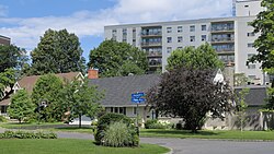
198:, about 10 kilometres west of downtown. It is bounded by
520:
160:
143:
135:
130:
117:
104:
91:
86:
76:
64:
56:
23:
202:to the north, Woodroffe Avenue to the east, the
235:Whitehaven has plenty of transportation links,
540:
366:
8:
547:
533:
373:
359:
351:
20:
232:primary school, called Terre des Jeunes.
18:Neighbourhood in Ottawa, Ontario, Canada
266:
142:
129:
85:
55:
48:
36:
381:Places adjacent to Whitehaven, Ottawa
159:
134:
116:
103:
90:
75:
63:
7:
497:
495:
388:
519:. You can help Knowledge (XXG) by
14:
499:
457:
440:
432:
415:
186:) is a neighbourhood located in
38:
245:Lincoln Fields Transit Station
1:
458:
416:
441:
433:
222:D. Roy Kennedy Public School
587:
494:
239:and shopping centres. The
507:This article relating to
386:
49:
37:
30:
566:Neighbourhoods in Ottawa
513:National Capital Region
427:Queensway Terrace North
289:"Census of Population"
51:Location of Whitehaven
337:45.36389°N 75.77500°W
226:Woodroffe High School
162: • Summer (
342:45.36389; -75.77500
333: /
190:in the west end of
438:Whitehaven, Ottawa
136: • Total
528:
527:
489:
488:
484:
483:
293:Statistics Canada
177:
176:
578:
549:
542:
535:
511:and to Canada's
503:
496:
461:
460:
444:
443:
436:
435:
419:
418:
389:
375:
368:
361:
352:
348:
347:
345:
344:
343:
338:
334:
331:
330:
329:
326:
313:
310:
304:
303:
301:
299:
285:
279:
278:
275:"Baywardlive.ca"
271:
209:to the west and
167:
125:Theresa Kavanagh
99:Anita Vandenbeld
42:
21:
586:
585:
581:
580:
579:
577:
576:
575:
556:
555:
554:
553:
492:
490:
485:
445:
382:
379:
341:
339:
335:
332:
327:
324:
322:
320:
319:
317:
316:
311:
307:
297:
295:
287:
286:
282:
273:
272:
268:
263:
255:downtown Ottawa
192:Ottawa, Ontario
161:
52:
45:
44:Rosewood Avenue
33:
26:
19:
12:
11:
5:
584:
582:
574:
573:
568:
558:
557:
552:
551:
544:
537:
529:
526:
525:
504:
487:
486:
482:
481:
476:
471:
465:
464:
462:
455:
452:
451:
446:
431:
429:
423:
422:
420:
413:
410:
409:
404:
399:
393:Lincoln Fields
387:
384:
383:
380:
378:
377:
370:
363:
355:
315:
314:
305:
280:
265:
264:
262:
259:
200:Carling Avenue
182:(also spelled
175:
174:
168:
158:
157:
147:
141:
140:
137:
133:
132:
128:
127:
122:
115:
114:
109:
102:
101:
96:
89:
88:
84:
83:
78:
74:
73:
68:
62:
61:
58:
54:
53:
50:
47:
46:
43:
35:
34:
31:
28:
27:
24:
17:
13:
10:
9:
6:
4:
3:
2:
583:
572:
569:
567:
564:
563:
561:
550:
545:
543:
538:
536:
531:
530:
524:
522:
518:
514:
510:
505:
502:
498:
493:
480:
477:
475:
472:
470:
467:
466:
463:
456:
454:
453:
450:
447:
439:
430:
428:
425:
424:
421:
414:
412:
411:
408:
405:
403:
400:
398:
394:
391:
390:
385:
376:
371:
369:
364:
362:
357:
356:
353:
349:
346:
309:
306:
294:
290:
284:
281:
276:
270:
267:
260:
258:
256:
251:
250:
246:
242:
238:
233:
231:
227:
223:
218:
214:
212:
208:
205:
201:
197:
193:
189:
185:
181:
172:
169:
165:
155:
151:
148:
146:
138:
126:
123:
121:
118: •
113:
112:Chandra Pasma
110:
108:
105: •
100:
97:
95:
92: •
82:
79:
72:
69:
67:
59:
41:
32:Neighbourhood
29:
22:
16:
571:Ottawa stubs
521:expanding it
506:
491:
479:Bel-Air Park
469:Parkway Park
437:
318:
308:
296:. Retrieved
283:
269:
252:
234:
219:
215:
183:
179:
178:
15:
474:Kenson Park
449:Glabar Park
407:Carlingwood
340: /
241:Carlingwood
237:green space
211:Highway 417
184:White Haven
120:Councillors
560:Categories
328:75°46′30″W
325:45°21′50″N
261:References
249:Transitway
207:Transitway
204:OC Transpo
180:Whitehaven
131:Population
87:Government
25:Whitehaven
402:Wood Park
397:Britannia
145:Time zone
188:Bay Ward
66:Province
298:July 1,
247:on the
71:Ontario
57:Country
509:Ottawa
230:French
196:Canada
81:Ottawa
60:Canada
515:is a
173:(EDT)
171:UTC−4
150:UTC−5
139:2,323
517:stub
300:2024
224:and
107:MPPs
77:City
164:DST
154:EST
94:MPs
562::
395:,
291:.
257:.
194:,
548:e
541:t
534:v
523:.
374:e
367:t
360:v
302:.
277:.
166:)
156:)
152:(
Text is available under the Creative Commons Attribution-ShareAlike License. Additional terms may apply.