40:
179:
214:, almost a mile north of the factory, and the neighborhood center began to shift there. By 1900 the electric trolley line from New Haven reached Whitneyville, leading to the subdivision of surrounding land for residential development. The neighborhood street network was substantially complete by 1927. Houses continued to be built well into the twentieth century, notably several distinctive modern homes on Deepwood Drive, and the last house in which playwright
202:
321:, a private, coeducational school for prekindergarten to grade 12, and the Children's Center of Hamden, a residential facility for children and teenagers with learning disabilities and other challenges. The central offices of the Hamden public schools are located in the former Putnam Avenue School building.
336:
There are two town parks in the neighborhood. DeNicola Park has a playground, multisport field, and basketball courts. Villano Park has a playground, splash pad, multisport field, and basketball and tennis courts. The adjoining
Rochford Field has baseball and softball fields used by Albertus Magnus.
209:
In 1860 Whitney's son, Eli
Whitney Jr., completely rebuilt the factory and increased the height of the mill dam. This provided more water power and created Lake Whitney, the first municipal water supply for New Haven. He was also a financial supporter of
39:
143:. Today it is primarily residential, with a mixture of single-family homes and small apartment and condominium buildings. There is some commercial development centered around the intersection of
211:
288:
Whitney Avenue extends north and south through the neighborhood with Putnam Avenue extending to the west from
Whitney. The nearest expressway interchanges are on the
205:
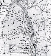
As shown in this map from 1868, Whitneyville originally centered at
Whitney's armory. It later shifted to the Congregational Church near the center of the map.
265:
556:
405:
273:
227:
444:
302:
operates the 228 and 229 bus routes on
Whitney Avenue and the 234 route on Putnam Avenue and several other neighborhood streets.
150:
There are no officially established boundaries for the neighborhood. One map has it bounded on the north by the northern part of
163:
318:
178:
166:. The census tract with GEOID 09009165400, corresponding closely to these boundaries, had a population of 5,112, as of the
80:
488:
551:
151:
167:
159:
50:
325:
245:
162:, on the south by the New Haven city line, and on the west by parts of Newhall Street, Putnam Avenue, and
140:
74:
474:
289:
369:
306:
120:
92:
460:
269:
250:
440:
401:
62:
239:
194:, with water power from the Mill River, as the site of his gun factory in 1798, and built a
136:
116:
87:
276:
district, with a small western portion in the 94th. It is in the 5th district of the town
264:
The Town of Hamden provides all municipal services for the neighborhood. It is located in
215:
201:
155:
195:
186:
Several grist mills were established in what is now the neighborhood as early as 1640.
144:
545:
293:
234:
55:
309:, extends along the western edge of Whitneyville with an entrance on Putnam Avenue.
277:
112:
272:
district, with a small western portion in the 17th, and most of it is in the 91st
187:
132:
124:
67:
299:
191:
135:'s gun factory. Around the turn of the twentieth century, it evolved into a
128:
198:
for unmarried workers nearby, establishing the village of
Whitneyville.
505:
280:. It is served by the Whitneyville post office with ZIP code 06517.
519:
200:
177:
44:
536:
226:
These locations in the neighborhood are listed on the
18:
Neighborhood in New Haven, Connecticut, United States
317:Educational facilities in the neighborhood include
437:
98:
86:
73:
61:
49:
23:
422:Map showing streets in a portion of Town of Hamden
127:. It started in the early nineteenth century as a
384:The History of Hamden, Connecticut, 1786-1959.
370:"Neighborhood Scout overview of Whitneyville"
8:
328:in New Haven extends into the neighborhood.
268:. Most of the neighborhood is in the 11th
20:
439:. Yale University Press. pp. 37–38.
305:Farmington Canal Greenway, a segment of
266:Connecticut's 3rd congressional district
489:"CT Transit New Haven local system map"
346:
97:
48:
36:
398:Hamden: Tales from the Sleeping Giant
85:
72:
60:
7:
228:National Register of Historic Places
115:in the southeastern portion of the
356:Hamden: Our Architectural Heritage
255:Whitneyville Congregational Church
212:Whitneyville Congregational Church
14:
324:A small portion of the campus of
154:and Waite Street, on the east by
38:
435:Brown, Elizabeth Mills (1976).
164:Farmington Canal Heritage Trail
537:Whitneyville Civic Association
461:"Thornton Wilder House (1929)"
319:Hamden Hall Country Day School
1:
506:"Children's Center of Hamden"
400:. History Press. p. 21.
557:Neighborhoods in Connecticut
358:. Whitney Press. p. 23.
190:chose a mill at the base of
354:Becker, Martha May (1986).
573:
424:. Proctor & Way. 1927.
37:
30:
396:Lehman, Eric D. (2010).
382:Hartley, Rachel (1959).
292:(Route 15) in Hamden or
326:Albertus Magnus College
251:Eli Whitney Gun Factory
246:Pistol Factory Dwelling
475:"Hamden district maps"
206:
183:
204:
182:Whitneyville in 1827.
181:
386:Map in frontispiece.
290:Wilbur Cross Parkway
147:and Putnam avenues.
552:Hamden, Connecticut
520:"Hamden town parks"
307:East Coast Greenway
278:legislative council
207:
184:
77:(non-governmental)
407:978-1-59629-835-4
156:Hartford Turnpike
106:
105:
564:
524:
523:
516:
510:
509:
502:
496:
495:
493:
485:
479:
478:
471:
465:
464:
457:
451:
450:
432:
426:
425:
418:
412:
411:
393:
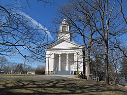
387:
380:
374:
373:
366:
360:
359:
351:
240:Farmington Canal
42:
21:
572:
571:
567:
566:
565:
563:
562:
561:
542:
541:
533:
528:
527:
518:
517:
513:
504:
503:
499:
491:
487:
486:
482:
473:
472:
468:
459:
458:
454:
447:
434:
433:
429:
420:
419:
415:
408:
395:
394:
390:
381:
377:
368:
367:
363:
353:
352:
348:
343:
334:
315:
286:
262:
224:
216:Thornton Wilder
176:
131:for workers in
45:
33:
26:
19:
12:
11:
5:
570:
568:
560:
559:
554:
544:
543:
540:
539:
532:
531:External links
529:
526:
525:
511:
497:
480:
466:
452:
445:
427:
413:
406:
388:
375:
361:
345:
344:
342:
339:
333:
330:
314:
311:
296:in New Haven.
285:
284:Transportation
282:
261:
258:
257:
256:
253:
248:
243:
237:
223:
222:Historic sites
220:
196:boarding house
175:
172:
137:trolley suburb
104:
103:
100:
96:
95:
90:
84:
83:
78:
71:
70:
65:
59:
58:
53:
47:
46:
43:
35:
34:
31:
28:
27:
24:
17:
13:
10:
9:
6:
4:
3:
2:
569:
558:
555:
553:
550:
549:
547:
538:
535:
534:
530:
521:
515:
512:
507:
501:
498:
490:
484:
481:
476:
470:
467:
462:
456:
453:
448:
446:0-300-01993-9
442:
438:
431:
428:
423:
417:
414:
409:
403:
399:
392:
389:
385:
379:
376:
371:
365:
362:
357:
350:
347:
340:
338:
331:
329:
327:
322:
320:
312:
310:
308:
303:
301:
297:
295:
291:
283:
281:
279:
275:
271:
267:
259:
254:
252:
249:
247:
244:
241:
238:
236:
235:Edgerton Park
233:
232:
231:
229:
221:
219:
217:
213:
203:
199:
197:
193:
189:
180:
173:
171:
169:
165:
161:
157:
153:
148:
146:
142:
138:
134:
130:
126:
122:
118:
114:
110:
101:
94:
91:
89:
82:
79:
76:
69:
66:
64:
57:
56:United States
54:
52:
41:
29:
22:
16:
514:
500:
483:
469:
455:
436:
430:
421:
416:
397:
391:
383:
378:
364:
355:
349:
335:
323:
316:
304:
298:
287:
270:state senate
263:
225:
208:
185:
152:Lake Whitney
149:
129:factory town
113:neighborhood
109:Whitneyville
108:
107:
32:neighborhood
25:Whitneyville
15:
274:state house
188:Eli Whitney
168:2010 census
133:Eli Whitney
125:Connecticut
68:Connecticut
546:Categories
341:References
332:Recreation
300:CT Transit
260:Government
160:Mill River
99:Population
313:Education
192:East Rock
141:New Haven
81:New Haven
158:and the
218:lived.
174:History
145:Whitney
51:Country
443:
404:
242:(part)
121:Hamden
111:is a
93:Hamden
75:County
492:(PDF)
102:5,112
63:State
441:ISBN
402:ISBN
294:I-91
117:town
88:Town
139:of
119:of
548::
230::
170:.
123:,
522:.
508:.
494:.
477:.
463:.
449:.
410:.
372:.
Text is available under the Creative Commons Attribution-ShareAlike License. Additional terms may apply.