310:
338:
189:
dam's electricity at nearby
Elizabethton. In 1927, the dam was purchased by the Tennessee Central Service Company, which changed its name to East Tennessee Light & Power Company two years later. The flood of August 1940 overtopped the dam and destroyed its powerhouse, and five years later, East Tennessee Light & Power sold its assets, including Wilbur Dam, to the Tennessee Valley Authority.
324:
29:
180:
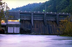
Wilbur Dam is a concrete gravity overflow dam 77 feet (23 m) high and 375 feet (114 m) long, and has a generating capacity of 10,700 kilowatts. The dam's spillway has four radial gates with a combined discharge of 34,000 cubic feet per second (960 m/s). The dam is located at just over
188:
In 1907, the Doe River Light & Power
Company began purchasing land rights for construction of Wilbur Dam, although the company struggled with finances and sold the project to the Watauga Power Company in 1910. Watauga Power completed the dam in just two years, and found a ready market for the
235:
The Upper
Holston Projects: Watauga, South Holston, Boone, and Fort Patrick Henry; a Comprehensive Report on the Planning, Design, Construction, Initial Operations, and Costs of Four Hydro Projects in the Holston Basin at the Eastern Tip of
396:
387:
877:
196:). In 1947, TVA outfitted the dam with a new gate-controlled spillway and raised it 5 feet (1.5 m) to accommodate the tailwaters of Watauga Dam, which was then nearing completion.
380:
892:
882:
373:
250:"Pre-TVA Hydroelectric Development in Tennessee" National Register of Historic Places Continuation Sheet Section number E, page 12. U.S. Department of Interior.
902:
872:
783:
597:
862:
177:. Wilbur Dam was one of the first major hydroelectric projects in Tennessee, and remains one of the oldest dams in the TVA system.
897:
763:
680:
59:
887:
457:
793:
808:
753:
710:
803:
798:
778:
773:
507:
788:
813:
758:
867:
831:
748:
400:
166:
725:
700:
213:
532:
477:
662:
158:
39:
695:
169:. The dam impounds Wilbur Lake, which extends for about 3 miles (4.8 km) up the Watauga to the base of
841:
685:
359:
343:
182:
527:
836:
627:
502:
768:
740:
730:
720:
705:
690:
675:
365:
432:
715:
582:
427:
315:
290:
The
Nickajack Project: A Report on the Planning, Design, Construction, Initial Operations, and Costs
823:
238:, Technical Report No. 14 (Washington, D.C.: U.S. Government Printing Office, 1958), pp. 1141-1143.
612:
670:
587:
482:
135:
602:
452:
437:
607:
592:
150:
247:
173:. Wilbur Dam was completed in 1912 making it the second oldest dam in the TVA system behind
512:
497:
412:
279:, Technical Report No. 24 (Washington, D.C.: Tennessee Valley Authority, 1952), pp. 220-221.
192:
Wilbur Dam was originally equipped with a flashboard-controlled spillway (similar to nearby
577:
572:
567:
537:
472:
292:, Technical Report No. 16 (Knoxville, Tenn.: Tennessee Valley Authority, 1972), pp. 10-11.
174:
622:
547:
442:
193:
856:
637:
542:
422:
154:
107:
47:
552:
522:
517:
467:
329:
642:
632:
617:
562:
492:
487:
462:
337:
181:
34 miles (55 km) above the mouth of the
Watauga, a few miles upstream from
170:
652:
557:
305:
74:
61:
447:
323:
162:
43:
28:
353:
260:
217:
277:
Design of TVA Projects Volume 3: Mechanical Design of Hydro Plants
369:
165:. It is one of two dams on the river owned and operated by the
408:
248:
https://npgallery.nps.gov/NRHP/GetAsset/NRHP/64500614_text
878:
Buildings and structures in Carter County, Tennessee
822:
739:
661:
407:
134:
129:
121:
113:
103:
98:
90:
53:
35:
21:
381:
8:
362:— Tennessee Wildlife Resources Agency
388:
374:
366:
18:
229:
227:
271:
269:
893:Energy infrastructure completed in 1912
883:Hydroelectric power plants in Tennessee
205:
7:
14:
903:1912 establishments in Tennessee
336:
322:
308:
27:
873:Tennessee Valley Authority dams
16:Dam in Tennessee, United States
263:. Retrieved: 2 February 2009.
1:
288:Tennessee Valley Authority,
275:Tennessee Valley Authority,
259:Tennessee Valley Authority,
233:Tennessee Valley Authority,
919:
401:Tennessee Valley Authority
167:Tennessee Valley Authority
863:Dams on the Watauga River
356:— official TVA site
26:
898:Elizabethton, Tennessee
663:Coal-fired power plants
344:Renewable energy portal
214:"TVA: Wilbur Reservoir"
183:Elizabethton, Tennessee
161:, in the U.S. state of
136:Installed capacity
888:Dams completed in 1912
125:375 feet (114 m)
75:36.34106°N 82.12624°W
824:Nuclear power plants
316:United States portal
415:generating stations
117:77 feet (23 m)
80:36.34106; -82.12624
71: /
741:Gas turbine plants
503:Fort Patrick Henry
868:Dams in Tennessee
850:
849:
528:Little Bear Creek
151:hydroelectric dam
144:
143:
99:Dam and spillways
91:Opening date
910:
628:Upper Bear Creek
598:Raccoon Mountain
583:Pickwick Landing
399:operated by the
390:
383:
376:
367:
360:Wilbur Reservoir
354:Wilbur Reservoir
346:
341:
340:
332:
327:
326:
318:
313:
312:
311:
293:
286:
280:
273:
264:
261:Wilbur Reservoir
257:
251:
245:
239:
231:
222:
221:
216:. Archived from
210:
140:10,700 kilowatts
86:
85:
83:
82:
81:
76:
72:
69:
68:
67:
64:
31:
19:
918:
917:
913:
912:
911:
909:
908:
907:
853:
852:
851:
846:
818:
735:
657:
414:
403:
394:
350:
349:
342:
335:
328:
321:
314:
309:
307:
302:
297:
296:
287:
283:
274:
267:
258:
254:
246:
242:
232:
225:
212:
211:
207:
202:
175:Ocoee Dam No. 1
79:
77:
73:
70:
65:
62:
60:
58:
57:
17:
12:
11:
5:
916:
914:
906:
905:
900:
895:
890:
885:
880:
875:
870:
865:
855:
854:
848:
847:
845:
844:
839:
834:
828:
826:
820:
819:
817:
816:
811:
806:
801:
796:
791:
786:
781:
776:
771:
766:
761:
756:
751:
745:
743:
737:
736:
734:
733:
728:
723:
718:
713:
708:
703:
698:
693:
688:
683:
678:
673:
667:
665:
659:
658:
656:
655:
650:
645:
640:
635:
630:
625:
620:
615:
610:
605:
600:
595:
590:
585:
580:
575:
570:
565:
560:
555:
550:
545:
540:
535:
530:
525:
520:
515:
510:
505:
500:
495:
490:
485:
480:
475:
470:
465:
460:
455:
450:
445:
440:
435:
430:
425:
419:
417:
405:
404:
395:
393:
392:
385:
378:
370:
364:
363:
357:
348:
347:
333:
319:
304:
303:
301:
300:External links
298:
295:
294:
281:
265:
252:
240:
223:
220:on 2002-04-25.
204:
203:
201:
198:
194:Nolichucky Dam
142:
141:
138:
132:
131:
127:
126:
123:
119:
118:
115:
111:
110:
105:
101:
100:
96:
95:
92:
88:
87:
55:
51:
50:
37:
33:
32:
24:
23:
15:
13:
10:
9:
6:
4:
3:
2:
915:
904:
901:
899:
896:
894:
891:
889:
886:
884:
881:
879:
876:
874:
871:
869:
866:
864:
861:
860:
858:
843:
840:
838:
835:
833:
830:
829:
827:
825:
821:
815:
812:
810:
807:
805:
802:
800:
797:
795:
792:
790:
787:
785:
782:
780:
777:
775:
772:
770:
767:
765:
762:
760:
757:
755:
752:
750:
747:
746:
744:
742:
738:
732:
729:
727:
724:
722:
719:
717:
714:
712:
709:
707:
704:
702:
699:
697:
694:
692:
689:
687:
684:
682:
679:
677:
674:
672:
669:
668:
666:
664:
660:
654:
651:
649:
646:
644:
641:
639:
636:
634:
631:
629:
626:
624:
621:
619:
616:
614:
611:
609:
608:South Holston
606:
604:
601:
599:
596:
594:
591:
589:
586:
584:
581:
579:
576:
574:
571:
569:
566:
564:
561:
559:
556:
554:
551:
549:
546:
544:
541:
539:
536:
534:
531:
529:
526:
524:
521:
519:
516:
514:
511:
509:
506:
504:
501:
499:
496:
494:
491:
489:
486:
484:
481:
479:
476:
474:
471:
469:
466:
464:
461:
459:
456:
454:
451:
449:
446:
444:
441:
439:
436:
434:
431:
429:
426:
424:
421:
420:
418:
416:
413:hydroelectric
410:
406:
402:
398:
391:
386:
384:
379:
377:
372:
371:
368:
361:
358:
355:
352:
351:
345:
339:
334:
331:
325:
320:
317:
306:
299:
291:
285:
282:
278:
272:
270:
266:
262:
256:
253:
249:
244:
241:
237:
230:
228:
224:
219:
215:
209:
206:
199:
197:
195:
190:
186:
184:
178:
176:
172:
168:
164:
160:
159:Carter County
156:
155:Watauga River
152:
148:
139:
137:
133:
130:Power Station
128:
124:
120:
116:
112:
109:
108:Watauga River
106:
102:
97:
93:
89:
84:
56:
52:
49:
48:United States
45:
41:
40:Carter County
38:
34:
30:
25:
20:
832:Browns Ferry
794:Lagoon Creek
784:Johnsonville
726:Widows Creek
701:Johnsonville
647:
513:Guntersville
498:Fort Loudoun
433:Beaver Creek
330:Water portal
289:
284:
276:
255:
243:
234:
218:the original
208:
191:
187:
179:
146:
145:
779:John Sevier
754:Brownsville
696:John Sevier
538:Melton Hill
508:Great Falls
478:Clear Creek
473:Chickamauga
458:Cedar Creek
171:Watauga Dam
78: /
54:Coordinates
857:Categories
686:Cumberland
548:Nolichucky
533:Lost Creek
443:Blue Ridge
428:Bear Creek
397:Facilities
200:References
147:Wilbur Dam
66:82°07′34″W
63:36°20′28″N
22:Wilbur Dam
842:Watts Bar
814:Southaven
759:Caledonia
721:Watts Bar
638:Watts Bar
623:Tims Ford
543:Nickajack
423:Apalachia
236:Tennessee
163:Tennessee
44:Tennessee
837:Sequoyah
809:Paradise
804:Marshall
799:Magnolia
769:Gallatin
711:Paradise
706:Kingston
691:Gallatin
676:Bull Run
613:Sycamore
553:Normandy
523:Kentucky
518:Hiwassee
468:Cherokee
104:Impounds
36:Location
774:Gleason
764:Colbert
716:Shawnee
681:Colbert
643:Wheeler
633:Watauga
618:Tellico
588:Pin Oak
578:Ocoee 3
573:Ocoee 2
568:Ocoee 1
563:Nottely
493:Fontana
488:Douglas
483:Dogwood
463:Chatuge
153:on the
789:Kemper
731:Wilson
653:Wilson
648:Wilbur
603:Redbud
558:Norris
122:Length
114:Height
749:Allen
671:Allen
453:Cedar
448:Boone
438:Beech
149:is a
593:Pine
411:and
409:Dams
94:1912
157:in
859::
268:^
226:^
185:.
46:,
42:,
389:e
382:t
375:v
Text is available under the Creative Commons Attribution-ShareAlike License. Additional terms may apply.