66:
49:
99:
396:
408:
106:
73:
369:. All the land in the polder is owned by De Koninklijke Maatschap de Wilhelminapolder. The company owns 1,700 hectares (4,200 acres) of land of which 1,300 hectares (3,200 acres) is used for agricultural. It is one of the largest landowners of the Netherlands.
644:
786:
776:
752:
65:
336:
327:
Wilhelminadorp was founded in 1812, when the
Wilhelminapolder was diked. Originally the polder was named Lodewijkspolder, after then King of Holland
286:
358:
The village was first mentioned in 1849 as "Wilhelminadorp, veelal het
Nieuwedorp genoemd". Wilhelminadorp is located on the canal from Goes to
134:
637:
771:
298:
98:
48:
654:
630:
407:
340:
278:
693:
395:
546:
166:
505:
688:
257:
380:, however the town hall was located in Wilhelminadorp. In 1970, it was merged into the municipality of
267:
708:
622:
359:
575:
373:
332:
328:
440:
725:
781:
765:
520:
376:, but the company paid for the church. It was originally part of the municipality of
17:
713:
698:
377:
313:
171:
741:
372:
Wilhelminadorp was home to 501 people in 1840. In 1841, a church was built by
604:
149:
136:
703:
414:
347:
248:
364:
317:
181:
274:
253:
331:
who had given the permit to start work. With the restoration of the
465:
672:
658:
381:
321:
191:
626:
335:, the name was changed in 1815. The polder was now named after
85:
Location in the province of
Zeeland in the Netherlands
734:
681:
665:
297:
285:
264:
247:
239:
231:
226:
218:
210:
205:
197:
187:
177:
165:
32:
350:(one Michelin star) is located in the village.
753:List of cities, towns and villages in Zeeland
638:
8:
645:
631:
623:
29:
599:
597:
570:
568:
427:
391:
320:. It is located in the municipality of
284:
246:
225:
217:
204:
196:
164:
129:
57:
45:
787:1812 establishments in the Netherlands
521:"Wilhelminadorp - (geografische naam)"
515:
513:
493:, Topografische Dienst and ANWB, 2005.
435:
433:
431:
105:
72:
296:
263:
238:
230:
209:
186:
176:
7:
777:Populated places established in 1812
506:De Geschiedenis van Goes en omgeving
441:"Kerncijfers wijken en buurten 2021"
214:10.66 km (4.12 sq mi)
491:ANWB Topografische Atlas Nederland
413:Former ferry house and restaurant
25:
406:
394:
104:
97:
71:
64:
47:
472:(in Dutch). Het Waterschapshuis
470:Actueel Hoogtebestand Nederland
27:Village in Zeeland, Netherlands
1:
445:Central Bureau of Statistics
341:William I of the Netherlands
118:Wilhelminadorp (Netherlands)
53:Drawbridge in Wilhelminadorp
772:Populated places in Zeeland
803:
750:
466:"Postcodetool for 4475AA"
130:
58:
46:
39:
694:'s-Heer Hendrikskinderen
653:Populated places in the
222:2.2 m (7.2 ft)
121:Show map of Netherlands
243:75/km (190/sq mi)
401:Dutch Reformed church
337:Wilhelmina of Prussia
266: • Summer (
312:is a village in the
240: • Density
150:51.52778°N 3.89611°E
18:Wilhelminadorp, Goes
689:'s-Heer Arendskerke
146: /
88:Show map of Zeeland
232: • Total
211: • Total
759:
758:
307:
306:
155:51.52778; 3.89611
16:(Redirected from
794:
717:
647:
640:
633:
624:
617:
616:
614:
612:
605:"Wilhelminadorp"
601:
592:
591:
589:
587:
576:"Wilhelminadorp"
572:
563:
562:
560:
558:
543:
537:
536:
534:
532:
517:
508:
504:
500:
494:
488:
482:
481:
479:
477:
462:
456:
455:
453:
451:
437:
410:
398:
368:
271:
161:
160:
158:
157:
156:
151:
147:
144:
143:
142:
139:
122:
108:
107:
101:
89:
75:
74:
68:
51:
30:
21:
802:
801:
797:
796:
795:
793:
792:
791:
762:
761:
760:
755:
746:
730:
711:
677:
661:
651:
621:
620:
610:
608:
603:
602:
595:
585:
583:
574:
573:
566:
556:
554:
545:
544:
540:
530:
528:
519:
518:
511:
502:
501:
497:
489:
485:
475:
473:
464:
463:
459:
449:
447:
439:
438:
429:
424:
417:
411:
402:
399:
390:
374:Rijkswaterstaat
362:
356:
333:House of Orange
329:Louis Bonaparte
293:
292:4474 & 4475
265:
154:
152:
148:
145:
140:
137:
135:
133:
132:
126:
125:
124:
123:
120:
119:
116:
115:
114:
113:
109:
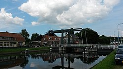
92:
91:
90:
87:
86:
83:
82:
81:
80:
76:
54:
42:
35:
28:
23:
22:
15:
12:
11:
5:
800:
798:
790:
789:
784:
779:
774:
764:
763:
757:
756:
751:
748:
747:
745:
744:
738:
736:
732:
731:
729:
728:
726:Wolphaartsdijk
723:
721:Wilhelminadorp
718:
706:
701:
696:
691:
685:
683:
679:
678:
676:
675:
669:
667:
663:
662:
652:
650:
649:
642:
635:
627:
619:
618:
593:
564:
551:Guide Michelin
538:
525:Etymologiebank
509:
495:
483:
457:
426:
425:
423:
420:
419:
418:
412:
405:
403:
400:
393:
389:
386:
355:
352:
310:Wilhelminadorp
305:
304:
301:
295:
294:
291:
289:
283:
282:
272:
262:
261:
251:
245:
244:
241:
237:
236:
233:
229:
228:
224:
223:
220:
216:
215:
212:
208:
207:
203:
202:
199:
195:
194:
189:
185:
184:
179:
175:
174:
169:
163:
162:
128:
127:
117:
112:Wilhelminadorp
111:
110:
103:
102:
96:
95:
94:
93:
84:
79:Wilhelminadorp
78:
77:
70:
69:
63:
62:
61:
60:
59:
56:
55:
52:
44:
43:
40:
37:
36:
34:Wilhelminadorp
33:
26:
24:
14:
13:
10:
9:
6:
4:
3:
2:
799:
788:
785:
783:
780:
778:
775:
773:
770:
769:
767:
754:
749:
743:
740:
739:
737:
733:
727:
724:
722:
719:
715:
710:
707:
705:
702:
700:
697:
695:
692:
690:
687:
686:
684:
680:
674:
671:
670:
668:
664:
660:
656:
648:
643:
641:
636:
634:
629:
628:
625:
606:
600:
598:
594:
581:
580:Zalig Zeeland
577:
571:
569:
565:
552:
548:
542:
539:
526:
522:
516:
514:
510:
507:
499:
496:
492:
487:
484:
471:
467:
461:
458:
446:
442:
436:
434:
432:
428:
421:
416:
409:
404:
397:
392:
387:
385:
383:
379:
375:
370:
366:
361:
353:
351:
349:
344:
342:
338:
334:
330:
325:
323:
319:
315:
311:
302:
300:
290:
288:
280:
276:
273:
269:
259:
255:
252:
250:
242:
234:
221:
213:
200:
193:
190:
183:
180:
173:
170:
168:
159:
131:Coordinates:
100:
67:
50:
38:
31:
19:
720:
709:Oud-Sabbinge
655:municipality
609:. Retrieved
584:. Retrieved
579:
555:. Retrieved
550:
541:
529:. Retrieved
524:
498:
490:
486:
474:. Retrieved
469:
460:
448:. Retrieved
444:
371:
357:
345:
326:
316:province of
309:
308:
299:Dialing code
188:Municipality
712: [
699:Kattendijke
547:"Katseveer"
378:Kattendijke
363: [
346:Restaurant
287:Postal code
198:Established
172:Netherlands
153: /
766:Categories
742:Wissekerke
607:(in Dutch)
582:(in Dutch)
553:(in Dutch)
527:(in Dutch)
503:(in Dutch)
422:References
339:, wife of
227:Population
138:51°31′40″N
704:Kloetinge
415:Katseveer
360:Goese Sas
348:Katseveer
249:Time zone
219:Elevation
141:3°53′46″E
682:Villages
611:19 April
586:19 April
557:19 April
531:19 April
476:19 April
450:19 April
178:Province
735:Hamlets
388:Gallery
354:History
318:Zeeland
182:Zeeland
167:Country
41:Village
716:]
666:Towns
367:]
314:Dutch
275:UTC+2
254:UTC+1
782:Goes
673:Goes
659:Goes
613:2022
588:2022
559:2022
533:2022
478:2022
452:2022
382:Goes
322:Goes
303:0113
279:CEST
206:Area
201:1812
192:Goes
657:of
268:DST
258:CET
235:800
768::
714:nl
596:^
578:.
567:^
549:.
523:.
512:^
468:.
443:.
430:^
384:.
365:nl
343:.
324:.
646:e
639:t
632:v
615:.
590:.
561:.
535:.
480:.
454:.
281:)
277:(
270:)
260:)
256:(
20:)
Text is available under the Creative Commons Attribution-ShareAlike License. Additional terms may apply.