52:
36:
59:
280:
of the
Pacific Railroad surveyed the area in 1853. His party crossed the Tehachapis by "one of the worst roads he ever saw." Hearing of a better road further west, he scouted it and found it would be far more practicable for wagons if the bulk of the traffic henceforth went that way. The name Tejon
159:. The mouth of the Canyon is 0.25 miles southwest of its confluence with Myrick Canyon Wash which is 300 feet southwest of the intersection of Munz Ranch Road with the Neenach - Fairmont Road in
302:
51:
148:
274:
Harrison Irving Scott, The Ridge Route: the Long Road to
Preservation; California HISTORIAN, www.californiahistorian.com website, accessed November 14, 2011
241:
106:
264:
Frank F. Latta, "EL CAMINO VIEJO á LOS ANGELES" - The Oldest Road of the San
Joaquin Valley]; Bear State Books, Exeter, 2006. p.21
20:
143:
is a canyon cut by Willow
Springs Canyon Wash. Its source is at the head of the canyon in the gap in the Portal Ridge of the
160:
71:
214:
240:
The wagons on the
Stockton - Los Angeles Road passed along the El Camino Viejo route through Tejon Pass then turned down
191:
99:
234:
277:
171:
248:
into the San
Joaquin Valley and the Old Tejon Pass route fell out of general use but it was favored by outlaws.
297:
222:
209:
route from Los
Angeles which followed that route to Mud Springs, then turned directly north across the
206:
218:
195:
156:
273:
144:
233:
into the San
Joaquin Valley and then north to the gold fields on the route that became the
230:
210:
183:
152:
276:, "The name Tejon formerly belonged to another pass 15 miles further east. Lieutenant
291:
164:
182:
Several early
California roads passed through Willow Springs Canyon. The first was
190:, which passed from Elizabeth Lake through the canyon before tuning northwest to
226:
187:
35:
245:
199:
75:
121:
108:
40:
Myrick Canyon in Portal Ridge two miles west of Willow
Springs Canyon.
19:
This article is about the canyon in Los Angeles. For other, see
16:
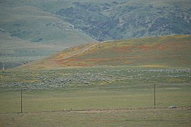
Canyon of the Sierra Pelona in Los Angeles County, California
170:
The closest populated place to Willow Springs Canyon is
225:, where it descended the west slope into the canyon of
151:. It is cut into the slope to the northeast into the
186:, established by the Spanish and later used by the
98:
93:
85:
28:
281:was transferred west to today's "Tejon Pass."
58:
8:
303:Geography of Los Angeles County, California
25:
217:, following it up the east slope of the
257:
229:, which the road followed down through
7:
198:before running west to what is now
14:
57:
50:
34:
21:Willow Springs (disambiguation)
161:Los Angeles County, California
1:
235:Stockton - Los Angeles Road
319:
278:Robert Stockton Williamson
172:Elizabeth Lake, California
18:
45:
33:
89:2.9 miles (4.7 km)
122:34.70944°N 118.35472°W
221:to cross them at the
147:, 0.5 miles north of
141:Willow Springs Canyon
65:Willow Springs Canyon
29:Willow Springs Canyon
127:34.70944; -118.35472
219:Tehachapi Mountains
157:California Aqueduct
118: /
72:Los Angeles County
138:
137:
310:
282:
271:
265:
262:
242:Grapevine Canyon
215:Cottonwood Creek
145:Transverse Range
133:
132:
130:
129:
128:
123:
119:
116:
115:
114:
111:
61:
60:
54:
38:
26:
318:
317:
313:
312:
311:
309:
308:
307:
298:El Camino Viejo
288:
287:
286:
285:
272:
268:
263:
259:
254:
231:Rancho El Tejon
211:Antelope Valley
184:El Camino Viejo
180:
155:, crossing the
153:Antelope Valley
126:
124:
120:
117:
112:
109:
107:
105:
104:
81:
80:
79:
78:
69:
68:
67:
66:
62:
41:
24:
17:
12:
11:
5:
316:
314:
306:
305:
300:
290:
289:
284:
283:
266:
256:
255:
253:
250:
223:old Tejon Pass
179:
176:
149:Elizabeth Lake
136:
135:
102:
96:
95:
91:
90:
87:
83:
82:
70:
64:
63:
56:
55:
49:
48:
47:
46:
43:
42:
39:
31:
30:
15:
13:
10:
9:
6:
4:
3:
2:
315:
304:
301:
299:
296:
295:
293:
279:
275:
270:
267:
261:
258:
251:
249:
247:
243:
238:
236:
232:
228:
224:
220:
216:
212:
208:
205:Next was the
203:
201:
197:
193:
189:
185:
177:
175:
173:
168:
166:
162:
158:
154:
150:
146:
142:
131:
103:
101:
97:
92:
88:
84:
77:
73:
53:
44:
37:
32:
27:
22:
269:
260:
239:
204:
181:
169:
140:
139:
227:Tejon Creek
196:Cow Springs
188:Californios
125: /
113:118°21′17″W
100:Coordinates
292:Categories
252:References
246:Fort Tejon
200:Tejon Pass
192:Mud Spring
110:34°42′34″N
76:California
94:Geography
178:History
134:
86:Length
244:past
207:49er
194:and
213:to
165:USA
294::
237:.
202:.
174:.
167:.
163:,
74:,
23:.
Text is available under the Creative Commons Attribution-ShareAlike License. Additional terms may apply.