42:
363:
351:
26:
49:
315:) from the southwest. Since 1932 the Windgfällweiher has been incorporated into the transfer of water from the Seebach to the Schluchsee (covered leat) and drained since then in the opposite direction i.e. to the south. The water is led via a ditch over the low watershed, initially as the
307:) with a dam in the north and the water surface raised by about 6 metres. At the same time the lake, which had only hitherto been fed from the east by the Kähnerbächle, was given another inflow in the form of a small
333:
On the wooded eastern shore of the Windgfällweiher, a lake barely touched by the streams of visitors to the area, lies a rather less picturesque bathing beach with a listed building.
272:
in the northwest to the
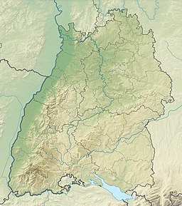
Schluchsee in the southeast and thus crosses the generally northeastward-running streams in the area. This remnant of a former valley is followed by the
88:
41:
467:
514:
519:
362:
482:
291:
in this trough, between the
Haslach in the north and the Ahabach in the south, now drowned by the impounded Schluchsee, the
402:
350:
250:
258:
303:
formed, the natural precursor to today's reservoir. This was enlarged in 1895 by the former Falkau Screw Works (
379:
327:
326:
Since 1950 the lake has been protected. In 2002 an angling and fish consumption ban was announced, because
254:
524:
132:
70:
234:
74:
453:
341:
296:
273:
439:
Map services of the Baden-Württemberg State Office for the
Environment, Survey and Conservation (
120:
242:
284:, which takes water from the Seebach valley via the Haslach valley to the Schluchsee Basin.
209:
288:
281:
269:
147:
508:
25:
230:
140:
103:
90:
262:
222:
330:
had been discovered in the sediment depositions on the bottom of the lake.
398:
438:
300:
337:
292:
246:
238:
226:
121:
133:
441:
Landesanstalt für Umwelt, Messungen und
Naturschutz Baden-Württemberg
276:
that was built between 1920 and 1926 and by the transfer channel (
425:. In: Landesanstalt für Umweltschutz Baden-Württemberg (Hrsg.):
308:
427:
Der
Feldberg im Schwarzwald. Subalpine Insel im Mittelgebirge
413:
In the geomorphological literature it is referred to as the
471:, Badische Zeitung, 25 May 2013, retrieved 23 November 2014
336:
The Windgfällweiher, together with the
Schluchsee and
468:
Behörden bewerten PCB-Altlast im Windgfällweiher neu
205:
201:
193:
185:
177:
169:
161:
157:
146:
131:
119:
80:
66:
18:
483:"Feldberg: Brezeln und stehend Paddeln am Weiher"
81:
268:The lake lies in a trough that runs from the
8:
423:Landschaftsgeschichte des Feldberggebietes
15:
261:on the territory of the municipality of
391:
346:
48:
403:Federal Agency for Nature Conservation
280:), built in 1932 and belonging to the
299:carved out a basin, in which a small
7:
249:glaciation between the villages of
14:
340:, contributed to the name of the
361:
349:
139:Windgefällbach (channel) to the
47:
40:
24:
245:and lies in a hollow formed by
192:
184:
176:
168:
160:
1:
485:(in German). Badische Zeitung
429:, Karlsruhe 1982, pp. 13–147)
368:The Windgfällweiher in winter
65:
197:966.2 metres (3,170 ft)
481:Tina Hättich (2013-06-08).
241:. It is located within the
541:
515:Lakes of Baden-Württemberg
181:19.81 ha (49.0 acres)
173:0.4 km (0.25 mi)
165:0.7 km (0.43 mi)
520:Lakes of the Black Forest
421:valley. (Ekkehard Liehl:
35:
23:
380:List of lakes in Germany
356:View of the bathing area
323:, into the Schluchsee.
287:North of the low-lying
456:bei hochschwarzwald.de
305:Schraubenfabrik Falkau
189:6 m (20 ft)
71:Southern Black Forest
104:47.85194°N 8.12583°E
342:Three Lakes Railway
274:Three Lakes Railway
100: /
278:Überleitungskanal
243:High Black Forest
235:Baden-Württemberg
215:
214:
194:Surface elevation
109:47.85194; 8.12583
75:Baden-Württemberg
532:
494:
493:
491:
490:
478:
472:
463:
457:
451:
445:
436:
430:
411:
405:
396:
365:
353:
233:in the south of
210:Titisee-Neustadt
135:
134:Primary outflows
123:
115:
114:
112:
111:
110:
105:
101:
98:
97:
96:
93:
83:
51:
50:
44:
30:View of the lake
28:
16:
540:
539:
535:
534:
533:
531:
530:
529:
505:
504:
503:
498:
497:
488:
486:
480:
479:
475:
464:
460:
454:Windgfällweiher
452:
448:
437:
433:
412:
408:
397:
393:
388:
376:
369:
366:
357:
354:
319:and later, the
219:Windgfällweiher
150: countries
122:Primary inflows
108:
106:
102:
99:
94:
91:
89:
87:
86:
62:
61:
60:
59:
58:
57:
56:
55:Windgfällweiher
52:
31:
19:Windgfällweiher
12:
11:
5:
538:
536:
528:
527:
522:
517:
507:
506:
502:
501:External links
499:
496:
495:
473:
458:
446:
431:
406:
390:
389:
387:
384:
383:
382:
375:
372:
371:
370:
367:
360:
358:
355:
348:
317:Windgefällbach
282:Schluchseewerk
270:Seebach valley
213:
212:
207:
203:
202:
199:
198:
195:
191:
190:
187:
183:
182:
179:
175:
174:
171:
167:
166:
163:
159:
158:
155:
154:
151:
144:
143:
137:
129:
128:
125:
117:
116:
84:
78:
77:
68:
64:
63:
54:
53:
46:
45:
39:
38:
37:
36:
33:
32:
29:
21:
20:
13:
10:
9:
6:
4:
3:
2:
537:
526:
523:
521:
518:
516:
513:
512:
510:
500:
484:
477:
474:
470:
469:
462:
459:
455:
450:
447:
444:
442:
435:
432:
428:
424:
420:
416:
410:
407:
404:
400:
395:
392:
385:
381:
378:
377:
373:
364:
359:
352:
347:
345:
343:
339:
334:
331:
329:
324:
322:
318:
314:
310:
306:
302:
298:
294:
290:
285:
283:
279:
275:
271:
266:
264:
260:
256:
252:
251:Altglashütten
248:
244:
240:
236:
232:
228:
224:
220:
211:
208:
204:
200:
196:
188:
180:
172:
164:
156:
152:
149:
145:
142:
138:
136:
130:
126:
124:
118:
113:
85:
79:
76:
72:
69:
43:
34:
27:
22:
17:
525:Wutach basin
487:. Retrieved
476:
466:
465:Ralf Morys:
461:
449:
440:
434:
426:
422:
418:
414:
409:
399:Map services
394:
335:
332:
325:
320:
316:
312:
304:
297:last ice age
286:
277:
267:
225:between the
218:
216:
178:Surface area
127:Kähnerbächle
415:Ur-Schwarza
206:Settlements
162:Max. length
107: /
82:Coordinates
509:Categories
489:2016-12-23
386:References
321:Schwarzach
231:Schluchsee
186:Max. depth
170:Max. width
141:Schluchsee
95:08°07′33″E
92:47°51′07″N
419:Ur-Mettma
313:Hangkanal
289:watershed
263:Lenzkirch
223:reservoir
374:See also
301:bog lake
229:and the
67:Location
401:of the
338:Titisee
295:of the
293:glacier
247:ice age
239:Germany
227:Titisee
153:Germany
255:Falkau
221:is a
148:Basin
309:leat
257:and
217:The
417:or
328:PCB
259:Aha
511::
344:.
265:.
253:,
237:,
73:,
492:.
443:)
311:(
Text is available under the Creative Commons Attribution-ShareAlike License. Additional terms may apply.