22:
257:
134:
173:
298:
205:
89:, blindfold driving and tractor driving. It also features a converted farm building which is now used as a luxury event venue, offering birthdays,
322:
327:
218:
332:
291:
62:
on four occasions. The village is also home to some notable buildings. The site of The Belfry was once the location of
Moxhull Park, a
180:
317:
284:
113:. The mast was felled by unknown vandals in November 2003 and subsequent pressure against plans to replace it led operator
66:
that belonged to the Ryland family (previously the Halket family) until it burnt down in the early twentieth century. The
25:
44:
114:
85:
Wishaw is also the home of Wishaw
Country Sports, a diverse venue that offers a variety of activities such as
106:
102:
155:
48:
199:
268:
98:
93:
and other functions upon request. Wishaw is located about one mile north of the village of
110:
311:
256:
264:
71:
63:
40:
36:
67:
21:
75:
52:
233:
220:
94:
59:
90:
86:
79:
82:
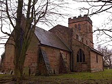
and regular Sunday services, despite a very small local population.
70:
was rebuilt one mile away to its present location on Holly Lane as
20:
74:. Wishaw is also the location of a church dedicated to the local
55:
272:
109:
at the centre of the village was the cause of a local
43:, England. The population of the civil parish at the
16:Village and civil parish in Warwickshire, England
47:was 125. It is located within the district of
292:
8:
156:"BBC Inside Out - Phone Masts: health risk?"
299:
285:
97:and about three miles east of the town of
26:St. Chad's Church, located on The Gravel
126:
204:: CS1 maint: archived copy as title (
197:
7:
253:
251:
105:. In 2003, residents claimed that a
271:. You can help Knowledge (XXG) by
14:
255:
323:Civil parishes in Warwickshire
135:"Civil Parish population 2011"
1:
328:Borough of North Warwickshire
78:. The church is popular with
58:resort, which has hosted the
333:Warwickshire geography stubs
349:
250:
318:Villages in Warwickshire
267:location article is a
29:
117:to abandon the site.
39:in the north-west of
24:
230: /
186:on 22 December 2005
51:and is the home of
49:North Warwickshire
30:
280:
279:
107:mobile phone mast
35:is a village and
340:
301:
294:
287:
259:
252:
245:
244:
242:
241:
240:
235:
234:52.549°N 1.741°W
231:
228:
227:
226:
223:
210:
209:
203:
195:
193:
191:
185:
179:. Archived from
178:
170:
164:
163:
152:
146:
145:
143:
141:
131:
99:Sutton Coldfield
348:
347:
343:
342:
341:
339:
338:
337:
308:
307:
306:
305:
248:
238:
236:
232:
229:
224:
221:
219:
217:
216:
214:
213:
196:
189:
187:
183:
176:
174:"Archived copy"
172:
171:
167:
154:
153:
149:
139:
137:
133:
132:
128:
123:
17:
12:
11:
5:
346:
344:
336:
335:
330:
325:
320:
310:
309:
304:
303:
296:
289:
281:
278:
277:
260:
239:52.549; -1.741
212:
211:
165:
147:
125:
124:
122:
119:
111:cancer cluster
15:
13:
10:
9:
6:
4:
3:
2:
345:
334:
331:
329:
326:
324:
321:
319:
316:
315:
313:
302:
297:
295:
290:
288:
283:
282:
276:
274:
270:
266:
261:
258:
254:
249:
246:
243:
207:
201:
182:
175:
169:
166:
161:
160:www.bbc.co.uk
157:
151:
148:
136:
130:
127:
120:
118:
116:
112:
108:
104:
103:West Midlands
100:
96:
92:
88:
83:
81:
77:
73:
69:
65:
61:
57:
54:
50:
46:
42:
38:
34:
27:
23:
19:
273:expanding it
265:Warwickshire
262:
247:
215:
188:. Retrieved
181:the original
168:
159:
150:
138:. Retrieved
129:
84:
72:Moxhull Hall
64:stately home
41:Warwickshire
37:civil parish
32:
31:
18:
237: /
190:19 December
68:manor house
45:2011 census
312:Categories
222:52°32′56″N
121:References
76:Saint Chad
53:The Belfry
225:1°44′28″W
140:3 January
101:, in the
95:Curdworth
80:marriages
60:Ryder Cup
200:cite web
115:T-Mobile
91:weddings
87:shooting
33:Wishaw
263:This
184:(PDF)
177:(PDF)
269:stub
206:link
192:2005
142:2016
56:golf
314::
202:}}
198:{{
158:.
300:e
293:t
286:v
275:.
208:)
194:.
162:.
144:.
28:.
Text is available under the Creative Commons Attribution-ShareAlike License. Additional terms may apply.