53:
73:
144:
395:
Nruk comes from
Tseminyü, crosses through Moilan and joins the Doyang. Other waterbodies in the district include small lakes across the ranges. The Totsü Wozhü which is situated in the southern part of the Phiro–Shaki area is the largest amongst these but occupies merely around an acre of land. Other similar natural lakes are situated in the Sanis and Mekokla areas. The lake created by the
369:. Of the total area, 35.74% comes under subtropical hill zone, 23.64% under subtropical plain zone and 40.59% in the mild tropical hill zone. The average altitude of the Wokha (Upper Range) is 1000-1500m above sea level; Bhandari (Lower Range) is 400-1000m above sea level. While Baghty town is at an altitude of 304.30m above sealevel, Wokha town is the highest town at 1313.69m.
1557:
1574:
1549:
124:
1528:
255:
318:, Wokha was designated the district headquarters initially. Two years later, it was shifted to Kohima in 1878, and Wokha was reduced to a sub-division in the colonial administration. The sub-divisional administration shifted its headquarters to Mokokchung further relegating Wokha in the colonial administration.
394:
in the Assam valley. The other three important rivers flowing down its mountains are, Chubi, Nzhu and Nruk. Chubi flows southwards from
Mokokchung District and joins Doyang in the Pangti area. Nzhu rises from Tseminyü District, flows through Miphong and joins the Doyang in the Lotsü area. The river
433:
The district has four assembly constituencies and 125 recognized villages. It is further divided into 13 administrative units and 7 rural development blocks. It has three ranges namely, Upper Range covering the Wokha, Wozhüro, Chükitong and Englan Circle, Middle Range covering the Lotsü, Sanis and
414:
Due to its subtropical topography, the district receives warm rainy summer and cold dry winter. In winter, the average night temperature falls between 4 °C to 2 °C. December and
January are the coldest months. The average temperature in the summer months in approximately 27 °C. The
372:
Mount Tiyi is the highest peak in the district at an altitude of 1970 metres above sea-level. It has a rich biodiversity. Mount Tiyi is of great cultural significance to the Lotha tribe with many legends and myth embedded into the cultural history. Mount Totsü is the second highest peak with an
415:
district receives an average annual rainfall of 2000mm to 2500mm and rains for around six months in a year with greater intensity in the months of July and August. Although the district receives moderate rainfall, villages at higher elevation face acute scarcity of water due to the high
313:
In 1844, the first official colonial exploration in the Lotha Naga area was carried out by
Captain Brodie. The first recorded meeting between a European and the Lothas was with Lieutenant Biggs in the year 1841. During the British colonial expansion into the
406:(Falcon Amurensis) use the area around Doyang reservoir as a feeding and resting place and around a million gather during the season. The best time to view roosting of the birds is from second week of October to the first week of November.
329:
The currently defined Wokha
District was created in 1973 when the sub-division was separated from Mokokchung District along with six administrative circles. The first census of the new district in 1981 counted the population to be 57,583.
176:
390:) is the biggest river in the state, and the district, and flows through the three hill ranges, namely, Bhandari Range, Sanis Range and Wokha Range. It goes further to join the
1647:
1442:
1418:
957:
1486:
1376:
52:
296:. Gastronomically, it known for its variety of fermented bamboo shoots (bastenga). It holds an important place as the roosting site of the migratory
1991:
399:
is the biggest manmade waterbody in the district. There are no permanent waterfalls in the district though several are formed during the monsoons.
1634:
934:
171:
86:
1749:
1625:
1479:
1432:
801:
1408:
1986:
373:
altitude of 1250 metres above the sea-level. Both these places are earmarked by the district administration for ecotourism.
1821:
1759:
1754:
1744:
1472:
396:
39:
422:
During summer, the average humidity is 85%, which can go uptown 95% to 100%, which makes the monsoon season very damp.
326:
In 1957, when the Naga Hills
Tuensang Area (NHTA) was formed, Wokha became a sub-division under the Mokokchung District.
1715:
1696:
1678:
1669:
1661:
72:
1380:
447:
1705:
1687:
259:
1297:
1270:
1216:
1158:
1131:
1104:
896:
844:
817:
425:
The climate in the
Bhandari Range is slightly warmer with little lesser compared to the middle and upper ranges.
580:
According to the 2011 official census, Christianity is the predominant religion in Wokha
District with 158.236
514:
1981:
486:
of 87.7%. Scheduled Tribes make up 94.16% of the population. 21.04% of the population live in urban areas.
1736:
1618:
1700:
463:
281:
1563:
1585:
1069:
Ezung, T. Zarenthung (19 October 2012). "Rural
Tourism in Nagaland, India: Exploring the Potential".
1034:
Ezüng, T. Zarenthung (19 October 2012). "Rural
Tourism in Nagaland, India: Exploring the Potential".
529:
459:
351:
226:
1849:
1691:
1517:
343:
1945:
1889:
1764:
1726:
1673:
1086:
1051:
951:
471:
347:
1879:
1874:
1844:
1787:
1779:
1611:
1537:
930:
797:
483:
746:
1834:
1829:
1709:
1590:
1078:
1043:
923:
Ray, Sanjay Kumar; Chatterjee2, Dibyendu; Saha, Saurav; Kamble, Kalpana H.; Deka, Bidyut C.
723:
355:
1859:
1839:
1769:
1508:
1437:
1413:
1325:
382:
136:
1243:
971:
1864:
1797:
719:
479:
416:
391:
247:
1975:
1869:
1186:
1090:
1055:
924:
239:
1464:
1854:
885:: Development Commissioner Ministry of Micro, Small & Medium Enterprises. 2012.
871:
365:
It covers an area of 1,628 sq. km. which equals around 9.82% of the total area of
1935:
1792:
747:"Wokha District Population Census 2011, Nagaland literacy sex ratio and density"
467:
403:
387:
297:
1930:
1920:
581:
434:
Aitepyong Circle and Lower Range covering the Bhandari Circle and Ralan area.
315:
293:
222:
1082:
1047:
101:
88:
475:
217:
1353:
767:
1112:. Kohima: Directorate of Census Operations, Nagaland. 2011. pp. 10–11
1960:
1915:
1638:
593:
366:
339:
285:
234:
148:
43:
1000:"Traditional knowledge of Lotha-Naga tribes in Wokha district, Nagaland"
16:
This article is about the district. For its eponymous headquarters, see
1940:
1905:
999:
882:
601:
589:
1305:. Kohima: Directorate of Census Operations, Nagaland. 2011. p. 11
1278:. Kohima: Directorate of Census Operations, Nagaland. 2011. p. 11
1224:. Kohima: Directorate of Census Operations, Nagaland. 2011. p. 11
1166:. Kohima: Directorate of Census Operations, Nagaland. 2011. p. 11
1139:. Kohima: Directorate of Census Operations, Nagaland. 2011. p. 11
1029:
1027:
1025:
852:. Kohima: Directorate of Census Operations, Nagaland. 2011. p. 18
1950:
1910:
1652:
904:. Kohima: Directorate of Census Operations, Nagaland. 2011. p. 8
825:. Kohima: Directorate of Census Operations, Nagaland. 2011. p. 8
794:
A Treatise on Customary and Fundamental Laws of the Nagas in Nagaland
585:
377:
1603:
926:
A Guide for Soil Nutrient Management with special reference to Wokha
1251:. Guwahati: Central Ground Water Board (North Eastern Region). 2013
979:. Guwahati: Central Ground Water Board (North Eastern Region). 2013
1925:
1682:
1541:
1512:
597:
544:
359:
338:
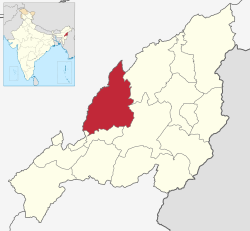
Wokha District is located in the midwest part of present state of
289:
158:
129:
17:
604:(<0.01%), 79 did not answer (0.05%) and 20 did Other (0.01%).
1955:
470:. This gives it a ranking of 595th in India (out of a total of
1607:
1468:
929:. Jharnapani: ICAR Research Complex for NEH Region. p. 3.
718:
At the time of the 2011 census, 90.48% of the population spoke
1245:
Ground Water Information Booklet: Wokha District, Nagaland
973:
Ground Water Information Booklet: Wokha District, Nagaland
1459:
269:
872:"District industrial profile report of Wokha district"
1326:"A Note on the Backward Regions Grant Fund Programme"
762:
760:
1898:
1820:
1806:
1778:
1735:
1660:
265:
246:
233:
216:
208:
200:
195:
187:
182:
169:
164:
154:
135:
117:
30:
1443:Registrar General and Census Commissioner of India
1433:"Table C-16 Population by Mother Tongue: Nagaland"
1419:Registrar General and Census Commissioner of India
741:
739:
1348:
1346:
1324:Ministry of Panchayati Raj (8 September 2009).
1187:"Doyang Reservoir: A potential IBA in Nagaland"
1619:
1480:
8:
998:Jamir, N. S.; Takatemjen; Limasemba (2010).
358:on its southwest and the Golaghat plains of
1403:
1401:
956:: CS1 maint: numeric names: authors list (
466:of 166,343, roughly equal to the nation of
300:. Geologically, it has known oil deposits.
1626:
1612:
1604:
1487:
1473:
1465:
419:leading to less recharge of ground water.
27:
1331:. National Institute of Rural Development
1071:International Journal of Rural Management
1036:International Journal of Rural Management
606:
1004:Indian Journal of Traditional Knowledge
772:District Administration, Wokha District
735:
264:
245:
232:
215:
194:
181:
163:
153:
116:
81:
69:
61:
49:
949:
448:Backward Regions Grant Fund Programme
207:
199:
186:
168:
134:
7:
1502:
442:It is one of the three districts in
1409:"Population by Religion - Nagaland"
446:currently receiving funds from the
191:1,628 km (629 sq mi)
1393:Saint Lucia 161,557 July 2011 est.
499:Religions in Wokha district (2011)
14:
1495:Places adjacent to Wokha district
1572:
1555:
1547:
1526:
1375:US Directorate of Intelligence.
253:
142:
122:
71:
51:
1992:1973 establishments in Nagaland
1377:"Country Comparison:Population"
1299:District Census Handbook, Wokha
1272:District Census Handbook, Wokha
1218:District Census Handbook, Wokha
1160:District Census Handbook, Wokha
1133:District Census Handbook, Wokha
1106:District Census Handbook, Wokha
898:District Census Handbook, Wokha
846:District Census Handbook, Wokha
819:District Census Handbook, Wokha
309:British Colonial Administration
1:
1573:
1527:
25:District of Nagaland in India
1556:
1548:
482:for every 1000 males, and a
1460:Official Government website
2008:
15:
1722:
1645:
1500:
796:. Chennai: Notion Press.
726:as their first language.
572:Distribution of religions
571:
566:
558:
553:
543:
538:
528:
523:
513:
508:
503:
498:
82:
70:
62:
50:
37:
1356:. Census2011.co.in. 2011
1083:10.1177/0973005212459833
1048:10.1177/0973005212459833
474:). Wokha District has a
292:. It is the home of the
212:100/km (260/sq mi)
172:Assembly constituencies
1354:"District Census 2011"
1185:Kasambe, Raju (2014).
342:. It is surrounded by
1987:Districts of Nagaland
1899:Main cities and towns
792:Ao, Moatoshi (2019).
462:Wokha District has a
280:(Pron:/ˈwəʊkə/) is a
1755:Legislative Assembly
768:"Places of Interest"
751:www.census2011.co.in
608:Religions by gender
322:District of Nagaland
270:http://wokha.nic.in/
209: • Density
77:Location in Nagaland
1518:Mokokchung district
609:
559:Other or not stated
344:Mokokchung District
98: /
1727:Emblem of Nagaland
1674:Emblem of Nagaland
1564:Zünheboto district
607:
350:to its southeast,
348:Zunheboto District
346:to its northeast,
201: • Total
188: • Total
1969:
1968:
1760:Political parties
1716:Chocolate mahseer
1601:
1600:
1596:
1595:
1586:Tseminyü district
1538:Golaghat district
936:978-81-931382-1-2
711:
710:
576:
575:
458:According to the
352:Tseminyü District
275:
274:
102:26.100°N 94.267°E
1999:
1729:
1692:Blyth's tragopan
1628:
1621:
1614:
1605:
1591:Niuland district
1576:
1575:
1559:
1558:
1551:
1550:
1530:
1529:
1503:
1489:
1482:
1475:
1466:
1447:
1446:
1429:
1423:
1422:
1405:
1396:
1395:
1390:
1388:
1379:. Archived from
1372:
1366:
1365:
1363:
1361:
1350:
1341:
1340:
1338:
1336:
1330:
1321:
1315:
1314:
1312:
1310:
1304:
1294:
1288:
1287:
1285:
1283:
1277:
1267:
1261:
1260:
1258:
1256:
1250:
1240:
1234:
1233:
1231:
1229:
1223:
1213:
1207:
1206:
1204:
1202:
1182:
1176:
1175:
1173:
1171:
1165:
1155:
1149:
1148:
1146:
1144:
1138:
1128:
1122:
1121:
1119:
1117:
1111:
1101:
1095:
1094:
1077:(1–2): 133–147.
1066:
1060:
1059:
1042:(1–2): 133–147.
1031:
1020:
1019:
1017:
1015:
995:
989:
988:
986:
984:
978:
968:
962:
961:
955:
947:
945:
943:
920:
914:
913:
911:
909:
903:
893:
887:
886:
876:
868:
862:
861:
859:
857:
851:
841:
835:
834:
832:
830:
824:
814:
808:
807:
789:
783:
782:
780:
778:
764:
755:
754:
743:
610:
584:(95.13%), 5.605
496:
495:
356:Niuland District
258:
257:
256:
177:4 constituencies
147:
146:
145:
128:
126:
125:
113:
112:
110:
109:
108:
103:
99:
96:
95:
94:
91:
75:
57:Doyang Reservoir
55:
28:
2007:
2006:
2002:
2001:
2000:
1998:
1997:
1996:
1972:
1971:
1970:
1965:
1894:
1816:
1802:
1774:
1750:Chief Ministers
1731:
1730:
1725:
1720:
1656:
1641:
1632:
1602:
1597:
1560:
1509:Jorhat district
1496:
1493:
1456:
1451:
1450:
1438:Census of India
1431:
1430:
1426:
1414:Census of India
1407:
1406:
1399:
1386:
1384:
1383:on 13 June 2007
1374:
1373:
1369:
1359:
1357:
1352:
1351:
1344:
1334:
1332:
1328:
1323:
1322:
1318:
1308:
1306:
1302:
1296:
1295:
1291:
1281:
1279:
1275:
1269:
1268:
1264:
1254:
1252:
1248:
1242:
1241:
1237:
1227:
1225:
1221:
1215:
1214:
1210:
1200:
1198:
1184:
1183:
1179:
1169:
1167:
1163:
1157:
1156:
1152:
1142:
1140:
1136:
1130:
1129:
1125:
1115:
1113:
1109:
1103:
1102:
1098:
1068:
1067:
1063:
1033:
1032:
1023:
1013:
1011:
997:
996:
992:
982:
980:
976:
970:
969:
965:
948:
941:
939:
937:
922:
921:
917:
907:
905:
901:
895:
894:
890:
874:
870:
869:
865:
855:
853:
849:
843:
842:
838:
828:
826:
822:
816:
815:
811:
804:
791:
790:
786:
776:
774:
766:
765:
758:
745:
744:
737:
732:
716:
588:(3.37%), 2.043
578:
577:
564:
551:
536:
521:
492:
456:
440:
431:
412:
380:(also known as
336:
324:
311:
306:
254:
252:
143:
141:
123:
121:
106:
104:
100:
97:
92:
89:
87:
85:
84:
78:
66:
63:Nickname:
58:
46:
33:
26:
21:
12:
11:
5:
2005:
2003:
1995:
1994:
1989:
1984:
1982:Wokha district
1974:
1973:
1967:
1966:
1964:
1963:
1958:
1953:
1951:Kohima Village
1948:
1943:
1938:
1933:
1928:
1923:
1918:
1913:
1908:
1902:
1900:
1896:
1895:
1893:
1892:
1887:
1882:
1877:
1872:
1867:
1862:
1857:
1852:
1847:
1842:
1837:
1832:
1826:
1824:
1818:
1817:
1815:
1814:
1810:
1808:
1804:
1803:
1801:
1800:
1795:
1790:
1784:
1782:
1776:
1775:
1773:
1772:
1767:
1762:
1757:
1752:
1747:
1741:
1739:
1733:
1732:
1724:
1723:
1721:
1719:
1718:
1712:
1703:
1694:
1685:
1676:
1666:
1664:
1658:
1657:
1646:
1643:
1642:
1633:
1631:
1630:
1623:
1616:
1608:
1599:
1598:
1594:
1593:
1588:
1583:
1580:
1579:
1577:
1570:
1567:
1566:
1561:
1553:Wokha district
1546:
1544:
1534:
1533:
1531:
1524:
1521:
1520:
1515:
1506:
1501:
1498:
1497:
1494:
1492:
1491:
1484:
1477:
1469:
1463:
1462:
1455:
1454:External links
1452:
1449:
1448:
1424:
1397:
1367:
1342:
1316:
1289:
1262:
1235:
1208:
1177:
1150:
1123:
1096:
1061:
1021:
990:
963:
935:
915:
888:
863:
836:
809:
802:
784:
756:
734:
733:
731:
728:
715:
712:
709:
708:
705:
702:
698:
697:
694:
691:
687:
686:
683:
680:
676:
675:
672:
669:
665:
664:
661:
658:
654:
653:
650:
647:
643:
642:
639:
636:
632:
631:
628:
625:
621:
620:
617:
614:
574:
573:
569:
568:
565:
562:
560:
556:
555:
552:
549:
547:
541:
540:
537:
534:
532:
526:
525:
522:
519:
517:
511:
510:
507:
505:
501:
500:
494:
493:
491:
488:
455:
452:
439:
436:
430:
429:Administration
427:
417:surface runoff
411:
408:
402:The migratory
392:Dhansiri River
354:to its south,
335:
332:
323:
320:
310:
307:
305:
302:
278:Wokha District
273:
272:
267:
263:
262:
250:
248:Major highways
244:
243:
237:
231:
230:
220:
214:
213:
210:
206:
205:
202:
198:
197:
193:
192:
189:
185:
184:
180:
179:
174:
167:
166:
162:
161:
156:
152:
151:
139:
133:
132:
119:
115:
114:
107:26.100; 94.267
80:
79:
76:
68:
67:
65:Land of Plenty
64:
60:
59:
56:
48:
47:
38:
35:
34:
32:Wokha District
31:
24:
13:
10:
9:
6:
4:
3:
2:
2004:
1993:
1990:
1988:
1985:
1983:
1980:
1979:
1977:
1962:
1959:
1957:
1954:
1952:
1949:
1947:
1944:
1942:
1939:
1937:
1934:
1932:
1929:
1927:
1924:
1922:
1919:
1917:
1914:
1912:
1909:
1907:
1904:
1903:
1901:
1897:
1891:
1888:
1886:
1883:
1881:
1878:
1876:
1873:
1871:
1868:
1866:
1863:
1861:
1858:
1856:
1853:
1851:
1848:
1846:
1843:
1841:
1838:
1836:
1833:
1831:
1828:
1827:
1825:
1823:
1819:
1812:
1811:
1809:
1805:
1799:
1798:Highest point
1796:
1794:
1791:
1789:
1786:
1785:
1783:
1781:
1777:
1771:
1768:
1766:
1763:
1761:
1758:
1756:
1753:
1751:
1748:
1746:
1743:
1742:
1740:
1738:
1734:
1728:
1717:
1713:
1711:
1707:
1704:
1702:
1698:
1695:
1693:
1689:
1686:
1684:
1680:
1677:
1675:
1671:
1668:
1667:
1665:
1663:
1662:State symbols
1659:
1655:
1654:
1649:
1644:
1640:
1636:
1629:
1624:
1622:
1617:
1615:
1610:
1609:
1606:
1592:
1589:
1587:
1584:
1582:
1581:
1578:
1571:
1569:
1568:
1565:
1562:
1554:
1545:
1543:
1539:
1536:
1535:
1532:
1525:
1523:
1522:
1519:
1516:
1514:
1510:
1507:
1505:
1504:
1499:
1490:
1485:
1483:
1478:
1476:
1471:
1470:
1467:
1461:
1458:
1457:
1453:
1444:
1440:
1439:
1434:
1428:
1425:
1420:
1416:
1415:
1410:
1404:
1402:
1398:
1394:
1382:
1378:
1371:
1368:
1355:
1349:
1347:
1343:
1327:
1320:
1317:
1301:
1300:
1293:
1290:
1274:
1273:
1266:
1263:
1247:
1246:
1239:
1236:
1220:
1219:
1212:
1209:
1196:
1192:
1188:
1181:
1178:
1162:
1161:
1154:
1151:
1135:
1134:
1127:
1124:
1108:
1107:
1100:
1097:
1092:
1088:
1084:
1080:
1076:
1072:
1065:
1062:
1057:
1053:
1049:
1045:
1041:
1037:
1030:
1028:
1026:
1022:
1009:
1005:
1001:
994:
991:
975:
974:
967:
964:
959:
953:
938:
932:
928:
927:
919:
916:
900:
899:
892:
889:
884:
880:
873:
867:
864:
848:
847:
840:
837:
821:
820:
813:
810:
805:
803:9781645464778
799:
795:
788:
785:
773:
769:
763:
761:
757:
752:
748:
742:
740:
736:
729:
727:
725:
721:
713:
706:
703:
700:
699:
695:
692:
689:
688:
684:
681:
678:
677:
673:
670:
667:
666:
662:
659:
656:
655:
651:
648:
645:
644:
640:
637:
634:
633:
629:
626:
624:Christianity
623:
622:
618:
615:
612:
611:
605:
603:
599:
595:
592:(1.23%), 318
591:
587:
583:
570:
561:
557:
548:
546:
542:
533:
531:
527:
518:
516:
512:
506:
502:
497:
489:
487:
485:
484:literacy rate
481:
477:
473:
469:
465:
461:
453:
451:
449:
445:
437:
435:
428:
426:
423:
420:
418:
409:
407:
405:
400:
398:
393:
389:
385:
384:
379:
374:
370:
368:
363:
362:to the west.
361:
357:
353:
349:
345:
341:
333:
331:
327:
321:
319:
317:
308:
303:
301:
299:
295:
291:
287:
283:
279:
271:
268:
261:
251:
249:
241:
238:
236:
235:ISO 3166 code
228:
224:
221:
219:
211:
203:
190:
178:
175:
173:
170: •
160:
157:
150:
140:
138:
131:
120:
111:
83:Coordinates:
74:
54:
45:
41:
36:
29:
23:
19:
1884:
1701:Rhododendron
1651:
1552:
1436:
1427:
1412:
1392:
1385:. Retrieved
1381:the original
1370:
1360:30 September
1358:. Retrieved
1335:27 September
1333:. Retrieved
1319:
1307:. Retrieved
1298:
1292:
1280:. Retrieved
1271:
1265:
1253:. Retrieved
1244:
1238:
1226:. Retrieved
1217:
1211:
1199:. Retrieved
1194:
1190:
1180:
1168:. Retrieved
1159:
1153:
1141:. Retrieved
1132:
1126:
1114:. Retrieved
1105:
1099:
1074:
1070:
1064:
1039:
1035:
1012:. Retrieved
1007:
1003:
993:
981:. Retrieved
972:
966:
940:. Retrieved
925:
918:
906:. Retrieved
897:
891:
878:
866:
854:. Retrieved
845:
839:
827:. Retrieved
818:
812:
793:
787:
775:. Retrieved
771:
750:
717:
596:(0.19%), 34
579:
515:Christianity
457:
454:Demographics
443:
441:
432:
424:
421:
413:
401:
388:Angami Nagas
381:
375:
371:
364:
337:
328:
325:
312:
277:
276:
22:
1936:Chumukedima
690:Not stated
600:(0.02%), 8
468:Saint Lucia
460:2011 census
404:Amur Falcon
298:Amur Falcon
294:Lotha Nagas
105: /
1976:Categories
1921:Mokokchung
1850:Mokokchung
1765:High Court
1737:Governance
1197:(2): 24–28
1010:(1): 45–48
730:References
722:and 1.19%
582:Christians
464:population
397:Doyang Dam
316:Naga Hills
196:Population
165:Government
1890:Zunheboto
1822:Districts
1807:Divisions
1745:Governors
1387:1 October
1091:154329031
1056:154329031
952:cite book
714:Languages
657:Buddhism
635:Hinduism
613:Religion
594:Budhhists
476:sex ratio
334:Geography
288:state in
223:UTC+05:30
218:Time zone
1961:Pfutsero
1916:Tuensang
1880:Tuensang
1875:Shamator
1845:Longleng
1813:Nagaland
1639:Nagaland
679:Jainism
668:Sikhism
530:Hinduism
504:Religion
490:Religion
450:(BRGF).
444:Nagaland
367:Nagaland
340:Nagaland
286:Nagaland
282:district
149:Nagaland
44:Nagaland
40:District
1941:Kiphire
1906:Dimapur
1835:Kiphire
1830:Dimapur
1648:Capital
1421:. 2011.
1255:11 June
1201:10 June
1191:Mistnet
1014:11 June
983:11 June
883:Dimapur
724:Bengali
630:78,524
627:79,712
619:Female
590:Muslims
563:
550:
535:
520:
509:Percent
480:females
478:of 968
438:Economy
410:Climate
386:by the
304:History
266:Website
204:166,343
118:Country
93:94°16′E
90:26°06′N
1911:Kohima
1860:Noklak
1840:Kohima
1793:People
1780:Topics
1770:Police
1714:Fish:
1697:Flower
1683:Mithun
1679:Animal
1670:Emblem
1653:Kohima
1309:9 June
1282:9 June
1228:9 June
1170:9 June
1143:9 June
1116:9 June
1089:
1054:
942:9 June
933:
908:9 June
879:gov.in
856:9 June
829:9 June
800:
777:9 June
701:Other
649:1,247
646:Islam
641:2,289
638:3,316
586:Hindus
524:95.13%
378:Doyang
127:
1926:Wokha
1885:Wokha
1865:Peren
1788:Music
1710:Alder
1635:State
1542:Assam
1513:Assam
1329:(PDF)
1303:(PDF)
1276:(PDF)
1249:(PDF)
1222:(PDF)
1164:(PDF)
1137:(PDF)
1110:(PDF)
1087:S2CID
1052:S2CID
977:(PDF)
902:(PDF)
875:(PDF)
850:(PDF)
823:(PDF)
720:Lotha
616:Male
602:Jains
598:Sikhs
567:0.27%
554:1.23%
545:Islam
539:3.37%
360:Assam
290:India
240:IN-NL
159:Wokha
137:State
130:India
18:Wokha
1956:Phek
1946:Kuda
1870:Phek
1706:Tree
1688:Bird
1389:2011
1362:2011
1337:2011
1311:2020
1284:2020
1257:2020
1230:2020
1203:2020
1172:2020
1145:2020
1118:2020
1016:2020
985:2020
958:link
944:2020
931:ISBN
910:2020
858:2020
831:2020
798:ISBN
779:2020
663:161
660:157
652:796
383:Dzüü
376:The
260:NH 2
183:Area
155:Seat
1931:Mon
1855:Mon
1637:of
1079:doi
1044:doi
707:16
696:38
693:41
674:12
671:22
472:640
284:of
242:-WO
227:IST
42:of
1978::
1708::
1699::
1690::
1681::
1672::
1650::
1540:,
1511:,
1441:.
1435:.
1417:.
1411:.
1400:^
1391:.
1345:^
1195:15
1193:.
1189:.
1085:.
1073:.
1050:.
1038:.
1024:^
1006:.
1002:.
954:}}
950:{{
881:.
877:.
770:.
759:^
749:.
738:^
704:4
685:2
682:6
1627:e
1620:t
1613:v
1488:e
1481:t
1474:v
1445:.
1364:.
1339:.
1313:.
1286:.
1259:.
1232:.
1205:.
1174:.
1147:.
1120:.
1093:.
1081::
1075:7
1058:.
1046::
1040:7
1018:.
1008:9
987:.
960:)
946:.
912:.
860:.
833:.
806:.
781:.
753:.
229:)
225:(
20:.
Text is available under the Creative Commons Attribution-ShareAlike License. Additional terms may apply.