69:
81:
1028:
53:
361:. It is named for Apollos Woodward, an associate judge in Williamsport at the time. The population of Woodward Township was 817 at the 1890 census, and had grown to 2,200 as of the 2010 census. The township, which is bisected by Quenshukeny Run, is semi-rural in nature. The northern parts of the township are less heavily populated than the southern sections, which lie on
224:
547:, the township has a total area of 13.6 square miles (35.1 km), of which 13.0 square miles (33.6 km) are land and 0.54 square miles (1.4 km), or 4.13%, are water. The township is drained by the West Branch Susquehanna River and three tributaries: from west to east, Pine Run, Quenshukeny Run, and Daugherty Run.
674:
In the township the population was spread out, with 23.5% under the age of 18, 8.6% from 18 to 24, 28.5% from 25 to 44, 27.1% from 45 to 64, and 12.3% who were 65 years of age or older. The median age was 39 years. For every 100 females there were 99.6 males. For every 100 females age 18 and over,
634:
of 2000, there were 2,397 people, 946 households, and 693 families residing in the township. The population density was 182.2 inhabitants per square mile (70.3/km). There were 1,010 housing units at an average density of 76.8 per square mile (29.7/km). The racial makeup of the township was 98.25%
470:
helped stabilize the area and encouraged resettlement, which continued after the war. Brattan
Caldwell and his family fled to Lancaster County and did not return to their land until after Sullivan's Expedition. Caldwell obtained legal rights to the land he had settled in 1784 following the second
670:
living together, 8.9% had a female householder with no husband present, and 26.7% were non-families. 21.4% of all households were made up of individuals, and 7.7% had someone living alone who was 65 years of age or older. The average household size was 2.53 and the average family size was 2.92.
820:
History of
Lycoming County, Pennsylvania: including its aboriginal history; the colonial and revolutionary periods; early settlement and subsequent growth; organization and civil administration; the legal and medical professions; internal improvement; past and present history of Williamsport;
415:
and its West Branch into the frontier. Caldwell and the other settlers arrived in what is now
Woodward Township in 1772. They cleared land along the river and its tributaries. Caldwell married Elcy Hughes in the winter of 1775 on the south side of the river in
458:" occurred throughout the West Branch Susquehanna valley. Settlers fled feared and actual attacks by the British and their allies. Homes and fields were abandoned, with livestock driven along and a few possessions floated on rafts on the river east to
821:
manufacturing and lumber interests; religious, educational, and social development; geology and agriculture; military record; sketches of boroughs, townships, and villages; portraits and biographies of pioneers and representative citizens, etc. etc
68:
678:
The median income for a household in the township was $ 35,398, and the median income for a family was $ 38,750. Males had a median income of $ 30,345 versus $ 19,500 for females. The
966:
323:
859:
1519:
1284:
1239:
1139:
515:
94:
52:
1294:
1279:
1224:
1189:
1154:
1109:
1159:
1144:
1114:
80:
17:
1219:
1174:
1169:
1134:
1129:
1104:
495:
358:
1299:
1274:
1179:
1164:
1149:
1524:
1234:
1184:
1124:
1119:
1529:
1264:
1254:
959:
466:. The abandoned property was burnt by the attackers. Some settlers soon returned, only to flee again in the summer of 1779 in the "Little Runaway".
281:
1289:
1269:
952:
522:
to the west. The township contains the unincorporated communities of
Glosser View, Linden, and Pine Run. The township offices are in Linden.
1249:
503:
425:
291:
829:
1244:
1194:
1086:
944:
705:
417:
256:
148:
1229:
1209:
1199:
764:
734:
499:
1204:
640:
443:
421:
408:
362:
867:(Map). 1:65,000. Pennsylvania Department of Transportation, Bureau of Planning and Research, Geographic Information Division
1214:
976:
844:
644:
529:
511:
346:
327:
153:
1438:
1259:
519:
1489:
1304:
1076:
1066:
912:
652:
544:
1403:
1081:
1056:
1017:
998:
533:
507:
451:
439:
424:
was under the jurisdiction and protection of the colonial government of
Pennsylvania. The Hughes were married by a
370:
343:
1408:
1373:
1332:
1051:
596:
581:
339:
335:
1448:
1398:
1368:
1061:
1046:
537:
381:
126:
818:
467:
388:. Together they formed their own form of government that was administered by a group of pioneers known as the
1443:
1423:
1388:
1347:
1319:
1096:
666:
There were 946 households, out of which 30.4% had children under the age of 18 living with them, 59.6% were
43:
1378:
1038:
656:
472:
814:
486:. The contractors building the canal built the shanty town for the laborers who were building the canal.
1433:
1428:
1393:
463:
843:(Note: ISBN refers to Heritage Books July 1996 reprint. URL is to a scan of the 1892 version with some
392:. These early settlers banded together to provide law and order to a land that was wild and dangerous.
1496:
1466:
1418:
1413:
1383:
1337:
660:
532:
valley. The highway leads east 8 miles (13 km) to
Williamsport and west 7 miles (11 km) to
428:
266:
1358:
1327:
1071:
1009:
648:
636:
459:
1342:
483:
886:
682:
for the township was $ 15,659. About 6.8% of families and 8.5% of the population were below the
825:
784:
679:
447:
412:
404:
796:
525:
432:
396:
58:
1513:
389:
384:. These settlers were not under the rule or protection of the colonial government in
683:
494:
Woodward
Township is southwest of the center of Lycoming County and is bordered by
385:
331:
141:
991:
479:
455:
1458:
136:
109:
96:
247:
686:, including 9.7% of those under age 18 and 6.6% of those age 65 or over.
667:
400:
631:
431:. It was the first marriage to take place in the settlements west of
377:
366:
937:
478:
Linden is the only village in
Woodward Township. It sprung up as a
306:
73:
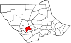
Map of
Lycoming County, Pennsylvania highlighting Woodward Township
273:
252:
442:, settlements throughout the Susquehanna valley were attacked by
948:
357:
Woodward
Township was formed on November 23, 1855, by dividing
1480:‡This populated place also has portions in an adjacent county
540:, the state capital, is 91 miles (146 km) to the south.
1026:
730:
528:
crosses the southern part of the township as it travels the
407:
in 1770. He arrived in Philadelphia and from there moved to
376:
When Woodward Township was first settled by migrants from
908:
446:
and Native Americans allied with the British. After the
861:"2007 General Highway Map Lycoming County Pennsylvania"
16:
For other Pennsylvania townships of the same name, see
758:
756:
754:
752:
700:
698:
57:
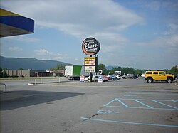
The Harvest Moon is a Woodward Township landmark on
1475:
1457:
1357:
1318:
1095:
1037:
1008:
301:
290:
280:
263:
246:
238:
230:
217:
212:
204:
196:
188:
180:
175:
167:
159:
147:
135:
125:
30:
411:. He joined with other pioneers and followed the
334:, United States. The population was 2,043 at the
824:(1st ed.). Chicago: Brown, Runk & Co.
815:"Old Lycoming, Anthony, Woodward, and Lycoming"
960:
8:
765:"City and Town Population Totals: 2020-2021"
1520:Townships in Lycoming County, Pennsylvania
967:
953:
945:
663:of any race were 0.17% of the population.
554:
27:
808:
806:
450:in the summer of 1778 (near what is now
694:
300:
279:
245:
211:
203:
174:
158:
124:
89:
65:
49:
25:Township in Pennsylvania, United States
792:
782:
574:
725:
723:
380:it was outside the boundaries of the
289:
262:
237:
229:
216:
195:
192:12.98 sq mi (33.62 km)
187:
184:13.54 sq mi (35.07 km)
179:
166:
146:
134:
77:
7:
1525:Populated places established in 1772
655:, and 0.58% from two or more races.
85:Map of Lycoming County, Pennsylvania
1530:1772 establishments in Pennsylvania
200:0.56 sq mi (1.45 km)
975:Municipalities and communities of
887:"Census of Population and Housing"
564:
454:) and smaller local attacks, the "
448:Wyoming Valley battle and massacre
14:
813:Meginness, John Franklin (1892).
223:
222:
79:
67:
51:
735:United States Geological Survey
482:during the construction of the
18:Woodward Township, Pennsylvania
731:"US Board on Geographic Names"
422:West Branch Susquehanna Valley
395:Brattan Caldwell, a native of
1:
978:Lycoming County, Pennsylvania
708:. United States Census Bureau
530:West Branch Susquehanna River
512:West Branch Susquehanna River
347:Metropolitan Statistical Area
242:166.91/sq mi (64.45/km)
913:United States Census Bureau
706:"2016 U.S. Gazetteer Files"
545:United States Census Bureau
231: • Estimate
1546:
15:
1485:
1024:
989:
623:
610:
595:
580:
573:
568:
563:
560:
518:south of the river), and
502:at the northeast corner,
90:
78:
66:
50:
41:
462:, then further south to
382:Province of Pennsylvania
208:768 ft (234 m)
675:there were 99.3 males.
1031:
473:Treaty of Fort Stanwix
1030:
909:"U.S. Census website"
624:U.S. Decennial Census
556:Historical population
504:Old Lycoming Township
468:Sullivan's Expedition
426:Northumberland County
369:for Williamsport and
338:, down from 2,200 in
265: • Summer (
110:41.22972°N 77.14389°W
1498:United States portal
516:Susquehanna Township
429:justice of the peace
342:. It is part of the
239: • Density
1491:Pennsylvania portal
763:Bureau, US Census.
557:
514:to the south (with
420:. This part of the
115:41.22972; -77.14389
106: /
1087:South Williamsport
1032:
795:has generic name (
771:. US Census Bureau
737:. October 25, 2007
555:
484:Pennsylvania Canal
418:Nippenose Township
403:, migrated to the
218: • Total
197: • Water
181: • Total
32:Woodward Township,
1507:
1506:
680:per capita income
628:
627:
543:According to the
510:to the east, the
500:Lycoming Township
440:Revolutionary War
413:Susquehanna River
405:Thirteen Colonies
320:Woodward Township
317:
316:
307:woodward-township
189: • Land
1537:
1499:
1492:
1029:
1001:
994:
984:
979:
969:
962:
955:
946:
941:
940:
938:Official website
924:
923:
921:
919:
905:
899:
898:
896:
894:
883:
877:
876:
874:
872:
866:
856:
850:
849:
840:
838:
810:
801:
800:
794:
790:
788:
780:
778:
776:
760:
747:
746:
744:
742:
727:
718:
717:
715:
713:
702:
641:African American
576:
571:
566:
558:
506:and the city of
496:Anthony Township
409:Lancaster County
359:Anthony Township
313:
310:
308:
270:
226:
225:
121:
120:
118:
117:
116:
111:
107:
104:
103:
102:
99:
83:
71:
55:
34:Lycoming County,
28:
1545:
1544:
1540:
1539:
1538:
1536:
1535:
1534:
1510:
1509:
1508:
1503:
1497:
1490:
1481:
1471:
1453:
1360:
1353:
1314:
1290:Upper Fairfield
1270:Plunketts Creek
1091:
1033:
1027:
1022:
1004:
999:
992:
985:
982:
977:
973:
936:
935:
932:
927:
917:
915:
907:
906:
902:
892:
890:
885:
884:
880:
870:
868:
864:
858:
857:
853:
836:
834:
832:
812:
811:
804:
791:
781:
774:
772:
762:
761:
750:
740:
738:
729:
728:
721:
711:
709:
704:
703:
696:
692:
668:married couples
645:Native American
569:
553:
492:
365:and serve as a
355:
328:Lycoming County
305:
264:
114:
112:
108:
105:
100:
97:
95:
93:
92:
86:
74:
62:
46:
37:
35:
33:
26:
21:
12:
11:
5:
1543:
1541:
1533:
1532:
1527:
1522:
1512:
1511:
1505:
1504:
1502:
1501:
1494:
1486:
1483:
1482:
1479:
1477:
1473:
1472:
1470:
1469:
1463:
1461:
1455:
1454:
1452:
1451:
1446:
1441:
1439:Roaring Branch
1436:
1431:
1426:
1421:
1416:
1411:
1406:
1401:
1396:
1391:
1386:
1381:
1376:
1371:
1365:
1363:
1359:Unincorporated
1355:
1354:
1352:
1351:
1345:
1340:
1335:
1330:
1324:
1322:
1316:
1315:
1313:
1312:
1307:
1302:
1297:
1292:
1287:
1282:
1277:
1272:
1267:
1262:
1257:
1252:
1247:
1242:
1237:
1232:
1227:
1222:
1217:
1212:
1207:
1202:
1197:
1192:
1187:
1182:
1177:
1172:
1167:
1162:
1157:
1152:
1147:
1142:
1137:
1132:
1127:
1122:
1117:
1112:
1107:
1101:
1099:
1093:
1092:
1090:
1089:
1084:
1079:
1074:
1069:
1064:
1059:
1054:
1049:
1043:
1041:
1035:
1034:
1025:
1023:
1021:
1020:
1014:
1012:
1006:
1005:
990:
987:
986:
974:
972:
971:
964:
957:
949:
943:
942:
931:
930:External links
928:
926:
925:
900:
878:
851:
830:
802:
748:
719:
693:
691:
688:
626:
625:
621:
620:
617:
615:
612:
608:
607:
604:
602:
599:
593:
592:
589:
587:
584:
578:
577:
572:
567:
562:
552:
549:
526:U.S. Route 220
520:Piatt Township
498:to the north,
491:
488:
433:Lycoming Creek
397:County Kildare
363:U.S. Route 220
354:
351:
315:
314:
303:
299:
298:
295:
288:
287:
284:
278:
277:
271:
261:
260:
250:
244:
243:
240:
236:
235:
232:
228:
227:
219:
215:
214:
210:
209:
206:
202:
201:
198:
194:
193:
190:
186:
185:
182:
178:
177:
173:
172:
169:
165:
164:
161:
157:
156:
151:
145:
144:
139:
133:
132:
129:
123:
122:
88:
87:
84:
76:
75:
72:
64:
63:
59:U.S. Route 220
56:
48:
47:
42:
39:
38:
31:
24:
13:
10:
9:
6:
4:
3:
2:
1542:
1531:
1528:
1526:
1523:
1521:
1518:
1517:
1515:
1500:
1495:
1493:
1488:
1487:
1484:
1478:
1474:
1468:
1465:
1464:
1462:
1460:
1456:
1450:
1447:
1445:
1442:
1440:
1437:
1435:
1432:
1430:
1427:
1425:
1422:
1420:
1417:
1415:
1412:
1410:
1407:
1405:
1402:
1400:
1397:
1395:
1392:
1390:
1387:
1385:
1382:
1380:
1377:
1375:
1372:
1370:
1367:
1366:
1364:
1362:
1356:
1349:
1346:
1344:
1341:
1339:
1336:
1334:
1331:
1329:
1326:
1325:
1323:
1321:
1317:
1311:
1308:
1306:
1303:
1301:
1298:
1296:
1293:
1291:
1288:
1286:
1283:
1281:
1278:
1276:
1273:
1271:
1268:
1266:
1263:
1261:
1258:
1256:
1253:
1251:
1248:
1246:
1243:
1241:
1238:
1236:
1233:
1231:
1228:
1226:
1223:
1221:
1218:
1216:
1213:
1211:
1208:
1206:
1203:
1201:
1198:
1196:
1193:
1191:
1188:
1186:
1183:
1181:
1178:
1176:
1173:
1171:
1168:
1166:
1163:
1161:
1158:
1156:
1153:
1151:
1148:
1146:
1143:
1141:
1138:
1136:
1133:
1131:
1128:
1126:
1123:
1121:
1118:
1116:
1113:
1111:
1108:
1106:
1103:
1102:
1100:
1098:
1094:
1088:
1085:
1083:
1080:
1078:
1077:Picture Rocks
1075:
1073:
1070:
1068:
1067:Montoursville
1065:
1063:
1060:
1058:
1055:
1053:
1050:
1048:
1045:
1044:
1042:
1040:
1036:
1019:
1016:
1015:
1013:
1011:
1007:
1003:
1002:
995:
988:
983:United States
980:
970:
965:
963:
958:
956:
951:
950:
947:
939:
934:
933:
929:
914:
910:
904:
901:
888:
882:
879:
863:
862:
855:
852:
848:
846:
833:
831:0-7884-0428-8
827:
823:
822:
816:
809:
807:
803:
798:
786:
770:
766:
759:
757:
755:
753:
749:
736:
732:
726:
724:
720:
707:
701:
699:
695:
689:
687:
685:
681:
676:
672:
669:
664:
662:
658:
654:
651:, 0.08% from
650:
646:
642:
638:
633:
622:
618:
616:
613:
609:
605:
603:
600:
598:
594:
590:
588:
585:
583:
579:
559:
550:
548:
546:
541:
539:
535:
531:
527:
523:
521:
517:
513:
509:
505:
501:
497:
489:
487:
485:
481:
476:
474:
469:
465:
461:
457:
453:
449:
445:
441:
436:
434:
430:
427:
423:
419:
414:
410:
406:
402:
398:
393:
391:
390:Fair Play Men
387:
383:
379:
374:
372:
368:
364:
360:
352:
350:
348:
345:
341:
337:
333:
329:
325:
321:
312:
304:
296:
293:
285:
283:
275:
272:
268:
258:
257:Eastern (EST)
254:
251:
249:
241:
233:
220:
207:
199:
191:
183:
170:
162:
155:
152:
150:
143:
140:
138:
131:United States
130:
128:
119:
91:Coordinates:
82:
70:
60:
54:
45:
40:
29:
23:
19:
1404:Jersey Mills
1309:
1250:Old Lycoming
1082:Salladasburg
1057:Jersey Shore
1018:Williamsport
1000:Williamsport
997:
916:. Retrieved
903:
891:. Retrieved
889:. Census.gov
881:
871:December 26,
869:. Retrieved
860:
854:
842:
835:. Retrieved
819:
793:|last1=
773:. Retrieved
768:
739:. Retrieved
710:. Retrieved
684:poverty line
677:
673:
665:
629:
551:Demographics
542:
534:Jersey Shore
524:
508:Williamsport
493:
477:
452:Wilkes-Barre
437:
394:
386:Philadelphia
375:
371:Jersey Shore
356:
344:Williamsport
332:Pennsylvania
319:
318:
286:42-081-86456
168:Incorporated
142:Pennsylvania
36:Pennsylvania
22:
1409:Lairdsville
1374:Balls Mills
1361:communities
1333:Garden View
1285:Susquehanna
1240:Muncy Creek
1140:Cogan House
1052:Hughesville
993:County seat
918:January 31,
741:January 31,
653:other races
611:2021 (est.)
480:shanty town
456:Big Runaway
336:2020 census
113: /
1514:Categories
1459:Ghost town
1449:Unityville
1399:Hoppestown
1369:Antes Fort
1295:Washington
1280:Shrewsbury
1225:Mill Creek
1062:Montgomery
1047:Duboistown
769:Census.gov
712:August 14,
690:References
630:As of the
538:Harrisburg
294:feature ID
213:Population
98:41°13′47″N
1476:Footnotes
1444:Slate Run
1424:Pennsdale
1389:Cedar Run
1348:Rauchtown
1245:Nippenose
1195:Loyalsock
1190:Limestone
1155:Fairfield
1110:Armstrong
1097:Townships
837:April 21,
490:Geography
444:Loyalists
282:FIPS code
248:Time zone
205:Elevation
101:77°8′38″W
1379:Barbours
1310:Woodward
1230:Moreland
1210:McIntyre
1200:Lycoming
1160:Franklin
1145:Cummings
1115:Bastress
1039:Boroughs
785:cite web
775:July 15,
657:Hispanic
647:, 0.17%
643:, 0.17%
639:, 0.75%
324:township
154:Lycoming
44:Township
1434:Ralston
1429:Proctor
1394:Chemung
1220:Mifflin
1205:McHenry
1175:Jackson
1170:Hepburn
1135:Clinton
1130:Cascade
1105:Anthony
893:June 4,
847:typos).
464:Sunbury
438:In the
401:Ireland
353:History
302:Website
297:1216778
160:Settled
127:Country
1467:Masten
1419:Nisbet
1414:Linden
1384:Cammal
1338:Kenmar
1300:Watson
1275:Porter
1215:McNett
1180:Jordan
1165:Gamble
1150:Eldred
828:
661:Latino
632:census
561:Census
378:Europe
367:suburb
221:2,043
149:County
1328:Faxon
1260:Piatt
1235:Muncy
1185:Lewis
1125:Brown
1120:Brady
1072:Muncy
865:(PDF)
649:Asian
637:White
619:−0.5%
614:2,033
606:−7.1%
601:2,043
586:2,200
460:Muncy
322:is a
276:(EDT)
274:UTC-4
253:UTC-5
234:2,033
137:State
1343:Oval
1320:CDPs
1305:Wolf
1265:Pine
1255:Penn
1010:City
920:2008
895:2016
873:2009
839:2007
826:ISBN
797:help
777:2022
743:2008
714:2017
597:2020
582:2010
570:Note
565:Pop.
340:2010
311:.biz
309:.hub
292:GNIS
176:Area
171:1855
163:1772
845:OCR
659:or
326:in
267:DST
1516::
996::
981:,
911:.
841:.
817:.
805:^
789::
787:}}
783:{{
767:.
751:^
733:.
722:^
697:^
575:%±
536:.
475:.
435:.
399:,
373:.
349:.
330:,
1350:‡
968:e
961:t
954:v
922:.
897:.
875:.
799:)
779:.
745:.
716:.
591:—
269:)
259:)
255:(
61:.
20:.
Text is available under the Creative Commons Attribution-ShareAlike License. Additional terms may apply.