62:
79:
840:
104:
851:
111:
86:
269:
The historic town center stretches for about two miles along Main Street, with branching elements along some of the side streets. Its northernmost extent is
Flanders Road, and its southern end is at Old Sherman Hill Road. In an area of more than 200 acres (81 ha), there are 161 historically
265:
people. The early settlement was made along a long-standing Native
American trail, now roughly followed by Main Street. It was incorporated in 1674, and was the mother town for several surrounding communities, achieving its present municipal bounds by 1807. It was a prosperous agricultural
729:
895:
824:
760:
744:
900:
293:
734:
819:
765:
249:), from Flanders Road in the north to Old Sherman Hill Road in the south, the district represents an architectural cross section of the town history, from the late 17th century to the present. It was added to the
406:
786:
688:
719:
653:
618:
693:
598:
558:
383:
890:
658:
648:
643:
623:
739:
573:
488:
608:
603:
478:
698:
663:
568:
543:
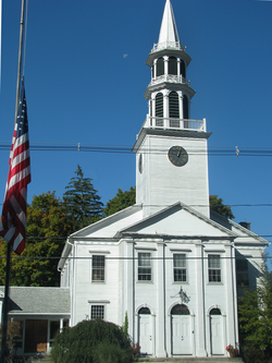
278:. There are nine churches in the district, including three Federal style buildings erected before 1820. The visually most prominent is the Roman Catholic church, which was built in 1902.
683:
633:
613:
588:
578:
563:
553:
538:
518:
493:
483:
473:
703:
678:
583:
523:
503:
498:
468:
458:
638:
593:
533:
508:
463:
770:
668:
548:
513:
724:
673:
628:
528:
885:
875:
436:
421:
270:
significant buildings. About half were built before 1830, including thirteen that were built before 1740. The oldest buildings, houses and barns, date to the 1680s. The
376:
452:
144:
78:
880:
854:
369:
103:
910:
844:
416:
48:
61:
392:
321:
250:
39:
271:
807:
287:
275:
905:
812:
791:
266:
community in the 18th and early 19th century, the period to which much of the town center's architecture dates.
426:
431:
411:
326:
246:
242:
132:
274:, built in 1740, is also historically important as the site of an early foundational meeting of the
343:
361:
261:
The town of
Woodbury was settled by colonists in 1673, having purchased its land from the
221:
869:
825:
University and college buildings listed on the
National Register of Historic Places
294:
National
Register of Historic Places listings in Litchfield County, Connecticut
896:
Historic districts on the
National Register of Historic Places in Connecticut
159:
146:
262:
901:
National
Register of Historic Places in Litchfield County, Connecticut
820:
List of jails and prisons on the
National Register of Historic Places
316:
365:
131:
Both sides of Main St. (U.S. 6) for 2 mi., radiating rds.,
290:, located along Main Street south of the commercial area
110:
85:
344:"NRHP nomination for Woodbury Historic District No. 1"
891:
Historic districts in
Litchfield County, Connecticut
800:
779:
753:
712:
445:
422:
History of the
National Register of Historic Places
399:
227:
214:
206:
198:
183:
175:
138:
127:
210:Mid 19th Century Revival, Early Republic, Colonial
453:List of U.S. National Historic Landmarks by state
845:National Register of Historic Places portal
16:Historic district in Connecticut, United States
377:
245:. Extending along two miles of Main Street (
8:
886:Buildings and structures completed in 1680
876:Colonial architecture in the United States
384:
370:
362:
60:
393:U.S. National Register of Historic Places
40:U.S. National Register of Historic Places
305:
338:
336:
317:"National Register Information System"
311:
309:
241:encompasses the linear town center of
23:
7:
881:Georgian architecture in Connecticut
322:National Register of Historic Places
251:National Register of Historic Places
66:United Methodist Church in Woodbury
911:1680 establishments in Connecticut
808:National Historic Preservation Act
14:
850:
849:
838:
288:Woodbury Historic District No. 2
239:Woodbury Historic District No. 1
109:
102:
84:
77:
32:Woodbury Historic District No. 1
761:Federated States of Micronesia
407:Architectural style categories
216:
1:
118:Show map of the United States
21:United States historic place
927:
813:Historic Preservation Fund
792:American Legation, Morocco
833:
754:Lists by associated state
215:NRHP reference
71:
59:
55:
46:
37:
30:
26:
735:Northern Mariana Islands
207:Architectural style
346:. National Park Service
257:Description and history
93:Show map of Connecticut
730:Minor Outlying Islands
713:Lists by insular areas
427:Keeper of the Register
179:200 acres (81 ha)
49:U.S. Historic district
906:Woodbury, Connecticut
432:National Park Service
412:Contributing property
327:National Park Service
247:United States Route 6
243:Woodbury, Connecticut
160:41.54417°N 73.20861°W
133:Woodbury, Connecticut
787:District of Columbia
253:on March 11, 1971.
165:41.54417; -73.20861
156: /
863:
862:
417:Historic district
235:
234:
918:
853:
852:
843:
842:
841:
766:Marshall Islands
386:
379:
372:
363:
356:
355:
353:
351:
340:
331:
330:
313:
276:Episcopal Church
218:
194:
192:
171:
170:
168:
167:
166:
161:
157:
154:
153:
152:
149:
119:
113:
112:
106:
94:
88:
87:
81:
64:
24:
926:
925:
921:
920:
919:
917:
916:
915:
866:
865:
864:
859:
839:
837:
829:
796:
775:
749:
708:
441:
395:
390:
360:
359:
349:
347:
342:
341:
334:
329:. July 9, 2010.
315:
314:
307:
302:
284:
259:
190:
188:
164:
162:
158:
155:
150:
147:
145:
143:
142:
123:
122:
121:
120:
117:
116:
115:
114:
97:
96:
95:
92:
91:
90:
89:
67:
51:
42:
33:
22:
17:
12:
11:
5:
924:
922:
914:
913:
908:
903:
898:
893:
888:
883:
878:
868:
867:
861:
860:
858:
857:
847:
834:
831:
830:
828:
827:
822:
817:
816:
815:
804:
802:
798:
797:
795:
794:
789:
783:
781:
777:
776:
774:
773:
768:
763:
757:
755:
751:
750:
748:
747:
745:Virgin Islands
742:
737:
732:
727:
722:
720:American Samoa
716:
714:
710:
709:
707:
706:
701:
696:
691:
686:
681:
676:
671:
666:
661:
656:
654:South Carolina
651:
646:
641:
636:
631:
626:
621:
619:North Carolina
616:
611:
606:
601:
596:
591:
586:
581:
576:
571:
566:
561:
556:
551:
546:
541:
536:
531:
526:
521:
516:
511:
506:
501:
496:
491:
486:
481:
476:
471:
466:
461:
456:
449:
447:
446:Lists by state
443:
442:
440:
439:
437:Property types
434:
429:
424:
419:
414:
409:
403:
401:
397:
396:
391:
389:
388:
381:
374:
366:
358:
357:
332:
304:
303:
301:
298:
297:
296:
291:
283:
280:
258:
255:
233:
232:
231:March 11, 1971
229:
225:
224:
219:
212:
211:
208:
204:
203:
200:
196:
195:
185:
181:
180:
177:
173:
172:
140:
136:
135:
129:
125:
124:
108:
107:
101:
100:
99:
98:
83:
82:
76:
75:
74:
73:
72:
69:
68:
65:
57:
56:
53:
52:
47:
44:
43:
38:
35:
34:
31:
28:
27:
20:
15:
13:
10:
9:
6:
4:
3:
2:
923:
912:
909:
907:
904:
902:
899:
897:
894:
892:
889:
887:
884:
882:
879:
877:
874:
873:
871:
856:
848:
846:
836:
835:
832:
826:
823:
821:
818:
814:
811:
810:
809:
806:
805:
803:
799:
793:
790:
788:
785:
784:
782:
778:
772:
769:
767:
764:
762:
759:
758:
756:
752:
746:
743:
741:
738:
736:
733:
731:
728:
726:
723:
721:
718:
717:
715:
711:
705:
702:
700:
697:
695:
694:West Virginia
692:
690:
687:
685:
682:
680:
677:
675:
672:
670:
667:
665:
662:
660:
657:
655:
652:
650:
647:
645:
642:
640:
637:
635:
632:
630:
627:
625:
622:
620:
617:
615:
612:
610:
607:
605:
602:
600:
599:New Hampshire
597:
595:
592:
590:
587:
585:
582:
580:
577:
575:
572:
570:
567:
565:
562:
560:
559:Massachusetts
557:
555:
552:
550:
547:
545:
542:
540:
537:
535:
532:
530:
527:
525:
522:
520:
517:
515:
512:
510:
507:
505:
502:
500:
497:
495:
492:
490:
487:
485:
482:
480:
477:
475:
472:
470:
467:
465:
462:
460:
457:
454:
451:
450:
448:
444:
438:
435:
433:
430:
428:
425:
423:
420:
418:
415:
413:
410:
408:
405:
404:
402:
398:
394:
387:
382:
380:
375:
373:
368:
367:
364:
345:
339:
337:
333:
328:
324:
323:
318:
312:
310:
306:
299:
295:
292:
289:
286:
285:
281:
279:
277:
273:
267:
264:
256:
254:
252:
248:
244:
240:
230:
228:Added to NRHP
226:
223:
220:
213:
209:
205:
201:
197:
186:
182:
178:
174:
169:
141:
137:
134:
130:
126:
105:
80:
70:
63:
58:
54:
50:
45:
41:
36:
29:
25:
19:
659:South Dakota
649:Rhode Island
644:Pennsylvania
624:North Dakota
348:. Retrieved
320:
268:
260:
238:
236:
18:
780:Other areas
740:Puerto Rico
574:Mississippi
489:Connecticut
272:Glebe House
163: /
139:Coordinates
870:Categories
689:Washington
609:New Mexico
604:New Jersey
479:California
300:References
151:73°12′31″W
148:41°32′39″N
699:Wisconsin
664:Tennessee
569:Minnesota
544:Louisiana
350:March 26,
855:Category
684:Virginia
634:Oklahoma
614:New York
589:Nebraska
579:Missouri
564:Michigan
554:Maryland
539:Kentucky
519:Illinois
494:Delaware
484:Colorado
474:Arkansas
282:See also
263:Potatuck
222:71000908
202:Multiple
199:Built by
128:Location
801:Related
704:Wyoming
679:Vermont
584:Montana
524:Indiana
504:Georgia
499:Florida
469:Arizona
459:Alabama
189: (
639:Oregon
594:Nevada
534:Kansas
509:Hawaii
464:Alaska
400:Topics
771:Palau
669:Texas
549:Maine
514:Idaho
184:Built
725:Guam
674:Utah
629:Ohio
529:Iowa
352:2017
237:The
191:1680
187:1680
176:Area
217:No.
872::
335:^
325:.
319:.
308:^
455::
385:e
378:t
371:v
354:.
193:)
Text is available under the Creative Commons Attribution-ShareAlike License. Additional terms may apply.