149:
368:
133:
27:
156:
394:
The town of
Brushgrove was once a major trading hub for timber, sugar and other agriculture goods due to its location on the Clarence River. This brought tremendous wealth to area and at one time the island supported many schools, a police station, many businesses and other utilities. However, due to
426:
The island is broken up into areas being- Woodford Dale (The last school on the island which closed in 2011) Woodford Leigh
Brushgrove (Old, police station, post office, pub, shops) Ilarwill ( aboriginal village, old quarry boat shed) Tyndale South arm As well as many of property name like yakalo
363:
There are approximately 300 people living on the island. Through its almost exact centre is a mountain ridge. The rest is plains which are subjected to periodic flooding. The largest town is
Brushgrove at the south of the island. It holds major aboriginal significance in the area and the aboriginal
441:
The
Woodford Island nature reserve (proclaimed in 1999) protects only a small part of the island, largely the higher elevation areas along the Woodford Island Ridge, and protects dry forest as well as providing habitat for threatened animal species.
525:
355:
and milk producing cattle. A small fishing fleet plies the
Clarence River. There are a few small businesses, however, most residents travel off the island to Maclean or Grafton for goods and services.
148:
380:
Woodford Island was one of the first places inhabited by
Europeans on the Far-North Coast. Original settler John Small was attracted to the abundance of
332:
There are three ways on and off the island, two bridges; at the southern end is the
Wingfield Bridge in Brushgrove, which crosses to Cowper, and the
433:
Hermitt Cave, Small's
Pioneer Cemetery, Old Schools, Abandoned Quarry. Police station. Radio towers. Cane fields. And the mighty Clarence River
416:
420:
187:
638:
633:
110:
313:
285:
258:
44:
605:
91:
48:
63:
70:
317:
367:
478:
404:
340:
77:
499:
412:
321:
59:
37:
485:
464:
492:
457:
579:
395:
the development of road and train infrastructure, the town has dwindled in size over the past century.
275:
554:
450:
391:(original inhabitants of Woodford Island) were murdered by cedar getters in a reprisal massacre.
388:
84:
408:
333:
132:
304:
is the largest island in the lower reaches of the
Clarence River in the Far-North Coast of
471:
305:
238:
445:
Threatened and vulnerable plant species found or predicted to be found in the reserve:
627:
26:
351:
Woodford Island is mostly flood plain which supports the primary industries of
352:
324:. The island is the largest in NSW, either inland or offshore, at 37 km.
202:
189:
309:
250:
226:
316:
where it splits into the South Arm and North Arm at the small village of
289:
262:
381:
366:
555:"Centre For 21st Century Humanities: Woodford Island massacre"
20:
403:
Tourist drive 22 travels across the island starting at the
137:
Map of the
Clarence River showing Woodford Island in 1886
343:
to Woodford Dale, being the western side of the island,
526:"Woodford Island Nature Reserve plan of management"
336:at the northern end, that gives access to Maclean.
272:
249:
244:
234:
218:
181:
176:
51:. Unsourced material may be challenged and removed.
606:"McFarlane Bridge, Clarence River, Maclean, 1906"
430:Maclean District Golf Course is on the island.
8:
125:
131:
124:
111:Learn how and when to remove this message
512:
155:
16:Locality in New South Wales, Australia
7:
520:
518:
516:
421:New South Wales Legislative Assembly
49:adding citations to reliable sources
427:on the Lawrence side of the island
14:
584:Tasmanian Timber Promotion Board
154:
147:
25:
415:. . The bridge was named after
339:There is a ferry that connects
36:needs additional citations for
437:Woodford Island Nature Reserve
1:
479:Paspalidium grandispiculatum
407:Car Ferry and ending at the
320:then reforms at the town of
168:Location in New South Wales
655:
639:River islands of Australia
634:Islands of New South Wales
533:www.environment.nsw.gov.au
500:Leucopogon recurvicepalus
223:
142:
130:
586:. University of Tasmania
559:c21ch.newcastle.edu.au
486:Callistemon acuminatus
465:Eucalyptus tetrapleura
372:
312:. It is formed by the
245:Additional information
608:. Engineers Australia
458:Eucalyptus psammitica
370:
364:village of Ilarwill.
274: • Summer (
419:local member of the
359:People and geography
45:improve this article
399:Points of interests
382:Australian Redcedar
199: /
127:
580:"McFarlane Bridge"
493:Melichrus hirsutus
387:In 1838, some 20
373:
203:29.517°S 153.133°E
389:Bandjalung people
299:
298:
121:
120:
113:
95:
60:"Woodford Island"
646:
618:
617:
615:
613:
602:
596:
595:
593:
591:
576:
570:
569:
567:
565:
551:
545:
544:
542:
540:
530:
522:
451:Marsdenia liisae
409:McFarlane Bridge
334:McFarlane Bridge
279:
214:
213:
211:
210:
209:
208:-29.517; 153.133
204:
200:
197:
196:
195:
192:
158:
157:
151:
135:
128:
116:
109:
105:
102:
96:
94:
53:
29:
21:
654:
653:
649:
648:
647:
645:
644:
643:
624:
623:
622:
621:
611:
609:
604:
603:
599:
589:
587:
578:
577:
573:
563:
561:
553:
552:
548:
538:
536:
528:
524:
523:
514:
509:
472:Angophora robur
439:
401:
378:
371:Woodford Island
361:
349:
330:
306:New South Wales
302:Woodford Island
295:
273:
268:
239:New South Wales
230:
207:
205:
201:
198:
193:
190:
188:
186:
185:
172:
171:
170:
169:
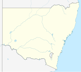
166:
165:
164:
163:
162:Woodford Island
159:
138:
126:Woodford Island
117:
106:
100:
97:
54:
52:
42:
30:
17:
12:
11:
5:
652:
650:
642:
641:
636:
626:
625:
620:
619:
597:
571:
546:
511:
510:
508:
505:
504:
503:
496:
489:
482:
475:
468:
461:
454:
438:
435:
417:John McFarlane
400:
397:
377:
374:
360:
357:
348:
345:
329:
326:
314:Clarence River
297:
296:
294:
293:
282:
280:
270:
269:
267:
266:
255:
253:
247:
246:
242:
241:
236:
232:
231:
224:
221:
220:
219:Administration
216:
215:
183:
179:
178:
174:
173:
167:
161:
160:
153:
152:
146:
145:
144:
143:
140:
139:
136:
119:
118:
33:
31:
24:
15:
13:
10:
9:
6:
4:
3:
2:
651:
640:
637:
635:
632:
631:
629:
607:
601:
598:
585:
581:
575:
572:
560:
556:
550:
547:
534:
527:
521:
519:
517:
513:
506:
502:
501:
497:
495:
494:
490:
488:
487:
483:
481:
480:
476:
474:
473:
469:
467:
466:
462:
460:
459:
455:
453:
452:
448:
447:
446:
443:
436:
434:
431:
428:
424:
422:
418:
414:
410:
406:
398:
396:
392:
390:
385:
383:
375:
369:
365:
358:
356:
354:
346:
344:
342:
337:
335:
327:
325:
323:
319:
315:
311:
307:
303:
291:
287:
284:
283:
281:
277:
271:
264:
260:
257:
256:
254:
252:
248:
243:
240:
237:
233:
229:
228:
222:
217:
212:
184:
180:
175:
150:
141:
134:
129:
123:
115:
112:
104:
101:December 2019
93:
90:
86:
83:
79:
76:
72:
69:
65:
62: –
61:
57:
56:Find sources:
50:
46:
40:
39:
34:This article
32:
28:
23:
22:
19:
610:. Retrieved
600:
588:. Retrieved
583:
574:
562:. Retrieved
558:
549:
537:. Retrieved
532:
498:
491:
484:
477:
470:
463:
456:
449:
444:
440:
432:
429:
425:
411:that enters
402:
393:
386:
379:
362:
350:
338:
331:
301:
300:
225:
122:
107:
98:
88:
81:
74:
67:
55:
43:Please help
38:verification
35:
18:
564:12 December
539:13 December
206: /
182:Coordinates
628:Categories
507:References
353:sugar cane
318:Brushgrove
71:newspapers
310:Australia
251:Time zone
227:Australia
177:Geography
612:11 March
405:Lawrence
341:Lawrence
194:153°08′E
590:21 June
413:Maclean
376:History
347:Economy
322:Maclean
191:29°31′S
85:scholar
535:. 2010
328:Access
290:UTC+11
263:UTC+10
87:
80:
73:
66:
58:
529:(PDF)
235:state
92:JSTOR
78:books
614:2015
592:2012
566:2023
541:2023
286:AEDT
259:AEST
64:news
276:DST
47:by
630::
582:.
557:.
531:.
515:^
423:.
384:.
308:,
616:.
594:.
568:.
543:.
292:)
288:(
278:)
265:)
261:(
114:)
108:(
103:)
99:(
89:·
82:·
75:·
68:·
41:.
Text is available under the Creative Commons Attribution-ShareAlike License. Additional terms may apply.