259:
28:
320:
147:
On June 23, 2015, FAA officially stopped providing the World
Aeronautical Chart due to a decline in interest and technological advances. Charts: CC–8, CC–9; CD–10, CD–11, CD–12; CE–12, CE–13, CE–15; CF–16, CF–17, CF–18, CF–19; CG–18, CG–19, CG–20, CG–21; CH–22, CH–23, and CH–24 ceased to be printed
148:
beyond
September 17, 2015. Charts: CH–25; CJ–26, and CJ–27 production ended upon their next scheduled printing dates of December 10, 2015; February 04, 2016, and March 31, 2016 respectively.
115:
Unlike sectional charts, North
American WACs are named according to an international "grid system" having a combination of letters and numbers. For example, WAC CF-16 covered the
167:
244:
198:
304:
361:
112:
airspace is covered by a set of 18 WACs. The 43 Australian WACs are indexed according to a geographic name or a corresponding 4-digit number.
202:
59:
297:
178:
380:
354:
395:
157:
172:
290:
74:, and the symbols are the same. However, there is less detail at the smaller scale, so it is seldom used for
400:
385:
347:
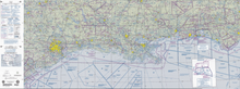
58:
of 1:1,000,000 (about 1 inch = 13.7 nautical miles or 16 statute miles). WACs were discontinued by the
135:
and increasing to the east, to a maximum of 29, depending upon the number of charts required at that
390:
234:
229:
86:. They are useful for strategic flight planning, where a view of the entire flight area is useful.
75:
162:
132:
47:
116:
54:
of moderate speed aircraft and aircraft at high altitudes in the United States. They are at a
239:
120:
83:
71:
17:
331:
274:
32:
374:
258:
108:
A set of 12 WACs covered the continental United States and 8 others covered Alaska.
27:
266:
79:
55:
124:
128:
102:
98:
319:
199:"80 FR 36035: Policy for Discontinuance of World Aeronautical Chart Series"
327:
136:
51:
109:
94:
90:
26:
235:
World 1:1mil AAF Aeronautical Charts CWHM – McMaster
University
31:
FAA World
Aeronautical Chart, showing the northern part of the
270:
230:
World 1:1mil AAF Aeronautical Charts – McMaster
University
78:
flight at slower speeds or for local flights. WACs show
335:
278:
175:(ONC), which do not show controlled airspace boundaries
89:
These charts are revised annually, except for several
245:Discontinuation of World Aeronautical Charts (WAC)
131:. The numbers generally progress from 1 at the
168:Aeronautical chart conventions (United States)
355:
298:
8:
105:WAC charts are amended every 3 to 5 years.
362:
348:
305:
291:
101:charts which are revised every 2 years.
190:
123:area. Letters progress from A at the
7:
316:
314:
255:
253:
240:Airservices Australia Online Store
25:
318:
257:
82:information, airports and radio
203:Federal Aviation Administration
60:Federal Aviation Administration
179:International Map of the World
1:
220:Source: FAA Pilot's Handbook
181:, another millionth world map
334:. You can help Knowledge by
277:. You can help Knowledge by
173:Operational navigation chart
127:to U at the southern tip of
70:These charts are similar to
417:
313:
252:
158:Index of aviation articles
40:World Aeronautical Chart
18:World Aeronautical Chart
50:used for navigation by
330:-related article is a
119:, and E-15 covers the
35:
30:
381:Aeronautical charts
76:visual flight rules
273:term article is a
163:Moving map display
133:Greenwich meridian
48:aeronautical chart
36:
396:Cartography stubs
343:
342:
286:
285:
117:Pacific Northwest
84:navigational aids
16:(Redirected from
408:
364:
357:
350:
322:
315:
307:
300:
293:
261:
254:
215:
214:
212:
210:
195:
121:British Columbia
72:sectional charts
62:(FAA) in 2015.
46:) was a type of
21:
416:
415:
411:
410:
409:
407:
406:
405:
371:
370:
369:
368:
312:
311:
250:
226:
218:
208:
206:
205:. June 23, 2015
197:
196:
192:
188:
154:
145:
93:charts and the
68:
23:
22:
15:
12:
11:
5:
414:
412:
404:
403:
401:Aviation stubs
398:
393:
388:
386:Air navigation
383:
373:
372:
367:
366:
359:
352:
344:
341:
340:
323:
310:
309:
302:
295:
287:
284:
283:
262:
248:
247:
242:
237:
232:
225:
224:External links
222:
217:
216:
189:
187:
184:
183:
182:
176:
170:
165:
160:
153:
150:
144:
143:Discontinuance
141:
67:
64:
33:Gulf of Mexico
24:
14:
13:
10:
9:
6:
4:
3:
2:
413:
402:
399:
397:
394:
392:
389:
387:
384:
382:
379:
378:
376:
365:
360:
358:
353:
351:
346:
345:
339:
337:
333:
329:
324:
321:
317:
308:
303:
301:
296:
294:
289:
288:
282:
280:
276:
272:
268:
263:
260:
256:
251:
246:
243:
241:
238:
236:
233:
231:
228:
227:
223:
221:
204:
200:
194:
191:
185:
180:
177:
174:
171:
169:
166:
164:
161:
159:
156:
155:
151:
149:
142:
140:
138:
134:
130:
126:
122:
118:
113:
111:
106:
104:
100:
96:
92:
87:
85:
81:
77:
73:
65:
63:
61:
57:
53:
49:
45:
41:
34:
29:
19:
336:expanding it
325:
279:expanding it
264:
249:
219:
207:. Retrieved
193:
146:
114:
107:
88:
69:
43:
39:
37:
267:cartography
209:18 February
80:topographic
66:Description
391:World maps
375:Categories
186:References
125:north pole
103:Australian
129:Argentina
99:Caribbean
328:aviation
152:See also
137:latitude
110:Canadian
271:mapping
95:Mexican
91:Alaskan
52:pilots
326:This
265:This
56:scale
332:stub
275:stub
211:2024
269:or
44:WAC
377::
201:.
139:.
38:A
363:e
356:t
349:v
338:.
306:e
299:t
292:v
281:.
213:.
97:/
42:(
20:)
Text is available under the Creative Commons Attribution-ShareAlike License. Additional terms may apply.