140:
540:) with hot summers and cool winters. Precipitation is significant throughout the year, but is somewhat lower in winter. The average annual temperature in Yufu is 13.3 °C (55.9 °F). The average annual rainfall is 1,992.2 mm (78.43 in) with June as the wettest month. The temperatures are highest on average in August, at around 24.5 °C (76.1 °F), and lowest in January, at around 2.3 °C (36.1 °F). The highest temperature ever recorded in Yufu was 35.9 °C (96.6 °F) on 10 August 2013; the coldest temperature ever recorded was −13.2 °C (8.2 °F) on 3 February 2012.
1831:
1629:
127:
1877:
105:
1777:
95:
1619:
1609:
1554:
1398:
73:
421:
369:
147:
448:, forms one of the central watersheds in Kyushu, separating the Ōita River water system on the Yufu City side and the Chikugo River water system on the Kokonoe Town side. There are five hot springs located throughout the city, including the nationally famous Yufuin Onsen, and most of the city has been designated as the
439:
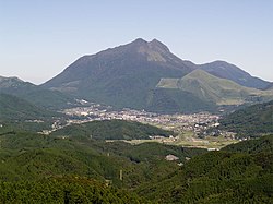
of the Ōita River that flows through the center of the city, with the former Yufuin Town near the headwaters and Yufuin Basin, the former Shōnai Town on the left and right of the river terraces in the middle, and the former Hasama Town on the downstream and plain areas. Some areas of the former
1367:
were established on May 1, 1889 with the creation of the modern municipalities system. The two villages merged to form Yufuin
Village on April 1, 1936, which was raised to town status on April 1, 1948. The city of Yufu was established on October 1, 2005, from the merger of the towns of
434:
Yufu is located almost in the center of Ōita
Prefecture, with high mountains such as Mt. Yufudake (1583 meters) and Mt. Jogatake in the north, and Mt. Kurodake, Mt. Hanamure, and Mt. Toki in the south. The urban area is concentrated near the flatland formed by the
1538:
Yufu has ten public elementary schools and three public junior high schools operated by the city government, and one public high school operated by the Ōita
Prefectural Board of Education. The prefecture operates one special education school for the handicapped.
1485:
1955: Yufuin and
Yunohira are merged. The new town is named Yufuin, but the character for "Yu" is different from the one before. In the same year, Shōnai village is renamed Shōnai town and Hasama village is renamed Hasama
1482:
1954: Hasama, Tani, Yufugawa, and
Iwakigawa is merged, now named Hasama village. A month later, Anan, Asono, Higashishōnai, Minamishōnai, and Nishishōnai are united. It is named Shōnai village.
1702:
1732:
139:
1506:
city council of 20 members. Yufu contributes two members to the Ōita
Prefectural Assembly. In terms of national politics, the city is part of the
1830:
2033:
2014:
171:
1459:
1889: Villages Anan, Higashishōnai, Nishishōnai, Minamishōnai, Asono, Tani, Yufugawa, Yunohira, Iwakigawa, and Hasama are created in
1511:
1445:
1979:
534:
294:
1820:
1423:
72:
1133:
Per
Japanese census data, the population of Yufu in 2020 is 32,772 people. Yufu has been conducting censuses since 1920.
1876:
1738:
1708:
1119:
1579:
1408:
126:
1798:
1427:
1412:
104:
1848:
530:
441:
299:
1460:
1381:
1632:
1622:
445:
211:
1967:
1464:
1364:
2038:
1991:
1557:
1419:
336:
94:
1896:
1858:
1507:
223:
1595:
1571:
1561:
278:
1813:
1583:
1330:
1320:
409:
1984:
1834:
1612:
1373:
401:
228:
1360:
1072:
412:
of 110 persons per km. The total area of the city is 319.32 km (123.29 sq mi).
1996:
1936:
1921:
1911:
1575:
518:
493:
1591:
1326:
397:
63:
1931:
1377:
1369:
548:
508:
1776:
1946:
1926:
1866:
1843:
1567:
1344:
1312:
498:
356:
346:
32:
2027:
2001:
1906:
1806:
1587:
1515:
1499:
1340:
951:
513:
1348:
1316:
436:
1941:
1901:
503:
1397:
1761:
1503:
1356:
1352:
427:
420:
405:
274:
77:
186:
173:
1553:
368:
269:
1780:
1526:
The economy of Yufu is centered around agriculture and tourism it is many
17:
1916:
1489:
2005: Hasama, Shōnai, and Yufuin are united, the new city named Yufu.
216:
1891:
1527:
1473:
1936: Minamiyufu and
Kitayufu are merged, creating Yufuin village.
1335:
449:
419:
367:
1685:
1972:
1150:
1802:
1788:
311:
1391:
404:. As of 30 November 2023, the city had an estimated
444:. Mizuki Pass, located on the border with Kokonoe Town along
1145:
440:
Shōnai Town and former Yufuin Town have been designated as
1502:
form of government with a directly elected mayor and a
289:
302 Kakihara, Shōnai-chō, Yufu-shi, Ōita-ken 879-5498
1463:. Kitayufu, Minamiyufu, and Yunohira are created in
1960:
1884:
1857:
352:
342:
332:
305:
293:
285:
268:
260:
252:
247:
239:
234:
222:
210:
202:
43:
551:, Yufu (1991−2020 normals, extremes 1977−present)
1470:1899: Yunohira village is moved to Ōita District.
1363:, the villages of Kitayufu and Minamiyufu within
1347:both clans joined forces to fight the invading
1319:, the area was dominated by descendants of the
387:
381:
50:
1814:
8:
1479:1950: Yufuin town is moved to Ōita District.
1476:1948: Yufuin village is renamed Yufuin town.
1355:, the area was largely under the control of
1136:
1426:. Unsourced material may be challenged and
1325:of the province, the Ogami clan. After the
1821:
1807:
1799:
1727:
1725:
1552:
1135:
543:
40:
1697:
1695:
1446:Learn how and when to remove this message
1757:
1755:
1329:, the Ogami frequently clashed with the
1677:
327:
304:
292:
284:
267:
246:
243:319.32 km (123.29 sq mi)
233:
201:
166:
132:
116:
88:
69:
408:of 33,556 in 15883 households, and a
1311:The area of Yufu was part of ancient
351:
341:
331:
259:
251:
238:
221:
209:
123:
7:
1424:adding citations to reliable sources
119:Location of Yufu in Ōita Prefecture
2015:List of mergers in Ōita Prefecture
25:
1875:
1829:
1775:
1627:
1617:
1607:
1396:
145:
138:
125:
103:
93:
71:
1686:"Yufu City official statistics"
1:
535:Köppen climate classification
27:For the Japanese train named
1783:travel guide from Wikivoyage
146:
1120:Japan Meteorological Agency
1024:Average precipitation days
810:Mean daily minimum °C (°F)
670:Mean daily maximum °C (°F)
388:
2055:
1762:Yufu population statistics
1300:Yufu population statistics
1117:
546:
485:Neighboring municipalities
450:national hot spring resort
84:) is a symbol of Yufu City
26:
2034:Cities in Ōita Prefecture
2012:
1873:
1841:
1299:
1163:—
1070:
1023:
949:
879:
809:
739:
669:
599:
594:
591:
588:
585:
582:
579:
576:
573:
570:
567:
564:
561:
558:
555:
531:humid subtropical climate
382:
362:
328:
323:
319:
167:
133:
124:
117:
89:
70:
61:
51:
1980:Higashikunisaki District
1733:
1703:
1623:Higashikyushu Expressway
446:Japan National Route 210
47:
1633:National Route 210
424:Busy area of Yufu City.
264:110/km (270/sq mi)
442:Aso Kujū National Park
431:
373:
187:33.18000°N 131.42667°E
1734:観測史上1~10位の値(年間を通じての値)
1688:(in Japanese). Japan.
1365:Hayami District, Ōita
1137:Historical population
423:
371:
337:Japanese bush warbler
38:City in Kyushu, Japan
1420:improve this section
600:Record high °C (°F)
261: • Density
1138:
880:Record low °C (°F)
740:Daily mean °C (°F)
452:, Yufuin Onsenkyo.
192:33.18000; 131.42667
183: /
1704:気象庁 / 平年値(年・月ごとの値)
1528:hot spring resorts
1331:Kamakura shogunate
432:
410:population density
374:
253: • Total
240: • Total
2021:
2020:
1852:
1639:Local attractions
1508:Ōita 2nd district
1456:
1455:
1448:
1361:Meiji restoration
1343:; however in the
1304:
1303:
1125:
1124:
547:Climate data for
366:
365:
357:Japanese Blue Oak
286:City hall address
159:Location in Japan
16:(Redirected from
2046:
1879:
1846:
1833:
1823:
1816:
1809:
1800:
1795:
1792:
1791:
1789:Official website
1779:
1764:
1759:
1750:
1749:
1747:
1745:
1729:
1720:
1719:
1717:
1715:
1699:
1690:
1689:
1682:
1665:Yufu River Gorge
1631:
1630:
1621:
1620:
1611:
1610:
1562:Kyūdai Main Line
1556:
1451:
1444:
1440:
1437:
1431:
1400:
1392:
1359:. Following the
1152:
1147:
1139:
1027:
544:
489:Ōita Prefecture
395:
394:
391:
385:
384:
315:
314:
312:Official website
198:
197:
195:
194:
193:
188:
184:
181:
180:
179:
176:
149:
148:
142:
129:
107:
97:
75:
56:
55:
54:
53:
41:
21:
2054:
2053:
2049:
2048:
2047:
2045:
2044:
2043:
2024:
2023:
2022:
2017:
2008:
1968:Hayami District
1956:
1880:
1871:
1853:
1837:
1835:Ōita Prefecture
1827:
1793:
1787:
1786:
1772:
1767:
1760:
1753:
1743:
1741:
1735:
1731:
1730:
1723:
1713:
1711:
1705:
1701:
1700:
1693:
1684:
1683:
1679:
1675:
1650:Tsukahara Onsen
1641:
1628:
1618:
1613:Ōita Expressway
1608:
1604:
1550:
1545:
1536:
1524:
1496:
1465:Hayami District
1452:
1441:
1435:
1432:
1417:
1401:
1390:
1345:Sengoku periodm
1327:Kamakura period
1309:
1131:
1126:
1025:
1018:
1013:
1008:
1003:
998:
993:
988:
983:
978:
973:
968:
963:
958:
944:
939:
934:
929:
924:
919:
914:
909:
904:
899:
894:
889:
884:
874:
869:
864:
859:
854:
849:
844:
839:
834:
829:
824:
819:
814:
804:
799:
794:
789:
784:
779:
774:
769:
764:
759:
754:
749:
744:
734:
729:
724:
719:
714:
709:
704:
699:
694:
689:
684:
679:
674:
664:
659:
654:
649:
644:
639:
634:
629:
624:
619:
614:
609:
604:
527:
487:
474:
458:
425:
418:
402:Ōita Prefecture
392:
379:
310:
309:
191:
189:
185:
182:
177:
174:
172:
170:
169:
163:
162:
161:
160:
157:
156:
155:
154:
150:
120:
113:
112:
111:
110:
101:
100:
85:
66:
57:
49:
48:
46:
39:
36:
23:
22:
15:
12:
11:
5:
2052:
2050:
2042:
2041:
2036:
2026:
2025:
2019:
2018:
2013:
2010:
2009:
2007:
2006:
2005:
2004:
1999:
1989:
1988:
1987:
1977:
1976:
1975:
1964:
1962:
1958:
1957:
1955:
1954:
1949:
1944:
1939:
1934:
1929:
1924:
1919:
1914:
1909:
1904:
1899:
1894:
1888:
1886:
1882:
1881:
1874:
1872:
1870:
1869:
1863:
1861:
1855:
1854:
1842:
1839:
1838:
1828:
1826:
1825:
1818:
1811:
1803:
1797:
1796:
1784:
1771:
1770:External links
1768:
1766:
1765:
1751:
1721:
1691:
1676:
1674:
1671:
1670:
1669:
1666:
1663:
1662:Taishogun Park
1660:
1657:
1654:
1651:
1648:
1647:Yunohira Onsen
1645:
1640:
1637:
1636:
1635:
1625:
1615:
1603:
1600:
1599:
1598:
1549:
1546:
1544:
1543:Transportation
1541:
1535:
1532:
1523:
1520:
1495:
1492:
1491:
1490:
1487:
1483:
1480:
1477:
1474:
1471:
1468:
1454:
1453:
1436:September 2015
1404:
1402:
1395:
1389:
1386:
1313:Bungo Province
1308:
1305:
1302:
1301:
1297:
1296:
1293:
1290:
1286:
1285:
1282:
1279:
1275:
1274:
1271:
1268:
1264:
1263:
1260:
1257:
1253:
1252:
1249:
1246:
1242:
1241:
1238:
1235:
1231:
1230:
1227:
1224:
1220:
1219:
1216:
1213:
1209:
1208:
1205:
1202:
1198:
1197:
1194:
1191:
1187:
1186:
1183:
1180:
1176:
1175:
1172:
1169:
1165:
1164:
1161:
1158:
1154:
1153:
1148:
1143:
1130:
1127:
1123:
1122:
1115:
1114:
1111:
1108:
1105:
1102:
1099:
1096:
1093:
1090:
1087:
1084:
1081:
1078:
1075:
1073:sunshine hours
1068:
1067:
1064:
1061:
1058:
1055:
1052:
1049:
1046:
1043:
1040:
1037:
1034:
1031:
1028:
1021:
1020:
1015:
1010:
1005:
1000:
995:
990:
985:
980:
975:
970:
965:
960:
955:
947:
946:
941:
936:
931:
926:
921:
916:
911:
906:
901:
896:
891:
886:
881:
877:
876:
871:
866:
861:
856:
851:
846:
841:
836:
831:
826:
821:
816:
811:
807:
806:
801:
796:
791:
786:
781:
776:
771:
766:
761:
756:
751:
746:
741:
737:
736:
731:
726:
721:
716:
711:
706:
701:
696:
691:
686:
681:
676:
671:
667:
666:
661:
656:
651:
646:
641:
636:
631:
626:
621:
616:
611:
606:
601:
597:
596:
593:
590:
587:
584:
581:
578:
575:
572:
569:
566:
563:
560:
557:
553:
552:
542:
526:
523:
522:
521:
516:
511:
506:
501:
496:
486:
483:
482:
481:
480:Lake Yamashita
478:
473:
470:
469:
468:
465:
462:
457:
454:
417:
414:
372:Yufu City Hall
364:
363:
360:
359:
354:
350:
349:
344:
340:
339:
334:
330:
329:
326:
325:
321:
320:
317:
316:
307:
303:
302:
297:
291:
290:
287:
283:
282:
272:
266:
265:
262:
258:
257:
254:
250:
249:
245:
244:
241:
237:
236:
232:
231:
226:
220:
219:
214:
208:
207:
204:
200:
199:
165:
164:
158:
152:
151:
144:
143:
137:
136:
135:
134:
131:
130:
122:
121:
118:
115:
114:
108:
102:
98:
92:
91:
90:
87:
86:
76:
68:
67:
62:
59:
58:
44:
37:
33:Yufuin no Mori
24:
14:
13:
10:
9:
6:
4:
3:
2:
2051:
2040:
2037:
2035:
2032:
2031:
2029:
2016:
2011:
2003:
2000:
1998:
1995:
1994:
1993:
1992:Kusu District
1990:
1986:
1983:
1982:
1981:
1978:
1974:
1971:
1970:
1969:
1966:
1965:
1963:
1959:
1953:
1950:
1948:
1945:
1943:
1940:
1938:
1935:
1933:
1930:
1928:
1925:
1923:
1920:
1918:
1915:
1913:
1910:
1908:
1905:
1903:
1900:
1898:
1895:
1893:
1890:
1889:
1887:
1883:
1878:
1868:
1865:
1864:
1862:
1860:
1856:
1850:
1845:
1840:
1836:
1832:
1824:
1819:
1817:
1812:
1810:
1805:
1804:
1801:
1794:(in Japanese)
1790:
1785:
1782:
1778:
1774:
1773:
1769:
1763:
1758:
1756:
1752:
1740:
1736:
1728:
1726:
1722:
1710:
1706:
1698:
1696:
1692:
1687:
1681:
1678:
1672:
1667:
1664:
1661:
1659:Lake Kinrinko
1658:
1655:
1652:
1649:
1646:
1643:
1642:
1638:
1634:
1626:
1624:
1616:
1614:
1606:
1605:
1601:
1597:
1593:
1589:
1585:
1581:
1577:
1573:
1569:
1566:
1565:
1564:
1563:
1559:
1555:
1547:
1542:
1540:
1533:
1531:
1529:
1521:
1519:
1517:
1516:Diet of Japan
1513:
1509:
1505:
1501:
1500:mayor-council
1493:
1488:
1484:
1481:
1478:
1475:
1472:
1469:
1466:
1462:
1461:Ōita District
1458:
1457:
1450:
1447:
1439:
1429:
1425:
1421:
1415:
1414:
1410:
1405:This section
1403:
1399:
1394:
1393:
1387:
1385:
1383:
1382:Ōita District
1379:
1375:
1371:
1366:
1362:
1358:
1354:
1351:. During the
1350:
1346:
1342:
1338:
1337:
1332:
1328:
1324:
1323:
1318:
1314:
1306:
1298:
1294:
1291:
1288:
1287:
1283:
1280:
1277:
1276:
1272:
1269:
1266:
1265:
1261:
1258:
1255:
1254:
1250:
1247:
1244:
1243:
1239:
1236:
1233:
1232:
1228:
1225:
1222:
1221:
1217:
1214:
1211:
1210:
1206:
1203:
1200:
1199:
1195:
1192:
1189:
1188:
1184:
1181:
1178:
1177:
1173:
1170:
1167:
1166:
1162:
1159:
1156:
1155:
1149:
1144:
1141:
1140:
1134:
1128:
1121:
1116:
1112:
1109:
1106:
1103:
1100:
1097:
1094:
1091:
1088:
1085:
1082:
1079:
1076:
1074:
1071:Mean monthly
1069:
1065:
1062:
1059:
1056:
1053:
1050:
1047:
1044:
1041:
1038:
1035:
1032:
1029:
1022:
1016:
1011:
1006:
1001:
996:
991:
986:
981:
976:
971:
966:
961:
956:
953:
952:precipitation
948:
942:
937:
932:
927:
922:
917:
912:
907:
902:
897:
892:
887:
882:
878:
872:
867:
862:
857:
852:
847:
842:
837:
832:
827:
822:
817:
812:
808:
802:
797:
792:
787:
782:
777:
772:
767:
762:
757:
752:
747:
742:
738:
732:
727:
722:
717:
712:
707:
702:
697:
692:
687:
682:
677:
672:
668:
662:
657:
652:
647:
642:
637:
632:
627:
622:
617:
612:
607:
602:
598:
554:
550:
545:
541:
539:
536:
532:
524:
520:
517:
515:
512:
510:
507:
505:
502:
500:
497:
495:
492:
491:
490:
484:
479:
476:
475:
471:
466:
463:
460:
459:
455:
453:
451:
447:
443:
438:
429:
422:
415:
413:
411:
407:
403:
399:
390:
378:
370:
361:
358:
355:
348:
345:
338:
335:
322:
318:
313:
308:
301:
298:
296:
288:
280:
276:
273:
271:
263:
255:
242:
230:
227:
225:
218:
215:
213:
205:
196:
168:Coordinates:
141:
128:
106:
96:
83:
79:
74:
65:
60:
42:
34:
30:
19:
1951:
1742:. Retrieved
1712:. Retrieved
1680:
1668:Keisen Gorge
1656:Hasama Onsen
1653:Shonai Onsen
1644:Yufuin Onsen
1551:
1537:
1525:
1497:
1442:
1433:
1418:Please help
1406:
1349:Shimazu clan
1334:
1321:
1317:Heian period
1310:
1132:
1129:Demographics
954:mm (inches)
537:
528:
488:
437:alluvial fan
433:
376:
375:
81:
28:
1897:Bungotakada
1596:Mukainoharu
1572:Minami-Yufu
1512:lower house
1498:Yufu has a
1333:-appointed
1315:. From the
529:Yufu has a
477:Lake Kinrin
467:Iwaki River
426:Taken from
190: /
178:131°25′36″E
2039:Yufu, Ōita
2028:Categories
1673:References
1584:Tenjinyama
1504:unicameral
1494:Government
1380:(all from
1357:Oka Domain
1353:Edo period
1341:Ōtomo clan
1026:(≥ 1.0 mm)
464:Yufu River
461:Ōita River
428:Mount Yufu
406:population
248:Population
224:Prefecture
175:33°10′48″N
78:Mount Yufu
18:Yufu, Ōita
1985:Himeshima
1961:Districts
1902:Bungo-Ōno
1859:Core city
1744:April 22,
1714:April 22,
1558:JR Kyushu
1534:Education
1407:does not
416:Geography
275:UTC+09:00
270:Time zone
82:Yufu-dake
1917:Kunisaki
1602:Highways
1576:Yunohira
1548:Railways
1388:Timeline
1118:Source:
1113:1,665.9
1019:(78.43)
999:(10.42)
989:(13.98)
984:(14.29)
950:Average
389:Yufu-shi
1997:Kokonoe
1937:Tsukumi
1922:Nakatsu
1912:Kitsuki
1849:capital
1592:Onigase
1522:Economy
1514:of the
1510:of the
1428:removed
1413:sources
1322:kokushi
1307:History
1017:1,992.2
1014:(2.18)
1009:(3.00)
1004:(4.62)
994:(9.48)
979:(6.04)
974:(4.78)
969:(4.31)
964:(3.00)
959:(2.33)
940:(14.2)
935:(22.6)
930:(29.1)
925:(38.8)
920:(53.6)
915:(51.3)
910:(42.4)
905:(30.9)
900:(23.2)
895:(13.8)
875:(47.1)
870:(30.6)
865:(39.4)
860:(49.8)
855:(61.7)
850:(68.7)
845:(68.5)
840:(61.3)
835:(51.6)
830:(41.9)
825:(34.0)
820:(29.1)
815:(28.0)
805:(55.9)
800:(39.4)
795:(48.9)
790:(59.0)
785:(69.3)
780:(76.1)
775:(75.6)
770:(68.7)
765:(62.2)
760:(53.4)
755:(44.2)
750:(38.1)
745:(36.1)
735:(66.1)
730:(49.5)
725:(59.9)
720:(69.8)
715:(78.8)
710:(85.6)
705:(84.4)
700:(77.4)
695:(73.4)
690:(65.3)
685:(55.2)
680:(48.2)
675:(45.1)
665:(96.6)
660:(71.2)
655:(79.0)
650:(85.8)
645:(91.8)
640:(96.6)
635:(95.9)
630:(90.5)
625:(89.1)
620:(82.9)
615:(76.1)
610:(74.3)
605:(67.3)
525:Climate
324:Symbols
306:Website
295:Climate
203:Country
109:Chapter
1932:Taketa
1885:Cities
1580:Shōnai
1568:Yufuin
1378:Yufuin
1376:, and
1374:Shōnai
1370:Hasama
1339:, the
1292:32,772
1281:34,262
1270:34,708
1259:35,386
1248:35,248
1237:34,773
1226:35,119
1215:35,945
1204:34,708
1193:32,994
1182:33,804
1171:37,102
1160:39,956
1110:114.5
1107:128.3
1104:145.8
1101:118.7
1098:155.4
1095:141.2
1092:118.5
1089:185.5
1086:176.1
1083:151.1
1080:122.1
1077:108.8
1066:125.2
945:(8.2)
890:(8.2)
885:(9.9)
556:Month
549:Yufuin
509:Taketa
456:Rivers
347:Cosmos
343:Flower
256:33,556
217:Kyushu
212:Region
31:, see
1947:Usuki
1927:Saiki
1892:Beppu
1588:Onoya
1486:town.
1336:shugo
1295:−4.3%
1289:2020
1284:−1.3%
1278:2015
1273:−1.9%
1267:2010
1262:+0.4%
1256:2005
1251:+1.4%
1245:2000
1240:−1.0%
1234:1995
1229:−2.3%
1223:1990
1218:+3.6%
1212:1985
1207:+5.2%
1201:1980
1196:−2.4%
1190:1975
1185:−8.9%
1179:1970
1174:−7.1%
1168:1965
1157:1960
1054:11.6
1051:12.0
1048:13.7
1045:14.8
1039:10.3
1036:11.8
1002:117.3
997:264.6
992:240.9
987:355.2
982:362.9
977:153.4
972:121.5
967:109.6
943:−13.2
893:−10.1
888:−13.2
883:−12.3
595:Year
499:Beppu
472:Lakes
396:is a
206:Japan
2002:Kusu
1973:Hiji
1952:Yufu
1907:Hita
1867:Ōita
1844:Ōita
1781:Yufu
1746:2022
1716:2022
1411:any
1409:cite
1146:Pop.
1142:Year
1063:7.9
1060:8.4
1057:8.1
1042:9.6
1033:9.2
1030:7.8
1012:55.4
1007:76.1
962:76.1
957:59.2
938:−9.9
933:−5.2
928:−1.6
918:12.0
913:10.7
903:−0.6
898:−4.9
868:−0.8
853:16.5
848:20.4
843:20.3
838:16.3
833:10.9
818:−1.6
813:−2.2
803:13.3
788:15.0
783:20.7
778:24.5
773:24.2
768:20.4
763:16.8
758:11.9
733:18.9
723:15.5
718:21.0
713:26.0
708:29.8
703:29.1
698:25.2
693:23.0
688:18.5
683:12.9
663:35.9
658:21.8
653:26.1
648:29.9
643:33.2
638:35.9
633:35.5
628:32.5
623:31.7
618:28.3
613:24.5
608:23.5
603:19.6
592:Dec
589:Nov
586:Oct
583:Sep
580:Aug
577:Jul
574:Jun
571:May
568:Apr
565:Mar
562:Feb
559:Jan
519:Kujū
514:Kusu
494:Ōita
398:city
377:Yufu
353:Tree
333:Bird
235:Area
229:Ōita
153:Yufu
99:Flag
64:City
45:Yufu
29:Yufu
1942:Usa
1739:JMA
1709:JMA
1560:-
1422:by
1384:).
923:3.8
908:5.8
873:8.4
863:4.1
858:9.9
828:5.5
823:1.1
798:4.1
793:9.4
753:6.8
748:3.4
743:2.3
728:9.7
678:9.0
673:7.3
538:Cfa
504:Usa
400:in
383:由布市
300:Cfa
279:JST
52:由布市
2030::
1754:^
1737:.
1724:^
1707:.
1694:^
1594:-
1590:-
1586:-
1582:-
1578:-
1574:-
1570:-
1530:.
1518:.
1372:,
1151:±%
386:,
1851:)
1847:(
1822:e
1815:t
1808:v
1748:.
1718:.
1467:.
1449:)
1443:(
1438:)
1434:(
1430:.
1416:.
533:(
430:.
393:)
380:(
281:)
277:(
80:(
35:.
20:)
Text is available under the Creative Commons Attribution-ShareAlike License. Additional terms may apply.