323:
311:
299:
338:
29:
579:
518:
270:
and flows northward about three miles (5 km), joins Grass Creek then about 0.4 miles (640 m) later joins with School Fork and turns westward. Keller Creek and Stump Creek join after about a mile (1.6 km) of meandering, followed after a half mile (800 m) by
Neiglick Creek at
275:
10 (river kilometer 16). The river bed widens significantly and levels out to become very slow moving and turns northward about a half mile, then westward at river mile 8 (river kilometer 13). It meanders westward the rest of the way to the ocean. The sand and stone beach at the
283:
Named tributaries from source to mouth are Grass Creek, School Fork, then Keller, Stump, and
Neiglick creeks followed by the North Fork Yachats River. Below that come Axtell, Helms, Werner, Bend, Clear, Carlson, Dawson, Beamer, South Beamer, Marks, Reedy, and Salmon creeks.
704:
377:
322:
624:
310:
298:
714:
563:
476:
337:
709:
670:
405:
699:
454:
252:
694:
617:
556:
610:
235:
663:
549:
719:
656:
76:
689:
586:
175:
357:
267:
171:
280:
is normally very shallow, which allows the tide to change the length of the river as much as a mile.
525:
28:
328:
206:
263:
433:
640:
594:
533:
277:
248:
683:
410:
112:
47:
97:
272:
491:
478:
467:
The map includes mile markers along the river as far upstream as Grass Creek.
578:
517:
124:
590:
529:
244:
384:
262:
The river begins about 12 miles (19 km) east-south-east of
221:
215:
434:"Oregon's Covered Bridges—North Fork of the Yachats Bridge"
212:
644:
598:
537:
247:
coast, about 60 miles (100 km) west-north-west of
236:
227:
224:
378:"Yachats Roadwork Project Environmental Assessment"
218:
209:
158:
150:
138:
130:
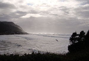
118:
106:
96:
82:
70:
62:
53:
43:
38:
21:
639:This article related to a river in Oregon is a
406:"NOAA Biological Assessment Invasive Plant EIS"
266:, in steep, thick forest, a half mile north of
664:
618:
557:
8:
705:Oregon placenames of Native American origin
671:
657:
625:
611:
564:
550:
369:
294:
715:Lincoln County, Oregon geography stubs
18:
7:
636:
634:
575:
573:
514:
512:
185:19 cu ft/s (0.54 m/s)
710:Lane County, Oregon geography stubs
243:) is a short river on the central
14:
457:. United States Geological Survey
700:Rivers of Lincoln County, Oregon
577:
516:
336:
321:
309:
297:
205:
142:44 sq mi (110 km)
27:
455:"United States Topographic Map"
1:
695:Rivers of Lane County, Oregon
54:Physical characteristics
643:. You can help Knowledge by
597:. You can help Knowledge by
593:state location article is a
536:. You can help Knowledge by
532:state location article is a
120: • elevation
84: • elevation
257:at the foot of the mountain
108: • location
72: • location
736:
633:
572:
511:
160: • average
88:1,200 ft (370 m)
77:Central Oregon Coast Range
33:Mouth of the Yachats River
16:River in the United States
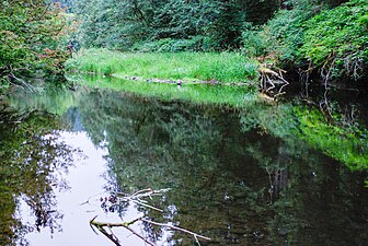
316:Yachats River, July 2010.
304:Yachats River, July 2010.
193:
146:
92:
58:
26:
465:– via ACME Mapper.
343:North fork Yachats River
134:15 mi (24 km)
492:44.30836°N 124.10772°W
415:. pp. Figure 11.3
331:on Yachats River Road.
358:List of Oregon rivers
497:44.30836; -124.10772
488: /
251:. The name is the
720:Oregon river stubs
268:Klickitat Mountain
652:
651:
606:
605:
545:
544:
387:. 2006. p. 1
197:
196:
727:
690:Rivers of Oregon
673:
666:
659:
635:
627:
620:
613:
581:
574:
566:
559:
552:
520:
513:
503:
502:
500:
499:
498:
493:
489:
486:
485:
484:
481:
468:
466:
464:
462:
451:
445:
444:
442:
441:
430:
424:
423:
421:
420:
414:
402:
396:
395:
393:
392:
382:
374:
340:
325:
313:
301:
239:
234:
233:
230:
229:
226:
223:
220:
217:
214:
211:
161:
85:
73:
31:
19:
735:
734:
730:
729:
728:
726:
725:
724:
680:
679:
678:
677:
632:
631:
571:
570:
509:
506:
496:
494:
490:
487:
482:
479:
477:
475:
474:
472:
471:
460:
458:
453:
452:
448:
439:
437:
432:
431:
427:
418:
416:
408:
404:
403:
399:
390:
388:
380:
376:
375:
371:
366:
354:
349:
348:
347:
344:
341:
332:
326:
317:
314:
305:
302:
290:
264:Yachats, Oregon
237:
208:
204:
189:
159:
121:
109:
83:
71:
34:
17:
12:
11:
5:
733:
731:
723:
722:
717:
712:
707:
702:
697:
692:
682:
681:
676:
675:
668:
661:
653:
650:
649:
630:
629:
622:
615:
607:
604:
603:
587:Lincoln County
582:
569:
568:
561:
554:
546:
543:
542:
521:
470:
469:
446:
425:
397:
385:Forest Service
368:
367:
365:
362:
361:
360:
353:
350:
346:
345:
342:
335:
333:
327:
320:
318:
315:
308:
306:
303:
296:
293:
292:
291:
289:
286:
195:
194:
191:
190:
188:
187:
186:
181:
180:
179:
164:
162:
156:
155:
152:
148:
147:
144:
143:
140:
136:
135:
132:
128:
127:
122:
119:
116:
115:
110:
107:
104:
103:
100:
94:
93:
90:
89:
86:
80:
79:
74:
68:
67:
64:
60:
59:
56:
55:
51:
50:
45:
41:
40:
36:
35:
32:
24:
23:
15:
13:
10:
9:
6:
4:
3:
2:
732:
721:
718:
716:
713:
711:
708:
706:
703:
701:
698:
696:
693:
691:
688:
687:
685:
674:
669:
667:
662:
660:
655:
654:
648:
646:
642:
637:
628:
623:
621:
616:
614:
609:
608:
602:
600:
596:
592:
588:
583:
580:
576:
567:
562:
560:
555:
553:
548:
547:
541:
539:
535:
531:
527:
522:
519:
515:
510:
507:
504:
501:
456:
450:
447:
435:
429:
426:
412:
411:word document
407:
401:
398:
386:
379:
373:
370:
363:
359:
356:
355:
351:
339:
334:
330:
324:
319:
312:
307:
300:
295:
287:
285:
281:
279:
274:
269:
265:
260:
258:
255:name meaning
254:
250:
246:
242:
241:
232:
202:
201:Yachats River
192:
184:
182:
177:
173:
169:
168:
166:
165:
163:
157:
153:
149:
145:
141:
137:
133:
129:
126:
123:
117:
114:
113:Pacific Ocean
111:
105:
101:
99:
95:
91:
87:
81:
78:
75:
69:
65:
61:
57:
52:
49:
48:United States
46:
42:
37:
30:
25:
22:Yachats River
20:
645:expanding it
638:
599:expanding it
584:
538:expanding it
523:
508:
505:
473:
459:. Retrieved
449:
438:. Retrieved
436:. 2004-02-24
428:
417:. Retrieved
400:
389:. Retrieved
372:
329:Sitka spruce
282:
261:
256:
200:
198:
172:cu ft/s
526:Lane County
495: /
483:124°06′28″W
461:January 16,
183:September:
167:December:
684:Categories
480:44°18′30″N
440:2006-08-20
419:2007-07-31
391:2006-08-20
364:References
273:river mile
174:(9.9
139:Basin size
278:river bar
170:350
151:Discharge
125:sea level
352:See also
39:Location
383:. USDA
288:Gallery
44:Country
591:Oregon
530:Oregon
253:native
249:Eugene
245:Oregon
240:-hahts
154:
131:Length
102:
66:
63:Source
585:This
524:This
381:(PDF)
98:Mouth
641:stub
595:stub
534:stub
463:2016
199:The
238:YAH
176:m/s
686::
589:,
528:,
259:.
222:ɑː
216:ɑː
672:e
665:t
658:v
647:.
626:e
619:t
612:v
601:.
565:e
558:t
551:v
540:.
443:.
422:.
413:)
409:(
394:.
231:/
228:s
225:t
219:h
213:j
210:ˈ
207:/
203:(
178:)
Text is available under the Creative Commons Attribution-ShareAlike License. Additional terms may apply.