19:
108:
and other urban areas occupying less than 5% of the area, about 85% is farmed and the remainder predominantly pastoral. The area is drained by several rivers including:
319:
176:
170:
495:
78:
558:
182:
548:
520:
140:
90:
74:
139:
The area includes
Neolithic hill forts, remains of Roman villas and many listed buildings. The area also includes 9477 ha of the
515:
430:
375:
349:
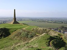
553:
470:
94:
334:
162:
156:
129:
305:
221:
74 Scheduled
Monuments. Some of the oldest are Neolithic, Bronze Age or Iron Age including hill forts, such as
46:
222:
109:
226:
54:
234:
202:
82:
462:
456:
491:
466:
511:
426:
371:
285:
281:
262:
258:
242:
225:
and Bowl barrows. The Romano-British period is represented with several sites including the
212:
277:
266:
238:
167:
133:
58:
50:
253:
order, from the 11th. More recent sites include several motte-and-bailey castles such as
186:
18:
542:
125:
98:
86:
62:
400:
270:
254:
250:
66:
265:
also appear in the list. The most recent monuments include the Round House, a
121:
117:
113:
339:
at www..naturalengland.org.uk Upload from 24 April 2014 accessed 2 Nov 2014.
195:
208:
198:
35:
246:
31:
230:
105:
70:
39:
57:. It covers 78,579 hectares (303.40 sq mi) and runs from
17:
257:, and church crosses which date from the Middle Ages. Several
73:
lies roughly in the centre of the area. To the west are the
324:
at www.naturalengland.org.uk. Accessed on 6 Apr 2013.
310:
at www.naturalengland.org.uk. Accessed on 6 Apr 2013.
241:, which was founded in the 7th or 8th century, and
307:NCA 140: Yeovil Scarplands - Key Facts & Data
185:(SSSI) wholly or partly within the NCA including
8:
336:NCA Profile:140 Yeovil Scarplands (NE557)
298:
321:Yeovil Scarplands - Character Area 140
104:With a predominantly rural landscape,
435:Research records (formerly PastScape)
380:Research records (formerly PastScape)
237:. Religious sites are represented by
147:Designated Areas and Listed Buildings
53:, the UK Government's advisor on the
7:
405:Somerset Historic Environment Record
183:Sites of Special Scientific Interest
79:Vale of Taunton and Quantock Fringes
521:National Heritage List for England
141:Area of Outstanding Natural Beauty
91:Blackmoor Vale and Vale of Wardour
14:
490:. Sutton Publishing. p. 32.
151:The NCA includes some or all of:
30:are a natural region in southern
276:4317 Listed Buildings including
215:with over 70% being Broadleaved.
218:13 Registered Parks and Gardens
95:Marshwood and Powerstock Vales
69:in the northeast. The town of
1:
233:floor, now on display in the
229:which included an extensive
516:"The Round House (1056279)"
376:"Muchelney Abbey (193791)"
350:"Museum of Somerset opens!"
575:
559:Natural regions of England
461:. Dovecote Press. p.
431:"Monument No. 200127"
549:Natural regions of Dorset
407:. Somerset County Council
352:. Victoria County History
191:31 Local Geological Sites
486:Warren, Derrick (2005).
161:West Dorset Alder Woods
45:The region is listed as
81:, to the north are the
47:National Character Area
93:and to the south, the
89:, to the east are the
23:
554:Geography of Somerset
455:Byford, Enid (1987).
21:
458:Somerset Curiosities
211:of which 1251 ha is
61:in the southwest to
227:Low Ham Roman Villa
55:natural environment
34:in the counties of
401:"Montacute Priory"
235:Museum of Somerset
155:Bracket’s Coppice
83:Mid Somerset Hills
24:
497:978-0-7509-4057-3
273:dating from 1779.
259:packhorse bridges
223:Kenwalch's Castle
175:Horn Park Quarry
28:Yeovil Scarplands
566:
533:
532:
530:
528:
512:Historic England
508:
502:
501:
488:Curious Somerset
483:
477:
476:
452:
446:
445:
443:
441:
427:Historic England
423:
417:
416:
414:
412:
397:
391:
390:
388:
386:
372:Historic England
368:
362:
361:
359:
357:
346:
340:
331:
325:
317:
311:
303:
286:Tintinhull Court
282:Barrington Court
263:Bow Bridge, Plox
243:Montacute Priory
213:ancient woodland
574:
573:
569:
568:
567:
565:
564:
563:
539:
538:
537:
536:
526:
524:
510:
509:
505:
498:
485:
484:
480:
473:
454:
453:
449:
439:
437:
425:
424:
420:
410:
408:
399:
398:
394:
384:
382:
370:
369:
365:
355:
353:
348:
347:
343:
332:
328:
318:
314:
304:
300:
295:
278:Montacute House
267:village lock-up
239:Muchelney Abbey
201:including 2 at
168:Hardington Moor
149:
134:Whitelake River
51:Natural England
12:
11:
5:
572:
570:
562:
561:
556:
551:
541:
540:
535:
534:
503:
496:
478:
471:
447:
418:
392:
363:
341:
326:
312:
297:
296:
294:
291:
290:
289:
274:
249:priory of the
219:
216:
205:
192:
189:
187:Rampisham Down
181:A total of 30
179:
173:
165:
159:
148:
145:
13:
10:
9:
6:
4:
3:
2:
571:
560:
557:
555:
552:
550:
547:
546:
544:
523:
522:
517:
513:
507:
504:
499:
493:
489:
482:
479:
474:
468:
464:
460:
459:
451:
448:
436:
432:
428:
422:
419:
406:
402:
396:
393:
381:
377:
373:
367:
364:
351:
345:
342:
338:
337:
330:
327:
323:
322:
316:
313:
309:
308:
302:
299:
292:
287:
283:
279:
275:
272:
268:
264:
260:
256:
252:
248:
244:
240:
236:
232:
228:
224:
220:
217:
214:
210:
206:
204:
200:
197:
193:
190:
188:
184:
180:
178:
174:
172:
169:
166:
164:
160:
158:
154:
153:
152:
146:
144:
142:
137:
135:
131:
127:
126:River Parrett
123:
119:
115:
111:
107:
102:
100:
96:
92:
88:
84:
80:
76:
72:
68:
64:
60:
56:
52:
48:
43:
41:
37:
33:
29:
20:
16:
525:. Retrieved
519:
506:
487:
481:
457:
450:
438:. Retrieved
434:
421:
409:. Retrieved
404:
395:
385:15 September
383:. Retrieved
379:
366:
354:. Retrieved
344:
335:
329:
320:
315:
306:
301:
150:
138:
103:
99:Dorset Downs
63:Chesterblade
44:
27:
25:
15:
356:9 September
271:Castle Cary
255:Cary Castle
251:Benedictine
207:4386 ha of
67:Upton Noble
22:Hamdon Hill
543:Categories
472:0946159483
293:References
261:, such as
122:River Isle
118:River Cary
114:River Brue
75:Blackdowns
196:Limestone
194:7 Active
130:River Yeo
110:River Axe
527:21 March
333:Updated
209:woodland
203:Ham Hill
199:Quarries
132:and the
85:and the
77:and the
36:Somerset
440:17 July
411:12 July
247:Cluniac
87:Mendips
49:140 by
32:England
494:
469:
284:&
231:mosaic
106:Yeovil
71:Yeovil
40:Dorset
59:Chard
529:2014
492:ISBN
467:ISBN
442:2011
413:2009
387:2014
358:2014
245:, a
97:and
65:and
38:and
26:The
269:in
177:NNR
171:NNR
163:SAC
157:SAC
545::
518:.
514:.
465:.
463:16
433:.
429:.
403:.
378:.
374:.
280:,
143:.
136:.
128:,
124:,
120:,
116:,
112:,
101:.
42:.
531:.
500:.
475:.
444:.
415:.
389:.
360:.
288:.
Text is available under the Creative Commons Attribution-ShareAlike License. Additional terms may apply.