63:
379:
369:
40:
481:
70:
336:
Peninsula. Ymer Island's northern half forms a peninsula named Gunnar
Anderson Land having its narrow isthmus in the west. The fjord between the two halves of the island is named
501:
168:
62:
122:
292:
304:, which published many accounts of Swedish expeditions to Spitsbergen and Greenland. The journal had been named after the giant
399:
230:
347:, its highest peak, reaches a height of 1900 m. Celsius Bjerg is located at the southeastern end of the island.
329:
235:
325:
173:
162:
485:
358:
344:
207:
378:
351:
313:
276:
26:
299:
506:
495:
357:
is located on the other side of Kaiser Franz Joseph Fjord, off the southern shore of
110:
368:
337:
39:
418:
333:
137:
124:
288:
221:
309:
480:
382:
284:
377:
367:
441:
452:
305:
95:
464:
Prostar
Sailing Directions 2005 Greenland and Iceland Enroute
343:
Ymer Island has an area of 2,437 km. It is mountainous;
298:
Ymer Island is named after the
Swedish geographical journal
324:
The island lies on the southern side of the entrance of
44:
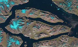
View of Ymer Island with ice floes in the foreground.
430:
Catalogue of place names in northern East
Greenland
262:
254:
246:
241:
229:
213:
203:
195:
187:
179:
161:
153:
116:
106:
101:
90:
24:
8:
432:, Geological Survey of Denmark and Greenland
19:
18:
411:
94:Named after the mythical Norse giant
7:
361:, the NW extremity of Ymer Island.
82:Location of Ymer Island in Greenland
157:2,437 km (941 sq mi)
69:
14:
293:Northeast Greenland National Park
502:Uninhabited islands of Greenland
479:
68:
61:
38:
419:Angelin Bjerg - Peakbagger.com
1:
400:List of islands of Greenland
372:Mountaintops in Ymer Island
199:1,900 m (6200 ft)
523:
365:
291:. The island is a part of
236:NE Greenland National Park
326:Kaiser Franz Joseph Fjord
218:
191:36 km (22.4 mi)
183:91 km (56.5 mi)
56:
49:
37:
453:Celsius Bjerg - Mapcarta
308:, the forefather of the
332:separating it from the
386:
373:
280:
196:Highest elevation
381:
371:
488:at Wikimedia Commons
169:largest in Greenland
258:0/km (0/sq mi)
231:Unincorporated area
134: /
21:
16:Island in Greenland
387:
374:
204:Highest point
51:Map of Ymer Island
484:Media related to
391:
390:
270:
269:
138:73.150°N 24.333°W
514:
483:
467:
461:
455:
450:
444:
439:
433:
427:
421:
416:
364:
363:
355:(Teufelsschloss)
350:The conspicuous
287:in northeastern
174:largest in world
149:
148:
146:
145:
144:
139:
135:
132:
131:
130:
127:
72:
71:
65:
42:
22:
522:
521:
517:
516:
515:
513:
512:
511:
492:
491:
476:
471:
470:
462:
458:
451:
447:
440:
436:
428:
424:
417:
413:
408:
396:
385:satellite image
330:Antarctic Sound
322:
314:Norse mythology
225:
171:
143:73.150; -24.333
142:
140:
136:
133:
128:
125:
123:
121:
120:
86:
85:
84:
83:
80:
79:
78:
77:
73:
52:
45:
33:
32:
17:
12:
11:
5:
520:
518:
510:
509:
504:
494:
493:
490:
489:
475:
474:External links
472:
469:
468:
456:
445:
434:
422:
410:
409:
407:
404:
403:
402:
395:
392:
389:
388:
375:
359:Cape Petersens
352:Devil's Castle
321:
318:
268:
267:
264:
260:
259:
256:
252:
251:
248:
244:
243:
239:
238:
233:
227:
226:
219:
216:
215:
214:Administration
211:
210:
205:
201:
200:
197:
193:
192:
189:
185:
184:
181:
177:
176:
165:
159:
158:
155:
151:
150:
118:
114:
113:
108:
104:
103:
99:
98:
92:
88:
87:
81:
75:
74:
67:
66:
60:
59:
58:
57:
54:
53:
50:
47:
46:
43:
35:
34:
30:
25:
15:
13:
10:
9:
6:
4:
3:
2:
519:
508:
505:
503:
500:
499:
497:
487:
482:
478:
477:
473:
465:
460:
457:
454:
449:
446:
443:
438:
435:
431:
426:
423:
420:
415:
412:
405:
401:
398:
397:
393:
384:
380:
376:
370:
366:
362:
360:
356:
353:
348:
346:
345:Angelin Bjerg
341:
339:
335:
331:
327:
319:
317:
315:
311:
307:
303:
302:
296:
294:
290:
286:
282:
278:
274:
265:
263:Ethnic groups
261:
257:
253:
249:
245:
240:
237:
234:
232:
228:
224:
223:
217:
212:
209:
208:Angelin Bjerg
206:
202:
198:
194:
190:
186:
182:
178:
175:
170:
166:
164:
160:
156:
152:
147:
119:
115:
112:
111:Greenland Sea
109:
105:
100:
97:
93:
89:
64:
55:
48:
41:
36:
28:
23:
463:
459:
448:
437:
429:
425:
414:
354:
349:
342:
323:
300:
297:
272:
271:
255:Pop. density
242:Demographics
220:
486:Ymer Island
338:Dusen Fjord
328:, with the
273:Ymer Island
141: /
117:Coordinates
76:Ymer Island
27:Native name
20:Ymer Island
496:Categories
406:References
334:Suess Land
247:Population
320:Geography
289:Greenland
222:Greenland
163:Area rank
102:Geography
91:Etymology
466:, p. 120
394:See also
283:) is an
250:0 (2021)
107:Location
383:Landsat
129:24°20′W
126:73°09′N
310:Jotuns
285:island
281:Ymer Ø
277:Danish
180:Length
172:184th
31:Ymer Ø
188:Width
507:Ymir
442:UNEP
306:Ymir
301:Ymer
266:none
167:5th
154:Area
96:Ymir
312:in
498::
340:.
316:.
295:.
279::
29::
275:(
Text is available under the Creative Commons Attribution-ShareAlike License. Additional terms may apply.