74:
406:
43:
55:
81:
317:. It changed its name to Yokoshiba on December 28, 1892. Musha District became part of Sanbu District from April 1, 1897. On May 10, 1897, Yokoshiba was elevated to town status. It expanded through the annexation of the neighboring villages of Ōfusa and Kamisakae on July 1, 1955.
462:
73:
443:
105:
42:
54:
472:
436:
360:
332:, and thus no longer exists as an independent municipality. Sōsa District was dissolved as a result of this merger.
467:
145:
429:
325:
314:
329:
295:
187:
299:
174:
157:
238:
340:
169:
405:
335:
As of
November 1, 2005, (the last census data prior to the merger) the town had an estimated
303:
162:
60:
150:
413:
456:
321:
262:
336:
234:
120:
107:
388:
229:
307:
343:
of 434 persons per km. The total area was 33.60 km.
417:
313:
Asahi
Village was established on April 1, 1889, within
363:[Record of Municipal Mergers Since Showa 60].
320:
On March 27, 2006, Yokoshiba, along with the town of
258:
228:
220:
212:
207:
199:
194:
180:
168:
156:
144:
136:
21:
47:Yokoshiba (foreground) and Miyagawa (background)
361:"総務省|令和2年版 地方財政白書|資料編 〔附属資料〕 昭和60年度以降の市町村合併の実績"
285:
279:
437:
8:
463:Dissolved municipalities of Chiba Prefecture
412:This Chiba Prefecture location article is a
444:
430:
18:
352:
253:
227:
206:
193:
135:
100:
66:
51:
39:
257:
219:
211:
203:33.60 km (12.97 sq mi)
198:
179:
167:
155:
143:
7:
402:
400:
328:), was merged to create the town of
16:Former municipality in Kantō, Japan
14:
80:
404:
389:Yokoshibahikari official website
79:
72:
53:
41:
1:
416:. You can help Knowledge by
286:
489:
399:
280:
268:
254:
249:
245:
224:434/km (1,120/sq mi)
101:
67:
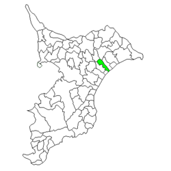
59:Location of Yokoshiba in
52:
40:
33:
25:
473:Chiba geography stubs
221: • Density
117: /
35:Former municipality
341:population density
213: • Total
200: • Total
121:35.650°N 140.483°E
425:
424:
272:
271:
93:Location in Japan
480:
446:
439:
432:
408:
401:
393:
376:
375:
373:
372:
357:
339:of 14,589 and a
304:Chiba Prefecture
293:
292:
289:
283:
282:
163:Chiba Prefecture
132:
131:
129:
128:
127:
122:
118:
115:
114:
113:
110:
83:
82:
76:
61:Chiba Prefecture
57:
45:
28:
19:
488:
487:
483:
482:
481:
479:
478:
477:
468:Yokoshibahikari
453:
452:
451:
450:
397:
391:
385:
380:
379:
370:
368:
359:
358:
354:
349:
330:Yokoshibahikari
290:
287:Yokoshiba-machi
277:
188:Yokoshibahikari
185:
126:35.650; 140.483
125:
123:
119:
116:
111:
108:
106:
104:
103:
97:
96:
95:
94:
91:
90:
89:
88:
84:
63:
48:
36:
29:
26:
24:
17:
12:
11:
5:
486:
484:
476:
475:
470:
465:
455:
454:
449:
448:
441:
434:
426:
423:
422:
409:
395:
394:
384:
383:External links
381:
378:
377:
351:
350:
348:
345:
315:Musha District
300:Sanbu District
270:
269:
266:
265:
260:
256:
255:
252:
251:
247:
246:
243:
242:
232:
226:
225:
222:
218:
217:
214:
210:
209:
205:
204:
201:
197:
196:
192:
191:
184:March 27, 2006
182:
178:
177:
172:
166:
165:
160:
154:
153:
148:
142:
141:
138:
134:
133:
99:
98:
92:
86:
85:
78:
77:
71:
70:
69:
68:
65:
64:
58:
50:
49:
46:
38:
37:
34:
31:
30:
22:
15:
13:
10:
9:
6:
4:
3:
2:
485:
474:
471:
469:
466:
464:
461:
460:
458:
447:
442:
440:
435:
433:
428:
427:
421:
419:
415:
410:
407:
403:
398:
392:(in Japanese)
390:
387:
386:
382:
367:(in Japanese)
366:
362:
356:
353:
346:
344:
342:
338:
333:
331:
327:
326:Sōsa District
323:
318:
316:
311:
309:
305:
301:
297:
288:
276:
267:
264:
261:
248:
244:
240:
236:
233:
231:
223:
215:
202:
189:
186:(now part of
183:
176:
173:
171:
164:
161:
159:
152:
149:
147:
139:
130:
102:Coordinates:
75:
62:
56:
44:
32:
20:
418:expanding it
411:
396:
369:. Retrieved
364:
355:
334:
319:
312:
274:
273:
298:located in
263:Prunus mume
124: /
457:Categories
371:2024-02-28
347:References
337:population
208:Population
158:Prefecture
275:Yokoshiba
235:UTC+09:00
230:Time zone
87:Yokoshiba
23:Yokoshiba
170:District
112:140°29′E
250:Symbols
137:Country
109:35°39′N
324:(from
322:Hikari
294:was a
216:14,589
181:Merged
146:Region
308:Japan
175:Sanbu
151:Kantō
140:Japan
414:stub
296:town
259:Tree
195:Area
365:総務省
281:横芝町
239:JST
27:横芝町
459::
310:.
306:,
302:,
284:,
445:e
438:t
431:v
420:.
374:.
291:)
278:(
241:)
237:(
190:)
Text is available under the Creative Commons Attribution-ShareAlike License. Additional terms may apply.