266:
gun emplacements, and buildings are accessible when one is on the island. Hobbyists with metal detectors are strongly cautioned against using them on the island due to the possibility of live ordnance left over from training purposes during the war. Safely accessing the island is a difficult and sometimes dangerous journey due to dangerous tides and winds. The safest access is in
Courtenay Bay due to its protection from extreme flood and tidal action compared to the conditions found on the beach side near to the dock built during the
258:
242:
brought in to fill the 50000 gallon cement water tank via the nearest creek on
Hardwicke Island. Filling this tank and its challenges led to the only death on Yorke, Gnr Brunt, when the skiff he and others were on was swamped returning from a maintenance trip to Hardwicke Island. Brunt's leg tangled in the boat tow line and he was lost when it sank. Efforts to recover him were not successful.
234:
275:
be found out in plain site on the island. Recent visits have shown the use of ground penetrating radar (Suzie Guns) and damage to walls and floors in the main bunker trying to find these rooms as reported in an inaccurate Urban
Exploration posting. Research shows the entire fort built on bedrock, with final construction involving over 100,000 cubic feet of concrete.
190:
27:
245:
Yorke Island was an isolated post which combined with lack of action, the advent of the conscript act, and minimal contact with locals led to some discipline issues, nicknamed "Going Yorkie". Segregation was also a difficulty: some men served on the island at the same time did not meet until reunions
274:
was dismantled, meaning
Courtenay Bay offers safest access to those requiring anchorage. There are no operators with permits to conduct tours of Yorke Island on shore at this time. Visitors should also be aware that there are no hidden rooms, bunkers, ordnance rooms, or anything other than what can
265:
Although the fort is abandoned, Yorke Island itself is now a
Conservancy protected under BC Parks. Recent efforts by volunteers and local groups have now allowed for a major cleanup at the fort. Trails have been cut and marked to areas of safe access and interest. Extensive remnants of the bunkers,
241:
Approximately 60 buildings were built to support the garrison. A major challenge with Yorke Island was a lack of drinking water. Water was at first supplied by Union Steam ships while dropping off construction materials. After this was determined to be too inefficient, a scow with a large tank was
201:
and determined suitable locations for coastal defences. Yorke Island was determined to be a suitable site. The site was equipped with two 4.7" Quick firing guns, later replaced by two 6" Mk7 guns on Mk 2 mounting (transferred from the
284:
270:. Explorers of the Island are strongly cautioned against random landings on the shore of the Island due to the prevalence of still effective barbed wire over most of the perimeter. The dock built during the
363:
413:
368:
181:, Yorke Island was strategically placed to protect the entrances of what was considered the backdoor access to Vancouver during World War II.
473:
424:
468:
463:
364:
https://www.theglobeandmail.com/news/national/british-columbia/old-bc-fort-was-braced-for-japanese-invasion-that-never-came/article2230032/
414:
https://books.google.com/books?id=Vp_MygAACAAJ&q=Yorke+Island+and+the+Uncertain+War,+Defending+Canada's+western+coast+during+WWII+
345:
75:
215:
49:
177:
have to pass. As
Hardwicke Island separates two channels offering passages between Vancouver Island and the mainland coast of
408:
369:
https://www.theglobeandmail.com/news/national/british-columbia/photos-yorke-island-then-and-now/article2230058/
57:
53:
37:
249:
As the threat of attack diminished the garrison was decommissioned and the fort was abandoned by early 1946.
373:
207:
337:
223:
341:
332:
Vancouver
Defended. A History of the Men and Arms of the Lower Mainland Defences, 1859 - 1949.
271:
267:
178:
174:
170:
162:
158:
102:
98:
330:
227:
166:
457:
230:
and their crew, were on station to assist the fort in examining all passing traffic.
211:
409:
https://web.archive.org/web/20120618135327/http://kasha.ezabu.com:80/2012/05/12/434/
304:
219:
203:
237:
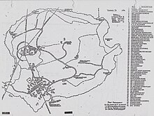
World War II era map of Yorke Island, showing
Canadian military's infrastructure
383:
233:
197:
In 1938 Major Treatt of the Canada War
Department, inspected the west coast of
403:
398:
393:
388:
378:
439:
426:
173:
and
Sunderland Channel which all vessels traveling between the mainland and
257:
193:
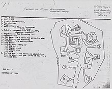
1945 schematic of Canadian military's fixed defence works on Yorke Island
374:
http://www.bcdailybuzz.com/media/3998/In_the_camouflage_of_Yorke_Island/
189:
417:&hl=en&sa=X&ei=fXO0T8X1N8nKiQKgwdWfAg&ved=0CDIQ6AEwAA
285:
List of World War II-era fortifications on the British Columbia Coast
198:
56:
external links, and converting useful links where appropriate into
256:
232:
222:
were positioned to maintain a night fighting ability. In addition
188:
218:
guns at two different sites. In all three 800 million carbon arc
20:
101:
and Sunderland Channel between Vancouver Island and mainland
45:
144:
136:
131:
123:
118:
110:
90:
329:
226:, nicknamed the "Gumboot Navy" due to the use of
157:is a small islet located off of the north end of
40:may not follow Knowledge's policies or guidelines
8:
384:https://www.youtube.com/watch?v=i6H5WIegM1g0
169:, it occupies a choke point at the split of
404:https://www.youtube.com/watch?v=PuejZyJkmOc
399:https://www.youtube.com/watch?v=x7cazEWKq9M
394:https://www.youtube.com/watch?v=nUO80cRI9js
389:https://www.youtube.com/watch?v=rr-WcgqPJhY
379:https://www.youtube.com/watch?v=za8DwuaGjo4
87:
76:Learn how and when to remove this message
296:
7:
246:were arranged well after the war.
16:Island in British Columbia, Canada
14:
25:
1:
474:World War II sites in Canada
214:defence was provided by two
206:Battery). Also fitted was a
469:Islands of British Columbia
464:History of British Columbia
490:
95:
91:Yorke Island coastal fort
328:Moogk, Peter N. (1978),
305:"BC Geographical Names"
440:50.44639°N 125.97722°W
262:
238:
194:
260:
236:
192:
445:50.44639; -125.97722
161:in the south end of
46:improve this article
436: /
338:Antonson Publishing
224:examination vessels
210:"examination gun".
58:footnote references
263:
239:
195:
165:. Located in the
124:Controlled by
152:
151:
86:
85:
78:
481:
451:
450:
448:
447:
446:
441:
437:
434:
433:
432:
429:
351:
350:
335:
325:
319:
318:
316:
315:
301:
272:Second World War
268:Second World War
179:British Columbia
175:Vancouver Island
171:Johnstone Strait
163:Johnstone Strait
159:Hardwicke Island
119:Site information
106:
103:British Columbia
99:Johnstone Strait
97:at the split of
88:
81:
74:
70:
67:
61:
29:
28:
21:
489:
488:
484:
483:
482:
480:
479:
478:
454:
453:
444:
442:
438:
435:
430:
427:
425:
423:
422:
360:
355:
354:
348:
327:
326:
322:
313:
311:
303:
302:
298:
293:
281:
255:
228:fishing vessels
208:6 pdr Hotchkiss
187:
96:
82:
71:
65:
62:
43:
34:This article's
30:
26:
17:
12:
11:
5:
487:
485:
477:
476:
471:
466:
456:
455:
420:
419:
411:
406:
401:
396:
391:
386:
381:
376:
371:
366:
359:
358:External links
356:
353:
352:
346:
320:
309:apps.gov.bc.ca
295:
294:
292:
289:
288:
287:
280:
277:
254:
251:
186:
183:
167:Inside Passage
150:
149:
146:
142:
141:
138:
134:
133:
129:
128:
125:
121:
120:
116:
115:
112:
108:
107:
93:
92:
84:
83:
38:external links
33:
31:
24:
15:
13:
10:
9:
6:
4:
3:
2:
486:
475:
472:
470:
467:
465:
462:
461:
459:
452:
449:
418:
415:
412:
410:
407:
405:
402:
400:
397:
395:
392:
390:
387:
385:
382:
380:
377:
375:
372:
370:
367:
365:
362:
361:
357:
349:
347:0-919900-26-7
343:
339:
336:, Vancouver:
334:
333:
324:
321:
310:
306:
300:
297:
290:
286:
283:
282:
278:
276:
273:
269:
259:
252:
250:
247:
243:
235:
231:
229:
225:
221:
217:
213:
212:Anti-aircraft
209:
205:
200:
191:
184:
182:
180:
176:
172:
168:
164:
160:
156:
147:
143:
139:
135:
130:
126:
122:
117:
113:
109:
104:
100:
94:
89:
80:
77:
69:
59:
55:
54:inappropriate
51:
47:
41:
39:
32:
23:
22:
19:
421:
416:
331:
323:
312:. Retrieved
308:
299:
264:
248:
244:
240:
220:searchlights
204:Stanley Park
196:
155:Yorke Island
154:
153:
132:Site history
114:coastal fort
72:
63:
48:by removing
35:
18:
443: /
431:125°58′38″W
261:Yorke Today
216:40mm Bofors
145:In use
458:Categories
428:50°26′47″N
314:2022-04-22
291:References
66:April 2022
50:excessive
279:See also
185:History
148:1938-46
44:Please
36:use of
344:
199:Canada
127:Canada
253:Today
137:Built
342:ISBN
140:1938
111:Type
52:or
460::
340:,
307:.
105:,
317:.
79:)
73:(
68:)
64:(
60:.
42:.
Text is available under the Creative Commons Attribution-ShareAlike License. Additional terms may apply.