182:
19:
223:
242:
252:
121:
Scale 1:250000 topographic map of
Antarctica. Scientific Committee on Antarctic Research (SCAR). Since 1993, regularly upgraded and updated.
247:
157:
134:
216:
67:
209:
115:
Scale 1:200000 topographic map. DOS 610 Series, Sheet W 66 66. Directorate of
Overseas Surveys, UK, 1976.
144:
112:
30:
193:
56:
The point is named after the historical settlement of
Zagrade in Southwestern Bulgaria.
189:
46:
38:
236:
96:
37:, ‘Nos Zagrade’ \'nos za-'gra-de\) is the point on the east side of the entrance to
181:
100:
42:
18:
50:
82:
69:
17:
131:
138:
22:
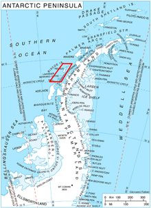
Location of Biscoe
Islands in the Antarctic Peninsula region.
118:
197:
166:
217:
8:
167:Antarctic Place-names Commission of Bulgaria
165:This article includes information from the
224:
210:
95:, which is 2.47 km east-northeast of
7:
178:
176:
147:SCAR Composite Antarctic Gazetteer.
196:. You can help Knowledge (XXG) by
14:
119:Antarctic Digital Database (ADD).
180:
135:Antarctic Place-names Commission
243:Headlands of the Biscoe Islands
253:Biscoe Islands geography stubs
169:which is used with permission.
132:Bulgarian Antarctic Gazetteer.
99:and 1.98 km northwest of
1:
113:British Antarctic Territory.
103:. British mapping in 1976.
64:Zagrade Point is located at
269:
248:Bulgaria and the Antarctic
175:
137:. (details in Bulgarian,
34:
160:Copernix satellite image
192:location article is a
41:on the north coast of
23:
83:66.24944°S 66.91528°W
21:
88:-66.24944; -66.91528
79: /
24:
205:
204:
260:
226:
219:
212:
184:
177:
94:
93:
91:
90:
89:
84:
80:
77:
76:
75:
72:
36:
268:
267:
263:
262:
261:
259:
258:
257:
233:
232:
231:
230:
173:
154:
128:
109:
87:
85:
81:
78:
73:
70:
68:
66:
65:
62:
12:
11:
5:
266:
264:
256:
255:
250:
245:
235:
234:
229:
228:
221:
214:
206:
203:
202:
190:Biscoe Islands
185:
162:
161:
158:Zagrade Point.
153:
152:External links
150:
149:
148:
145:Zagrade Point.
142:
127:
124:
123:
122:
116:
108:
105:
61:
58:
47:Biscoe Islands
39:Suregetes Cove
13:
10:
9:
6:
4:
3:
2:
265:
254:
251:
249:
246:
244:
241:
240:
238:
227:
222:
220:
215:
213:
208:
207:
201:
199:
195:
191:
186:
183:
179:
174:
171:
170:
168:
159:
156:
155:
151:
146:
143:
140:
136:
133:
130:
129:
125:
120:
117:
114:
111:
110:
106:
104:
102:
98:
97:Kuvikal Point
92:
59:
57:
54:
52:
48:
44:
40:
32:
28:
27:Zagrade Point
20:
16:
198:expanding it
187:
172:
164:
163:
101:Burton Point
63:
55:
43:Krogh Island
26:
25:
15:
141:in English)
86: /
35:нос Заграде
237:Categories
139:basic data
126:References
74:66°54′55″W
71:66°14′58″S
51:Antarctica
31:Bulgarian
60:Location
188:This
194:stub
107:Maps
45:in
239::
53:.
49:,
33::
225:e
218:t
211:v
200:.
29:(
Text is available under the Creative Commons Attribution-ShareAlike License. Additional terms may apply.