53:
719:
82:
699:
89:
38:
63:
353:
was first mentioned in 1662. Before 1918 the official name was
Felsozboró, or only Zboró. The total population in 1910 was 1,607 which included mostly Roman Catholic Slovaks. The region was devastated by the attacks of Tartars in the 13th century and the first settlers came here after 1400AD (Stara
782:
763:
548:
787:
113:
81:
52:
756:
541:
632:
286:
607:
387:
258:
652:
477:
749:
534:
505:
445:
417:
62:
276:
622:
729:
237:
718:
677:
577:
247:
597:
310:
37:
662:
558:
326:
166:
733:
726:
627:
330:
156:
354:
Bystrica). Zborov nad
Bystricou were founded by the Valach colonists in the 15th century.
637:
682:
388:
https://web.archive.org/web/20071116010355/http://www.statistics.sk/mosmis/eng/run.html
776:
672:
526:
363:
322:
642:
398:
647:
446:"Hustota obyvateľstva - obce [om7014rr_ukaz: Rozloha (Štvorcový meter)]"
667:
657:
375:
128:
115:
228:
592:
698:
617:
584:
570:
367:
334:
612:
602:
350:
346:
318:
254:
233:
392:
299:
512:(in Slovak). Statistical Office of the Slovak Republic. 2022-03-31
484:(in Slovak). Statistical Office of the Slovak Republic. 2015-04-17
452:(in Slovak). Statistical Office of the Slovak Republic. 2022-03-31
424:(in Slovak). Statistical Office of the Slovak Republic. 2022-03-31
371:
530:
737:
295:
285:
275:
265:
244:
227:
219:
214:
206:
198:
193:
185:
180:
172:
162:
152:
144:
21:
418:"Počet obyvateľov podľa pohlavia - obce (ročne)"
783:Villages and municipalities in Čadca District
757:
542:
8:
88:
472:
470:
468:
466:
764:
750:
549:
535:
527:
18:
409:
294:
284:
264:
226:
213:
205:
192:
179:
171:
143:
108:
74:
46:
34:
440:
438:
274:
243:
218:
197:
184:
161:
151:
7:
715:
713:
500:
498:
202:18.70 km (7.22 sq mi)
736:. You can help Knowledge (XXG) by
14:
717:
697:
87:
80:
61:
51:
36:
1:
788:Žilina Region geography stubs
506:"Hustota obyvateľstva - obce"
374:of 18.709 km. It has a
370:of 420 metres and covers an
804:
712:
478:"Základná charakteristika"
210:419 m (1,375 ft)
694:
565:
109:
75:
47:
35:
28:
378:of about 2290 people.
314:
246: • Summer (
129:49.38278°N 18.88194°E
688:Zborov nad Bystricou
307:Zborov nad Bystricou
101:Location in Slovakia
95:Zborov nad Bystricou
42:Zborov nad Bystricou
23:Zborov nad Bystricou
125: /
16:Village in Slovakia
678:Vysoká nad Kysucou
578:Krásno nad Kysucou
557:Municipalities of
347:historical records
220: • Total
199: • Total
186: • Mayor
134:49.38278; 18.88194
745:
744:
707:
706:
510:www.statistics.sk
482:www.statistics.sk
450:www.statistics.sk
422:www.statistics.sk
304:
303:
795:
766:
759:
752:
721:
714:
702:
701:
598:Dlhá nad Kysucou
551:
544:
537:
528:
521:
520:
518:
517:
502:
493:
492:
490:
489:
474:
461:
460:
458:
457:
442:
433:
432:
430:
429:
414:
251:
140:
139:
137:
136:
135:
130:
126:
123:
122:
121:
118:
91:
90:
84:
65:
55:
40:
19:
803:
802:
798:
797:
796:
794:
793:
792:
773:
772:
771:
770:
710:
708:
703:
696:
692:
561:
555:
525:
524:
515:
513:
504:
503:
496:
487:
485:
476:
475:
464:
455:
453:
444:
443:
436:
427:
425:
416:
415:
411:
406:
393:Village website
384:
360:
343:
271:
245:
173:First mentioned
133:
131:
127:
124:
119:
116:
114:
112:
111:
105:
104:
103:
102:
99:
98:
97:
96:
92:
71:
70:
69:
68:
59:
58:
43:
31:
24:
17:
12:
11:
5:
801:
799:
791:
790:
785:
775:
774:
769:
768:
761:
754:
746:
743:
742:
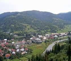
722:
705:
704:
695:
693:
691:
690:
685:
680:
675:
670:
665:
663:Stará Bystrica
660:
655:
650:
645:
640:
635:
630:
625:
620:
615:
610:
605:
600:
595:
589:
588:
581:
574:
566:
563:
562:
559:Čadca District
556:
554:
553:
546:
539:
531:
523:
522:
494:
462:
434:
408:
407:
405:
402:
401:
400:
396:
390:
383:
382:External links
380:
359:
356:
342:
339:
327:Čadca District
302:
301:
297:
293:
292:
289:
283:
282:
279:
273:
272:
269:
267:
263:
262:
252:
242:
241:
231:
225:
224:
221:
217:
216:
212:
211:
208:
204:
203:
200:
196:
195:
191:
190:
187:
183:
182:
178:
177:
174:
170:
169:
164:
160:
159:
154:
150:
149:
146:
142:
141:
107:
106:
100:
94:
93:
86:
85:
79:
78:
77:
76:
73:
72:
66:
60:
56:
50:
49:
48:
45:
44:
41:
33:
32:
29:
26:
25:
22:
15:
13:
10:
9:
6:
4:
3:
2:
800:
789:
786:
784:
781:
780:
778:
767:
762:
760:
755:
753:
748:
747:
741:
739:
735:
732:article is a
731:
728:
727:Žilina Region
723:
720:
716:
711:
700:
689:
686:
684:
681:
679:
676:
674:
671:
669:
666:
664:
661:
659:
656:
654:
651:
649:
646:
644:
641:
639:
636:
634:
631:
629:
628:Nová Bystrica
626:
624:
621:
619:
616:
614:
611:
609:
606:
604:
601:
599:
596:
594:
591:
590:
587:
586:
582:
580:
579:
575:
573:
572:
568:
567:
564:
560:
552:
547:
545:
540:
538:
533:
532:
529:
511:
507:
501:
499:
495:
483:
479:
473:
471:
469:
467:
463:
451:
447:
441:
439:
435:
423:
419:
413:
410:
403:
399:
397:
394:
391:
389:
386:
385:
381:
379:
377:
373:
369:
365:
357:
355:
352:
348:
340:
338:
336:
332:
331:Žilina Region
328:
324:
320:
316:
312:
308:
300:
298:
290:
288:
280:
278:
268:
260:
256:
253:
249:
239:
235:
232:
230:
222:
209:
201:
188:
175:
168:
165:
158:
155:
147:
138:
110:Coordinates:
83:
64:
54:
39:
27:
20:
738:expanding it
724:
709:
687:
583:
576:
569:
514:. Retrieved
509:
486:. Retrieved
481:
454:. Retrieved
449:
426:. Retrieved
421:
412:
364:municipality
361:
344:
333:of northern
323:municipality
306:
305:
281:+421 41
67:Coat of arms
395:(in Slovak)
366:lies at an
270:023 03
266:Postal code
189:Jozef Čička
132: /
777:Categories
673:Svrčinovec
516:2022-03-31
488:2022-03-31
456:2022-03-31
428:2022-03-31
404:References
376:population
315:Felsőzboró
215:Population
181:Government
120:18°52′55″E
117:49°22′58″N
730:geography
643:Podvysoká
638:Oščadnica
358:Geography
311:Hungarian
287:Car plate
277:Area code
229:Time zone
207:Elevation
683:Zákopčie
648:Radôstka
608:Klokočov
585:Turzovka
368:altitude
335:Slovakia
163:District
148:Slovakia
668:Staškov
658:Skalité
613:Klubina
603:Dunajov
351:village
341:History
329:in the
319:village
317:) is a
296:Website
145:Country
30:Village
653:Raková
633:Olešná
593:Čierne
157:Žilina
153:Region
725:This
623:Makov
618:Korňa
571:Čadca
255:UTC+2
234:UTC+1
223:2,191
167:Čadca
734:stub
372:area
362:The
349:the
321:and
259:CEST
194:Area
176:1662
57:Flag
345:In
325:in
248:DST
238:CET
779::
508:.
497:^
480:.
465:^
448:.
437:^
420:.
337:.
313::
291:CA
765:e
758:t
751:v
740:.
550:e
543:t
536:v
519:.
491:.
459:.
431:.
309:(
261:)
257:(
250:)
240:)
236:(
Text is available under the Creative Commons Attribution-ShareAlike License. Additional terms may apply.