334:
310:
322:
346:
36:
209:
that are under 300 m. The distance between the two hill ridges is 2 to 3 kilometres. In between, the valley stretches from west to east, sheltered from north winds. Flowing through the valley in this direction is the
565:
333:
588:
88:
569:
476:
517:
321:
205:
The
Zellertal is a trough-shaped valley with relatively gently sides and is bounded in the north and south by two chains of low
374:
begins at the eastern end of the valley. The
Zellertal wine region covers a larger area that the valley itself, has 15
435:
309:
266:
81:
345:
454:
593:
222:
150:
142:
387:
371:
265:
The symbol of the valley is the 15-metre-high
Zellertal Memorial which can be seen from a long way off. The
242:
168:
124:
570:
Map service of the
Landscape Information System of the Rhineland-Palatinate Nature Conservation Office (
477:
Map service of the
Landscape Information System of the Rhineland-Palatinate Nature Conservation Office (
450:
146:
431:
237:
as we travel upriver. To the west, on the
Palatine side, follow the next three parishes of Zellertal (
190:
411:
367:
172:
70:
292:
442:) in the east. On the western edge of Wachenheim, the B 47 has been extended to the west as a
300:
230:
176:
399:
250:
238:
138:
221:
The exit to the valley in the east lies at a height of about 135 m in
Rhenish Hesse in the
419:
288:
179:
538:
492:
386:
of 550 hectares. The wine region includes other wine-growing municipalities such as
277:
458:
423:
415:
383:
281:
582:
183:
273:
391:
234:
186:
395:
269:
246:
103:
90:
449:
On
Sundays and holidays from the beginning of May to the end of October the
443:
296:
194:
35:
20:
375:
254:
226:
285:
74:
19:
This article is about the region. For the collective municipality, see
284: 64 which runs along the hillside between Zell and Mölsheim. The
211:
164:
134:
439:
427:
379:
215:
303:. Other sights are described in the individual village articles.
206:
257:. The Zellertal ends here after 12 km at 185 m.
280:. It is located on an exposed viewing point near the
189:. The valley is named after the old municipality of
130:
120:
80:
66:
61:
53:
45:
28:
225:, to which belong the first 3 valley parishes of
16:Valley region in Rhineland-Palatinate, Germany
218:which is just under 43 kilometres long.
8:
25:
366:The Zellertal is the northern end of the
518:"Weinbetriebe im Alsenz- and Zellertal"
469:
402:, a left bank tributary of the Pfrimm.
305:
398:, which are in the side valley of the
572:Naturschutzverwaltung Rheinland-Pfalz
479:Naturschutzverwaltung Rheinland-Pfalz
7:
339:Pilgrimage church of Zell - interior
327:Pilgrimage church of Zell - exterior
418:–Marnheim), which runs between the
223:collective municipality of Monsheim
520:(in German). Donnersberg-Touristik
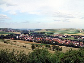
40:View of Albisheim in the Zellertal
14:
410:The Zellertal is accessed by the
344:
332:
320:
308:
272:monument was built in 1928 as a
34:
589:Valleys of Rhineland-Palatinate
276:in honour of the fallen of the
193:, which became part of the new
214:, a left ban tributary of the
175:. Its western part belongs to
1:
493:"Zellertaler Kriegerdenkmal"
610:
436:Neustadt an der Weinstraße
357:Economy and infrastructure
351:Vineyards in the Zellertal
295:, who was elevated to the
167:region in the east of the
18:
566:Location of the Zellertal
33:
291:of Zell is dedicated to
453:runs from Monsheim via
372:Rhenish Hesse wine area
171:in the German state of
430:) in the west and the
245:) and the parishes of
197:municipality in 1976.
182:, its eastern part to
169:North Palatine Uplands
125:North Palatine Uplands
543:Palatinatelexikon (Z)
497:Palatinatelexikon (Z)
451:Zeller Valley Railway
368:Palatine wine region
173:Rhineland-Palatinate
104:49.64556°N 8.12361°E
71:Rhineland-Palatinate
301:Bishopric of Speyer
100: /
315:Zellertal Memorial
539:"Zellertal (Tal)"
289:pilgrimage church
157:
156:
109:49.64556; 8.12361
601:
594:North Palatinate
554:
553:
551:
550:
535:
529:
528:
526:
525:
514:
508:
507:
505:
504:
489:
483:
474:
348:
336:
324:
312:
180:Donnersbergkreis
115:
114:
112:
111:
110:
105:
101:
98:
97:
96:
93:
38:
26:
609:
608:
604:
603:
602:
600:
599:
598:
579:
578:
562:
557:
548:
546:
537:
536:
532:
523:
521:
516:
515:
511:
502:
500:
491:
490:
486:
475:
471:
467:
408:
364:
359:
352:
349:
340:
337:
328:
325:
316:
313:
278:First World War
263:
203:
184:Rhenish Hessian
108:
106:
102:
99:
94:
91:
89:
87:
86:
46:Floor elevation
41:
24:
17:
12:
11:
5:
607:
605:
597:
596:
591:
581:
580:
577:
576:
561:
560:External links
558:
556:
555:
530:
509:
484:
468:
466:
463:
459:Kaiserslautern
424:Kaiserslautern
407:
404:
363:
360:
358:
355:
354:
353:
350:
343:
341:
338:
331:
329:
326:
319:
317:
314:
307:
293:Philip of Zell
262:
259:
202:
199:
155:
154:
132:
128:
127:
122:
121:Mountain range
118:
117:
84:
78:
77:
68:
64:
63:
59:
58:
55:
51:
50:
47:
43:
42:
39:
31:
30:
15:
13:
10:
9:
6:
4:
3:
2:
606:
595:
592:
590:
587:
586:
584:
575:
573:
567:
564:
563:
559:
544:
540:
534:
531:
519:
513:
510:
498:
494:
488:
485:
482:
480:
473:
470:
464:
462:
460:
456:
452:
447:
445:
441:
437:
433:
429:
425:
421:
417:
413:
405:
403:
401:
397:
393:
389:
385:
381:
377:
373:
369:
361:
356:
347:
342:
335:
330:
323:
318:
311:
306:
304:
302:
298:
294:
290:
287:
283:
279:
275:
271:
268:
267:Expressionist
260:
258:
256:
252:
248:
244:
240:
236:
232:
228:
224:
219:
217:
213:
208:
200:
198:
196:
192:
188:
185:
181:
178:
174:
170:
166:
162:
152:
148:
144:
140:
136:
133:
129:
126:
123:
119:
113:
85:
83:
79:
76:
72:
69:
65:
60:
56:
52:
48:
44:
37:
32:
27:
22:
571:
547:. Retrieved
542:
533:
522:. Retrieved
512:
501:. Retrieved
496:
487:
478:
472:
448:
409:
370:; while the
365:
274:war memorial
264:
220:
204:
160:
158:
545:(in German)
499:(in German)
400:Leiselsbach
392:Rittersheim
362:Viticulture
241:, Zell and
239:Niefernheim
187:Alzey-Worms
139:Leiselsbach
107: /
82:Coordinates
583:Categories
549:2010-12-15
524:2016-04-21
503:2010-12-14
465:References
396:Gauersheim
270:New Gothic
247:Einselthum
231:Wachenheim
92:49°38′44″N
444:ring road
406:Transport
388:Bischheim
384:vine area
376:vineyards
297:sainthood
251:Albisheim
201:Geography
195:Zellertal
161:Zellertal
147:Ammelbach
62:Geography
49:185DE-NHN
29:Zellertal
21:Zellertal
455:Langmeil
255:Marnheim
243:Harxheim
235:Mölsheim
227:Monsheim
177:Palatine
95:8°7′25″E
67:Location
382:with a
378:with a
299:in the
286:Baroque
116:
75:Germany
261:Sights
212:Pfrimm
165:valley
145:) and
135:Pfrimm
131:Rivers
54:Length
440:Alzey
432:B 271
428:Mainz
416:Worms
380:lagen
216:Rhine
207:hills
163:is a
151:right
137:with
568:at:
420:A 63
412:B 47
394:and
253:and
233:and
191:Zell
159:The
143:left
457:to
585::
541:.
495:.
461:.
446:.
390:,
249:,
229:,
73:,
57:12
574:)
552:.
527:.
506:.
481:)
438:–
434:(
426:–
422:(
414:(
282:K
153:)
149:(
141:(
23:.
Text is available under the Creative Commons Attribution-ShareAlike License. Additional terms may apply.