169:
28:
36:
191:
The aim of the reserve, created on 1 January 1982, is "the protection and conservation of arid and semi-arid grassland with their sub-Mediterranean plant communities and diverse insect fauna" and the conservation of geological features. To this end, the hill is occasionally grazed by
281:
180:
are visible in the terrain. After the woods had been cleared, the hill ridge was used for centuries as grazing land. Later parts of the area were reforested with
320:
245:, 3. Tagung des Bezirkstages Magdeburg vom 10 December 1981, Beschluß Nr. 22-3 (VIII)/81 (pdf file, 12 kb)
176:
Just before the hill drops away towards
Benzingerode, the remains of fortifications belonging to a 10th-century fortress, the
207:
The crest of the ridge is partly accessible on two parallel paths. Along the foot of the southern slope runs a dirt track.
242:
Erklärung von zwei
Landschaftsteilen zu Naturschutzgebieten und zur Erweiterung von zwei bestehenden Naturschutzgebieten
229:
325:
168:
153:
63:
240:
330:
145:
181:
196:
and scrub is cleared away. The pine forest of the southern slope is to be turned into an area of
97:
phase. As it was uplifted, the horizontal strata of the surrounding area, mainly consisting of
269:
255:
94:
27:
125:
117:
Within the nature reserve are the northernmost communities of
Lotharingian or French Flax (
133:
270:
Ziegenberg bei
Heimburg – Information by the Saxony-Anhalt State Administrative Office (
59:
93:
As part of the northern uplift zone of the Harz, the
Ziegenberg was formed during the
314:
197:
66:. The reserve has an area of 88.4 hectares and has a variety of habitats including
51:
81:. Its highest points are the eponymous Ziegenberg (315.7 metres above NN) and the
201:
98:
82:
40:
78:
67:
296:
283:
70:
17:
225:
55:
35:
101:, were tilted. The northern part of the Ziegenberg is characterized by
193:
167:
34:
31:
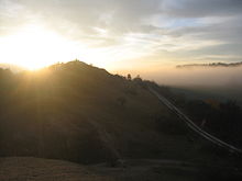
Sunrise over the
Ziegenberg hill itself, seen from the Struvenberg
26:
106:
102:
204:. Other areas will be left to develop perfectly naturally.
39:
124:Amongst the other plants that occur here are the
221:
219:
62:in central Germany. The ridge is a designated
8:
215:
50:is a low ridge between the villages of
230:Federal Agency for Nature Conservation
254:Landesverwaltungsamt Sachsen-Anhalt:
7:
172:Southern slopes of the Struvenberg
25:
321:Nature reserves in Saxony-Anhalt
1:
188:) and quarries established.
58:on the northern edge of the
164:Land use and nature reserve
95:Hercynian mountain building
347:
77:), bushes, pine woods and
256:Ziegenberg bei Heimburg.
154:Stemless carline thistle
173:
43:
32:
297:51.82883°N 10.88867°E
171:
38:
30:
272:Landesverwaltungsamt
142:Gentianopsis ciliata
140:), Fringed Gentian (
138:Prunella grandiflora
130:Pimpinella saxifraga
293: /
326:Blankenburg (Harz)
302:51.82883; 10.88867
174:
150:Bupleurum falcatum
44:
33:
146:Sickle hare's ear
16:(Redirected from
338:
308:
307:
305:
304:
303:
298:
294:
291:
290:
289:
286:
258:
252:
246:
238:
232:
223:
126:Burnet Saxifrage
75:Halbtrockenrasen
21:
346:
345:
341:
340:
339:
337:
336:
335:
311:
310:
301:
299:
295:
292:
287:
284:
282:
280:
279:
266:
261:
253:
249:
239:
235:
224:
217:
213:
166:
158:Carlina acaulis
134:Large Self-heal
115:
91:
23:
22:
15:
12:
11:
5:
344:
342:
334:
333:
328:
323:
313:
312:
277:
276:
265:
264:External links
262:
260:
259:
247:
233:
214:
212:
209:
165:
162:
114:
111:
90:
87:
64:nature reserve
60:Harz Mountains
24:
14:
13:
10:
9:
6:
4:
3:
2:
343:
332:
329:
327:
324:
322:
319:
318:
316:
309:
306:
275:
273:
268:
267:
263:
257:
251:
248:
244:
243:
237:
234:
231:
227:
222:
220:
216:
210:
208:
205:
203:
199:
198:forest steppe
195:
189:
187:
183:
179:
170:
163:
161:
159:
155:
151:
147:
143:
139:
135:
131:
127:
122:
120:
112:
110:
108:
104:
100:
96:
88:
86:
84:
80:
76:
72:
69:
65:
61:
57:
53:
49:
42:
37:
29:
19:
278:
271:
250:
241:
236:
226:Map services
206:
190:
185:
177:
175:
157:
149:
141:
137:
129:
123:
119:Linum leonii
118:
116:
92:
74:
52:Benzingerode
47:
45:
331:Wernigerode
300: /
202:sessile oak
186:Pinus nigra
99:muschelkalk
83:Struvenberg
79:wet meadows
41:Struvenberg
18:Ziegenberge
315:Categories
288:10°53.32′E
285:51°49.73′N
211:References
182:Black Pine
178:Struveburg
68:mesophytic
48:Ziegenberg
71:grassland
85:(291 m)
56:Heimburg
228:of the
89:Geology
152:) and
200:with
194:sheep
113:Flora
107:marl
105:and
103:silt
54:and
46:The
160:).
144:),
132:),
121:).
317::
218:^
109:.
274:)
184:(
156:(
148:(
136:(
128:(
73:(
20:)
Text is available under the Creative Commons Attribution-ShareAlike License. Additional terms may apply.