29:
295:
in order to provide enable trout to negotiate the river more easily. The project was a significant factor in the town of
Wernigerode being recognised for outstanding work in nature conservation as part of the competition to select the nation's "Conservation Capital"
341:
291:. To improve the ecological environment of the Zillierbach a project was carried out from 2000 to 2002 by the German Foundation for the Environment, which envisaged five weirs with
346:
Heidelberg wird
Bundeshauptstadt im Naturschutz 2007 - Rastatt, Wernigerode, Wettenberg und Nettersheim für herausragende Leistungen im kommunalen Naturschutz ebenso ausgezeichnet
279:, which features on the coat-of-arms of the town of Wernigerode as well as that of the district of Harz. Besides trout, the stream also supports the
131:
405:
400:
319:
410:
362:
420:
337:
415:
378:
267:). It drops through a vertical height of almost 400 metres (1,300 ft) from source to mouth.
240:
243:. In front of the settlement of Voigtstieg it is joined by another two smaller brooks. In the
51:
228:
382:
366:
314:
236:
223:. It is about 13 kilometres (8 mi) long. The stream rises on the western side of the
284:
216:
255:(Mill Valley) today. In its lower reaches before its mouth the stream is known as the
394:
280:
220:
56:
183:
275:
The
Zillierbach is home to a range of rare fish species, including the protected
292:
276:
248:
244:
232:
113:
97:
28:
146:
133:
288:
195:
359:
309:
260:
179:
117:
342:
Federal
Ministry for Environment, Nature Conservation and Nuclear Safety
212:
44:
375:
187:
208:
191:
227:
crags and runs initially southwards, then swings northeast at
231:. South of Drei Annen Hohne it picks up the waters of the
247:
the
Zillierbach powered the mills between Voigtstieg and
207:(until 1558 called the Zilgerbach) is a stream in the
376:
235:, its main tributary. The Zillierbach supplies the
175:
170:
162:
123:
106:
96:
79:
71:
62:
50:
40:
35:
21:
360:DBU project handout on the Zillierbach Project
251:. This section of the valley is still called
8:
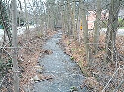
263:at Wernigerode northwest of the West Gate (
330:
18:
7:
14:
259:. The stream discharges into the
27:
320:List of rivers of Saxony-Anhalt
125: • coordinates
1:
63:Physical characteristics
298:Bundeshauptstadt Naturschutz
108: • location
81: • location
437:
92:
67:
26:
406:Rivers of Saxony-Anhalt
401:Tributaries of the Bode
166:13 km (8 mi)
85:Southeast side of the
211:mountains of central
369:(pdf file; 104 kB)
271:Habitat and ecology
171:Basin features
147:51.8344°N 10.7790°E
143: /
411:Rivers of the Harz
381:2021-02-25 at the
365:2011-11-20 at the
219:) in the state of
421:Rivers of Germany
201:
200:
428:
387:
372:
348:
335:
229:Drei Annen Hohne
158:
157:
155:
154:
153:
152:51.8344; 10.7790
148:
144:
141:
140:
139:
136:
82:
31:
19:
16:River in Germany
436:
435:
431:
430:
429:
427:
426:
425:
416:Harz (district)
391:
390:
385:
383:Wayback Machine
370:
367:Wayback Machine
356:
351:
344:of 29.10.2007:
336:
332:
328:
315:Zillierbach Dam
306:
273:
237:Zillierbach Dam
151:
149:
145:
142:
137:
134:
132:
130:
129:
126:
109:
80:
17:
12:
11:
5:
434:
432:
424:
423:
418:
413:
408:
403:
393:
392:
389:
388:
373:
355:
354:External links
352:
350:
349:
329:
327:
324:
323:
322:
317:
312:
305:
302:
272:
269:
199:
198:
177:
173:
172:
168:
167:
164:
160:
159:
127:
124:
121:
120:
110:
107:
104:
103:
100:
94:
93:
90:
89:
83:
77:
76:
73:
69:
68:
65:
64:
60:
59:
54:
48:
47:
42:
38:
37:
33:
32:
24:
23:
15:
13:
10:
9:
6:
4:
3:
2:
433:
422:
419:
417:
414:
412:
409:
407:
404:
402:
399:
398:
396:
384:
380:
377:
374:
368:
364:
361:
358:
357:
353:
347:
343:
339:
338:Press release
334:
331:
325:
321:
318:
316:
313:
311:
308:
307:
303:
301:
299:
294:
290:
286:
282:
278:
270:
268:
266:
262:
258:
254:
250:
246:
242:
238:
234:
230:
226:
222:
221:Saxony-Anhalt
218:
217:Harz district
214:
210:
206:
197:
193:
189:
185:
181:
178:
174:
169:
165:
161:
156:
128:
122:
119:
115:
111:
105:
101:
99:
95:
91:
88:
84:
78:
74:
70:
66:
61:
58:
57:Saxony-Anhalt
55:
53:
49:
46:
43:
39:
34:
30:
25:
20:
345:
333:
297:
293:fish ladders
274:
264:
256:
252:
225:Hohneklippen
224:
204:
202:
87:Hohneklippen
86:
386:(in German)
371:(in German)
277:brown trout
249:Wernigerode
245:Middle Ages
241:Elbingerode
233:Wormsgraben
205:Zillierbach
176:Progression
150: /
114:Wernigerode
22:Zillierbach
395:Categories
326:References
265:Westerntor
138:10°46′44″E
135:51°50′04″N
257:Flutrenne
253:Mühlental
196:North Sea
116:into the
379:Archived
363:Archived
310:Holtemme
304:See also
287:and the
261:Holtemme
180:Holtemme
118:Holtemme
36:Location
340:by the
285:gudgeon
213:Germany
45:Germany
41:Country
283:, the
281:minnow
163:Length
102:
75:
72:Source
289:loach
239:near
188:Saale
98:Mouth
52:State
209:Harz
203:The
192:Elbe
184:Bode
300:).
112:in
397::
194:→
190:→
186:→
182:→
296:(
215:(
Text is available under the Creative Commons Attribution-ShareAlike License. Additional terms may apply.