3822:(9.7 km) in Sarpy County and 9 mi (14 km) in Douglas County. A contiguous stretch of property damage occurred along a 8 mi (13 km) stretch. The swath of damage ranged from about 0.25–0.5 mi (0.40–0.80 km) wide, spanning two to six city blocks at a time. Across the roughly 2,000-block area impacted by the tornado, 287 homes were destroyed, 650 were heavily damaged, and 787 were moderately damaged; another 53 apartment buildings sustained damage. The damage rendered thousands of people homeless. The Nebraska governor's office estimated a damage toll of $ 150–200 million (1975 USD; equivalent to $ 0.8–1.1 billion in 2023), making the tornado the costliest tornado in U.S. history and the costliest natural disaster in Nebraska history at the time. Damage estimates ranged as high as $ 500 million (equivalent to $ 2.8 billion in 2023). Researcher
3852:
192:
3840:
3888:
3864:
3876:
3559:
310:, producing increasingly favorable conditions for storm formation. Ahead of the warm front, thunderstorms and cloud cover over southern Iowa and northern and central Missouri caused cooler conditions ahead of the warm front, reinforcing a strong temperature gradient across the front. This further enhanced the favorability of atmospheric conditions for storm development.
3810:, Lewis and Clark Junior High school, the First United Methodist Church, and the Temple Israel Jewish Synagogue. Two people were killed near the intersection of 69th and Maple streets. A police officer who had been tasked with following the tornado and communicating live updates reported that the tornado lifted near
805:
A strong tornado caused damage intermittently along its path, especially in western Pierce where homes were damaged, barns were destroyed, cars were tossed, power lines were toppled, and livestock were killed. The NCEI lists this tornado at F3 intensity, but it is assessed at F2 strength by
Grazulis.
367:
of vorticity in the mid- to upper-troposphere into the region. Many of the thunderstorms that produced tornadoes showed rapid growth on satellite imagery around the time of tornado development, indicative of the rapid rise of air. The thunderstorms were supported by the channel of moist air, tracking
3683:
A destructive tornado – at the time the costliest in U.S. history – impacted residential areas of west-central Omaha on the afternoon of May 6, tracking primarily south to north along 72nd Street. During the afternoon and evening, a tornado watch was in effect for
372:
on May 6, with large and strong tornadoes affecting eastern
Nebraska. All but one of the tornadoes had relatively short tracks, with their parent thunderstorms moving across the narrow corridor of moist air and the steep temperature gradient accompanying the warm front; the storm that produced
3821:
Approximately 30,000 people may have been in the path of the tornado. Three people were killed by the tornado and another 141 people were injured; of the injuries, 25 were considered serious injuries. The tornado's path was approximately 15 mi (24 km) long, with about 6 mi
3779:
near 84th Street, inflicting injuries on the highway and prompting the highway's closure. Beginning to track along and near 72nd Street, the tornado cut across the
Westgate subdivision, causing extensive damage and destroying Westgate Elementary School. Well-constructed homes were destroyed in the
3745:
publication for May 1975 indicates that the tornado touched down slightly later at around 4:33 p.m. This gave a nearly four hour leadtime between issuance of the tornado watch and tornado occurrence, and over an hour leadtime for the tornado warning. The tornado's path began in a largely
1057:
publication and the NCEI consider this event as two separate tornadoes focused in Bon Homme County. However, they are considered one event by
Grazulis, and the path was extended into Hutchinson County. Additionally, the NCEI lists this tornado at F1 intensity, but it is assessed at F2 strength by
363:, the office's first of the day. Between around 2–7 p.m., the squall line produced several damaging tornadoes in northeastern Nebraska. In the Omaha area, the development of thunderstorms was preceded by the movement of a comma-shaped area of cloudiness into the region, an indication of the
334:
soon developed along much of the cold front, with the strongest thunderstorms occurring near the intersection between the cold and warm fronts ahead of the low-pressure area and along the warm front, including the storm that eventually produced a destructive tornado in Omaha. Within this area,
704:
A violent tornado moved through Magnet on a southeasterly to northwesterly heading at around 2:15 p.m. CDT, damaging or destroying nearly every structure in town. The Magnet city hall was destroyed. Some homes were completely leveled. Cattle were killed, cars were thrown over 200 yd
155:, causing at least $ 150 million in damage and killing three people. It was at the time the costliest tornado in U.S. history, damaging over a thousand homes across a nearly 2,000-block area on its roughly 15 mi (24 km) long path. The tornado's damage was later rated F4 on the
1668:
A manufactured home was destroyed, and the occupant was severely injured after being tossed across the road. Portions of the home were scattered for 3 mi (4.8 km). Another house lost its roof and had its furniture tossed. The occupants were trapped and injured by a fallen tree.
3784:, blowing out windows and disheveling furniture; all 825 employees and patients of the hospital survived. Vehicles in the hospital parking lot were tossed and destroyed. Damage at the hospital amounted to around $ 5 million. The tornado narrowly avoided the
3788:
racetrack, forcing most of the 8,700 attendees at the racetrack that day into shelter. One person was killed while taking shelter at a restaurant at 78th and
Pacific streets. Numerous buildings sustained significant damage near the intersection of 72nd and
3767:
were reported falling from the sky over Omaha ahead of the tornado. The
Wentworth Apartments, the largest apartment complex in the Omaha area at the time, sustained severe damage with 70 percent of the complex's buildings destroyed. Parts of the roof of
163:, destroying or damaging nearly every building in the town. The tornadoes were produced by thunderstorms moving across a narrow region of warm and moist air that had advanced northwards into the Upper Midwest as a result of a strong area of
3975:
lists the tornado as having occurred between 4:33–4:50 p.m. However, reports from storm spotters and the
National Weather Service Disaster Survey Report on the tornado indicate that the tornado lasted from about 4:29 p.m. to
5225:(Satellite Applications Information Note). Satellite Applications Information Notes, October 1975 – December 1978. Scott Air Force Base, Illinois: National Environmental Satellite Service. pp. 85–86. 76/12
1745:
A farm co-op building had one of its sides knocked down and its roof ripped off and subsequently wrapped around a utility pole. A concession stand was destroyed, a warehouse was damaged, and several tree tops were twisted.
3801:
was lost, with 80 of the office's 90 cars destroyed. Some of the most severe damage associated with the tornado occurred after it crossed Dodge Street at around 4:45 p.m., with buildings reduced to rubble. The
321:
for much of the area in advance of the event at 12:37 p.m. May 6. The watch area was in effect from 2–8 p.m. and encompassed parts of eastern
Nebraska, northeastern Kansas, northwestern Missouri, western
3750:
and 132nd Street in northern Sarpy County. The first homes destroyed by the tornado were hit at around 4:35 p.m. Following initial reports of damage near the intersection of 96th and Q streets, Nebraska governor
2632:
Grain bins, a brick silo, and a machine shed were destroyed. The roof was ripped off a feeding shed. A garage was overturned. A home lost shingles and windows. This tornado is not listed in Thomas
Grazulis'
966:
An intense tornado caused extensive damage to farms and power lines. Multiple barns were leveled, and one home was reduced to two standing walls. Five hundred chickens were killed. One person was injured.
278: – Atmospheric Variability Experiments – sampled environmental conditions throughout the southwestern and southern United States during the eventual severe weather event. A
3851:
4885:
290:. During the morning hours, the broader wind pattern brought increasingly moist air in the lower troposphere into a narrow region encompassing eastern Nebraska, eastern Kansas, and northern
3806:
lost most of its roof and the
Downtowner Motor Inn suffered major damage. Extensive damage occurred along 72nd Street, with numerous homes and apartments severely damaged, along with
2947:
A strong tornado caused damage at six farms. A barn and a shed were destroyed. The roof and doors were ripped off a house, windows were blown out of a car, and two cows were killed.
3904:
620:
Numerous farm buildings were destroyed across four farms, and five cattle were killed. The NCEI lists this tornado at F0 intensity, but it is assessed at F2 strength by Grazulis.
3684:
parts of eastern Nebraska. Tornadoes were reported near several Nebraska communities during the early afternoon. The National Weather Service forecast office in Omaha issued two
5927:
1897:
Several pavilion shelters in Kemper Park were blown down. Playground equipment was damaged, power lines were toppled, and trees were uprooted. Some tree limbs fell onto a car.
5514:
3887:
3456:
campus, ripping the tops of elevator shafts and the top half of a nearby water tower. Numerous trees were snapped or twisted. This tornado is not listed in Thomas Grazulis'
3839:
3781:
198:
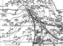
of the tornado outbreak region, with weather boundaries and weather observations at around 4 p.m. CDT May 6, including the eventual starting points of tornadoes
2133:
Two houses lost their roofs while a third was heavily damaged. Two chicken houses were destroyed and trees were uprooted, some of which fell on homes or blocked roads.
5851:
274:
were near 65 °F (18 °C) while they were below 20 °F (−7 °C) behind the cold front over western Kansas. An ongoing scientific field campaign run by
3402:
2822:
1847:
1494:
570:
3486:
3248:
2435:
Four manufactured homes were demolished, one was overturned, and eleven others were damaged. Two people were injured. This tornado is not listed in Thomas Grazulis'
2385:
2083:
832:
3172:
1236:
1084:
3017:
2897:
2746:
2582:
2310:
2235:
1772:
1618:
1402:
1003:
2667:
2465:
1999:
1695:
916:
755:
5932:
5922:
3327:
3097:
2159:
1544:
Numerous farm houses and outbuildings were damaged or destroyed over intermittent stretches of a tornado's path. This tornado is not listed in Thomas Grazulis'
1315:
1160:
654:
4743:
1923:
5669:
1452:
Numerous farm houses and outbuildings were damaged or destroyed. An aluminum silo was lofted 0.75 mi (1.21 km) away from a farmstead southwest of
373:
the long-track tornado moved parallel to the temperature gradient. The same weather system led to at least 19 tornadoes on May 7, including 10 in
5403:
5283:
5244:
5206:
5157:
5121:
5086:
5050:
5007:
4958:
5684:
3909:
3298:
A manufactured home was destroyed. A number of aircraft at a hangar were damaged at the Le Gros Airport. This tornado is not listed in Thomas Grazulis'
3147:
Six homes and four trailers were destroyed, including one trailer lofted to the tops of trees. Numerous trees were uprooted. Three people were injured.
3863:
3875:
3739:
The first confirmations of a tornado touching down were reported at around 4:29 p.m., leading to the activation of tornado sirens in Omaha. The
5507:
5253:
3915:
1469:
5649:
5689:
5659:
5483:
4862:
368:
north before eventually weakening after moving into cooler and drier air downwind. Twelve tornadoes ultimately occurred over the north-central
314:
299:
2717:
Some farm buildings, a barn, and a corn crib were destroyed. The roof of a home was damaged. This tornado is not listed in Thomas Grazulis'
330:; Omaha was also included within the watch area. The first indications of storm development were apparent in South Dakota by 11 a.m. A
302:
for the development of storms. Daytime heating and the increase in moisture with time within this narrow region, as well as a simultaneous
5674:
298:, each slowly moving. Warmer and drier air persisted in the mid-levels of the troposphere above this moist air, resulting in conditions
5500:
3390:
4674:
5907:
4828:
3085:
5452:
5837:
5679:
990:
191:
5917:
5881:
3763:, damaging neighborhoods and businesses near 84th and L streets. Large airborne debris was observed near 72nd and L streets.
1606:
1072:
986:
246:
on May 6, the area of low pressure was centered over southwestern South Dakota, with a central air pressure of 991
5902:
5844:
3807:
3756:
3474:
1987:
3685:
3315:
2067:
1835:
5015:
Dewey, Kenneth; Mogil, H. Michael (June 23, 2017). "The Weather and Climate of Nebraska: The Heartland of Extremes".
5292:
3700:
were deployed following the watch and warning issuances between around 1–2 p.m. At 4:09 p.m., a volunteer
5912:
4493:. No. 108. Columbus, Nebraska. United Press International. May 17, 2024. p. 1 – via Newspapers.com.
3960:
3733:
3725:
3453:
2982:
2453:
2223:
2147:
1760:
1583:
1478:
1386:
558:
531:
5238:
5151:
5080:
4609:
4380:
3803:
3067:
A tornado destroyed a home and then moved through forested areas. This tornado is not listed in Thomas Grazulis'
2071:
1911:
1683:
1148:
553:
5388:
5363:
5191:
5166:
4992:
4967:
4943:
4918:
4807:
4782:
4565:
4530:
4505:
270:
to the east and a dry and cooler airmass to the west. Ahead of the cold front over eastern Kansas and Nebraska,
3689:
3236:
3160:
3005:
2298:
2058:
1830:
1303:
900:
352:
195:
2062:
5341:
5130:
5059:
3794:
735:
714:
638:
307:
231:
3775:
The twister's path then curved north towards and over west-central sections of the city of Omaha, crossing
5546:
3717:
3385:
1299:
1224:
1067:
980:
904:
743:
710:
642:
5397:
5277:
5200:
5115:
5044:
5001:
4952:
3938:
3709:
3697:
3604:
3584:
3469:
3231:
2570:
1755:
1482:
1390:
976:
820:
739:
730:
243:
4783:"Tornadoes, Tornadic Thunderstorms, and Photogrammetry: A Review of the Contributions by T. T. Fujita"
5467:
5422:
5375:
5343:
Impact of Short Interval SMS Digital Data on Wind Vector Determination for a Severe Local Storms Area
5320:
5178:
5024:
4979:
4930:
4794:
4517:
3747:
3155:
2810:
2528:
2448:
2218:
2142:
1982:
1906:
1678:
815:
219:
93:
5094:
Hill, Kelly; Turner, Robert E. (February 1977). "NASA's Atmospheric Variability Experiments (AVE)".
343:
of winds near the surface were higher than surrounding areas. The squall line was first apparent on
5871:
5644:
3769:
2885:
2655:
1219:
360:
3536:
Six electrical transmission towers were destroyed. This tornado is not listed in Thomas Grazulis'
2552:
Small buildings and sheds were blown down, and trees were uprooted. This tornado is listed in the
5654:
5103:
3823:
3785:
3764:
3000:
2734:
2373:
1973:
Trees were uprooted, some of which fell on a manufactured home and a car, injuring the occupant.
1601:
223:
5860:
3760:
2805:
2368:
895:
891:
549:
255:
207:
164:
138:
2872:
Two hog houses and a barn were destroyed. Two hogs were killed. Trees were uprooted as well.
5430:
5383:
5328:
5186:
5032:
4987:
4938:
4802:
4744:"'Just gone, just everything leveled': 1975 TV coverage depicts horror of the Omaha tornado"
4525:
3310:
3080:
1453:
1381:
726:
633:
629:
340:
294:. This corridor of moist air was bounded to the west by the cold front and to the east by a
203:
160:
5664:
5456:
4682:
3729:
3377:
An auto repair shop and several manufactured homes were damaged. Two people were injured.
1294:
1143:
283:
279:
152:
5426:
5379:
5324:
5182:
5028:
4983:
4934:
4798:
4595:. No. 127. Council Bluffs, Iowa. May 7, 1975. p. 3 – via Newspapers.com.
4521:
3558:
717:
counties, estimated that the tornado that struck Magnet was stronger the Omaha tornado.
2565:
2293:
1377:
287:
4886:"Back in the day, May 6, 1975: Tornado slashes nine-mile scar into the heart of Omaha"
3608:
3588:
3222:
A brief tornado uprooted trees, one of which fell onto a home, injuring the occupant.
709:, who later photographed cycloidal scar patterns left by the tornado in cornfields in
5896:
5449:
3776:
3752:
3713:
3701:
3693:
2880:
2729:
2523:
344:
318:
251:
148:
104:
5820:
3720:, following the report. Additional reports of funnel clouds and the appearance of a
147:
During the afternoon of May 6, 1975, at least 12 tornadoes touched down in the
5332:
5311:
Ostby, Frederick P.; Pearson, Allen (February 1976). "The Tornado Season of 1975".
3827:
3790:
3705:
3631:
2964:
2646:
2458:
2228:
2152:
1992:
1765:
1565:
1077:
996:
563:
513:
391:
374:
369:
215:
168:
156:
116:
56:
5434:
5036:
4855:
705:(180 m), and power lines were toppled. One person was injured. Meteorologist
5217:
3811:
3798:
2650:
2076:
1916:
1840:
1688:
1473:
331:
235:
227:
180:
124:
5492:
5364:"Short-Interval SMS Wind Vector Determinations for a Severe Local Storms Area"
3741:
706:
303:
295:
259:
247:
3502:
3488:
3418:
3404:
3343:
3329:
3264:
3250:
3188:
3174:
3113:
3099:
3033:
3019:
2913:
2899:
2838:
2824:
2762:
2748:
2683:
2669:
2598:
2584:
2481:
2467:
2401:
2387:
2326:
2312:
2251:
2237:
2175:
2161:
2099:
2085:
2015:
2001:
1939:
1925:
1863:
1849:
1788:
1774:
1711:
1697:
1634:
1620:
1510:
1496:
1418:
1404:
1331:
1317:
1252:
1238:
1176:
1162:
1100:
1086:
1019:
1005:
932:
918:
848:
834:
771:
757:
670:
656:
586:
572:
5829:
4610:"Storm Data and Unusual Weather Phenomena with Late Reports and Corrections"
4381:"Storm Data and Unusual Weather Phenomena with Late Reports and Corrections"
3956:
3721:
3479:
3395:
3320:
3241:
3165:
3090:
3010:
1611:
364:
336:
327:
271:
172:
120:
882:
Farm buildings, irrigation equipment, and trees were sporadically damaged.
171:. Additional tornadoes on May 7 and May 8, including several in
5816:
4506:"Tornadoes and Downbursts in the Context of Generalized Planetary Scales"
3692:, including the Omaha area, during the afternoon of May 6. Teams of
1308:
1229:
1153:
909:
825:
748:
647:
348:
291:
239:
211:
112:
5107:
4235:
4233:
1210:
A brief tornado caused damage to trees and farm buildings on two farms.
286:, at 7 a.m. sampled atmospheric conditions moderately conducive to
5524:
5167:"A Study of Tornadic Thunderstorm Interactions with Thermal Boundaries"
267:
347:
at around 1 p.m., extending from central South Dakota to central
5817:
National Centers for Environmental Information: Storm Events Database
4721:
263:
5138:(Contractor Report). National Oceanic and Atmospheric Administration
4623:(6). National Centers for Environmental Information: 2–41. June 1975
4120:
4118:
4116:
4724:. Valley, Nebraska: National Weather Service Omaha/Valley, Nebraska
4394:(5). National Centers for Environmental Information: 2–27. May 1975
4250:
4248:
4169:
4167:
4165:
5219:
An Example of Dry Line Convective Development: "The Omaha Tornado"
4163:
4161:
4159:
4157:
4155:
4153:
4151:
4149:
4147:
4145:
2971:
2968:
2533:
2378:
2303:
1572:
1569:
520:
517:
190:
176:
128:
5254:"A Synoptic Analysis of the 6–7 May 1975 Omaha Tornado Outbreak"
3912: – produced several significant tornadoes in the Omaha area
2890:
2815:
2739:
2660:
2575:
1487:
1395:
378:
356:
323:
275:
108:
5833:
5496:
3732:
for Sarpy and eastern Douglas counties in Nebraska and western
262:
extended from the low-pressure system southwestward to central
4966:
Chang, C. B.; Perkey, D. J.; Kreitzberg, C. W. (August 1981).
4856:"Rationale for Wind-Borne Missile Criteria for DOE Facilities"
3818:
listed the tornado as dissipating after around 4:50 p.m.
5291:
National Weather Service Central Region Headquarters (1975).
3759:. Moving northeast, the tornado struck parts of northwestern
5132:
Interactions Between Convective Storms and their Environment
4474:
Wolf, Maxine (May 7, 2024). "Twister Levels Little Magnet".
4001:
3999:
3997:
3995:
3993:
5389:
10.1175/1520-0493(1980)108<1407:SISWVD>2.0.CO;2
5192:
10.1175/1520-0493(1980)108<0322:ASOTTI>2.0.CO;2
5165:—; Hoxit, L. Ray; Chappell, Charles F. (March 1980).
4993:
10.1175/1520-0469(1981)038<1601:ANCSOT>2.0.CO;2
4944:
10.1175/1520-0450(1979)018<0502:TIADFS>2.0.CO;2
4808:
10.1175/1520-0477(2001)082<0073:TTTAPA>2.3.CO;2
4531:
10.1175/1520-0469(1981)038<1511:TADITC>2.0.CO;2
4091:
4089:
151:. The costliest of these tornadoes struck parts of western
4919:"Thunderstorm Intensity as Determined from Satellite Data"
4478:. Lincoln, Nebraska. p. 8 – via Newspapers.com.
3959:
where the tornado touched down; however, all times are in
5129:
Maddox, R. A.; Hoxit, L. R.; Chappell, C. F. (May 1979).
4968:"A Numerical Case Study of the Squall Line of 6 May 1975"
4781:
Forbes, Gregory S.; Bluestein, Howard B. (January 2001).
3826:
estimated that the tornado caused F4-rated damage on the
5821:
Storm Prediction Center: The 10 Costliest U.S. Tornadoes
5349:(Technical Memorandum). Greenbelt, Maryland: NASA. 79714
4591:
Written at Beebeetown, Iowa. "Beebeetown Farm Struck".
3918: – included a damaging and deadly tornado in Omaha
3905:
List of North American tornadoes and tornado outbreaks
2515:
A brief tornado was reported to the sheriff's office.
2285:
A brief tornado was reported to the sheriff's office.
2209:
A brief tornado was reported to the sheriff's office.
266:, demarcating the boundary between a moist and warmer
4835:. New York. Associated Press. May 7, 1974. p. 24
4239:
4052:
4050:
1560:
List of confirmed tornadoes – Wednesday, May 7, 1975
1286:
Trees, power lines, and farm buildings were damaged.
3780:
neighborhood. At 4:40 p.m., the tornado struck
2959:
List of confirmed tornadoes – Thursday, May 8, 1975
4829:"Omaha Tornadoes Kill 3; Damage Is Put in Millions"
4290:
4224:
4124:
3669:
3659:
3651:
3643:
3638:
3623:
3615:
3595:
3575:
3568:
2963:
1564:
512:
508:List of confirmed tornadoes – Tuesday, May 6, 1975
455:
One tornado is confirmed, but its rating is unknown
306:of air in the upper-troposphere, further increased
222:. The combination of the low-pressure system and a
100:
88:
80:
72:
67:
52:
44:
39:
31:
24:
5298:(Disaster Survey Report). National Weather Service
4884:
4768:
4703:
4254:
4185:
4173:
3797:. Most of the mail carrier fleet at a nearby U.S.
3728:prompted the Omaha office to issue a pre-prepared
4917:Adler, Robert F.; Fenn, Douglas D. (April 1979).
4822:
4820:
4818:
4750:. Omaha, Nebraska: Hearst Television. May 6, 2021
4668:
4666:
4664:
4662:
4660:
4658:
3696:associated with the National Weather Service and
1456:. This tornado is not listed in Thomas Grazulis'
4656:
4654:
4652:
4650:
4648:
4646:
4644:
4642:
4640:
4638:
5177:(3). American Meteorological Society: 322–336.
5096:Bulletin of the American Meteorological Society
4787:Bulletin of the American Meteorological Society
4469:
4467:
326:, southeastern South Dakota, and southwestern
183:, were associated with the same storm system.
5845:
5508:
5061:Kinetic Energy Budgets in Areas of Convection
4559:
4557:
4555:
4553:
4551:
4549:
4547:
4545:
4543:
4541:
2049:A brief tornado caused some property damage.
1822:A brief tornado caused some property damage.
8:
4451:
4449:
4447:
4445:
4443:
4441:
4439:
4437:
4435:
4433:
4431:
4429:
4005:
3951:
3949:
3947:
3551:
19:
5928:1975 natural disasters in the United States
5252:Moore, James T.; Elkins, Harold A. (1985).
4427:
4425:
4423:
4421:
4419:
4417:
4415:
4413:
4411:
4409:
4197:
4107:
4095:
4080:
4068:
4017:
5852:
5838:
5830:
5533:
5515:
5501:
5493:
5461:
4716:
4714:
4712:
4278:
4029:
3893:Downtowner Motor Inn (near 72nd and Dodge)
3557:
3550:
2957:
1558:
506:
18:
5387:
5190:
4991:
4942:
4806:
4604:
4602:
4529:
4375:
4373:
4371:
4369:
4367:
4365:
4363:
4361:
4359:
4357:
4355:
4353:
4351:
4349:
4347:
4345:
4343:
4341:
4339:
4337:
4335:
4333:
4331:
4329:
4327:
4325:
4323:
4321:
4319:
4266:
2796:A tornado touched down in an open field.
5264:(1). National Weather Association: 39–56
4317:
4315:
4313:
4311:
4309:
4307:
4305:
4303:
4301:
4299:
4041:
2990:
2987:
2980:
2977:
2974:
2360:An F1 tornado caused damage in Leander.
1591:
1588:
1581:
1578:
1575:
539:
536:
529:
526:
523:
458:
388:
3989:
3930:
3916:Tornado outbreak sequence of March 1913
3857:Westgate subdivision near Interstate 80
3832:
3534:
3450:
3375:
3296:
3220:
3145:
3065:
2945:
2870:
2794:
2715:
2630:
2550:
2513:
2433:
2358:
2283:
2207:
2131:
2047:
1971:
1895:
1820:
1743:
1666:
1542:
1450:
1363:
1284:
1208:
1132:
1053:Small farm buildings were damaged. The
1051:
964:
880:
803:
702:
618:
5402:: CS1 maint: ref duplicates default (
5395:
5282:: CS1 maint: ref duplicates default (
5275:
5243:: CS1 maint: ref duplicates default (
5236:
5205:: CS1 maint: ref duplicates default (
5198:
5156:: CS1 maint: ref duplicates default (
5149:
5120:: CS1 maint: ref duplicates default (
5113:
5085:: CS1 maint: ref duplicates default (
5078:
5049:: CS1 maint: ref duplicates default (
5042:
5006:: CS1 maint: ref duplicates default (
4999:
4957:: CS1 maint: ref duplicates default (
4950:
4863:Lawrence Livermore National Laboratory
4572:. Omaha, Nebraska: Scripps Local Media
4212:
4136:
4056:
315:National Severe Storms Forecast Center
4854:McDonald, James R. (September 1999).
3910:Tornado outbreak of April 26–28, 2024
3464:
3381:
3306:
3226:
3151:
3075:
2995:
2876:
2800:
2725:
2641:
2560:
2519:
2443:
2364:
2289:
2213:
2137:
2053:
1977:
1901:
1826:
1750:
1673:
1596:
1464:
1372:
1290:
1214:
1138:
1062:
971:
886:
810:
721:
624:
544:
355:office in Omaha received a report of
7:
5933:May 1975 events in the United States
5923:Natural disasters in Omaha, Nebraska
5340:Peslen, Cynthia A. (February 1979).
3746:rural area near the intersection of
1366:
5475:Costliest U.S. tornadoes on Record
4972:Journal of the Atmospheric Sciences
4510:Journal of the Atmospheric Sciences
4504:Fujita, T. Theodore (August 1981).
4240:Chang, Perkey & Kreitzberg 1981
1134:Small farm buildings were damaged.
5058:Fuelberg, Henry E. (August 1979).
3845:Ralston area near Bay Meadows Park
3834:Damage caused by the Omaha tornado
14:
5685:Hackleburg–Phil Campbell, Alabama
5216:Miller, Joseph A. (August 1979).
4681:. Omaha, Nebraska. Archived from
4566:"May 6, 1975 | The Omaha Tornado"
4291:Maddox, Hoxit & Chappell 1980
4225:Maddox, Hoxit & Chappell 1980
4125:Maddox, Hoxit & Chappell 1979
3955:All dates are based on the local
3772:were peeled away by the twister.
3665:$ 0.8–1.1 billion (2023 USD)
3663:$ 150–200 million (1975 USD)
2556:publication but not by the NCEI.
159:. Another F4 tornado struck
3886:
3874:
3862:
3850:
3838:
351:. At around 1:15 p.m., the
61:
5067:(Contractor Report). NASA. 3166
4883:Jones, Sheritha (May 6, 2022).
4458:Significant Tornadoes 1974–2022
2935:
2860:
2708:
1535:
1532:
1443:
1440:
1367:See the section on this tornado
1353:
1047:
1044:
985:
974:
957:
954:
873:
796:
793:
608:
206:was associated with an intense
5333:10.1080/00431672.1976.10543939
5293:The Omaha Tornado: May 6, 1975
4923:Journal of Applied Meteorology
4673:Gaarder, Nancy (May 2, 2015).
4564:Meyer, Joseph (May 17, 2024).
4489:"Tornadoes in 3 other towns".
1:
5675:Oklahoma City metro, Oklahoma
5435:10.1080/00431672.1975.9931760
5037:10.1080/00431672.2017.1321919
3600:
3580:
4827:Written at Omaha, Nebraska.
3757:Nebraska Army National Guard
3686:severe thunderstorm warnings
3290:0.25 mi (0.40 km)
3214:0.75 mi (1.21 km)
1889:0.25 mi (0.40 km)
1737:0.25 mi (0.40 km)
496:Data from the NCEI database
5421:(4): 178–195. August 1975.
3444:6.2 mi (10.0 km)
3369:0.5 mi (0.80 km)
1965:9.7 mi (15.6 km)
874:5.4 mi (8.7 km)‡
234:in the lower levels of the
62:
20:1975 Omaha tornado outbreak
16:37-tornado outbreak in 1975
5949:
5455:December 20, 2013, at the
5450:Black Tuesday: May 6, 1975
5362:— (September 1980).
3961:Coordinated Universal Time
3736:in Iowa at 4:14 p.m.
3454:Louisiana State University
2125:5.4 mi (8.7 km)
1660:5.6 mi (9.0 km)
1202:3.4 mi (5.5 km)
1126:5.4 mi (8.7 km)
476:Data from Thomas Grazulis
5867:
5861:Tornado outbreaks of 1975
5811:
5531:
5480:
5473:
5464:
3881:West Omaha Postal Station
3814:at around 4:58 p.m.
3804:Omaha Community Playhouse
3677:
3628:
3563:Path of the Omaha tornado
3556:
3535:
3451:
3376:
3297:
3221:
3146:
3066:
2946:
2871:
2795:
2716:
2709:12 mi (19 km)※
2631:
2551:
2514:
2434:
2359:
2284:
2208:
2132:
2128:150 yd (140 m)
2048:
1972:
1968:440 yd (400 m)
1896:
1821:
1744:
1667:
1543:
1451:
1447:500 yd (460 m)
1364:
1360:250 yd (230 m)
1285:
1209:
1133:
1052:
1045:20 mi (32 km)†
965:
961:150 yd (140 m)
958:25 mi (40 km)†
881:
804:
797:43 mi (69 km)†
703:
699:300 yd (270 m)
619:
492:
480:
472:
467:
464:
418:
415:
412:
409:
406:
403:
400:
397:
220:upper-tropospheric trough
134:
92:≳$ 15 million (1975
5908:F4 tornadoes by location
4722:"May 1975 Omaha Tornado"
4593:Council Bluffs Nonpareil
4006:Ostby & Pearson 1975
3690:Douglas County, Nebraska
3142:100 yd (91 m)
3139:1 mi (1.6 km)
2939:10 mi (16 km)
1536:13 mi (21 km)
1444:11 mi (18 km)
1357:10 mi (16 km)
1278:3 mi (4.8 km)
1048:80 yd (73 m)†
696:19 mi (31 km)
612:12 mi (19 km)
390:Confirmed tornadoes by
353:National Weather Service
196:Surface weather analysis
5556:Inflation-adjusted cost
5258:National Weather Digest
4769:NWS Central Region 1975
4704:NWS Central Region 1975
4255:NWS Central Region 1975
4186:NWS Central Region 1975
4174:NWS Central Region 1975
4108:Moore & Elkins 1985
4096:Moore & Elkins 1985
4081:Moore & Elkins 1985
4069:Moore & Elkins 1985
4018:Moore & Elkins 1985
3941:unless otherwise noted.
3795:Nebraska Furniture Mart
3452:A tornado impacted the
3447:50 yd (46 m)
3430:Baton Rouge (May 8, F2)
3372:50 yd (46 m)
3293:50 yd (46 m)
2850:Grand River (May 7, F2)
2111:Eastabuchie (May 7, F1)
1892:18 yd (16 m)
1875:Hattiesburg (May 7, F1)
1740:60 yd (55 m)
1522:Honey Creek (May 6, F2)
1281:80 yd (73 m)
1205:17 yd (16 m)
1129:33 yd (30 m)
877:30 yd (27 m)
800:90 yd (82 m)
615:50 yd (46 m)
598:Chamberlain (May 6, F2)
308:atmospheric instability
187:Meteorological synopsis
5368:Monthly Weather Review
5272:– via CiteSeerX.
5171:Monthly Weather Review
4279:Dewey & Mogil 2017
4030:Hill & Turner 1977
3718:Sarpy County, Nebraska
3570:Meteorological history
3514:Greensburg (May 8, F2)
3276:Estherwood (May 8, F2)
2413:Nolanville (May 7, F2)
860:Bloomfield (May 6, F0)
224:ridge of high pressure
199:
26:Meteorological history
5918:Tornadoes in Nebraska
4267:Adler & Fenn 1979
3939:Central Daylight Time
3808:Creighton Prep School
3782:Bergan Mercy Hospital
3710:Springfield, Nebraska
3704:reported an emerging
3698:Offutt Air Force Base
3599:c. May 15, 1975
3538:Significant Tornadoes
3458:Significant Tornadoes
3300:Significant Tornadoes
3200:Mansfield (May 8, F1)
3069:Significant Tornadoes
2719:Significant Tornadoes
2635:Significant Tornadoes
2437:Significant Tornadoes
1546:Significant Tornadoes
1458:Significant Tornadoes
1264:Waterbury (May 6, F0)
300:potentially favorable
194:
5903:F4 tornadoes by date
5690:Wichita Falls, Texas
5680:Nashville, Tennessee
4456:Thomas P. Grazulis.
3748:Nebraska Highway 370
3734:Pottawattamie County
2610:Dow City (May 7, F2)
1430:Crescent (May 6, F2)
1112:Scotland (May 6, F0)
208:area of low pressure
5650:Tuscaloosa, Alabama
5559:(millions 2023 USD)
5427:1975Weawi..28d.178.
5380:1980MWRv..108.1407P
5325:1976Weawi..29a..16O
5183:1980MWRv..108..322M
5029:2017Weawi..70d..12D
4984:1981JAtS...38.1601C
4935:1979JApMe..18..502A
4799:2001BAMS...82...73F
4685:on November 9, 2020
4522:1981JAtS...38.1511F
3869:Westgate Elementary
3770:Ralston High School
3716:were activated for
3553:
3498: /
3414: /
3339: /
3260: /
3184: /
3109: /
3045:Florien (May 8, F2)
3029: /
2960:
2925:Osceola (May 7, F2)
2909: /
2834: /
2774:Creston (May 7, F0)
2758: /
2679: /
2594: /
2477: /
2397: /
2338:Leander (May 7, F1)
2322: /
2247: /
2171: /
2095: /
2011: /
1951:Richton (May 7, F1)
1935: /
1859: /
1800:Midland (May 7, F1)
1784: /
1723:Natchez (May 7, F1)
1707: /
1646:Pioneer (May 7, F2)
1630: /
1561:
1506: /
1414: /
1327: /
1248: /
1172: /
1096: /
1031:Tyndall (May 6, F1)
1015: /
944:Stanton (May 6, F3)
928: /
844: /
767: /
666: /
582: /
509:
484:Data from the 1975
461:
394:
385:Confirmed tornadoes
21:
5523:10 costliest U.S.
4891:Omaha World-Herald
4833:The New York Times
4679:Omaha World-Herald
4675:"Tracking a beast"
3824:Thomas P. Grazulis
3619:17–29 minutes
3579:May 15, 1975
2958:
2695:Harlan (May 7, F2)
2493:Pierre (May 7, F0)
2263:Pierre (May 7, F0)
2187:Pierre (May 7, F0)
2027:Wendte (May 7, F1)
1559:
783:Pierce (May 6, F2)
682:Magnet (May 6, F4)
507:
459:
389:
200:
5913:Tornadoes of 1975
5890:
5889:
5827:
5826:
5806:
5805:
5560:
5553:
5491:
5490:
5484:Wichita Falls, TX
5481:Succeeded by
4893:. Omaha, Nebraska
4706:, pp. 1, C1.
4491:Columbus Telegram
4460:. pp. 22–23.
4139:, pp. 85–86.
4083:, pp. 43–44.
3937:All times are in
3681:
3680:
3544:
3543:
3355:Duson (May 8, F1)
3125:Welsh (May 8, F2)
2951:
2950:
1552:
1551:
1343:Omaha (May 6, F4)
1188:Colon (May 6, F0)
500:
499:
460:Color/symbol key
449:
448:
317:(NSSFC) issued a
242:. At 7 a.m.
218:beneath a strong
145:
144:
139:Tornadoes of 1975
5940:
5854:
5847:
5840:
5831:
5715:October 20, 2019
5645:Joplin, Missouri
5558:
5551:
5534:
5517:
5510:
5503:
5494:
5465:Preceded by
5462:
5438:
5407:
5401:
5393:
5391:
5374:(9): 1407–1418.
5358:
5356:
5354:
5348:
5336:
5307:
5305:
5303:
5297:
5287:
5281:
5273:
5271:
5269:
5248:
5242:
5239:cite tech report
5234:
5232:
5230:
5224:
5210:
5204:
5196:
5194:
5161:
5155:
5152:cite tech report
5147:
5145:
5143:
5137:
5125:
5119:
5111:
5090:
5084:
5081:cite tech report
5076:
5074:
5072:
5066:
5054:
5048:
5040:
5011:
5005:
4997:
4995:
4978:(8): 1601–1615.
4962:
4956:
4948:
4946:
4903:
4902:
4900:
4898:
4888:
4880:
4874:
4873:
4871:
4869:
4860:
4851:
4845:
4844:
4842:
4840:
4824:
4813:
4812:
4810:
4778:
4772:
4766:
4760:
4759:
4757:
4755:
4740:
4734:
4733:
4731:
4729:
4718:
4707:
4701:
4695:
4694:
4692:
4690:
4670:
4633:
4632:
4630:
4628:
4614:
4606:
4597:
4596:
4588:
4582:
4581:
4579:
4577:
4561:
4536:
4535:
4533:
4516:(8): 1511–1534.
4501:
4495:
4494:
4486:
4480:
4479:
4476:The Lincoln Star
4471:
4462:
4461:
4453:
4404:
4403:
4401:
4399:
4385:
4377:
4294:
4288:
4282:
4276:
4270:
4264:
4258:
4252:
4243:
4237:
4228:
4222:
4216:
4210:
4204:
4195:
4189:
4183:
4177:
4171:
4140:
4134:
4128:
4122:
4111:
4105:
4099:
4093:
4084:
4078:
4072:
4066:
4060:
4054:
4045:
4039:
4033:
4027:
4021:
4015:
4009:
4003:
3977:
3970:
3964:
3963:for consistency.
3953:
3942:
3935:
3890:
3878:
3866:
3854:
3842:
3793:, including the
3670:Houses destroyed
3602:
3582:
3571:
3561:
3554:
3522:
3521:
3519:
3518:
3517:
3515:
3510:
3509:
3504:
3499:
3496:
3495:
3494:
3491:
3438:
3437:
3435:
3434:
3433:
3431:
3426:
3425:
3420:
3415:
3412:
3411:
3410:
3407:
3391:East Baton Rouge
3363:
3362:
3360:
3359:
3358:
3356:
3351:
3350:
3345:
3340:
3337:
3336:
3335:
3332:
3284:
3283:
3281:
3280:
3279:
3277:
3272:
3271:
3266:
3261:
3258:
3257:
3256:
3253:
3208:
3207:
3205:
3204:
3203:
3201:
3196:
3195:
3190:
3185:
3182:
3181:
3180:
3177:
3133:
3132:
3130:
3129:
3128:
3126:
3121:
3120:
3115:
3110:
3107:
3106:
3105:
3102:
3053:
3052:
3050:
3049:
3048:
3046:
3041:
3040:
3035:
3030:
3027:
3026:
3025:
3022:
2972:County / Parish
2961:
2933:
2932:
2930:
2929:
2928:
2926:
2921:
2920:
2915:
2910:
2907:
2906:
2905:
2902:
2858:
2857:
2855:
2854:
2853:
2851:
2846:
2845:
2840:
2835:
2832:
2831:
2830:
2827:
2782:
2781:
2779:
2778:
2777:
2775:
2770:
2769:
2764:
2759:
2756:
2755:
2754:
2751:
2703:
2702:
2700:
2699:
2698:
2696:
2691:
2690:
2685:
2680:
2677:
2676:
2675:
2672:
2618:
2617:
2615:
2614:
2613:
2611:
2606:
2605:
2600:
2595:
2592:
2591:
2590:
2587:
2501:
2500:
2498:
2497:
2496:
2494:
2489:
2488:
2483:
2482:44.75°N 100.80°W
2478:
2475:
2474:
2473:
2470:
2421:
2420:
2418:
2417:
2416:
2414:
2409:
2408:
2403:
2398:
2395:
2394:
2393:
2390:
2346:
2345:
2343:
2342:
2341:
2339:
2334:
2333:
2328:
2323:
2320:
2319:
2318:
2315:
2271:
2270:
2268:
2267:
2266:
2264:
2259:
2258:
2253:
2252:44.63°N 100.13°W
2248:
2245:
2244:
2243:
2240:
2195:
2194:
2192:
2191:
2190:
2188:
2183:
2182:
2177:
2176:44.70°N 100.40°W
2172:
2169:
2168:
2167:
2164:
2119:
2118:
2116:
2115:
2114:
2112:
2107:
2106:
2101:
2096:
2093:
2092:
2091:
2088:
2035:
2034:
2032:
2031:
2030:
2028:
2023:
2022:
2017:
2016:44.25°N 100.60°W
2012:
2009:
2008:
2007:
2004:
1959:
1958:
1956:
1955:
1954:
1952:
1947:
1946:
1941:
1936:
1933:
1932:
1931:
1928:
1883:
1882:
1880:
1879:
1878:
1876:
1871:
1870:
1865:
1860:
1857:
1856:
1855:
1852:
1808:
1807:
1805:
1804:
1803:
1801:
1796:
1795:
1790:
1789:44.07°N 100.90°W
1785:
1782:
1781:
1780:
1777:
1731:
1730:
1728:
1727:
1726:
1724:
1719:
1718:
1713:
1708:
1705:
1704:
1703:
1700:
1654:
1653:
1651:
1650:
1649:
1647:
1642:
1641:
1636:
1631:
1628:
1627:
1626:
1623:
1573:County / Parish
1562:
1530:
1529:
1527:
1526:
1525:
1523:
1518:
1517:
1512:
1507:
1504:
1503:
1502:
1499:
1454:Beebeetown, Iowa
1438:
1437:
1435:
1434:
1433:
1431:
1426:
1425:
1420:
1415:
1412:
1411:
1410:
1407:
1351:
1350:
1348:
1347:
1346:
1344:
1339:
1338:
1333:
1328:
1325:
1324:
1323:
1320:
1272:
1271:
1269:
1268:
1267:
1265:
1260:
1259:
1254:
1249:
1246:
1245:
1244:
1241:
1196:
1195:
1193:
1192:
1191:
1189:
1184:
1183:
1178:
1173:
1170:
1169:
1168:
1165:
1120:
1119:
1117:
1116:
1115:
1113:
1108:
1107:
1102:
1097:
1094:
1093:
1092:
1089:
1039:
1038:
1036:
1035:
1034:
1032:
1027:
1026:
1021:
1016:
1013:
1012:
1011:
1008:
952:
951:
949:
948:
947:
945:
940:
939:
934:
929:
926:
925:
924:
921:
868:
867:
865:
864:
863:
861:
856:
855:
850:
845:
842:
841:
840:
837:
791:
790:
788:
787:
786:
784:
779:
778:
773:
768:
765:
764:
763:
760:
690:
689:
687:
686:
685:
683:
678:
677:
672:
667:
664:
663:
662:
659:
606:
605:
603:
602:
601:
599:
594:
593:
588:
583:
580:
579:
578:
575:
521:County / Parish
510:
462:
395:
238:towards eastern
210:that moved from
204:tornado outbreak
161:Magnet, Nebraska
40:Tornado outbreak
27:
22:
5948:
5947:
5943:
5942:
5941:
5939:
5938:
5937:
5893:
5892:
5891:
5886:
5863:
5858:
5828:
5823:
5807:
5802:
5766:
5730:
5694:
5655:Moore, Oklahoma
5638:
5557:
5550:
5527:
5521:
5487:
5477:
5471:
5457:Wayback Machine
5446:
5441:
5412:
5394:
5361:
5352:
5350:
5346:
5339:
5310:
5301:
5299:
5295:
5290:
5274:
5267:
5265:
5251:
5235:
5228:
5226:
5222:
5215:
5197:
5164:
5148:
5141:
5139:
5135:
5128:
5112:
5093:
5077:
5070:
5068:
5064:
5057:
5041:
5014:
4998:
4965:
4949:
4916:
4912:
4907:
4906:
4896:
4894:
4882:
4881:
4877:
4867:
4865:
4858:
4853:
4852:
4848:
4838:
4836:
4826:
4825:
4816:
4780:
4779:
4775:
4767:
4763:
4753:
4751:
4742:
4741:
4737:
4727:
4725:
4720:
4719:
4710:
4702:
4698:
4688:
4686:
4672:
4671:
4636:
4626:
4624:
4612:
4608:
4607:
4600:
4590:
4589:
4585:
4575:
4573:
4570:KMTV 3 News Now
4563:
4562:
4539:
4503:
4502:
4498:
4488:
4487:
4483:
4473:
4472:
4465:
4455:
4454:
4407:
4397:
4395:
4383:
4379:
4378:
4297:
4289:
4285:
4277:
4273:
4265:
4261:
4253:
4246:
4242:, p. 1601.
4238:
4231:
4223:
4219:
4215:, p. 1410.
4211:
4207:
4196:
4192:
4184:
4180:
4172:
4143:
4135:
4131:
4123:
4114:
4106:
4102:
4094:
4087:
4079:
4075:
4067:
4063:
4055:
4048:
4040:
4036:
4028:
4024:
4016:
4012:
4004:
3991:
3986:
3981:
3980:
3971:
3967:
3954:
3945:
3936:
3932:
3927:
3901:
3894:
3891:
3882:
3879:
3870:
3867:
3858:
3855:
3846:
3843:
3730:tornado warning
3664:
3639:Overall effects
3603:4:50 p.m.
3583:4:33 p.m.
3569:
3564:
3552:Omaha, Nebraska
3549:
3547:Omaha, Nebraska
3513:
3511:
3507:
3505:
3503:30.75°N 90.75°W
3501:
3500:
3497:
3492:
3489:
3487:
3485:
3484:
3429:
3427:
3423:
3421:
3419:30.42°N 91.18°W
3417:
3416:
3413:
3408:
3405:
3403:
3401:
3400:
3354:
3352:
3348:
3346:
3344:30.23°N 92.18°W
3342:
3341:
3338:
3333:
3330:
3328:
3326:
3325:
3275:
3273:
3269:
3267:
3265:30.17°N 92.48°W
3263:
3262:
3259:
3254:
3251:
3249:
3247:
3246:
3199:
3197:
3193:
3191:
3189:32.03°N 93.72°W
3187:
3186:
3183:
3178:
3175:
3173:
3171:
3170:
3124:
3122:
3118:
3116:
3114:30.23°N 92.82°W
3112:
3111:
3108:
3103:
3100:
3098:
3096:
3095:
3086:Jefferson Davis
3044:
3042:
3038:
3036:
3034:31.33°N 93.67°W
3032:
3031:
3028:
3023:
3020:
3018:
3016:
3015:
2956:
2924:
2922:
2918:
2916:
2914:41.03°N 93.78°W
2912:
2911:
2908:
2903:
2900:
2898:
2896:
2895:
2849:
2847:
2843:
2841:
2839:40.82°N 93.83°W
2837:
2836:
2833:
2828:
2825:
2823:
2821:
2820:
2773:
2771:
2767:
2765:
2763:41.07°N 94.37°W
2761:
2760:
2757:
2752:
2749:
2747:
2745:
2744:
2694:
2692:
2688:
2686:
2684:41.65°N 95.22°W
2682:
2681:
2678:
2673:
2670:
2668:
2666:
2665:
2609:
2607:
2603:
2601:
2599:41.82°N 95.50°W
2597:
2596:
2593:
2588:
2585:
2583:
2581:
2580:
2492:
2490:
2486:
2484:
2480:
2479:
2476:
2471:
2468:
2466:
2464:
2463:
2412:
2410:
2406:
2404:
2402:31.08°N 97.62°W
2400:
2399:
2396:
2391:
2388:
2386:
2384:
2383:
2337:
2335:
2331:
2329:
2327:30.58°N 97.85°W
2325:
2324:
2321:
2316:
2313:
2311:
2309:
2308:
2262:
2260:
2256:
2254:
2250:
2249:
2246:
2241:
2238:
2236:
2234:
2233:
2186:
2184:
2180:
2178:
2174:
2173:
2170:
2165:
2162:
2160:
2158:
2157:
2110:
2108:
2104:
2102:
2100:31.40°N 89.38°W
2098:
2097:
2094:
2089:
2086:
2084:
2082:
2081:
2026:
2024:
2020:
2018:
2014:
2013:
2010:
2005:
2002:
2000:
1998:
1997:
1950:
1948:
1944:
1942:
1940:31.32°N 89.00°W
1938:
1937:
1934:
1929:
1926:
1924:
1922:
1921:
1874:
1872:
1868:
1866:
1864:31.32°N 89.32°W
1862:
1861:
1858:
1853:
1850:
1848:
1846:
1845:
1799:
1797:
1793:
1791:
1787:
1786:
1783:
1778:
1775:
1773:
1771:
1770:
1722:
1720:
1716:
1714:
1712:31.62°N 91.40°W
1710:
1709:
1706:
1701:
1698:
1696:
1694:
1693:
1645:
1643:
1639:
1637:
1635:32.67°N 91.47°W
1633:
1632:
1629:
1624:
1621:
1619:
1617:
1616:
1557:
1521:
1519:
1515:
1513:
1511:41.47°N 95.87°W
1509:
1508:
1505:
1500:
1497:
1495:
1493:
1492:
1429:
1427:
1423:
1421:
1419:41.40°N 95.85°W
1417:
1416:
1413:
1408:
1405:
1403:
1401:
1400:
1342:
1340:
1336:
1334:
1332:41.17°N 96.07°W
1330:
1329:
1326:
1321:
1318:
1316:
1314:
1313:
1263:
1261:
1257:
1255:
1253:42.43°N 96.75°W
1251:
1250:
1247:
1242:
1239:
1237:
1235:
1234:
1187:
1185:
1181:
1179:
1177:41.28°N 96.58°W
1175:
1174:
1171:
1166:
1163:
1161:
1159:
1158:
1111:
1109:
1105:
1103:
1101:43.15°N 98.07°W
1099:
1098:
1095:
1090:
1087:
1085:
1083:
1082:
1030:
1028:
1024:
1022:
1020:42.93°N 97.75°W
1018:
1017:
1014:
1009:
1006:
1004:
1002:
1001:
943:
941:
937:
935:
933:41.97°N 97.20°W
931:
930:
927:
922:
919:
917:
915:
914:
859:
857:
853:
851:
849:42.52°N 97.77°W
847:
846:
843:
838:
835:
833:
831:
830:
782:
780:
776:
774:
772:42.17°N 97.47°W
770:
769:
766:
761:
758:
756:
754:
753:
681:
679:
675:
673:
671:42.20°N 97.57°W
669:
668:
665:
660:
657:
655:
653:
652:
597:
595:
591:
589:
587:43.63°N 99.08°W
585:
584:
581:
576:
573:
571:
569:
568:
505:
465:Color / symbol
387:
284:Omaha, Nebraska
280:weather balloon
189:
153:Omaha, Nebraska
135:
68:Overall effects
63:
25:
17:
12:
11:
5:
5946:
5944:
5936:
5935:
5930:
5925:
5920:
5915:
5910:
5905:
5895:
5894:
5888:
5887:
5885:
5884:
5879:
5874:
5868:
5865:
5864:
5859:
5857:
5856:
5849:
5842:
5834:
5825:
5824:
5812:
5809:
5808:
5804:
5803:
5801:
5800:
5797:
5794:
5791:
5788:
5785:
5782:
5779:
5776:
5773:
5769:
5767:
5765:
5764:
5761:
5758:
5755:
5752:
5749:
5746:
5743:
5740:
5737:
5733:
5731:
5729:
5728:
5727:April 10, 1979
5725:
5724:April 27, 2011
5722:
5719:
5716:
5713:
5710:
5707:
5704:
5703:April 27, 2011
5701:
5697:
5695:
5693:
5692:
5687:
5682:
5677:
5672:
5667:
5665:Lubbock, Texas
5662:
5660:Topeka, Kansas
5657:
5652:
5647:
5641:
5639:
5637:
5636:
5629:
5622:
5615:
5608:
5601:
5594:
5587:
5580:
5573:
5565:
5562:
5561:
5554:
5552:(millions USD)
5544:
5541:
5538:
5532:
5529:
5528:
5522:
5520:
5519:
5512:
5505:
5497:
5489:
5488:
5482:
5479:
5472:
5466:
5460:
5459:
5445:
5444:External links
5442:
5440:
5439:
5410:
5409:
5408:
5337:
5308:
5288:
5249:
5213:
5212:
5211:
5126:
5102:(2): 170–172.
5091:
5055:
5012:
4963:
4929:(4): 502–517.
4913:
4911:
4908:
4905:
4904:
4875:
4846:
4814:
4773:
4761:
4735:
4708:
4696:
4634:
4598:
4583:
4537:
4496:
4481:
4463:
4405:
4295:
4293:, p. 327.
4283:
4271:
4269:, p. 516.
4259:
4244:
4229:
4227:, p. 329.
4217:
4205:
4203:, p. 184.
4190:
4178:
4141:
4129:
4112:
4110:, pp. 45.
4100:
4085:
4073:
4061:
4046:
4034:
4032:, p. 171.
4022:
4010:
3988:
3987:
3985:
3982:
3979:
3978:
3976:4:58 p.m.
3965:
3943:
3929:
3928:
3926:
3923:
3922:
3921:
3920:
3919:
3913:
3900:
3897:
3896:
3895:
3892:
3885:
3883:
3880:
3873:
3871:
3868:
3861:
3859:
3856:
3849:
3847:
3844:
3837:
3835:
3755:activated the
3714:Tornado sirens
3694:storm spotters
3679:
3678:
3675:
3674:
3671:
3667:
3666:
3661:
3657:
3656:
3653:
3649:
3648:
3645:
3641:
3640:
3636:
3635:
3626:
3625:
3621:
3620:
3617:
3613:
3612:
3597:
3593:
3592:
3577:
3573:
3572:
3566:
3565:
3562:
3548:
3545:
3542:
3541:
3533:
3532:
3529:
3526:
3523:
3482:
3477:
3472:
3466:
3462:
3461:
3449:
3448:
3445:
3442:
3439:
3398:
3393:
3388:
3383:
3379:
3378:
3374:
3373:
3370:
3367:
3364:
3323:
3318:
3313:
3308:
3304:
3303:
3295:
3294:
3291:
3288:
3285:
3244:
3239:
3234:
3228:
3224:
3223:
3219:
3218:
3215:
3212:
3209:
3168:
3163:
3158:
3153:
3149:
3148:
3144:
3143:
3140:
3137:
3134:
3093:
3088:
3083:
3077:
3073:
3072:
3064:
3063:
3060:
3057:
3054:
3013:
3008:
3003:
2997:
2993:
2992:
2989:
2986:
2979:
2976:
2973:
2970:
2967:
2955:
2952:
2949:
2948:
2944:
2943:
2940:
2937:
2934:
2893:
2888:
2883:
2878:
2874:
2873:
2869:
2868:
2865:
2862:
2859:
2818:
2813:
2808:
2802:
2798:
2797:
2793:
2792:
2789:
2786:
2783:
2742:
2737:
2732:
2727:
2723:
2722:
2714:
2713:
2710:
2707:
2704:
2663:
2658:
2653:
2643:
2639:
2638:
2629:
2628:
2625:
2622:
2619:
2578:
2573:
2568:
2562:
2558:
2557:
2549:
2548:
2545:
2542:
2539:
2536:
2531:
2526:
2521:
2517:
2516:
2512:
2511:
2508:
2505:
2502:
2487:44.75; -100.80
2461:
2456:
2451:
2445:
2441:
2440:
2432:
2431:
2428:
2425:
2422:
2381:
2376:
2371:
2366:
2362:
2361:
2357:
2356:
2353:
2350:
2347:
2306:
2301:
2296:
2291:
2287:
2286:
2282:
2281:
2278:
2275:
2272:
2257:44.63; -100.13
2231:
2226:
2221:
2215:
2211:
2210:
2206:
2205:
2202:
2199:
2196:
2181:44.70; -100.40
2155:
2150:
2145:
2139:
2135:
2134:
2130:
2129:
2126:
2123:
2120:
2079:
2074:
2065:
2055:
2051:
2050:
2046:
2045:
2042:
2039:
2036:
2021:44.25; -100.60
1995:
1990:
1985:
1979:
1975:
1974:
1970:
1969:
1966:
1963:
1960:
1919:
1914:
1909:
1903:
1899:
1898:
1894:
1893:
1890:
1887:
1884:
1843:
1838:
1833:
1828:
1824:
1823:
1819:
1818:
1815:
1812:
1809:
1794:44.07; -100.90
1768:
1763:
1758:
1752:
1748:
1747:
1742:
1741:
1738:
1735:
1732:
1691:
1686:
1681:
1675:
1671:
1670:
1665:
1664:
1661:
1658:
1655:
1614:
1609:
1604:
1598:
1594:
1593:
1590:
1587:
1580:
1577:
1574:
1571:
1568:
1556:
1553:
1550:
1549:
1541:
1540:
1537:
1534:
1531:
1490:
1485:
1476:
1466:
1462:
1461:
1449:
1448:
1445:
1442:
1439:
1398:
1393:
1384:
1374:
1370:
1369:
1362:
1361:
1358:
1355:
1352:
1311:
1306:
1297:
1292:
1288:
1287:
1283:
1282:
1279:
1276:
1273:
1232:
1227:
1222:
1216:
1212:
1211:
1207:
1206:
1203:
1200:
1197:
1156:
1151:
1146:
1140:
1136:
1135:
1131:
1130:
1127:
1124:
1121:
1080:
1075:
1070:
1064:
1060:
1059:
1050:
1049:
1046:
1043:
1040:
999:
994:
984:
973:
969:
968:
963:
962:
959:
956:
953:
912:
907:
898:
888:
884:
883:
879:
878:
875:
872:
869:
828:
823:
818:
812:
808:
807:
802:
801:
798:
795:
792:
751:
746:
733:
723:
719:
718:
701:
700:
697:
694:
691:
650:
645:
636:
626:
622:
621:
617:
616:
613:
610:
607:
566:
561:
556:
546:
542:
541:
538:
535:
528:
525:
522:
519:
516:
504:
501:
498:
497:
494:
490:
489:
482:
478:
477:
474:
470:
469:
466:
457:
456:
447:
446:
443:
440:
437:
434:
431:
428:
425:
421:
420:
417:
414:
411:
408:
405:
402:
399:
386:
383:
288:severe weather
282:launched from
188:
185:
143:
142:
132:
131:
102:
101:Areas affected
98:
97:
90:
86:
85:
82:
78:
77:
74:
70:
69:
65:
64:
60:
59:
54:
53:Maximum rating
50:
49:
46:
42:
41:
37:
36:
33:
29:
28:
15:
13:
10:
9:
6:
4:
3:
2:
5945:
5934:
5931:
5929:
5926:
5924:
5921:
5919:
5916:
5914:
5911:
5909:
5906:
5904:
5901:
5900:
5898:
5883:
5880:
5878:
5875:
5873:
5870:
5869:
5866:
5862:
5855:
5850:
5848:
5843:
5841:
5836:
5835:
5832:
5822:
5818:
5815:
5810:
5798:
5795:
5792:
5789:
5786:
5783:
5780:
5777:
5774:
5771:
5770:
5768:
5762:
5759:
5756:
5753:
5750:
5747:
5744:
5741:
5738:
5735:
5734:
5732:
5726:
5723:
5721:March 3, 2020
5720:
5717:
5714:
5711:
5708:
5705:
5702:
5699:
5698:
5696:
5691:
5688:
5686:
5683:
5681:
5678:
5676:
5673:
5671:
5670:Dallas, Texas
5668:
5666:
5663:
5661:
5658:
5656:
5653:
5651:
5648:
5646:
5643:
5642:
5640:
5635:
5634:
5630:
5628:
5627:
5623:
5621:
5620:
5616:
5614:
5613:
5609:
5607:
5606:
5602:
5600:
5599:
5595:
5593:
5592:
5588:
5586:
5585:
5581:
5579:
5578:
5574:
5572:
5571:
5567:
5566:
5564:
5563:
5555:
5548:
5545:
5542:
5540:Area affected
5539:
5536:
5535:
5530:
5526:
5518:
5513:
5511:
5506:
5504:
5499:
5498:
5495:
5485:
5476:
5469:
5463:
5458:
5454:
5451:
5448:
5447:
5443:
5436:
5432:
5428:
5424:
5420:
5416:
5411:
5405:
5399:
5390:
5385:
5381:
5377:
5373:
5369:
5365:
5360:
5359:
5345:
5344:
5338:
5334:
5330:
5326:
5322:
5318:
5314:
5309:
5294:
5289:
5285:
5279:
5263:
5259:
5255:
5250:
5246:
5240:
5221:
5220:
5214:
5208:
5202:
5193:
5188:
5184:
5180:
5176:
5172:
5168:
5163:
5162:
5159:
5153:
5134:
5133:
5127:
5123:
5117:
5109:
5105:
5101:
5097:
5092:
5088:
5082:
5063:
5062:
5056:
5052:
5046:
5038:
5034:
5030:
5026:
5022:
5018:
5013:
5009:
5003:
4994:
4989:
4985:
4981:
4977:
4973:
4969:
4964:
4960:
4954:
4945:
4940:
4936:
4932:
4928:
4924:
4920:
4915:
4914:
4909:
4892:
4887:
4879:
4876:
4864:
4857:
4850:
4847:
4834:
4830:
4823:
4821:
4819:
4815:
4809:
4804:
4800:
4796:
4792:
4788:
4784:
4777:
4774:
4771:, p. E2.
4770:
4765:
4762:
4749:
4745:
4739:
4736:
4723:
4717:
4715:
4713:
4709:
4705:
4700:
4697:
4684:
4680:
4676:
4669:
4667:
4665:
4663:
4661:
4659:
4657:
4655:
4653:
4651:
4649:
4647:
4645:
4643:
4641:
4639:
4635:
4622:
4618:
4611:
4605:
4603:
4599:
4594:
4587:
4584:
4571:
4567:
4560:
4558:
4556:
4554:
4552:
4550:
4548:
4546:
4544:
4542:
4538:
4532:
4527:
4523:
4519:
4515:
4511:
4507:
4500:
4497:
4492:
4485:
4482:
4477:
4470:
4468:
4464:
4459:
4452:
4450:
4448:
4446:
4444:
4442:
4440:
4438:
4436:
4434:
4432:
4430:
4428:
4426:
4424:
4422:
4420:
4418:
4416:
4414:
4412:
4410:
4406:
4393:
4389:
4382:
4376:
4374:
4372:
4370:
4368:
4366:
4364:
4362:
4360:
4358:
4356:
4354:
4352:
4350:
4348:
4346:
4344:
4342:
4340:
4338:
4336:
4334:
4332:
4330:
4328:
4326:
4324:
4322:
4320:
4318:
4316:
4314:
4312:
4310:
4308:
4306:
4304:
4302:
4300:
4296:
4292:
4287:
4284:
4281:, p. 18.
4280:
4275:
4272:
4268:
4263:
4260:
4257:, p. E1.
4256:
4251:
4249:
4245:
4241:
4236:
4234:
4230:
4226:
4221:
4218:
4214:
4209:
4206:
4202:
4200:
4194:
4191:
4188:, p. B1.
4187:
4182:
4179:
4175:
4170:
4168:
4166:
4164:
4162:
4160:
4158:
4156:
4154:
4152:
4150:
4148:
4146:
4142:
4138:
4133:
4130:
4127:, p. 26.
4126:
4121:
4119:
4117:
4113:
4109:
4104:
4101:
4098:, p. 44.
4097:
4092:
4090:
4086:
4082:
4077:
4074:
4071:, p. 43.
4070:
4065:
4062:
4058:
4053:
4051:
4047:
4044:, p. 18.
4043:
4042:Fuelberg 1979
4038:
4035:
4031:
4026:
4023:
4020:, p. 41.
4019:
4014:
4011:
4008:, p. 19.
4007:
4002:
4000:
3998:
3996:
3994:
3990:
3983:
3974:
3969:
3966:
3962:
3958:
3952:
3950:
3948:
3944:
3940:
3934:
3931:
3924:
3917:
3914:
3911:
3908:
3907:
3906:
3903:
3902:
3898:
3889:
3884:
3877:
3872:
3865:
3860:
3853:
3848:
3841:
3836:
3833:
3831:
3829:
3825:
3819:
3817:
3813:
3809:
3805:
3800:
3796:
3792:
3791:Dodge streets
3787:
3783:
3778:
3777:Interstate 80
3773:
3771:
3766:
3762:
3758:
3754:
3753:J. James Exon
3749:
3744:
3743:
3737:
3735:
3731:
3727:
3726:weather radar
3723:
3719:
3715:
3711:
3708:northwest of
3707:
3703:
3702:storm spotter
3699:
3695:
3691:
3687:
3676:
3672:
3668:
3662:
3658:
3654:
3650:
3646:
3642:
3637:
3634:
3633:
3627:
3622:
3618:
3614:
3610:
3606:
3598:
3594:
3590:
3586:
3578:
3574:
3567:
3560:
3555:
3546:
3539:
3530:
3527:
3524:
3520:
3508:30.75; -90.75
3483:
3481:
3478:
3476:
3473:
3471:
3467:
3463:
3459:
3455:
3446:
3443:
3440:
3436:
3424:30.42; -91.18
3399:
3397:
3394:
3392:
3389:
3387:
3384:
3380:
3371:
3368:
3365:
3361:
3349:30.23; -92.18
3324:
3322:
3319:
3317:
3314:
3312:
3309:
3305:
3301:
3292:
3289:
3286:
3282:
3270:30.17; -92.48
3245:
3243:
3240:
3238:
3235:
3233:
3229:
3225:
3216:
3213:
3210:
3206:
3194:32.03; -93.72
3169:
3167:
3164:
3162:
3159:
3157:
3154:
3150:
3141:
3138:
3135:
3131:
3119:30.23; -92.82
3094:
3092:
3089:
3087:
3084:
3082:
3079:Northeastern
3078:
3074:
3070:
3061:
3058:
3055:
3051:
3039:31.33; -93.67
3014:
3012:
3009:
3007:
3004:
3002:
2998:
2994:
2984:
2978:Start Coord.
2966:
2962:
2953:
2941:
2938:
2931:
2919:41.03; -93.78
2894:
2892:
2889:
2887:
2884:
2882:
2879:
2875:
2866:
2863:
2856:
2844:40.82; -93.83
2819:
2817:
2814:
2812:
2809:
2807:
2803:
2799:
2790:
2787:
2784:
2780:
2768:41.07; -94.37
2743:
2741:
2738:
2736:
2733:
2731:
2728:
2724:
2720:
2711:
2705:
2701:
2689:41.65; -95.22
2664:
2662:
2659:
2657:
2654:
2652:
2648:
2644:
2640:
2636:
2626:
2623:
2620:
2616:
2604:41.82; -95.50
2579:
2577:
2574:
2572:
2569:
2567:
2563:
2559:
2555:
2546:
2543:
2540:
2537:
2535:
2532:
2530:
2527:
2525:
2522:
2518:
2509:
2506:
2503:
2499:
2462:
2460:
2457:
2455:
2452:
2450:
2446:
2442:
2438:
2429:
2426:
2423:
2419:
2407:31.08; -97.62
2382:
2380:
2377:
2375:
2372:
2370:
2367:
2363:
2354:
2351:
2348:
2344:
2332:30.58; -97.85
2307:
2305:
2302:
2300:
2297:
2295:
2292:
2288:
2279:
2276:
2273:
2269:
2232:
2230:
2227:
2225:
2222:
2220:
2216:
2212:
2203:
2200:
2197:
2193:
2156:
2154:
2151:
2149:
2146:
2144:
2140:
2136:
2127:
2124:
2121:
2117:
2105:31.40; -89.38
2080:
2078:
2075:
2073:
2069:
2066:
2064:
2060:
2056:
2052:
2043:
2040:
2037:
2033:
1996:
1994:
1991:
1989:
1986:
1984:
1980:
1976:
1967:
1964:
1961:
1957:
1945:31.32; -89.00
1920:
1918:
1915:
1913:
1910:
1908:
1904:
1900:
1891:
1888:
1885:
1881:
1869:31.32; -89.32
1844:
1842:
1839:
1837:
1834:
1832:
1829:
1825:
1816:
1813:
1810:
1806:
1769:
1767:
1764:
1762:
1759:
1757:
1753:
1749:
1739:
1736:
1733:
1729:
1717:31.62; -91.40
1692:
1690:
1687:
1685:
1682:
1680:
1676:
1672:
1662:
1659:
1656:
1652:
1640:32.67; -91.47
1615:
1613:
1610:
1608:
1605:
1603:
1599:
1595:
1585:
1579:Start Coord.
1567:
1563:
1554:
1547:
1538:
1533:22:20–22:45※
1528:
1516:41.47; -95.87
1491:
1489:
1486:
1484:
1480:
1479:Pottawattamie
1477:
1475:
1471:
1467:
1463:
1459:
1455:
1446:
1441:22:00–22:30※
1436:
1424:41.40; -95.85
1399:
1397:
1394:
1392:
1388:
1387:Pottawattamie
1385:
1383:
1379:
1375:
1371:
1368:
1359:
1356:
1354:21:33–21:50※
1349:
1337:41.17; -96.07
1312:
1310:
1307:
1305:
1301:
1298:
1296:
1293:
1289:
1280:
1277:
1274:
1270:
1258:42.43; -96.75
1233:
1231:
1228:
1226:
1223:
1221:
1217:
1213:
1204:
1201:
1198:
1194:
1182:41.28; -96.58
1157:
1155:
1152:
1150:
1147:
1145:
1141:
1137:
1128:
1125:
1122:
1118:
1106:43.15; -98.07
1081:
1079:
1076:
1074:
1071:
1069:
1065:
1061:
1056:
1041:
1037:
1025:42.93; -97.75
1000:
998:
995:
992:
988:
982:
978:
970:
960:
950:
938:41.97; -97.20
913:
911:
908:
906:
902:
899:
897:
893:
889:
885:
876:
870:
866:
854:42.52; -97.77
829:
827:
824:
822:
819:
817:
813:
809:
799:
789:
777:42.17; -97.47
752:
750:
747:
745:
741:
737:
734:
732:
728:
724:
720:
716:
712:
708:
698:
695:
692:
688:
676:42.20; -97.57
651:
649:
646:
644:
640:
637:
635:
631:
627:
623:
614:
611:
604:
592:43.63; -99.08
567:
565:
562:
560:
557:
555:
551:
547:
543:
533:
527:Start Coord.
515:
511:
502:
495:
491:
487:
483:
479:
475:
471:
463:
454:
451:
450:
444:
441:
438:
435:
432:
429:
426:
423:
422:
396:
393:
392:Fujita rating
384:
382:
380:
376:
371:
366:
362:
358:
354:
350:
346:
345:weather radar
342:
338:
333:
329:
325:
320:
319:tornado watch
316:
311:
309:
305:
301:
297:
293:
289:
285:
281:
277:
273:
269:
265:
261:
257:
254:; 29.26
253:
249:
245:
241:
237:
233:
229:
225:
221:
217:
213:
209:
205:
197:
193:
186:
184:
182:
178:
174:
170:
166:
162:
158:
154:
150:
149:Upper Midwest
141:
140:
133:
130:
126:
122:
118:
114:
110:
106:
105:Upper Midwest
103:
99:
95:
91:
87:
83:
79:
75:
71:
66:
58:
55:
51:
47:
43:
38:
35:35 hours
34:
30:
23:
5876:
5872:January 9–12
5813:
5712:May 11, 1970
5709:June 8, 1966
5706:May 20, 2013
5700:May 22, 2011
5632:
5631:
5625:
5624:
5618:
5617:
5611:
5610:
5604:
5603:
5597:
5596:
5590:
5589:
5583:
5582:
5576:
5575:
5569:
5568:
5478:May 6, 1975
5474:
5418:
5414:
5413:"May 1975".
5398:cite journal
5371:
5367:
5351:. Retrieved
5342:
5319:(1): 16–23.
5316:
5312:
5300:. Retrieved
5278:cite journal
5266:. Retrieved
5261:
5257:
5227:. Retrieved
5218:
5201:cite journal
5174:
5170:
5140:. Retrieved
5131:
5116:cite journal
5099:
5095:
5069:. Retrieved
5060:
5045:cite journal
5023:(4): 12–19.
5020:
5016:
5002:cite journal
4975:
4971:
4953:cite journal
4926:
4922:
4895:. Retrieved
4890:
4878:
4866:. Retrieved
4849:
4837:. Retrieved
4832:
4793:(1): 73–96.
4790:
4786:
4776:
4764:
4752:. Retrieved
4748:KETV 7 Omaha
4747:
4738:
4726:. Retrieved
4699:
4687:. Retrieved
4683:the original
4678:
4625:. Retrieved
4620:
4616:
4592:
4586:
4574:. Retrieved
4569:
4513:
4509:
4499:
4490:
4484:
4475:
4457:
4396:. Retrieved
4391:
4387:
4286:
4274:
4262:
4220:
4208:
4198:
4193:
4181:
4176:, p. 1.
4132:
4103:
4076:
4064:
4059:, p. 8.
4037:
4025:
4013:
3972:
3968:
3933:
3828:Fujita scale
3820:
3815:
3774:
3740:
3738:
3706:funnel cloud
3682:
3632:Fujita scale
3629:
3537:
3457:
3299:
3068:
2988:Path length
2718:
2634:
2553:
2436:
2424:22:00–23:00
1607:West Carroll
1589:Path length
1545:
1457:
1054:
537:Path length
488:publication
485:
468:Description
452:
375:South Dakota
370:Great Plains
312:
232:unstable air
216:South Dakota
201:
169:South Dakota
165:low pressure
157:Fujita scale
146:
137:
136:Part of the
117:South Dakota
5718:May 3, 1999
5468:Lubbock, TX
5415:Weatherwise
5313:Weatherwise
5017:Weatherwise
4213:Peslen 1980
4199:Weatherwise
4137:Miller 1979
4057:Peslen 1979
3812:Benson Park
3799:post office
3506: /
3422: /
3386:Baton Rouge
3347: /
3268: /
3192: /
3117: /
3037: /
2954:May 8 event
2917: /
2842: /
2806:Grand River
2766: /
2687: /
2602: /
2485: /
2405: /
2330: /
2255: /
2179: /
2103: /
2059:Eastabuchie
2019: /
1943: /
1867: /
1831:Hattiesburg
1792: /
1715: /
1638: /
1555:May 7 event
1514: /
1470:Honey Creek
1422: /
1365:3 deaths –
1335: /
1256: /
1180: /
1104: /
1023: /
936: /
852: /
775: /
731:Yankton, SD
674: /
590: /
554:Chamberlain
503:May 6 event
341:convergence
332:squall line
236:troposphere
228:Great Lakes
181:Mississippi
125:Mississippi
5897:Categories
4617:Storm Data
4388:Storm Data
3984:References
3973:Storm Data
3816:Storm Data
3786:Ak-Sar-Ben
3742:Storm Data
3644:Fatalities
3624:F4 tornado
3596:Dissipated
3512: (
3475:St. Helena
3470:Greensburg
3428: (
3353: (
3274: (
3232:Estherwood
3198: (
3123: (
3043: (
2991:Max width
2923: (
2848: (
2772: (
2693: (
2608: (
2554:Storm Data
2491: (
2411: (
2369:Nolanville
2336: (
2299:Williamson
2261: (
2185: (
2109: (
2063:Providence
2025: (
1949: (
1873: (
1798: (
1721: (
1644: (
1592:Max width
1520: (
1428: (
1382:Beebeetown
1341: (
1262: (
1186: (
1110: (
1058:Grazulis.
1055:Storm Data
1029: (
991:Hutchinson
942: (
858: (
816:Bloomfield
781: (
727:Pierce, NE
707:Ted Fujita
680: (
596: (
540:Max width
486:Storm Data
304:divergence
296:warm front
272:dew points
260:cold front
73:Fatalities
57:F4 tornado
5525:tornadoes
3957:time zone
3722:hook echo
3609:UTC−05:00
3589:UTC−05:00
3316:Lafayette
3156:Mansfield
2969:Location
2936:01:30–?※
2861:01:00–?※
1570:Location
1220:Waterbury
1073:Bon Homme
987:Bon Homme
979:to NW of
955:19:45–?†
894:to NE of
794:19:15–?†
729:to SW of
609:17:00–?※
518:Location
337:vorticity
328:Minnesota
226:over the
173:Louisiana
121:Louisiana
45:Tornadoes
5814:Sources:
5453:Archived
5108:26218060
3899:See also
3652:Injuries
3616:Duration
3525:08:00–?
3441:07:30–?
3366:07:30–?
3287:07:00–?
3211:06:15–?
3136:06:05–?
3056:04:00–?
2785:00:15–?
2706:00:00–?
2621:23:30–?
2571:Crawford
2566:Dow City
2541:22:30–?
2504:22:20–?
2472:100°48′W
2349:22:00–?
2274:21:30–?
2242:100°08′W
2198:19:55–?
2166:100°24′W
2122:19:30–?
2038:18:00–?
2006:100°36′W
1962:17:50–?
1886:17:10–?
1811:16:55–?
1779:100°54′W
1734:11:45–?
1657:06:05–?
1483:Harrison
1472:to S of
1391:Harrison
1380:to E of
1378:Crescent
1275:21:30–?
1199:21:00–?
1149:Saunders
1123:20:10–?
1068:Scotland
1042:19:46–?
981:Scotland
871:19:30–?
693:19:05–?
632:to N of
552:to S of
365:movement
361:Creigton
349:Oklahoma
292:Missouri
240:Nebraska
212:Colorado
113:Nebraska
81:Injuries
32:Duration
5882:July 23
5877:May 6–7
5547:Nominal
5423:Bibcode
5376:Bibcode
5321:Bibcode
5229:May 12,
5179:Bibcode
5071:May 12,
5025:Bibcode
4980:Bibcode
4931:Bibcode
4910:Sources
4897:May 19,
4868:May 19,
4839:May 19,
4795:Bibcode
4754:May 18,
4728:May 19,
4689:May 18,
4627:May 17,
4576:May 17,
4518:Bibcode
4398:May 17,
3761:Ralston
3630:on the
3493:90°45′W
3490:30°45′N
3409:91°11′W
3406:30°25′N
3334:92°11′W
3331:30°14′N
3255:92°29′W
3252:30°10′N
3179:93°43′W
3176:32°02′N
3104:92°49′W
3101:30°14′N
3024:93°40′W
3021:31°20′N
3001:Florien
2904:93°47′W
2901:41°02′N
2881:Osceola
2829:93°50′W
2826:40°49′N
2811:Decatur
2753:94°22′W
2750:41°04′N
2730:Creston
2674:95°13′W
2671:41°39′N
2589:95°30′W
2586:41°49′N
2469:44°45′N
2392:97°37′W
2389:31°05′N
2317:97°51′W
2314:30°35′N
2294:Leander
2239:44°38′N
2163:44°42′N
2090:89°23′W
2087:31°24′N
2068:Forrest
2057:WSW of
2003:44°15′N
1988:Stanley
1930:89°00′W
1927:31°19′N
1907:Richton
1854:89°19′W
1851:31°19′N
1836:Forrest
1776:44°04′N
1756:Midland
1702:91°24′W
1699:31°37′N
1679:Natchez
1625:91°28′W
1622:32°40′N
1602:Pioneer
1501:95°52′W
1498:41°28′N
1409:95°51′W
1406:41°24′N
1322:96°04′W
1319:41°10′N
1304:Douglas
1243:96°45′W
1240:42°26′N
1167:96°35′W
1164:41°17′N
1091:98°04′W
1088:43°09′N
1010:97°45′W
1007:42°56′N
977:Tyndall
923:97°12′W
920:41°58′N
901:Stanton
896:Carroll
892:Stanton
839:97°46′W
836:42°31′N
762:97°28′W
759:42°10′N
661:97°34′W
658:42°12′N
577:99°05′W
574:43°38′N
268:airmass
5486:(1979)
5470:(1970)
5353:May 9,
5302:May 9,
5268:May 9,
5142:May 9,
5106:
3660:Damage
3576:Formed
3540:book.
3468:SW of
3460:book.
3302:book.
3237:Acadia
3161:DeSoto
3071:book.
3006:Sabine
2981:Time (
2975:State
2886:Clarke
2721:book.
2656:Shelby
2647:Harlan
2637:book.
2529:Burnet
2524:Burnet
2449:Pierre
2447:NW of
2439:book.
2219:Pierre
2217:NE of
2143:Pierre
1983:Wendte
1582:Time (
1576:State
1548:book.
1460:book.
1376:NE of
1218:SW of
975:SE of
890:SE of
736:Pierce
725:SW of
715:Pierce
639:Pierce
634:Magnet
630:Pierce
530:Time (
524:State
419:Total
264:Kansas
230:moved
179:, and
89:Damage
5799:1,679
5796:1,747
5793:1,771
5790:1,829
5787:1,847
5784:1,961
5781:2,348
5778:2,616
5775:3,318
5772:3,792
5760:1,290
5757:1,504
5754:1,000
5751:1,550
5742:2,000
5739:2,450
5736:2,800
5347:(PDF)
5296:(PDF)
5223:(PDF)
5136:(PDF)
5104:JSTOR
5065:(PDF)
4859:(PDF)
4613:(PDF)
4384:(PDF)
3925:Notes
3311:Duson
3230:S of
3081:Welsh
2999:S of
2804:E of
2735:Union
2651:Irwin
2645:E of
2564:S of
2454:Sully
2224:Sully
2148:Sully
2141:N of
2072:Jones
1981:E of
1912:Perry
1905:S of
1761:Jones
1754:E of
1684:Adams
1677:N of
1600:S of
1474:Logan
1468:N of
1300:Sarpy
1295:Omaha
1225:Dixon
1144:Colon
1142:E of
1066:W of
905:Wayne
814:W of
744:Cedar
711:Cedar
643:Cedar
628:E of
559:Brule
548:Near
453:Note:
359:from
258:). A
214:into
177:Texas
167:over
129:Texas
5549:cost
5543:Date
5537:Rank
5404:link
5355:2024
5304:2024
5284:link
5270:2024
5245:link
5231:2024
5207:link
5158:link
5144:2024
5122:link
5087:link
5073:2024
5051:link
5008:link
4959:link
4899:2024
4870:2024
4841:2024
4756:2024
4730:2024
4691:2024
4629:2024
4578:2024
4400:2024
4201:1975
3765:2×4s
3688:for
2374:Bell
821:Knox
740:Knox
713:and
379:Iowa
377:and
357:hail
339:and
324:Iowa
313:The
276:NASA
256:inHg
248:mbar
202:The
109:Iowa
84:≥149
5763:400
5748:250
5745:250
5431:doi
5384:doi
5372:108
5329:doi
5187:doi
5175:108
5033:doi
4988:doi
4939:doi
4803:doi
4526:doi
3724:on
3673:287
3655:141
3605:CDT
3585:CDT
3465:F2
3382:F2
3307:F1
3227:F2
3152:F1
3076:F2
2996:F2
2983:UTC
2877:F2
2801:F2
2726:F0
2649:to
2642:F2
2561:F2
2520:F?
2444:F0
2365:F2
2290:F1
2214:F0
2138:F0
2061:to
2054:F2
1978:F1
1902:F1
1827:F1
1751:F1
1674:F1
1597:F2
1584:UTC
1465:F2
1373:F2
1291:F4
1215:F0
1139:F0
1063:F0
972:F2
887:F3
811:F0
722:F2
625:F4
550:Ola
545:F2
532:UTC
445:37
433:17
416:F5
413:F4
410:F3
407:F2
404:F1
401:F0
398:FU
252:hPa
244:CDT
119:),
94:USD
5899::
5819:,
5633:10
5429:.
5419:28
5417:.
5400:}}
5396:{{
5382:.
5370:.
5366:.
5327:.
5317:29
5315:.
5280:}}
5276:{{
5262:10
5260:.
5256:.
5241:}}
5237:{{
5203:}}
5199:{{
5185:.
5173:.
5169:.
5154:}}
5150:{{
5118:}}
5114:{{
5100:58
5098:.
5083:}}
5079:{{
5047:}}
5043:{{
5031:.
5021:70
5019:.
5004:}}
5000:{{
4986:.
4976:38
4974:.
4970:.
4955:}}
4951:{{
4937:.
4927:18
4925:.
4921:.
4889:.
4861:.
4831:.
4817:^
4801:.
4791:82
4789:.
4785:.
4746:.
4711:^
4677:.
4637:^
4621:17
4619:.
4615:.
4601:^
4568:.
4540:^
4524:.
4514:38
4512:.
4508:.
4466:^
4408:^
4392:17
4390:.
4386:.
4298:^
4247:^
4232:^
4144:^
4115:^
4088:^
4049:^
3992:^
3946:^
3830:.
3712:.
3601:c.
3581:c.
3531:—
3528:—
3480:LA
3396:LA
3321:LA
3242:LA
3217:—
3166:LA
3091:LA
3062:—
3059:—
3011:LA
2985:)
2965:F#
2942:—
2891:IA
2867:—
2864:—
2816:IA
2791:—
2788:—
2740:IA
2712:—
2661:IA
2627:—
2624:—
2576:IA
2547:—
2544:—
2538:—
2534:TX
2510:—
2507:—
2459:SD
2430:—
2427:—
2379:TX
2355:—
2352:—
2304:TX
2280:—
2277:—
2229:SD
2204:—
2201:—
2153:SD
2077:MS
2070:,
2044:—
2041:—
1993:SD
1917:MS
1841:MS
1817:—
1814:—
1766:SD
1689:MS
1663:—
1612:LA
1586:)
1566:F#
1539:—
1488:IA
1481:,
1396:IA
1389:,
1309:NE
1302:,
1230:NE
1154:NE
1078:SD
997:SD
993:†
989:,
983:†
910:NE
903:,
826:NE
749:NE
742:,
738:,
648:NE
641:,
564:SD
534:)
514:F#
493:‡
481:※
473:†
442:0
439:2
436:1
430:8
427:8
424:0
381:.
175:,
127:,
123:,
115:,
111:,
48:37
5853:e
5846:t
5839:v
5626:9
5619:8
5612:7
5605:6
5598:5
5591:4
5584:3
5577:2
5570:1
5516:e
5509:t
5502:v
5437:.
5433::
5425::
5406:)
5392:.
5386::
5378::
5357:.
5335:.
5331::
5323::
5306:.
5286:)
5247:)
5233:.
5209:)
5195:.
5189::
5181::
5160:)
5146:.
5124:)
5110:.
5089:)
5075:.
5053:)
5039:.
5035::
5027::
5010:)
4996:.
4990::
4982::
4961:)
4947:.
4941::
4933::
4901:.
4872:.
4843:.
4811:.
4805::
4797::
4758:.
4732:.
4693:.
4631:.
4580:.
4534:.
4528::
4520::
4402:.
3647:3
3611:)
3607:(
3591:)
3587:(
3516:)
3432:)
3357:)
3278:)
3202:)
3127:)
3047:)
2927:)
2852:)
2776:)
2697:)
2612:)
2495:)
2415:)
2340:)
2265:)
2189:)
2113:)
2029:)
1953:)
1877:)
1802:)
1725:)
1648:)
1524:)
1432:)
1345:)
1266:)
1190:)
1114:)
1033:)
946:)
862:)
785:)
684:)
600:)
250:(
107:(
96:)
76:3
Text is available under the Creative Commons Attribution-ShareAlike License. Additional terms may apply.